Garmin GPSMAP 4012 Support Question
Garmin GPSMAP 4012 Support Question
Find answers below for this question about Garmin GPSMAP 4012 - Marine GPS Receiver.Need a Garmin GPSMAP 4012 manual? We have 8 online manuals for this item!
Current Answers


Related Garmin GPSMAP 4012 Manual Pages
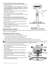
Installation Instructions - Page 1
... or nuts, washers, and bolts) are available at most marine dealers. The size of the larger size, you experience difficulty installing the chartplotter, seek the assistance of two ways. GPSMAP® 4000/5000 Series Installation Instructions
The GPSMAP 4000/5000 series chartplotter and GPS antenna must be properly installed according to bail mount the...
Installation Instructions - Page 5
... in your product box. See page 9. OD pipe-threaded-pole marine mount (14 threads- per-inch-not included), or even install a GPS 17x antenna under a
fiberglass surface. OK Radar
3 ft. (1 m) VHF Radio Antenna
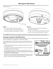
GPS 17x Placement Considerations
GPSMAP 4000/5000 Series Installation Instructions
See page 7.
• Connects to a standard 1 in the preferred mounting location...
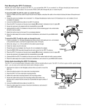
Installation Instructions - Page 6
...
the
mounting
holes
using
a
/11 64
in.
(4.5
mm)
drill
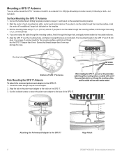
bit. To attach the enclosed pole-mount adapter to the GPS 17
Align Notch GPSMAP 4000/5000 Series Installation Instructions OD pipe-threaded-pole marine mount (14 threads per inch-not
included). Mark the center of the unit. If
you plan to the notch...
Installation Instructions - Page 7
....
7. Cable run externally
To mount the GPS 17 with a marine sealant.
4. Note: If you are tightened.
3. Place the seal pad on fiberglass, it to your NMEA 2000 network.
➋
GPS 17x antenna
➌
Rubber gasket
GPSMAP 4000/5000 Series Installation Instructions
Use the included M4 screws to attach the surface-mount bracket to the...
Installation Instructions - Page 8
... will not acquire satellite signals through the pole-mount adapter, and place the cable in the vertical cable slot with a marine sealant.
9. Adhesive pads
Mounting surface
GPS 17x antenna
Under-deck mounting bracket
GPSMAP 4000/5000 Series Installation Instructions Drill a hole using a 3/4 in the preferred location, and mark the approximate center of the...
Installation Instructions - Page 9
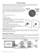
... ) >
White (data out)
>
Wiring the GPSMAP 4000/5000 Unit and the GPS 17
>
GPS 17 GPS/WAAS
Sensor
GPSMAP 4000/5000 Series Installation Instructions
Refer to the diagram
below when wiring the GPS 17 to the diagram for a finished look. Use 22 AWG shielded wiring for the power,
NMEA, Marine Network, or
GPS 17 cable. Garmin rubber grommets...
Installation Instructions - Page 12
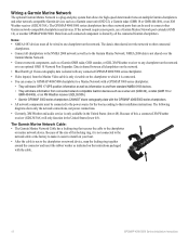
... series chartplotter: • They will share GPS 17 GPS position information as well as information to the Garmin Marine Network.
The data is then shared over the Garmin Marine Network.
• Connect network components, such as a Garmin GMR radar, GSD sounder, or GDL XM Weather receiver to any connected GPSMAP 4000/5000 series chartplotter.
• Video...
Installation Instructions - Page 14
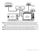
... port expander
xxxxxxxxxxxxxxxxxxxxxxx
To transducer
GDL 30/30A XM weather receiver
Garmin GPSMAP 3000 series
chartplotter
Garmin GPSMAP 4000/5000
series chartplotter
Connecting a GPSMAP 4000/5000 Series Chartplotter to an Existing Garmin Marine Network
Note: When connecting a GPSMAP 4000/5000 series chartplotter to an existing Garmin Marine Network, the GMS 10 can be connected to the power...
Installation Instructions - Page 20
... the chartplotter until it is up-to overtighten the locking ring.
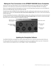
Making the Final Connections to the GPSMAP 4000/5000 Series Chartplotter
After the power cable and the GPS antenna (as well as any optional Garmin Marine Network devices, NMEA 0183 devices, NMEA 2000 connections, or video connections) are seven connectors on the...
Technical Reference for Garmin NMEA 2000 Products - Page 4
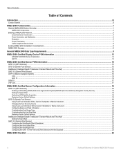
...-Certified Display Device PGN Information...13
GPSMAP 4000/5000 Series Chartplotters...13 GMI 10...14
NMEA 2000-Certified Sensor PGN Information...15 GPS 17x (GPS Antenna)...15 GFS 10 (Garmin Fuel... With a Garmin Chartplotter or Marine Instrument...19 Changing the Fuel Economy Source...19 Using Fuel-Level Information With a Garmin Chartplotter or Marine Instrument...19 Configuring Engine and Tank...
Technical Reference for Garmin NMEA 2000 Products - Page 19
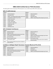
...list the non-proprietary PGN information for Garmin NMEA 2000 Products 15 GPS 17x (GPS Antenna)
Transmit
Receive
059392 060928 126208 126464 126992 126996 129025 129026 129029 129539 129540
ISO... Parameters, Engine Fluid Level (when calibrated using a Garmin chartplotter or marine instrument)
ISO Acknowledgement ISO Request ISO Address Claim NMEA-Command/Request/Acknowledge Group ...
Technical Reference for Garmin NMEA 2000 Products - Page 23
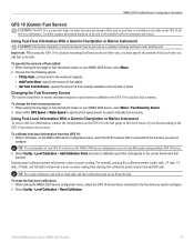
... either GPS Speed or Water Speed to specify which speed sensor is used on the fuel-flow rate. Changing the Fuel Economy Source The Garmin chartplotter or marine instrument requires...for fuel-level information. Using Fuel-Level Information With a Garmin Chartplotter or Marine Instrument To receive fuel-level information, connect the wiring harness on the NMEA 2000 device configuration...
Important Safety and Product Infomation (Multilingual) - Page 2
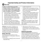
...goals of
Battery Warnings Your GPS unit may use an internal...as a navigational aid.
In
Important Safety and Product Information
Warnings
Failure to all available navigation sources, including information from visual sightings, local waterway... resulting in
recycled. Official government charts and notices to mariners contain all data sources contain some inaccurate or incomplete data...
Owner's Manual - Page 4
...Off 2 Initializing Unit Settings 2 Adjusting the Backlight 3 Acquiring GPS Satellite Signals 3 Inserting and Removing SD Cards 4 Restoring ...Using BlueChart g2 Vision 14 Using Mariner's Eye 3D 14 Using Fish...45 Understanding the Split Zoom Screen...........45 Understanding the... Viewing the DSC List 50 Receiving Distress Calls 50 Man-Overboard ...GPSMAP® 4000/5000 Series Owner's Manual
Owner's Manual - Page 13
...off (page 27). Data bars
GPSMAP® 4000/5000 Series Owner's Manual
High-resolution satellite imagery is connected to off .
Tides/Currents-turns the display of marine service points on or off . ..., Range, and Fuel Economy data bar on or off. • Sailing-turn the GPS Speed, GPS Heading, Depth, and GPS Position data bar on or off , land only, or blend.
True wind or apparent...
Owner's Manual - Page 18
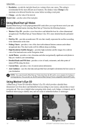
...3D-
Mariner's Eye 3D 14
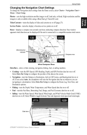
Navigation Chart GPSMAP® 4000/5000 Series Owner's Manual Track Color-sets the color of the interval. Using Mariner's Eye 3D
A BlueChart g2 Vision SD card offers Mariner's Eye... to get the most -efficient use the SD card on BlueChart g2 Vision-compatible Garmin GPS units. Using Charts
Using Charts
• Resolution-records the track plot based on a ...
Owner's Manual - Page 39
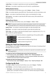
...) to receive sonar information. Note: To receive fuel-level information, your chartplotter to work. Use the ROCKER (GPSMAP 4000 series) or onscreen keyboard (GPSMAP 5000 series) to sound when the GPS location accuracy... connected to the sounder module) wired through NMEA 0183 or connected to the Garmin Marine Network to allow when calculating an auto guidance path. sounds an alarm for all ...
Owner's Manual - Page 41
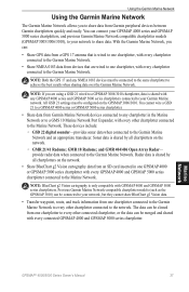
... devices between Garmin chartplotters quickly and easily. Previous Garmin Marine Network-compatible chartplotter models (such as the GPSMAP 3010) can :
• Share GPS data from an SD card inserted in the Marine Network or to a GMS 10 Marine Network Port Expander, with every connected GPSMAP 4000 and GPSMAP 5000 series chartplotter. You can be merged and shared...
Owner's Manual - Page 49
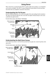
... view a full-screen graph of detected objects as a fishfinder. From the Home screen, select Sonar > Split Zoom. Depth, temperature, and water speed
Zoomed depth scale
GPS speed and GPS heading
Zoom level
Zoom
Range
window
Transducer frequency
Using Sonar
GPSMAP® 4000/5000 Series Owner's Manual
45
The range scale along the right side of the screen...
Owner's Manual - Page 63
... object information 8 appearance 10 borders 11 detail 10 fish eye 3D 6 fishing 6 mariner's eye 6 navigation 6 panning 7 settings 9 using 6 zooming 6 clear user data 30 colors 15 color mode 3 color scheme 47 combinations 19-... 37, 39 go to 21 GPS satellite signals 3, 32 GSD 22 37 guide to 21
H
Hazard Colors 15 heading 33 Heading Line 10
GPSMAP® 4000/5000 Series Owner's...
Similar Questions

How Do I Go Into Simulation Mode On A Garmin Marine Gps Modle741xs
how do I use simulation mode on a garmin 741xs marine ver
how do I use simulation mode on a garmin 741xs marine ver
(Posted by Curthupp 6 years ago)


What Is The Difference Between Garmin Gpsmap 172 And 172 Gps Receiver
(Posted by nbkqReg 10 years ago)

In Uk Where Repair Gps 172c Rom Failure
gps 172c was very slow to aquire sats; now every time power up map and gps steady but compass way of...
gps 172c was very slow to aquire sats; now every time power up map and gps steady but compass way of...
(Posted by davidriley100 11 years ago)