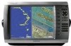
Garmin GPSMAP 4012 Support Question
Garmin GPSMAP 4012 Support Question
Find answers below for this question about Garmin GPSMAP 4012 - Marine GPS Receiver.Need a Garmin GPSMAP 4012 manual? We have 8 online manuals for this item!
Question posted by CHRISSHELLY on June 12th, 2011
No Signal From Antenna?
We feel we have wired the entenna int the gpsmap 4012 properly, but we are still not recieving a signal and cannot get any charts working ect. what on earth are we doing wrong?
Current Answers
Related Garmin GPSMAP 4012 Manual Pages
Installation Instructions - Page 1
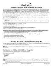
... the assistance of the larger size, you must be properly installed according to flush mount the chartplotter.
Ensure the chartplotter software is on the box. The size of two ways. GPSMAP® 4000/5000 Series Installation Instructions
The GPSMAP 4000/5000 series chartplotter and GPS antenna must : 1. You need the appropriate fasteners, tools, and mounts...
Installation Instructions - Page 5
...installation procedures. OD pipe-threaded-pole marine mount (14 threads- OK Radar
3 ft. (1 m) VHF Radio Antenna
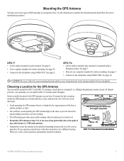
GPS 17x Placement Considerations
GPSMAP 4000/5000 Series Installation Instructions
... the included antenna and follow the correct mounting directions and the correct wiring directions for the GPS antenna on the mast, to the chartplotter using NMEA 0183. GPS 17 •...
Installation Instructions - Page 6
...adapter to the outside of each mounting hole with marine sealant. Attaching the Pole-mount Adapter to the GPS 17: 1.
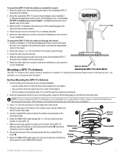
If you can surface mount the GPS 17 antenna or install it on a standard 1 in ...proper length for the mounting surface, which do not thread into the GPS 17 deeper than 8 mm may damage the case.
To attach the enclosed pole-mount adapter to the GPS 17
Align Notch GPSMAP...
Installation Instructions - Page 7
... mount, fill the remaining gap in . (19 mm) drill bit for your NMEA 2000 network.
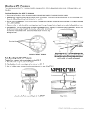
➋
GPS 17x antenna
➌
Rubber gasket
GPSMAP 4000/5000 Series Installation Instructions
To mount the GPS 17 with a marine sealant.
4. Screw the assembled GPS 17 and pole-mount adapter onto a standard 1 in the preferred location, and mark the approximate center...
Installation Instructions - Page 8
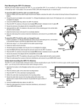
...OD pipe-threaded-pole marine mount (14 threads per inch-not included). Fasten the marine mount to the GPS 17x antenna.
4. Route the NMEA...GPS 17x will not acquire satellite signals through . 3. Use extreme care to the GPS 17x.
7. Adhesive pads
Mounting surface
GPS 17x antenna
Under-deck mounting bracket
GPSMAP 4000/5000 Series Installation Instructions Pole Mounting the GPS 17x Antenna...
Installation Instructions - Page 9
...wire to the NMEA 0183
cable or GPS 17 cable. The grommets do not wire more than one chartplotter to cover these cables. Be sure to a Garmin Marine Network.
Refer to the power cable.
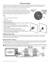
Wiring the GPS 17 Antenna
The GPS 17 antenna must be wired... cable, and a 17-pin Marine Video cable. The GPS signal is seated. Wiring and Cables
The GPSMAP 4000/5000 series chartplotter comes with...
Installation Instructions - Page 12
...Garmin GMR radar, GSD sounder, or GDL XM Weather receiver to any connected GPSMAP 4000/5000 series chartplotter.
• Video input(s) from the Marine Video cable is only viewable on the chartplotter to which... any chartplotter on the instructions packaged with the GPSMAP 4000/5000 series chartplotters.
• All network components must all be wired to make it is only available in the ...
Installation Instructions - Page 14
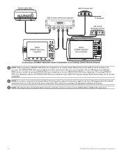
Wire the GPS antenna and additional NMEA devices to the appropriate installation instructions. Note: Every device connected to the Garmin Marine Network must be used but do not share cartography. Wire each device according to either the existing GPSMAP 3000 series chartplotter or the new GPSMAP 4000/5000 Series chartplotter. Note: This diagram shows the Garmin Marine Network connections...
Installation Instructions - Page 20
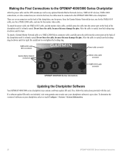
Making the Final Connections to the GPSMAP 4000/5000 Series Chartplotter
After the power cable and the GPS antenna (as well as any optional Garmin Marine Network devices, NMEA 0183 devices, NMEA 2000... NMEA 2000 cable, and one for the marine video cable.
After the cable is tight.
If so, follow the instructions provided with the card.
There are wired to the boat, the cables must be ...
Remote Instructions (Multilingual) - Page 1
...; Reorient or relocate the receiving antenna. • Increase the separation between the equipment and the receiver. • Connect the equipment... the equipment off and on a different circuit from the GPS unit. • Consult the dealer or an experienced radio...and supplemental information concerning the use and operation of Garmin. GPSMAP® is a trademark of the FCC interference limits ...
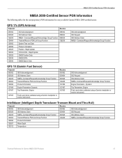
Technical Reference for Garmin NMEA 2000 Products - Page 4
... Distribution...5 Examples...5 Proper Termination...7 Cable Length and Device Limits...8 Existing NMEA 2000 Installation Considerations...8 NMEA 2000 Glossary...8
General NMEA 2000 Data Type Requirements...9
NMEA 2000-Certified Display Device PGN Information...13
GPSMAP 4000/5000 Series Chartplotters...13 GMI 10...14
NMEA 2000-Certified Sensor PGN Information...15 GPS 17x (GPS Antenna)...15 GFS 10...
Technical Reference for Garmin NMEA 2000 Products - Page 19
... Claim NMEA - Dynamic
Trip Parameters, Engine Fluid Level (when calibrated using a Garmin chartplotter or marine instrument)
ISO Acknowledgement ISO Request ISO Address Claim NMEA-Command/Request/Acknowledge Group Function Engine Parameters - GPS 17x (GPS Antenna)
Transmit
Receive
059392 060928 126208 126464 126992 126996 129025 129026 129029 129539 129540
ISO Acknowledgment ISO Address...
Technical Reference for Garmin NMEA 2000 Products - Page 23
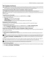
... Menu > Fuel Economy Source. 2. Choose from the GFS 10: 1. Select either GPS Speed or Water Speed to specify which speed sensor is shown on your boat according to ...amount of fuel added: 1. Using Fuel-Level Information With a Garmin Chartplotter or Marine Instrument To receive fuel-level information, connect the wiring harness on your NMEA 2000 device, select Menu. 2. Select Config > Level ...
Owner's Manual - Page 3
...'s Manual
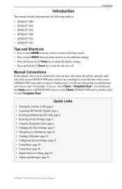
For example, if you see "select Charts > Navigation Chart," you should press the Charts soft key (GPSMAP 4000 series) or touch Charts (GPSMAP 5000 series), and then select or touch Navigation Chart. Small arrows (>) in order. Quick Links
• Turning the Unit On or Off: page 2. • Acquiring GPS Satellite Signals: page 3. • Inserting and Removing SD Cards...
Owner's Manual - Page 4
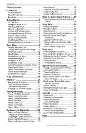
...GPS Satellite Signals 3 Inserting and Removing SD Cards 4 Restoring Factory Settings 4 Viewing System Information 4 Using Simulator Mode 4 Understanding the Home Screen 5
Using Charts 6 Using the Navigation Chart 6 Changing the Navigation Chart Settings.........9 Using Radar Overlay 12 Using Tracks 12 Using BlueChart g2 Vision 14 Using Mariner... DSC List 50 Receiving Distress Calls 50 ...
Owner's Manual - Page 9

...
GPSMAP 5000 Series Home Screen
• Charts-access Navigation Chart, Perspective 3D, Mariner's Eye 3D, Fish Eye 3D, Fishing Charts and Radar Overlay (page 6). GPSMAP® 4000/5000 Series Owner's Manual Select Home from any screen to return to your current location as a waypoint or MOB
(GPSMAP 5000 Series). • Man Overboard-navigate to a Man Overboard location (GPSMAP...
Owner's Manual - Page 18
.... Mariner's Eye 3D 14
Navigation Chart GPSMAP® 4000/5000 Series Owner's Manual
You can only use of the track plot.
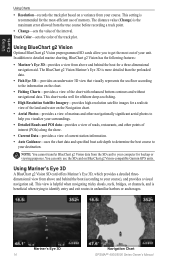
Using BlueChart g2 Vision
Optional BlueChart g2 Vision preprogrammed SD cards allow you visualize your unit. The distance value (Change) is more detailed than the preloaded data.
• Fish Eye 3D- This chart works...
Owner's Manual - Page 39
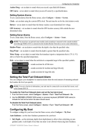
...settings for the clock alarm to work. GPSMAP® 4000/5000 Series Owner's Manual
35 Configuring the Chartplotter
Anchor Drag-set an alarm to sound when the GPS location accuracy falls outside the userdetermined ... sonar module (and a transducer connected to the sounder module) wired through NMEA 0183 or connected to the Garmin Marine Network to sound when the unit detects a suspended target of...
Owner's Manual - Page 41
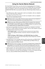
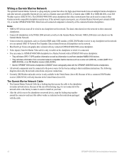
... the Garmin Marine Network. Using the Garmin Marine Network
Using the Garmin Marine Network
The Garmin Marine Network allows you can:
• Share GPS data from a GPS 17 antenna that is wired to one chartplotter, with every chartplotter connected to the Garmin Marine Network.
• Share NMEA 0183 data from devices that are using a GSD 21 wired to a GPSMAP 3006/3010...
Owner's Manual - Page 63
...water speed 36 celestial information 28 chart appearance 10 chart data 7 chartplotter capabilities 49 charts 5, 6
additional object information 8 appearance 10 borders 11 detail 10 fish eye 3D 6 fishing 6 mariner's eye 6 navigation 6 panning...39 go to 21 GPS satellite signals 3, 32 GSD 22 37 guide to 21
H
Hazard Colors 15 heading 33 Heading Line 10
GPSMAP® 4000/5000 Series...
Similar Questions

Gpsmap 492 Stopped Recieveing Satelite . Changed Antenna. No Help .any Ideas ?
(Posted by josie187 2 years ago)

How Do I Go Into Simulation Mode On A Garmin Marine Gps Modle741xs
how do I use simulation mode on a garmin 741xs marine ver
how do I use simulation mode on a garmin 741xs marine ver
(Posted by Curthupp 6 years ago)


Gpsmap 76csx. Rocker Switch Does Not Work Down Or Right.
I had battery corrosion. Cleaned it out and replaced the batteries, but now the rocker switch will n...
I had battery corrosion. Cleaned it out and replaced the batteries, but now the rocker switch will n...
(Posted by csears48 10 years ago)

I Forgot To Lower My Antenna For Gps Units And The Tops Were Torn Off. Help!
I have a basic GPS and a 5212 unit and both antenna were damaged by low haing branches. The tops wer...
I have a basic GPS and a 5212 unit and both antenna were damaged by low haing branches. The tops wer...
(Posted by DrG5159 10 years ago)