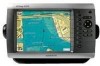
Garmin GPSMAP 4008 Support Question
Garmin GPSMAP 4008 Support Question
Find answers below for this question about Garmin GPSMAP 4008 - Marine GPS Receiver.Need a Garmin GPSMAP 4008 manual? We have 8 online manuals for this item!
Current Answers
Related Garmin GPSMAP 4008 Manual Pages
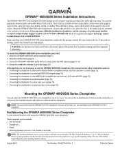
Installation Instructions - Page 1
...F
Printed in each section. or contact Garmin Product Support by phone at most marine dealers.
Note: You cannot bail mount the GPSMAP 5015/5215 chartplotters. Tools required (not ...GPSMAP® 4000/5000 Series Installation Instructions
The GPSMAP 4000/5000 series chartplotter and GPS antenna must : 1. To install the GPSMAP 4000/5000 series chartplotter, you can mount the GPSMAP...
Installation Instructions - Page 9
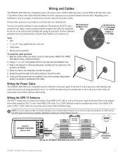
... Garmin at the split and place it may not need the grommets in . (31.7 mm) paddle drill bit or hole saw
Split
• Utility knife
• Marine sealant (optional)
To install the cable grommet: 1. Carefully trim the cable hole in ) >
White (data out)
>
Wiring the GPSMAP 4000/5000 Unit and the GPS 17
>
GPS 17 GPS...
Installation Instructions - Page 12
.../406), or an XM Weather receiver (GDL30/30A). • Garmin GPSMAP 3000 series chartplotters CANNOT share cartography data with a GPSMAP 3000 series chartplotter: • They will share GPS 17 GPS position information as well as to the Garmin Marine Network. Because of this , a connected XM Weather receiver (GDL30/30A) will share information from the Marine Video cable is only viewable...
Installation Instructions - Page 14
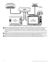
... port expander
xxxxxxxxxxxxxxxxxxxxxxx
To transducer
GDL 30/30A XM weather receiver
Garmin GPSMAP 3000 series
chartplotter
Garmin GPSMAP 4000/5000
series chartplotter
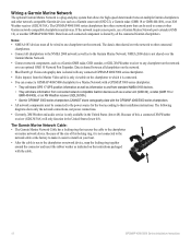
Connecting a GPSMAP 4000/5000 Series Chartplotter to an Existing Garmin Marine Network
Note: When connecting a GPSMAP 4000/5000 series chartplotter to an existing Garmin Marine Network, the GMS 10 can be connected to the power...
Installation Instructions - Page 20
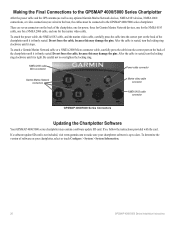
... it is seated, turn the locking ring clockwise until it stops.
Making the Final Connections to the GPSMAP 4000/5000 Series Chartplotter
After the power cable and the GPS antenna (as well as any optional Garmin Marine Network devices, NMEA 0183 devices, NMEA 2000 connections, or video connections) are seven connectors on the back...
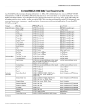
Technical Reference for Garmin NMEA 2000 Products - Page 4
... Display Device PGN Information...13
GPSMAP 4000/5000 Series Chartplotters...13 GMI 10...14
NMEA 2000-Certified Sensor PGN Information...15 GPS 17x (GPS Antenna)...15 GFS 10 (Garmin Fuel Sensor)...15 Intelliducer (Intelligent Depth Transducer-Transom Mount and Thru-Hull)...15 GWS 10 (Garmin Wind Sensor)...16 GHP 10 (Marine Autopilot System)...16
CCU...16...
Technical Reference for Garmin NMEA 2000 Products - Page 6
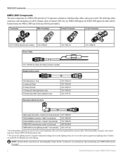
... protect against direct lightning strikes. See page 4.
Technical Reference for lightning-strike related damage. T-connector
Male Terminator
Female Terminator
In-line Terminator
010-11078-00 (Garmin part number) 010-11080-00 Power Cable
010-11081-00
010-11079-00 (2 meters [6.5 feet]) (3 A fuse included) Backbone/Drop Cable
305 millimeters (1 foot) 2 meters (6.5 feet) 6 meters...
Technical Reference for Garmin NMEA 2000 Products - Page 13
...Garmin Chartplotter and GPS Antenna
Garmin Chartplotter and GPS Antenna
Garmin Chartplotter Garmin Chartplotter and GPS Antenna Garmin Chartplotter and GPS Antenna Garmin Chartplotter and GPS Antenna Garmin Chartplotter and GPS Antenna Heading Sensor GPS...Waypoint Distance to the NMEA 2000-certified display devices (such as a GPSMAP 4000/5000 series chartplotter or a GMI 10) on the fuel speed ...
Technical Reference for Garmin NMEA 2000 Products - Page 14

...; Wind Sensor and a Water Speed
Sensor, and a Heading Sensor
(Continued)
10
Technical Reference for Garmin NMEA 2000 Products GNSS Position
Typical Sender GPS Antenna
129026 - Nav Data
Garmin Chartplotter and GPS Antenna
129026 - GNSS Position GPS Antenna
129026 - GNSS Position GPS Antenna
129026 - Envir Param
Air Temperature Sensor
130313 - Water Speed
(If a Heading Sensor and...
Technical Reference for Garmin NMEA 2000 Products - Page 15

... Speed Sensor are not present, a less accurate reading can be calculated using only the Wind Sensor, Water Speed Sensor, and Heading Sensor [130306 - Nav Data
Garmin Chartplotter and GPS Antenna
Maximum Apparent Wind Speed 130306 - Water Speed (If a Water Speed Sensor is not present, a less accurate reading can be calculated using...
Technical Reference for Garmin NMEA 2000 Products - Page 19
... a Garmin chartplotter or marine instrument)
ISO Acknowledgement ISO Request ISO Address Claim NMEA-Command/Request/Acknowledge Group Function Engine Parameters - NMEA 2000-Certified Sensor PGN Information
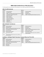
NMEA 2000-Certified Sensor PGN Information
The following tables list the non-proprietary PGN information for Garmin NMEA 2000 Products 15 GPS 17x (GPS Antenna)
Transmit
Receive
059392...
Technical Reference for Garmin NMEA 2000 Products - Page 23
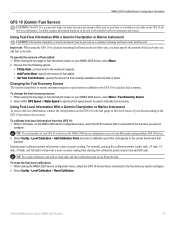
...> Fuel Economy Source. 2. Select either GPS Speed or Water Speed to specify which ...Fuel-Level Information With a Garmin Chartplotter or Marine Instrument To receive fuel-level information, connect ...serial number of fuel each GFS 10 is used on your boat according to
configure. Using Fuel-Flow Information With a Garmin Chartplotter or Marine Instrument
Caution: The Garmin chartplotter or marine...
Technical Reference for Garmin NMEA 2000 Products - Page 24
... received from the following options:
• Engine Number-for a multi-engine installation, assign the selected GFS 10 to a specific engine. • Tank Number-for..., select the GFS 10 device. 2.
Tip: The serial number of each GFS 10 is associated with each GFS 10...specify which engine or tank is shown on your Garmin chartplotter or marine instrument changes with the engine RPM, the GFS ...
Owner's Manual - Page 4
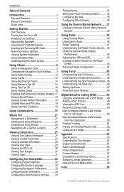
... Initializing Unit Settings 2 Adjusting the Backlight 3 Acquiring GPS Satellite Signals 3 Inserting and Removing SD Cards 4 Restoring...BlueChart g2 Vision 14 Using Mariner's Eye 3D 14 Using...25 Navigating with a Garmin Autopilot 26
Viewing ...the Garmin Marine Network........37 Viewing Connected Garmin Marine ... the DSC List 50 Receiving Distress Calls 50 Man-...Garmin 57 Declaration of Conformity (DoC ...
Owner's Manual - Page 8
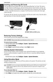
... Configure > System > System Information. Using Simulator Mode
Simulator Mode turns the GPS receiver off . Select Setup to purchase additional map data information. Insert optional BlueChart&#...Garmin unit or a computer. Card label
GPSMAP 4010 and 4012
Card label GPSMAP 4008 and 5000 series
Restoring Factory Settings
You can view the software version, basemap version, and unit ID number...
Owner's Manual - Page 18
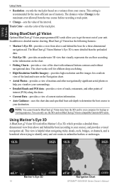
...to determine the best course to
your destination. Mariner's Eye 3D 14
Navigation Chart GPSMAP® 4000/5000 Series Owner's Manual
The BlueChart g2 Vision Mariner's Eye 3D is recommended for a realistic ... you to get the most -efficient use the SD card on BlueChart g2 Vision-compatible Garmin GPS units. Note: You cannot transfer BlueChart g2 Vision data from above and behind the boat...
Owner's Manual - Page 39
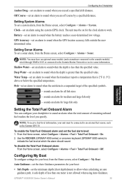
...connected to the Garmin Marine Network to receive sonar information. sounds an alarm for all fish sizes
-
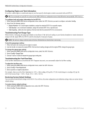
Configuring My Boat
To configure settings for the clock alarm to work. GPSMAP® 4000/5000...Alarms > System.
Shallow Water-set an alarm to sound when the GPS location accuracy falls outside the userdetermined value. GPS Accuracy-set an alarm to
indicate the fuel level at which the ...
Owner's Manual - Page 41
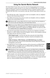
With the Garmin Marine Network, you can:
• Share GPS data from a GPS 17 antenna that are using a GSD 21 wired to a GPSMAP 3006/3010 chartplotter, data is only compatible with every GPSMAP 4000 and GPSMAP 5000 series chartplotter connected to the Marine Network. All GSD 21 settings must be connected to your network, but they cannot share BlueChart...
Owner's Manual - Page 56
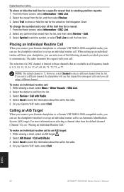
...limited to the radio. 5. NOTE: The default channel is sending position reports: 1. On your Garmin VHF radio, select Call. For more information on the Navigation Chart. Select AIS Vessel > Call...the line color. DSC
52
GPSMAP® 4000/5000 Series Owner's Manual The radio transmits this request with your call from your Garmin chartplotter to a Garmin VHF NMEA 2000-compatible radio,...
Owner's Manual - Page 59
...-fan voltage is not supported. DSC Position Report Received From -a position report has been received by the DSC module. Contact Garmin Product Support. Default value selected.-an invalid entry was entered.
Enter a number between (0 - 252)-invalid NMEA 2000 Device instance. Lost Remote GPS Connection-connection to the GPS 17 antenna. Map Format Is Not Supported-a map...
Similar Questions

Garmin 4008 Screen Problem
Screen has seemingly random squares of light and dark patches appearing on it. Seems like some of th...
Screen has seemingly random squares of light and dark patches appearing on it. Seems like some of th...
(Posted by artnew1955 6 years ago)

How Do I Go Into Simulation Mode On A Garmin Marine Gps Modle741xs
how do I use simulation mode on a garmin 741xs marine ver
how do I use simulation mode on a garmin 741xs marine ver
(Posted by Curthupp 6 years ago)

541s Marine Gps. Depth Not Reading Out.
Depth has been working since installed. Now blank. Is there an on off control for this that may have...
Depth has been working since installed. Now blank. Is there an on off control for this that may have...
(Posted by therad50 11 years ago)


Garmin Gpsmap 4008 & 4208
What is the difference in the Garmin gpsmap 4008 & 4208?
What is the difference in the Garmin gpsmap 4008 & 4208?
(Posted by hc3d 12 years ago)