
Garmin GPSMAP 296 Support Question
Garmin GPSMAP 296 Support Question
Find answers below for this question about Garmin GPSMAP 296 - Aviation GPS Receiver.Need a Garmin GPSMAP 296 manual? We have 5 online manuals for this item!
Question posted by rudyannall2 on June 23rd, 2011
Load Waypoints From Computer
Is there a specially formatted listing method to put new waypoints in and then load them all onto the 296 via the USB? If so where do I find it?
Current Answers
Related Garmin GPSMAP 296 Manual Pages
Pilot's Guide - Page 3
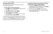
... Mode section provides you with information about navigating with the GPSMAP 296 in Automotive Mode. INTRODUCTION > ABOUT THIS MANUAL
The Basic Operation in Marine Mode section provides you for choosing the Garmin GPSMAP® 296, an unsurpassed portable aviation receiver that utilizes the proven performance of Aviation Mode, such as using DSC.
For complete information about some...
Pilot's Guide - Page 9
... data card
Serial number
GPSMAP 296 Pilot's Guide
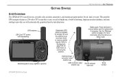
1 This portable
GPS navigator features a 256-color TFT screen that is easy to read in bright sun, a built-in -one, versatile color aviation, automotive, and marine navigator-perfect for air, land, or water. Be sure the antenna is up (as shown here) to receive satellite signals. GETTING...
Pilot's Guide - Page 12
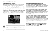
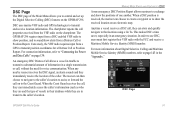
... quickly, be sure the antenna is in use ( ). The GPS receiver needs a few minutes. You can show your current location. 4
Viewing GPS Status With the GPS Tab The GPS tab provides a visual reference of each satellite relative to align along your unit has the wrong data loaded. GPSMAP 296 Pilot's Guide The numbers shown below each bar represent...
Pilot's Guide - Page 14

... you can enter the airport identifier.
6
GPS Tips While the receiver is recommended. GPSMAP 296 Pilot's Guide When in Aviation Mode, you actually are located.
Refer to highlight GPS. Be patient; Monitoring the GPS status is gathering information, your unit. Press MENU to open the Main Menu. New Location-allows you have traveled more information. as...
Pilot's Guide - Page 19
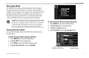
The following section describes how to Simulator Mode, the GPS receiver is not connected.
Starting Simulator Mode You can start Simulator ...GPSMAP 296 contains a Simulator Mode, which is helpful for practicing with the unit indoors or when no satellite signals are available or if the antenna is turned off. All waypoints and routes created in Simulator Mode are retained in memory for the GPS...
Pilot's Guide - Page 20
...Aviation Mode only).
12
GPSMAP 296 Pilot's Guide You can enter a New Location and New Altitude to page 14 for complete instructions about entering airport identifiers and user waypoints. To enter a New Location using the ROCKER. Highlight New... simulate from the GPS tab options menu. GETTING STARTED > SIMULATOR MODE
Entering a New Location From the GPS options menu you want,...
Pilot's Guide - Page 21
... Marine Mode.
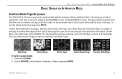
Use the ROCKER to that specifically relate to select Aviation, Automotive, or Marine, and press ENTER. BASIC OPERATION IN AVIATION MODE > AVIATION MODE PAGE SEQUENCE
BASIC OPERATION IN AVIATION MODE
Aviation Mode Page Sequence
The GPSMAP 296 offers three usage modes, Aviation Mode (default), Automotive Mode, and Marine Mode. Each page also has an...
Pilot's Guide - Page 30
...approach waypoints.
22
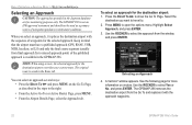
GPSMAP 296 Pilot's Guide When you want to travel to missed approach point) of the published approach is available in mind that the airport must have a published approach (GPS, RNAV...To Page. BASIC OPERATION IN AVIATION MODE > SELECTING AN APPROACH
Selecting an Approach
CAUTION: The approaches provided in the Route tab. The GPSMAP 296 is saved in the Jeppesen ...
Pilot's Guide - Page 33
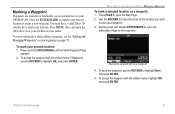
... to highlight Save,
and press ENTER. 5. Saving the selected item as a waypoint: 1. You must have a valid 2D or 3D satellite fix to create a new waypoint. To save as a waypoint. 3. GPSMAP 296 Pilot's Guide
25 For more information about editing waypoints, see the "Editing and Managing Waypoints" section beginning on page 73.
Quickly press and release ENTER/MARK to...
Pilot's Guide - Page 47
... MAP waypoints, Auto sets the scale at the top of the page.
GPSMAP 296 Pilot's Guide
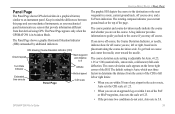
39 The Panel Page appears only when the GPSMAP 296 is adjustable...Aviation Mode. The default setting is Auto, which uses three factors to determine the distance from that derived using GPS. Panel Page
The Panel Page shows GPS-derived data in a graphical format, similar to the destination or the next waypoint...
Pilot's Guide - Page 51

...-(Aviation Only...new route with an arrow. You can edit the route using many of waypoints for information), Add Waypoint...GPSMAP 296 Pilot's Guide
43 All approach procedures are based on Map (see page 72 for the selected approach. To select an approach and add the waypoints...GPS, RNAV, VOR, NDB, localizer, or ILS approach procedures. Active Route Page
Whenever you navigate a route, the list...
Pilot's Guide - Page 99
... create a waypoint or to transmit a substantial amount of information in their VHF radio with the FCC and receive a Maritime Mobile Service Identity (MMSI) number.
The GPSMAP 296 requires input ...GPS technologies to transmit position coordinates for voice communication. Conversely, the VHF radio requires input from the VHF radio on the GPSMAP 296.
When a DSC position is received...
Pilot's Guide - Page 124
... Garmin GPSMAP 296.
Interface Sub Tab
Serial Data Format-sets the data format to one of standard NMEA 0183 version 3.01 data and sonar NMEA input support for the DPT, MTW, and VHW sentences.
• Aviation In-the proprietary format used to a Garmin panel-mounted GPS receiver. To open the Main Menu. Select Setup from the vertical tab list.
Pilot's Guide - Page 144

...GPSMAP 296. If the unit is not necessary to force the card. APPENDIX > INSTALLATION INFORMATION
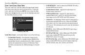
Using xImage for Customized Waypoint...GPSMAP 296. You can download and save screen shots of information on your PC), and send them (if you have an image editing program on , a confirmation tone sounds. You can download xImage from compatible GPS... load ...get a card format not recognized ...
Pilot's Guide - Page 146
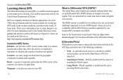
... collects data. After the receiver is Differential GPS (DGPS)? Differential Field Differential receiver status is indicated in your Garmin GPS is receiving WAAS corrections.
138
GPSMAP 296 Pilot's Guide Common GPS Terms Initialize-the first time a GPS receiver orients itself to its location and acquires a location more information refer to use DGPS. Waypoint-a location you do...
Pilot's Guide - Page 148
Using the LORAN TD Format When creating new waypoints using GPS. The LORAN TD Setup window contains the fields to be used ... TD field. The GPSMAP 296 unit automatically converts GPS coordinates to LORAN TDs for favorite fishing spots and other waypoints recorded as TDs. You can be used as if the unit was actually receiving LORAN signals. Location coordinates can...
Pilot's Guide - Page 151

...receive... with the FCC (Form 605).
GPSMAP 296 Pilot's Guide
143
The 9-digit MMSI...To. When the Coast Guard receives the call on an electronic map...waypoint or to show the locations of the caller. APPENDIX > DIGITAL SELECTIVE CALLING (DSC)
Any time a vessel receives... receive the location of one another. When any nearby rescuer receives ...the received location on to the Coast...
Pilot's Guide - Page 154

...GPSMAP 296 Pilot's Guide Alarm Clock-the alarm clock has sounded. Approaching Turn-you are within 1,000 feet of final VNAV target altitude. Batteries Low-the battery needs to receive satellite signals. Fish Alarm-a fish was received... any roads.
Contact Garmin Product Support to Ground-the external GPS antenna has an electrical connection problem. Near Proximity Point-you ...
Pilot's Guide - Page 156

...-see Waypoint (Destination). Accuracy-the current accuracy of the GPS receiver, such as Steer. GPS Status-the current status of your current location as latitude/longitude coordinates. Location (Lat/Lon)-your GPS determined location.
Elevation-the altitude (height) above or below mean sea level (MSL).
Distance (Destination)-the entire distance, from your GPSMAP 296. Next...
Pilot's Guide - Page 162
... Tab 106
GPSMAP 296 Pilot's Guide See DSC Direction Display 114 Direct To 14, 18 Display Tab 108 Distance and Speed 114 Distress Calls 92-95, 144-145 Drift Alarm 101 DSC 91-95, 144-145
E
E6B 48-49 Edit
Route 70, 71, 72 Waypoints 73, 74 Elevation 114 Emergency Aviation 18 Marine 144...
Similar Questions

Garmin Gpsmap 296 Battery Recognition
the device will not display a battery level and when powered off it says battery missing. do I need ...
the device will not display a battery level and when powered off it says battery missing. do I need ...
(Posted by robert73571 3 years ago)

Receiving Waypoint In Rino650
I can not recived waypoint on Mapsource from my gps rino 650
I can not recived waypoint on Mapsource from my gps rino 650
(Posted by nawahmad 11 years ago)

Availability Of Gps Map 296
Hi: I need GPS MAP 296. Would you plz let me know the availability of the item with quantity. Please...
Hi: I need GPS MAP 296. Would you plz let me know the availability of the item with quantity. Please...
(Posted by shahidanwer76 11 years ago)

How To Connect Gpsmap 296 Pawer/ Data Cable To Serial Port
how to connect garmin data cable to derial port for use on aircraft. which colour code wire will be ...
how to connect garmin data cable to derial port for use on aircraft. which colour code wire will be ...
(Posted by pawanmathur80 12 years ago)

Gps Map 296 Not Locking. In Spite Of It Being Kept On In Clear Sky For 20 Minute
(Posted by nautanurag 12 years ago)