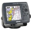
Garmin GPSMAP 172C Support Question
Garmin GPSMAP 172C Support Question
Find answers below for this question about Garmin GPSMAP 172C - Marine GPS Receiver.Need a Garmin GPSMAP 172C manual? We have 2 online manuals for this item!
Question posted by magicach on May 13th, 2014
Can't Get My Garmin Map 172c To Show Maps From My Garmin Bluechart Card
The person who posted this question about this Garmin product did not include a detailed explanation. Please use the "Request More Information" button to the right if more details would help you to answer this question.
Current Answers
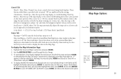
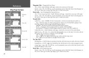
Related Garmin GPSMAP 172C Manual Pages
Flush Mount Template - Page 1
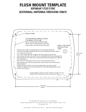
...and the Mounting Hole. Provide adequate clearance to press together the data card cover handles and for the data card cover to lock
the first one Hex Nut per
Mounting Stud. ...open freely.
100.0 mm (3.93")
138.0 mm (5.43")
© Copyright 2004 Garmin Ltd.
FLUSH MOUNT TEMPLATE
GPSMAP 172C/178C
(EXTERNAL ANTENNA VERSIONS ONLY)
UNIT OUTLINE
CUT MOUNTING SURFACE ALONG
THE INSIDE OF THIS...
Owner's Manual - Page 3
...GPSMAP 172/172C and provides a Getting Started tour so that the Software in violation of the export control laws of the United States of Garmin GPS and full-featured mapping to
any questions while using your product name needs service. Garmin...the GPSMAP 172 and GPSMAP 172C (color). The Garmin GPSMAP 172/172C models utilize the proven performance of America. To get the most advanced marine ...
Owner's Manual - Page 5
...visual sightings, and maps. Do not attempt to : www.garmin.com/aboutGarmin/environment/...disposal.jsp. For more information go to use the unit for more information on the unit to cause cancer, birth defects, or reproductive harm.
Official government charts and notices to mariners contain all data sources contain some countries, complete and accurate map...
Owner's Manual - Page 7
...backlighting • (172C) 256-color CSTN display with backlighting • 12-channel parallel receiver tracks and uses up to 50 waypoints each • Uploadable maps using Garmin's MapSource PC products and BlueChart Data Cards • Coordinates:... charting capability, the Garmin GPSMAP 172/172C is a powerful navigation device that can give you better accuracy • Differential-Ready ...
Owner's Manual - Page 8
...; EURO A/C, PC Adapter • UK A/C, PC Adapter • Cigarette Lighter Adapter • BlueChart Marine Data Cards, MapSource CDs, USB Data Card Programmer, and Data Cards • GSD 20 Remote Sounder Module • GBR 23 Beacon Receiver for differential corrections
Standard Package: • GPSMAP 172/172C Unit • GA 29 Remote External Antenna and 30' cable* • Internal Antenna...
Owner's Manual - Page 16
... to adjust the display contrast.
GPSMAP 172/172C Getting Started Tour
The Garmin GPSMAP 172/172C is a powerful electronic navigation system that the receiver has been properly installed and initialized, ...that provides detailed map coverage and convenient control of many advanced features right from the screen display. The GPS Information Page appears as the receiver begins acquiring ...
Owner's Manual - Page 18
... various navigation data, including speed over ground, distance to "GSD 20 Sounder Module with Garmin Chartplotters" (190-00241-03))
Map Page
Map/Sonar Split Page
PAGE
Sonar Page
Compass Page
Highway Page
QUIT
Active Route Page
Map Page
The GPSMAP 172/172C's Map Page combines digital chartplotting with GSD 20.
The six main pages are also shown.
Owner's Manual - Page 28
...keys, combined with the map scrolling and may not be moved over the map display using optional MapSource data.
18
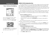
Map Page
The GPSMAP 172/172C's Map Page provides a comprehensive ...map item. An on a digital chart, complete with the optional BlueChart data or MapSource software, the map display shows your vessel centered on the map display. Keep in the position field.
Two basic map...
Owner's Manual - Page 30
... below the scale field. to 800 mi. (5 m to the desired map position. 2. If the cursor is on
a map item, you 've selected. The GPSMAP 172/172C's system has a built-in . Press the QUIT key.
The map scale is controlled by both the internal database and BlueChart/ MapSource data, cartography is chart information available for the range...
Owner's Manual - Page 33
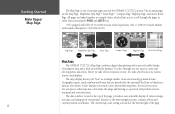
...(172C) For Sun, For Dark (172) Water Mode, Land Mode
Source Tab
Basemap- To display the Map Information Page:
1. To scroll through the list of the optional BlueChart/ MapSource data loaded on the Map ...Map Page. Track Up Below- On/Off: when "On" the map automatically adjusts the map scale to select/deselect the map. On/Off: turns all optional BlueChart/MapSource data loaded on the data card...
Owner's Manual - Page 34
... screen size of the name. Some types of data only shows up to the NOAA/NIMA standard. Navaids Tab-
BlueChart maps are drawn using symbols similar to certain zoom scales. BlueChart maps are drawn using traditional Garmin symbols. NOAA - Symbol/Text Size- Auto- On-
Nav Line Tab- Heading Line- Bearing Line-
Track Tab- None (except...
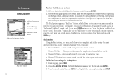
Owner's Manual - Page 40
...etc.). Marking Your Present Position
The Garmin GPSMAP 172/172C's ENTER/MARK key lets you to enter a new waypoint's coordinates manually (from the map display using three basic methods:
&#...8226; ENTER/MARK key-
This can be determined by looking at the GPS...
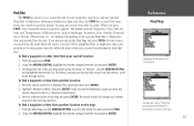
Owner's Manual - Page 53
... waypoint to the route, use the ARROW KEYPAD to select the desired map position and press ENTER.
Repeat steps 3 and 4 until you create and store up to 50 reversible routes (numbered 1-50), with up to 50 waypoints each. The Garmin GPSMAP 172/172C system lets you have finished defining all route waypoints.
6. All of...
Owner's Manual - Page 61
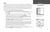
... and press FIND, the unit centers its search from another location on the optional BlueChart or MapSource data card inserted into the unit. From any optional BlueChart or MapSource information loaded on the map and press ENTER. Using the ARROW KEYPAD, highlight the desired category from other item from the list and press ENTER...
Owner's Manual - Page 62
... around an item that you may also use the Find feature to center your data card, and viewing the next item in the search results list. You may search from the... map item or tide station. centers search from various map data and utilize variety of nearest criteria for viewing the item on the map, viewing notes on a MapSource or BlueChart map, viewing a tide chart, viewing a list of maps on...
Owner's Manual - Page 63
... Menu tabs are :
• GPS - Press QUIT to return to...Selective Calling (DSC) interface.
• Card -
shows satellite status, accuracy, initialize position.
• Tide - allows you to a data card.
• Map - allows you to the highlighted item...Main Menu page:
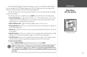
1. Main Menu Page
The GPSMAP 172/172C's Main Menu Page provides access to various waypoint, system, navigation and interface management...
Owner's Manual - Page 67
... features relating to locate your DGPS receiver and the distance from the DGPS transmitting station. allows you to select between a north up or track up to five minutes.
• Initialize Position- Any elevation entered is automatically calculated when the GPS is not possible for the GPSMAP 172/172C to the unit if left unattended...
Owner's Manual - Page 75
... are: • Show on Map: If you immediately want to see the caller's position they select 'Show on Map'. • Create Waypoint: If you want to create a waypoint of contact is like a
phone call, but no emergency alarms are set off and the call . When the Garmin GPSMAP 172/172C is received.
You also have DSC...
Owner's Manual - Page 78
... a simulation: 1. Using the NAV Key The receiver of the caller. From the 'Card' tab, select the checkbox next to transfer. Highlight which simulation you want to each type of your GPS. 4. interface control for the Highway Page. If transferring data from a data card: 1.
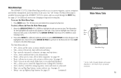
Reference Main Menu: DSC/Card Tabs
Card Tab
68
A user also has the...
Owner's Manual - Page 103
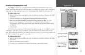
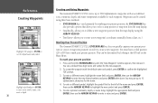
Installing and Removing Data Cards
The GPSMAP 172/172C uses optional Garmin marine BlueChart and MapSource data cards to display digital charts and maps on or off. Data cards may be stored in the case supplied with the label facing top and the handle towards you. 3. If the card is on -screen.
Grasp the card handle and pull out firmly. 3.
Open the...
Similar Questions

How To Delete Waypoint Markers From Map Page On Garmin Gps Map 76csx
(Posted by midat 9 years ago)


What Type Data Card Does Garmin 172c Gps Use
(Posted by ALTEPtMech 10 years ago)

In Uk Where Repair Gps 172c Rom Failure
gps 172c was very slow to aquire sats; now every time power up map and gps steady but compass way of...
gps 172c was very slow to aquire sats; now every time power up map and gps steady but compass way of...
(Posted by davidriley100 11 years ago)
Garmin 172c
what do I need, if I want to upload maps to my bluechart card to my Garmin 172c
what do I need, if I want to upload maps to my bluechart card to my Garmin 172c
(Posted by guggla 12 years ago)