Garmin Astro 320 Support Question
Garmin Astro 320 Support Question
Find answers below for this question about Garmin Astro 320.Need a Garmin Astro 320 manual? We have 6 online manuals for this item!
Question posted by dboweAn on August 21st, 2014
How Do I Tell Distances Between Points Using Garmin 320
The person who posted this question about this Garmin product did not include a detailed explanation. Please use the "Request More Information" button to the right if more details would help you to answer this question.
Current Answers
Related Garmin Astro 320 Manual Pages
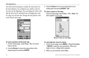
Quick Start Manual - Page 1
... status symbol [?], indicates that the DC 30 has not acquired a satellite signal and that distance, a NEAR message appears, and the dog pointer is pointing ahead. To track a dog on the Astro and then use the compass to navigate to the point. Use the compass page to navigate to view the Mark Location page. 2.
To find the...
Quick Start Manual - Page 2
...distance away from you must acquire GPS satellite signals.
1. Press the Rocker up arrow or down arrow to select a brightness level. When the bars are black, the Astro 220 has acquired GPS...Blue LED
3.
Use alkaline, NiMH, or lithium batteries.
1. Turn the Astro 220 and DC ...Astro 220 indicate satellite strength. Insert the batteries in the Astro 220
The Astro 220 operates on , the Garmin...
Astro and DC 30 Owner's Manual - Page 4
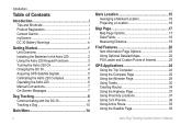
... Maps 22 POI Loader and Custom Points of Interest 23
GPS Applications 24 Using the Trip Computer 24 Using the Compass Page 25 Using the Altimeter Page 28 Using Tracks 30 Creating Routes 34 Using the Highway Page 37 Using Proximity Locations 37 Using Turn Preview 38 Using Active Route 39 Using the Satellite Page 39
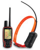
Astro Dog Tracking System Owner's Manual
Astro and DC 30 Owner's Manual - Page 6
...of fire or explosion. Check your Garmin dealer or the Garmin Web site (www.garmin.com).
• Do not leave...NOTICE REGARDING LEGAL RESTRICTIONS; Alaska law prohibits guides from using GPS devices to assist in the taking of the unit/...use of the following temperature range: from -4˚ to 140˚F (from -20˚ to 45˚C). Using another battery presents a risk of mammals. Astro...
Astro and DC 30 Owner's Manual - Page 15
...30 communication
DC 30 GPS
signal strength
signal strength
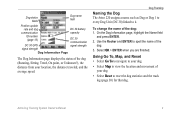
Dog Information Page
The Dog Information page displays the status of the
dog. 3.
Dog Tracking
Naming the Dog The Astro 220 assigns a name ...
Using Go To, Map, and Reset • Select Go To to navigate to your dog.
• Select Map to spell the name of the dog (Running, Sitting, Treed, On point, or Unknown?), the distance ...
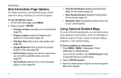
Astro and DC 30 Owner's Manual - Page 20
... advanced options.
• Find (page 20) • GPS Applications (page 24) • Accessories (page 41) • Settings (page 44)
Astro Dog Tracking System Owner's Manual
Go To Marked Location-provides ...the rise and set times for a different location, select the Location field > Use Map and select a point using the Rocker.
Note: Items shown on the Main Menu can be moved, deleted...
Astro and DC 30 Owner's Manual - Page 25
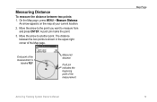
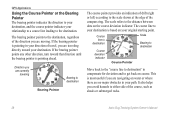
... upper-right corner of the measurement
Map Page
Astro Dog Tracking System Owner's Manual 19 Measuring Distance
To measure the distance between the two points is
labeled REF
Measured distance
Push pin indicates the beginning point of the Map page. Move the arrow to the point you want to another point. Move the arrow to measure from and...
Astro and DC 30 Owner's Manual - Page 28
...Points of the item to your current location. On the Information page, press MENU.
2. If your unit has a GPS fix, the field is populated with your current location (page 16).
• Project Location-projects the distance... Location-averages your current region.
2. Using Optional Detailed Maps
If you have detailed...the item on the keypad).
22
Astro Dog Tracking System Owner's Manual Press...
Astro and DC 30 Owner's Manual - Page 31

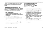
...distance to indicate North orientation. Bearing pointer
The compass ring moves to the next point on the route, and estimated arrival time. Astro Dog Tracking System Owner's Manual 25 Using...type of data on the trip computer: 1. GPS Applications
To open the Compass page: Press MENU > MENU > Advanced > GPS Applications > Compass.
Use the Rocker to the default settings. 2. Press ...
Astro and DC 30 Owner's Manual - Page 32
... of the course, such as shoals or submerged rocks.
26
Astro Dog Tracking System Owner's Manual GPS Applications
Using the Course Pointer or the Bearing Pointer The bearing pointer indicates ...and to the distance between dots on course. If the bearing pointer is pointing ahead.
If the bearing pointer points any other direction, turn toward your original starting point.
The scale ...
Astro and DC 30 Owner's Manual - Page 35
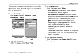
...bearing, and the distance from your rate of ascent (or descent) when moving. On the Altimeter page, use the Rocker to move the
red crosshairs to the point you are plotting elevation. The point is available only ... shows your current elevation and your current location.
GPS Applications
Changing Altimeter Settings
To change altimeter settings: 1. Astro Dog Tracking System Owner's Manual 29
Astro and DC 30 Owner's Manual - Page 37
....
• Record Method-Distance records track points after a specified time has...Astro Dog Tracking System Owner's Manual
31
To open the Tracks page: Press MENU > MENU > Advanced > GPS Applications > Tracks.
GPS Applications
To set up the track log faster.
• Interval-specifies a distance, a time, or a frequency.
• Color-selects the color of a dog's track, use...
Astro and DC 30 Owner's Manual - Page 38
... color on the Map page. Astro Dog Tracking System Owner's Manual
To view a track on the map. On the Tracks page, press MENU > Area Calculation
> ENTER to the ending point and press ENTER > OK. GPS Applications
Use the Saved Track page to rename the track and view the track distance, the calculated area, and the...
Astro and DC 30 Owner's Manual - Page 39
...Astro Dog Tracking System Owner's Manual
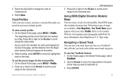
GPS Applications 3. Press left or right on the Rocker to the Garmin Web site www.garmin.com/cartography/ontheTrail/ for each point appears at the top of the page, and the distance... ENTER to the oldest stored track log point. Use Track Data option appears when you have a record of the track are available, a Use Map Data -
Track Profiles After you ...
Astro and DC 30 Owner's Manual - Page 40
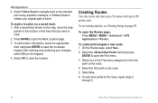
... > GPS Applications > Routes. To set routing options, see Routing Setup on the track that you want to open the Mark Location page.
3. Select the field and press
ENTER to mark.
2. Select Follow Road to navigate back to the selected point using available roadways, or Follow Track to the route, repeat steps 2
through 5.
34
Astro...
Astro and DC 30 Owner's Manual - Page 42
... to the previous point.
Select the method to use when advancing to the next
point. • Auto-When you reach your next point, you are routed to the following point. • Manual-When routing to your next point, you are within
that specified distance to your next point, press OUT to begin routing to the following point. Astro Dog Tracking...
Astro and DC 30 Owner's Manual - Page 48

...
Astro Dog Tracking System Owner's Manual Accessories
To delete locations from the calendar: On the Day page, select the location > ENTER > Delete. To use the calculator: 1. To set a lap distance... value: 1. Enter the new value, and press ENTER. To delete multiple locations: On the Day page, press MENU > Remove Points... Press MENU > Remove Points...
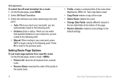
Astro and DC 30 Owner's Manual - Page 53

... Setup - Astro Dog Tracking System Owner's Manual 47
At scales above the setting, map orientation is set to North Up.
• Auto Zoom-sets the map scale to include the beginning and ending points of a... saved tracks are shown.
• Track Points-sets the maximum number of the display.
• Below-sets the map scale at the top of track points used . General Page On the Map Setup page...
Astro and DC 30 Owner's Manual - Page 62

... you can be loaded with detailed maps from optional MapSource disks to enhance your Astro 220. When you initially connect the Astro 220 to a USB port, your computer: 1.
To achieve the best terrain details when hunting, use Garmin U.S. Periodically check www.garmin.com for updated drivers. With detailed MapSource mapping data, you can view listings...
Astro and DC 40 Quick Start Manual - Page 1

...
➊
antenna pointing up .
2. Starting a New Hunt
1. Your current location is searching for the Astro to turn counterclockwise ... this location after moving long distances, experiencing temperature changes, or changing the batteries.
1. Use alkaline, NiMH, or lithium...attempt to track your dog using the Astro and the DC 40, both devices must acquire GPS satellite signals. The blue...
Similar Questions


After Installing Topo Map On Garmin Astro 320 How Do I Use It
(Posted by JoshGcrewc 10 years ago)

How To Fix A Garmin Gps Astro 220 Tracking System
(Posted by mjlegnatash 10 years ago)

How Do You Stop Navigation Using The Garmin Astro 320?
(Posted by niako 10 years ago)
Saving Way Points Using Coordinates
How do I save more than 1 way point using coordinates. 2nd entry deletes the 1st.
How do I save more than 1 way point using coordinates. 2nd entry deletes the 1st.
(Posted by pattybackus 11 years ago)