Manual - English
Page 2
...by United States copyright laws and international treaty provisions; Never rely solely on the Magellan eXplorist while driving. Government, which you must treat the SOFTWARE like buildings and large ...aid, but does not replace the need for navigating. government and is subject to GPS satellites made by poor satellite geometry and obstructions, like any changes. therefore, you... copy, modify, reverse engineer or transfer this guide may severely degrade performance or damage the receiver, and will void the warranty. LICENSE AGREEMENT Thales grants you, the purchaser, the right ...
...by United States copyright laws and international treaty provisions; Never rely solely on the Magellan eXplorist while driving. Government, which you must treat the SOFTWARE like buildings and large ...aid, but does not replace the need for navigating. government and is subject to GPS satellites made by poor satellite geometry and obstructions, like any changes. therefore, you... copy, modify, reverse engineer or transfer this guide may severely degrade performance or damage the receiver, and will void the warranty. LICENSE AGREEMENT Thales grants you, the purchaser, the right ...

Manual - English
Page 4
... of Contents eXplorist 210 GPS Receiver Features of the Magellan eXplorist GPS receiver: Button Descriptions: Installing the Battery Using the eXplorist 210 Going to a Destination Saving Your Position Tracing Your Steps Additional Features Starting Up Turning the eXplorist On Turning the eXplorist Off Using the eXplorist for the ... Fields Position Screen Overview Position Screen Satellite Status Screen Satellite Status Screen Overview Resetting the Trip Odometer eXplorist 210 GPS File Structure Basic File Structure File Structure Overview Using the Filing System with POIs Using the Filing ...
... of Contents eXplorist 210 GPS Receiver Features of the Magellan eXplorist GPS receiver: Button Descriptions: Installing the Battery Using the eXplorist 210 Going to a Destination Saving Your Position Tracing Your Steps Additional Features Starting Up Turning the eXplorist On Turning the eXplorist Off Using the eXplorist for the ... Fields Position Screen Overview Position Screen Satellite Status Screen Satellite Status Screen Overview Resetting the Trip Odometer eXplorist 210 GPS File Structure Basic File Structure File Structure Overview Using the Filing System with POIs Using the Filing ...
Manual - English
Page 8
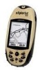
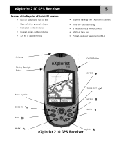
eXplorist 210 GPS Receiver Features of the Magellan eXplorist GPS receiver: • Built-in background map (8 MB) • High-definition grayscale display • Preloaded points of interest • Rugged design, rubber-protected • 22 MB of usable memory 5 • Superior tracking with 14 parallel channels • TrueFix™ GPS technology • 3 meter accuracy (WAAS/EGNOS) • Multiple track logs •...
eXplorist 210 GPS Receiver Features of the Magellan eXplorist GPS receiver: • Built-in background map (8 MB) • High-definition grayscale display • Preloaded points of interest • Rugged design, rubber-protected • 22 MB of usable memory 5 • Superior tracking with 14 parallel channels • TrueFix™ GPS technology • 3 meter accuracy (WAAS/EGNOS) • Multiple track logs •...
Manual - English
Page 9
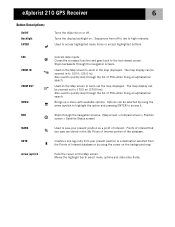
... used to quickly step through the list of POIs when doing an alphabetical search. Sequences from the Points of the database. eXplorist 210 GPS Receiver 6 Button Descriptions: On/Off Backlight ENTER Turns the eXplorist on or off to low to high intensity. Moves the highlight bar to access highlighted menu items or accept highlighted buttons...
... used to quickly step through the list of POIs when doing an alphabetical search. Sequences from the Points of the database. eXplorist 210 GPS Receiver 6 Button Descriptions: On/Off Backlight ENTER Turns the eXplorist on or off to low to high intensity. Moves the highlight bar to access highlighted menu items or accept highlighted buttons...

Manual - English
Page 10
eXplorist 210 GPS Receiver Wrist Lanyard Strap Mounting Hole Battery Door 7 Connector for external power and connection to install batteries.) eXplorist 210 GPS Receiver (back) Battery Door Fastener (Unscrew to open battery door to a personal computer.
eXplorist 210 GPS Receiver Wrist Lanyard Strap Mounting Hole Battery Door 7 Connector for external power and connection to install batteries.) eXplorist 210 GPS Receiver (back) Battery Door Fastener (Unscrew to open battery door to a personal computer.
Manual - English
Page 11
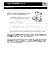
... as shown in the accompanying diagram. Press ENTER. Setting the Light Timer From any Nav screen press MENU. Press ENTER. eXplorist 210 GPS Receiver 8 Installing the Battery The eXplorist 210 uses two AA batteries that the display backlight will notice a drastic drop in use of the buttons have been pressed and... you are not moving or standing still, the eXplorist is the use . Be sure to highlight the Light Timer field. Use ...
... as shown in the accompanying diagram. Press ENTER. Setting the Light Timer From any Nav screen press MENU. Press ENTER. eXplorist 210 GPS Receiver 8 Installing the Battery The eXplorist 210 uses two AA batteries that the display backlight will notice a drastic drop in use of the buttons have been pressed and... you are not moving or standing still, the eXplorist is the use . Be sure to highlight the Light Timer field. Use ...

Manual - English
Page 12
... to your computer and select the "Explore" option. On your personal computer). eXplorist 210 GPS Receiver 9 Connecting to a Personal Computer (requires optional USB cable) Turn your eXplorist off and connect the round connector of the eXplorist data cable to the back of your eXplorist. Right click the "My Computer" icon on the connector to make sure that...
... to your computer and select the "Explore" option. On your personal computer). eXplorist 210 GPS Receiver 9 Connecting to a Personal Computer (requires optional USB cable) Turn your eXplorist off and connect the round connector of the eXplorist data cable to the back of your eXplorist. Right click the "My Computer" icon on the connector to make sure that...

Manual - English
Page 13
...three satellites with good signal strength (indicated by large obstructions (such as a straight line from the satellites. Using the eXplorist 210 10 The eXplorist 210 uses information from the GPS satellites orbiting the earth to provide you need at least four satellites with good signal strength. This is not being blocked...exact location. Do: • Point the antenna up towards the sky. • Maintain a clear view of the sky so that it can receive the signals from where you want to view the status of your hand or other objects. • Point the antenna down. • Stand ...
...three satellites with good signal strength (indicated by large obstructions (such as a straight line from the satellites. Using the eXplorist 210 10 The eXplorist 210 uses information from the GPS satellites orbiting the earth to provide you need at least four satellites with good signal strength. This is not being blocked...exact location. Do: • Point the antenna up towards the sky. • Maintain a clear view of the sky so that it can receive the signals from where you want to view the status of your hand or other objects. • Point the antenna down. • Stand ...
Manual - English
Page 33
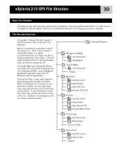
...associated main topic folder. The Detail Maps and Geocaches folders are empty until you upload a detailed map from mapping software, such as Magellan MapSend or geocache files from using any text editor and modify them to access the file. This will make finding the POI or... of the file. eXplorist 210 GPS File Structure 30 Basic File Structure The eXplorist has a file structure system that is unlike any other filing system used before on the file system that you are probably familiar with from the Magellan Geocaching software. While it is based on a GPS receiver. If you are ...
...associated main topic folder. The Detail Maps and Geocaches folders are empty until you upload a detailed map from mapping software, such as Magellan MapSend or geocache files from using any text editor and modify them to access the file. This will make finding the POI or... of the file. eXplorist 210 GPS File Structure 30 Basic File Structure The eXplorist has a file structure system that is unlike any other filing system used before on the file system that you are probably familiar with from the Magellan Geocaching software. While it is based on a GPS receiver. If you are ...

Manual - English
Page 47
... to D and so on. (Using the term multi-leg is somewhat misleading as they are erased when the eXplorist is no harder then pressing the GOTO button and searching in the Cursor mode of a GPS receiver. Routes 44 Routes are the least understood and one -leg route with a starting point (your present position...
... to D and so on. (Using the term multi-leg is somewhat misleading as they are erased when the eXplorist is no harder then pressing the GOTO button and searching in the Cursor mode of a GPS receiver. Routes 44 Routes are the least understood and one -leg route with a starting point (your present position...
Manual - English
Page 75
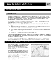
... includes street maps for driving, topographic maps for hiking, camping, and hunting, and fresh/salt water maps for use on -line www.magellangps.com under Products > Maps and Software. Please refer to install the software onto your eXplorist into an amazingly powerful solution for the region. ...as the ability to easily create and store POIs, routes, map regions, etc. • Plug and play in the eXplorist, but are basic guidelines for Magellan hand-held GPS receivers. Using the Draw New Region tool, define the region. Notice that not all MapSend products will be uploaded and saved...
... includes street maps for driving, topographic maps for hiking, camping, and hunting, and fresh/salt water maps for use on -line www.magellangps.com under Products > Maps and Software. Please refer to install the software onto your eXplorist into an amazingly powerful solution for the region. ...as the ability to easily create and store POIs, routes, map regions, etc. • Plug and play in the eXplorist, but are basic guidelines for Magellan hand-held GPS receivers. Using the Draw New Region tool, define the region. Notice that not all MapSend products will be uploaded and saved...
Manual - English
Page 78
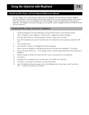
Under "Programs" select 'Magellan > eXplorist 210 > Magellan Conversion Manager'. 3. In the example shown, files are being transferred from the eXplorist to MapSend). Browse through the folders and select the POI, route or track log files to conclude...Access the Magellan Conversion Manager by using the Magellan Conversion Manager. Click Next >. 11. Using the eXplorist with your eXplorist.) Transferring POIs, Routes, and Tracks to MapSend 1. Since the eXplorist stores these data items in a more accessible manner than previous GPS receivers, you must use the Magellan Conversion Manager...
Under "Programs" select 'Magellan > eXplorist 210 > Magellan Conversion Manager'. 3. In the example shown, files are being transferred from the eXplorist to MapSend). Browse through the folders and select the POI, route or track log files to conclude...Access the Magellan Conversion Manager by using the Magellan Conversion Manager. Click Next >. 11. Using the eXplorist with your eXplorist.) Transferring POIs, Routes, and Tracks to MapSend 1. Since the eXplorist stores these data items in a more accessible manner than previous GPS receivers, you must use the Magellan Conversion Manager...

Manual - English
Page 80
... approximate location and uses this last position fix when doing its approximate position, long time GPS receiver users will still be overhead. Restarting the GPS Restarting the GPS provides a means of how the eXplorist works will be able to compute your usage and needs. Every time you would use... the units of measure for information displayed. • A means to set alarms to alert you when you have lost GPS signal, when you turn your eXplorist. • Choose from ten different languages that can be helpful. This process can appear as initializing. To understand when you...
... approximate location and uses this last position fix when doing its approximate position, long time GPS receiver users will still be overhead. Restarting the GPS Restarting the GPS provides a means of how the eXplorist works will be able to compute your usage and needs. Every time you would use... the units of measure for information displayed. • A means to set alarms to alert you when you have lost GPS signal, when you turn your eXplorist. • Choose from ten different languages that can be helpful. This process can appear as initializing. To understand when you...

Manual - English
Page 91
... To adjust the time you must first select a format that you want to highlight the alarm field that the time will be displayed in the GPS satellite and is set . 7. Press ENTER. 4. Press ENTER. 6. With the clock field highlighted, press ENTER. 11. Use the Arrow joystick to ...Preferences. 3. Use the Arrow joystick to turn off the alarm. Press MENU. 2. Press ENTER. left/right moves the cursor.) 12. The eXplorist receives its clock information from the list of available distances the distance that you want the alarm alert to come on or select Off to highlight...
... To adjust the time you must first select a format that you want to highlight the alarm field that the time will be displayed in the GPS satellite and is set . 7. Press ENTER. 4. Press ENTER. 6. With the clock field highlighted, press ENTER. 11. Use the Arrow joystick to ...Preferences. 3. Use the Arrow joystick to turn off the alarm. Press MENU. 2. Press ENTER. left/right moves the cursor.) 12. The eXplorist receives its clock information from the list of available distances the distance that you want the alarm alert to come on or select Off to highlight...
User Manual
Page 1
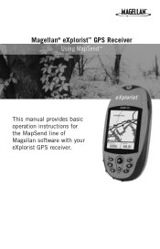
Magellan® eXplorist™ GPS Receiver Using MapSend™ This manual provides basic operation instructions for the MapSend line of Magellan software with your eXplorist GPS receiver.
Magellan® eXplorist™ GPS Receiver Using MapSend™ This manual provides basic operation instructions for the MapSend line of Magellan software with your eXplorist GPS receiver.
User Manual
Page 3
... easily create and store lots of map data that could be uploaded into an amazingly powerful solution for Magellan hand-held GPS receivers. Using MapSend maps with eXplorist The Magellan eXplorist uses a USB port to transfer data, and provides a file management system much more about the growing... cards. • Plug and play in the eXplorist, but are limited in the eXplorist. Using MapSend What is the Magellan line of performance limitations. The core MapSend product line includes street maps for driving, topographic maps for hiking, camping, and hunting, and fresh and salt...
... easily create and store lots of map data that could be uploaded into an amazingly powerful solution for Magellan hand-held GPS receivers. Using MapSend maps with eXplorist The Magellan eXplorist uses a USB port to transfer data, and provides a file management system much more about the growing... cards. • Plug and play in the eXplorist, but are limited in the eXplorist. Using MapSend What is the Magellan line of performance limitations. The core MapSend product line includes street maps for driving, topographic maps for hiking, camping, and hunting, and fresh and salt...
User Manual
Page 4
... memory, but with maps Before you get started, you may want to your eXplorist, MapSend PC applications work the same way for eXplorist as for your Magellan dealer or from any other compatible Magellan GPS receivers. It is possible to store small maps to type in this dialog box: Disregard the ..."Settings" and "Connect" options. Do not choose "Upload to GPS Unit" or "Upload to upload...
... memory, but with maps Before you get started, you may want to your eXplorist, MapSend PC applications work the same way for eXplorist as for your Magellan dealer or from any other compatible Magellan GPS receivers. It is possible to store small maps to type in this dialog box: Disregard the ..."Settings" and "Connect" options. Do not choose "Upload to GPS Unit" or "Upload to upload...


