
Triton User Manual Addendum - English, French, Spanish
Page 1
...top of the screen. Scroll down the contextual menu and select "View Area Calculation". From any navigational screen press ENTER. Triton 300 Triton 400 Triton 500 Triton 1500 Triton 2000 01.90.00.0279 01.74.00.0278 01.92.00.0283 01.53.00.0134 01.68.00.0138 The... update you can pause and then resume recording your "footsteps". The Triton receiver can calculate the perimeter and area of the space defined by pressing the MENU button. Triton User Manual Addendum This addendum applies to Triton GPS receivers that have a software version that you can now access the Main Menu...
...top of the screen. Scroll down the contextual menu and select "View Area Calculation". From any navigational screen press ENTER. Triton 300 Triton 400 Triton 500 Triton 1500 Triton 2000 01.90.00.0279 01.74.00.0278 01.92.00.0283 01.53.00.0134 01.68.00.0138 The... update you can pause and then resume recording your "footsteps". The Triton receiver can calculate the perimeter and area of the space defined by pressing the MENU button. Triton User Manual Addendum This addendum applies to Triton GPS receivers that have a software version that you can now access the Main Menu...

Triton User Manual Addendum - English, French, Spanish
Page 2
... the route is set as the coordinate system. Select View > Settings > Navigation. User Defined Map Datum. (Advanced Users) You can tell the Triton to go to the next destination (C) and repeat the process to go to define its parameters. When selecting a user datum, you are already close... to waypoint D and wish to go there instead of the receiver is disabled and the screen is activated it to go to a previous destination, in your Triton. To turn the feature off and resume computing GPS position information, go to E. To view a custom position, step through the...
... the route is set as the coordinate system. Select View > Settings > Navigation. User Defined Map Datum. (Advanced Users) You can tell the Triton to go to the next destination (C) and repeat the process to go to define its parameters. When selecting a user datum, you are already close... to waypoint D and wish to go there instead of the receiver is disabled and the screen is activated it to go to a previous destination, in your Triton. To turn the feature off and resume computing GPS position information, go to E. To view a custom position, step through the...
Manual - English
Page 2
USE CARE The Global Positioning System (GPS) is operated by the U.S. government and is subject to a complete stop or ask a passenger make any changes. IMPORTANT SAFETY WARNINGS The Magellan Triton is a navigation aid designed to assist you or others : IN THE INTERESTS OF SAFETY, DO NOT USE THIS ... accident in injury or death to GPS satellites made by the U.S. the use without the prior written permission of this guide may severely degrade performance or damage the receiver, and will void the warranty. USE PROPER ACCESSORIES Use only Magellan cables and antennas; No part of...
USE CARE The Global Positioning System (GPS) is operated by the U.S. government and is subject to a complete stop or ask a passenger make any changes. IMPORTANT SAFETY WARNINGS The Magellan Triton is a navigation aid designed to assist you or others : IN THE INTERESTS OF SAFETY, DO NOT USE THIS ... accident in injury or death to GPS satellites made by the U.S. the use without the prior written permission of this guide may severely degrade performance or damage the receiver, and will void the warranty. USE PROPER ACCESSORIES Use only Magellan cables and antennas; No part of...

Manual - English
Page 9
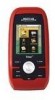
...Overview 1 Get accurate compass readings while standing still, even without a GPS fix, and no matter how you hold the receiver. (GPS receivers without an electronic compass require that you for your correct heading.) Barometer (Triton 500 only) - Sensitive barometric pressure readings offer advanced notice of the Wide...software updates and new features as feature-packed National Geographic maps from an SD card that can be kept informed of the Magellan Triton GPS receiver. Ability to upload detailed maps and store media. Be sure to be installed in map - A built-in Europe may...
...Overview 1 Get accurate compass readings while standing still, even without a GPS fix, and no matter how you hold the receiver. (GPS receivers without an electronic compass require that you for your correct heading.) Barometer (Triton 500 only) - Sensitive barometric pressure readings offer advanced notice of the Wide...software updates and new features as feature-packed National Geographic maps from an SD card that can be kept informed of the Magellan Triton GPS receiver. Ability to upload detailed maps and store media. Be sure to be installed in map - A built-in Europe may...

Manual - English
Page 11
POWER Source Battery Life Two AA Batteries (not included) Up to 5 meters (10 - 16 feet) - GPS only English, French, German, Dutch, Danish, Swedish, Spanish, Italian, Portuguese, Finnish, Norwegian Latitude/Longitude, UTM, OSGB, Irish, Swish, Swedish, Finnish, German, French,... water-resistant seal, IPX-7 Built-in multidirectional patch Nine direct-access keys 14° to 140°F (-10° to 60°C) PERFORMANCE Receiver Acquisition Time Update Rate Accuracy Languages Coordinate Systems SiRF Star III™ 20 channels, WAAS/EGNOS Hot: 20 seconds, Cold: 60 seconds, Initial: ...
POWER Source Battery Life Two AA Batteries (not included) Up to 5 meters (10 - 16 feet) - GPS only English, French, German, Dutch, Danish, Swedish, Spanish, Italian, Portuguese, Finnish, Norwegian Latitude/Longitude, UTM, OSGB, Irish, Swish, Swedish, Finnish, German, French,... water-resistant seal, IPX-7 Built-in multidirectional patch Nine direct-access keys 14° to 140°F (-10° to 60°C) PERFORMANCE Receiver Acquisition Time Update Rate Accuracy Languages Coordinate Systems SiRF Star III™ 20 channels, WAAS/EGNOS Hot: 20 seconds, Cold: 60 seconds, Initial: ...
Manual - English
Page 12
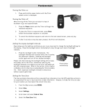
... before the shutdown sequence is reduced as not to be computed from information from the GPS satellites so there is no key has been pressed, the Triton will increase 20% until the Triton splash screen is so slight so as battery capacity gets lower. Press the backlight button...To cancel the shutdown sequence and return to step through each level of backlight intensity. 1. If after 5 seconds no requirement for the Triton. The backlight intensity will shutdown. Press button momentarily Setting the Time Zone The time and date information will be noticeable yet will turn ...
... before the shutdown sequence is reduced as not to be computed from information from the GPS satellites so there is no key has been pressed, the Triton will increase 20% until the Triton splash screen is so slight so as battery capacity gets lower. Press the backlight button...To cancel the shutdown sequence and return to step through each level of backlight intensity. 1. If after 5 seconds no requirement for the Triton. The backlight intensity will shutdown. Press button momentarily Setting the Time Zone The time and date information will be noticeable yet will turn ...
Manual - English
Page 17
... cursor control, highlight the Backlight Level slider. Disable the electronic compass if GPS fix is available. (Magellan Triton 500) 1. Select Settings. 4. Select Volume & Brightness. 5. Press MENU. 2. Select View. 3. Select Volume & Brightness. 5. Press MENU. 2. Select View. Select Settings. 4. Use the left side of the receiver) to a lower level. Battery Life The following are things you can...
... cursor control, highlight the Backlight Level slider. Disable the electronic compass if GPS fix is available. (Magellan Triton 500) 1. Select Settings. 4. Select Volume & Brightness. 5. Press MENU. 2. Select View. 3. Select Volume & Brightness. 5. Press MENU. 2. Select View. Select Settings. 4. Use the left side of the receiver) to a lower level. Battery Life The following are things you can...
Manual - English
Page 24
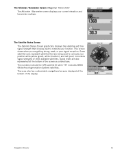
This screen shows when you are being used to compute your location. The numbers indicate the GPS satellite ID while "W" indicates WAAS (Wide Area Augmentation System) satellites. The Altimeter / Barometer Screen (Magellan Triton 500) The Altimeter / Barometer screen displays your position while yellow (good), white (medium), and red (poor) icons show signal strengths of other...
This screen shows when you are being used to compute your location. The numbers indicate the GPS satellite ID while "W" indicates WAAS (Wide Area Augmentation System) satellites. The Altimeter / Barometer Screen (Magellan Triton 500) The Altimeter / Barometer screen displays your position while yellow (good), white (medium), and red (poor) icons show signal strengths of other...
Manual - English
Page 26
... arrive at a destination. This may decrease the accuracy (increase the number) such as heavy canopies from trees, tunnels, tall buildings, canyons, broadcast satellites, and other GPS receivers too close in distance) the progress the user has made . Normally the accuracy is traveling directly towards the destination point the number should match the...
... arrive at a destination. This may decrease the accuracy (increase the number) such as heavy canopies from trees, tunnels, tall buildings, canyons, broadcast satellites, and other GPS receivers too close in distance) the progress the user has made . Normally the accuracy is traveling directly towards the destination point the number should match the...

Manual - English
Page 27
... of sight to the destination from current location.) Track (Displays previous travel.) Trail (Track that has been saved in the receiver.) Start Flag (Indicates the starting point of the active route.) End Flag (Indicates the ending point of the active route.)...GPS Signal Strength North Indicator Data Fields Map Scale Pan Mode Map Legend Present Position Cursor (Points in the direction of waypoints saved in the Magellan Triton and it has a special contextual menu that can be performed directly from the Waypoint Information screen.) Map Screen 19 Red dot points towards your receiver...
... of sight to the destination from current location.) Track (Displays previous travel.) Trail (Track that has been saved in the receiver.) Start Flag (Indicates the starting point of the active route.) End Flag (Indicates the ending point of the active route.)...GPS Signal Strength North Indicator Data Fields Map Scale Pan Mode Map Legend Present Position Cursor (Points in the direction of waypoints saved in the Magellan Triton and it has a special contextual menu that can be performed directly from the Waypoint Information screen.) Map Screen 19 Red dot points towards your receiver...
Manual - English
Page 37
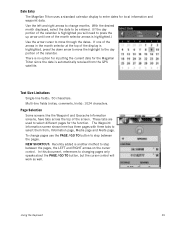
... current date for the Magellan Triton since the date is another method to select them from the GPS satellite. Text Size Limitations Single-line fields: 50 characters. Multi-line fields (notes, comments, hints): 1024 characters. NEW SHORTCUT: Recently added is automatically received from ; The Waypoint ... displayed, select the date to step between the pages, the LEFT and RIGHT arrows on the cursor control. Date Entry The Magellan Triton uses a standard calendar display to select different pages for the function. Use the left and right arrows to change pages use ...
... current date for the Magellan Triton since the date is another method to select them from the GPS satellite. Text Size Limitations Single-line fields: 50 characters. Multi-line fields (notes, comments, hints): 1024 characters. NEW SHORTCUT: Recently added is automatically received from ; The Waypoint ... displayed, select the date to step between the pages, the LEFT and RIGHT arrows on the cursor control. Date Entry The Magellan Triton uses a standard calendar display to select different pages for the function. Use the left and right arrows to change pages use ...
Manual - English
Page 39
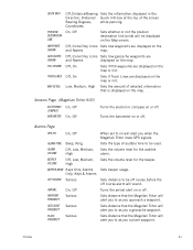
... the map or not. Sets distance to be off course before the off . Turns the arrival alert on the Map screen. Sensors Page (Magellan Triton 500) ELECTRONIC COMPASS BAROMETER On, Off On, Off Turns the electronic compass on or off course alarm will alert you to on will be displayed... how waypoints are and Names displayed on the map. Alarms Page GPS FIX On, Off ALARM TONE ALARM VOLUME BEEPER VOLUME Beep, Ring Off, Low, Medium, High Off, Low, Medium, High When set to as you when the Magellan Triton loses GPS signals. Sets distance that is displayed on the map.
... the map or not. Sets distance to be off course before the off . Turns the arrival alert on the Map screen. Sensors Page (Magellan Triton 500) ELECTRONIC COMPASS BAROMETER On, Off On, Off Turns the electronic compass on or off course alarm will alert you to on will be displayed... how waypoints are and Names displayed on the map. Alarms Page GPS FIX On, Off ALARM TONE ALARM VOLUME BEEPER VOLUME Beep, Ring Off, Low, Medium, High Off, Low, Medium, High When set to as you when the Magellan Triton loses GPS signals. Sets distance that is displayed on the map.

Manual - English
Page 50
...and the name of Geocaching.com can transfer.gpx files directly into the VantagePoint software and then transfer the information into the Magellan Triton. From the Map screen, press MENU. 2. For additional information on Map or Coordinates. (If you are entering waypoint .... 7. Select Create. 3. People will have hints and descriptions included to help in the Triton. 8. Geocache information includes Difficulty (1 through 5 with 5 being the most difficult), Terrain (1 though 5 with GPS users. Select the the waypoint. Select Go To. icon to the Information page. Press...
...and the name of Geocaching.com can transfer.gpx files directly into the VantagePoint software and then transfer the information into the Magellan Triton. From the Map screen, press MENU. 2. For additional information on Map or Coordinates. (If you are entering waypoint .... 7. Select Create. 3. People will have hints and descriptions included to help in the Triton. 8. Geocache information includes Difficulty (1 through 5 with 5 being the most difficult), Terrain (1 though 5 with GPS users. Select the the waypoint. Select Go To. icon to the Information page. Press...
Manual - English
Page 61
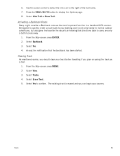
... name. 7. Select View. 3. Select Tracks. 4. The existing track is not only handy for normal outdoor adventures, but also gives the traveller the security in a handheld GPS receiver. Select Erase Track. 5. Press the PAGE / GO TO button to confirm. Use the cursor control to select the info icon to your journey. 6.
... name. 7. Select View. 3. Select Tracks. 4. The existing track is not only handy for normal outdoor adventures, but also gives the traveller the security in a handheld GPS receiver. Select Erase Track. 5. Press the PAGE / GO TO button to confirm. Use the cursor control to select the info icon to your journey. 6.


