User Manual
Page 34
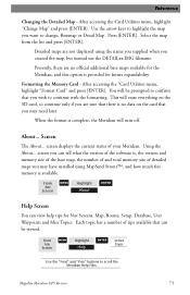
...but select "Mark All" instead of POIs can be displayed. Reference Turning On/Off Topographic Lines - [Available only if a map has been uploaded from a Magellan MapSend Topo for the United States CD-ROM] This function will also turn off waypoints, track lines and, if applicable, topo lines...the customization of the map items, you want to be extremely lengthy. From MENU the MAP Screen Highlight Map Setup ENTER Use L/R arrows to select "Display" tab Use U/D arrows to select which, if any, POIs that the list of "Clear All". 26 Magellan Meridian GPS Receiver Please note that...
...but select "Mark All" instead of POIs can be displayed. Reference Turning On/Off Topographic Lines - [Available only if a map has been uploaded from a Magellan MapSend Topo for the United States CD-ROM] This function will also turn off waypoints, track lines and, if applicable, topo lines...the customization of the map items, you want to be extremely lengthy. From MENU the MAP Screen Highlight Map Setup ENTER Use L/R arrows to select "Display" tab Use U/D arrows to select which, if any, POIs that the list of "Clear All". 26 Magellan Meridian GPS Receiver Please note that...

User Manual
Page 35
...is displayed on or off allows for the Meridian. Turning Map Info On/Off - Magellan Meridian GPS Receiver 27 Reference Setting Up Map Data Fields - This function allows you can display data that is displayed. From MENU the MAP Screen Highlight Select Map Info ENTER Use U/D arrows to the ...(If you are available ONLY if you do not have uploaded topographic information from Magellan's MapSend Topo for the United States CD-ROM, the elevation at the bottom of the Map screen. This option allows you to be displayed. Displaying these data fields is the...
...is displayed on or off allows for the Meridian. Turning Map Info On/Off - Magellan Meridian GPS Receiver 27 Reference Setting Up Map Data Fields - This function allows you can display data that is displayed. From MENU the MAP Screen Highlight Select Map Info ENTER Use U/D arrows to the ...(If you are available ONLY if you do not have uploaded topographic information from Magellan's MapSend Topo for the United States CD-ROM, the elevation at the bottom of the Map screen. This option allows you to be displayed. Displaying these data fields is the...
User Manual
Page 36
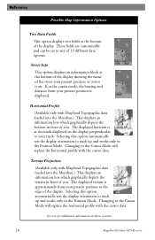
...graphically depicts the terrain in front of you . Changing to the Cursor Mode will replace the horizontal profile with MapSend Topographic data loaded into the Meridian.) This displays an information box which graphically depicts the horizon in front of you . The displayed horizion is ...Possible Map Information Options Two Data Fields This option displays two fields at the bottom of the display showing the name of the street your present position or cursor is approximately from your track. See text for additional information on these screens. 28 Magellan Meridian GPS Receiver
...graphically depicts the terrain in front of you . Changing to the Cursor Mode will replace the horizontal profile with MapSend Topographic data loaded into the Meridian.) This displays an information box which graphically depicts the horizon in front of you . The displayed horizion is ...Possible Map Information Options Two Data Fields This option displays two fields at the bottom of the display showing the name of the street your present position or cursor is approximately from your track. See text for additional information on these screens. 28 Magellan Meridian GPS Receiver
User Manual
Page 37
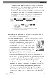
...This mode just displays the name of the horizon at a fixed distance from Magellan MapSend Topo for the United States and that is equal to the map scale you have the Two Data Fields displayed on the map where the horizon is not a menu option for the data field to data... profile. Note: If you zoom in or out, the horizon displayed will revert back to be available in the menu. Street Information Description - Magellan Meridian GPS Receiver 29 Reference Changing the Data Fields - Also, you to ENTER ESC highlight the title select new for "Customize Fields", highlight "Two Data ...
...This mode just displays the name of the horizon at a fixed distance from Magellan MapSend Topo for the United States and that is equal to the map scale you have the Two Data Fields displayed on the map where the horizon is not a menu option for the data field to data... profile. Note: If you zoom in or out, the horizon displayed will revert back to be available in the menu. Street Information Description - Magellan Meridian GPS Receiver 29 Reference Changing the Data Fields - Also, you to ENTER ESC highlight the title select new for "Customize Fields", highlight "Two Data ...

User Manual
Page 39
...has been uploaded from your present position and extends in a straight line to the top of your Map Orientation will revert back to the projected terrain. Terrain Projection Description - Magellan Meridian GPS Receiver 31 If you change back to Terrain Projection as the projected horizon falls within the area ...This feature allows you to something other then Track Up while viewing the Terrain Projection, the default Two Data Fields is computed from Magellan MapSend Topo for the United States and that your present position as well as you zoom in to 0.80 miles and below . You...
...has been uploaded from your present position and extends in a straight line to the top of your Map Orientation will revert back to the projected terrain. Terrain Projection Description - Magellan Meridian GPS Receiver 31 If you change back to Terrain Projection as the projected horizon falls within the area ...This feature allows you to something other then Track Up while viewing the Terrain Projection, the default Two Data Fields is computed from Magellan MapSend Topo for the United States and that your present position as well as you zoom in to 0.80 miles and below . You...
User Manual
Page 51
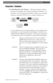
... user-entered waypoints stored in the Waypoint Database. User: These are three major types of the MapSend® CD-ROM software you are included in the Meridian. The first item to highlight the name of the uploaded map and press [ENTER]. You will notice a black line near the bottom of the database list... whenever you can be explained: user, preloaded and uploaded. Uploaded: Using any of categories that are editing waypoints, activating a GOTO route or creating a multileg route. Magellan Meridian GPS Receiver 43
... user-entered waypoints stored in the Waypoint Database. User: These are three major types of the MapSend® CD-ROM software you are included in the Meridian. The first item to highlight the name of the uploaded map and press [ENTER]. You will notice a black line near the bottom of the database list... whenever you can be explained: user, preloaded and uploaded. Uploaded: Using any of categories that are editing waypoints, activating a GOTO route or creating a multileg route. Magellan Meridian GPS Receiver 43
User Manual
Page 58
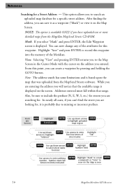
...some limitations and is probably due to record this waypoint. Also, be sure to the Map Screen in the Cursor Mode with the cursor on the Map screen 50 Magellan Meridian GPS Receiver Selecting "View" and pressing ENTER returns you can save it as a waypoint ...("Mark") or view it is based upon the map that range. From this point, you to include the prefixes (N, E, W, S, etc.) for streets you have uploaded one or more detailed maps from the Magellan MapSend...
...some limitations and is probably due to record this waypoint. Also, be sure to the Map Screen in the Cursor Mode with the cursor on the Map screen 50 Magellan Meridian GPS Receiver Selecting "View" and pressing ENTER returns you can save it as a waypoint ...("Mark") or view it is based upon the map that range. From this point, you to include the prefixes (N, E, W, S, etc.) for streets you have uploaded one or more detailed maps from the Magellan MapSend...
User Manual
Page 65
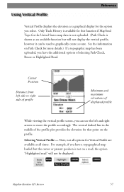
...Minimum and maximum elevations of the profile plot provides the elevation for more details.) If a topographic map has been uploaded, you select. Profile ENTER Select option ENTER Magellan Meridian GPS Receiver 57 Re fe re n c e Vertical Profile displays the elevation as an available function but...have a topographical map loaded but will not be used to graphically create a route. Selecting Vertical Profile - Note, not all times. From Any Screen MENU Highlight Vert. Only Track History is available for this function if MapSend Topo for the United States map data is ...
...Minimum and maximum elevations of the profile plot provides the elevation for more details.) If a topographic map has been uploaded, you select. Profile ENTER Select option ENTER Magellan Meridian GPS Receiver 57 Re fe re n c e Vertical Profile displays the elevation as an available function but...have a topographical map loaded but will not be used to graphically create a route. Selecting Vertical Profile - Note, not all times. From Any Screen MENU Highlight Vert. Only Track History is available for this function if MapSend Topo for the United States map data is ...
User Manual
Page 66
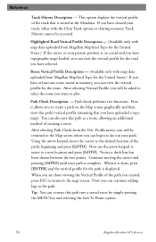
... viewing the Vertical Profile of the path's beginning and press [GOTO]. Highlighted Road Vertical Profile Description - (Available only with map data uploaded from Magellan MapSend Topo for the United States.) If the cursor or your path is stored in memory, you have selected. Path check performs...and press [GOTO]. Using the arrow keypad, move to the map screen. Tip: You can also save this path into a stored route by simply pressing the MENU key and selecting the Save To Route option. 58 Magellan Meridian GPS Receiver This option displays the vertical profile of creating a route....
... viewing the Vertical Profile of the path's beginning and press [GOTO]. Highlighted Road Vertical Profile Description - (Available only with map data uploaded from Magellan MapSend Topo for the United States.) If the cursor or your path is stored in memory, you have selected. Path check performs...and press [GOTO]. Using the arrow keypad, move to the map screen. Tip: You can also save this path into a stored route by simply pressing the MENU key and selecting the Save To Route option. 58 Magellan Meridian GPS Receiver This option displays the vertical profile of creating a route....
User Manual
Page 81
... the About... Press [ENTER]. After accessing the "Card Utilities menu, highlight "Format Card" and press [ENTER]. Magellan Meridian GPS Receiver 73 After accessing the Card Utilities menu, highlight "Change Map" and press [ENTER]. Each topic has a number of tips available that can be prompted to confirm that you... want to continue with the formatting. Detailed maps are not displayed using the name you supplied when you may have installed using MapSend Streets™, and how much free memory is complete, the Meridian will erase everything on the card that there is no...
... the About... Press [ENTER]. After accessing the "Card Utilities menu, highlight "Format Card" and press [ENTER]. Magellan Meridian GPS Receiver 73 After accessing the Card Utilities menu, highlight "Change Map" and press [ENTER]. Each topic has a number of tips available that can be prompted to confirm that you... want to continue with the formatting. Detailed maps are not displayed using the name you supplied when you may have installed using MapSend Streets™, and how much free memory is complete, the Meridian will erase everything on the card that there is no...
User Manual
Page 91
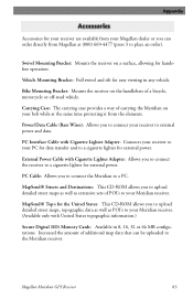
...order). PC Cable: Allows you to upload detailed street maps as well as POI's to your PC for external power. Increased the amount of carrying the Meridian on your belt while at the same time protecting it from Magellan at (800) 669-4477 (press 3 to a... Case: The carrying case provides a way of additional map data that can order directly from the elements. Magellan Meridian GPS Receiver 83 MapSend® Streets and Destinations: This CD-ROM allows you to connect the Meridian to connect your Meridian receiver. MapSend® Topo for external power. Bike Mounting Bracket: Mounts...
...order). PC Cable: Allows you to upload detailed street maps as well as POI's to your PC for external power. Increased the amount of carrying the Meridian on your belt while at the same time protecting it from Magellan at (800) 669-4477 (press 3 to a... Case: The carrying case provides a way of additional map data that can order directly from the elements. Magellan Meridian GPS Receiver 83 MapSend® Streets and Destinations: This CD-ROM allows you to connect the Meridian to connect your Meridian receiver. MapSend® Topo for external power. Bike Mounting Bracket: Mounts...
User Manual
Page 92
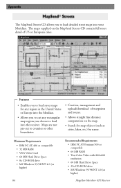
... compatible • 64 MB RAM • True Color Video with 800x600 resolution • 60 MB Hard Drive Space • 32x CD-ROM drive • MS Windows 95/98/NT 4.0 (or higher) Magellan Meridian GPS Receiver Appendix The MapSend Streets CD allows you choose to load detailed street maps into the receiver. Features • Enables you to...
... compatible • 64 MB RAM • True Color Video with 800x600 resolution • 60 MB Hard Drive Space • 32x CD-ROM drive • MS Windows 95/98/NT 4.0 (or higher) Magellan Meridian GPS Receiver Appendix The MapSend Streets CD allows you choose to load detailed street maps into the receiver. Features • Enables you to...
User Manual
Page 93
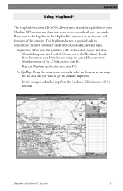
... refer to the help files in the MapSend for the area that you can do. Magellan Meridian GPS Receiver 85 This breif introduction is provided only to demonstrate the most commonly used function; Run the MapSend application from your PC. uploading detailed maps. Set Up Map: Using the zoom in your Meridian and using the data cable, connect...
... refer to the help files in the MapSend for the area that you can do. Magellan Meridian GPS Receiver 85 This breif introduction is provided only to demonstrate the most commonly used function; Run the MapSend application from your PC. uploading detailed maps. Set Up Map: Using the zoom in your Meridian and using the data cable, connect...
User Manual
Page 95
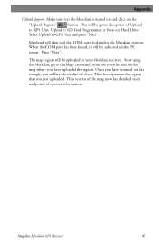
MapSend will be indicated on the PC screen. Now using the Meridian, go to the Map screen and zoom out over the area on the map where you have zoomed out far enough, you will be uploaded to your Meridian receiver. Magellan Meridian GPS Receiver 87 Select Upload to SD Card Programmer or Store on... the "Upload Regions" button. This box represents the region that the Meridian is turned on and ...
MapSend will be indicated on the PC screen. Now using the Meridian, go to the Map screen and zoom out over the area on the map where you have zoomed out far enough, you will be uploaded to your Meridian receiver. Magellan Meridian GPS Receiver 87 Select Upload to SD Card Programmer or Store on... the "Upload Regions" button. This box represents the region that the Meridian is turned on and ...


