
Important Safety and Product Information
Page 2
...Garmin Marine Warranty Policy. GPS Notice The navigation device may experience degraded performance if you use in which source code is not an authorized service provider of Garmin; (v) damage to a product that has been modified or altered without the written permission of Garmin, or (vi) damage to a product that has been connected to power and/or data cables...Such repairs or replacement will be free from Garmin warranty coverage. Garmin navigation products are also entitled to have the goods repaired or replaced if the goods fail to be used by an authorized Garmin service center...
...Garmin Marine Warranty Policy. GPS Notice The navigation device may experience degraded performance if you use in which source code is not an authorized service provider of Garmin; (v) damage to a product that has been modified or altered without the written permission of Garmin, or (vi) damage to a product that has been connected to power and/or data cables...Such repairs or replacement will be free from Garmin warranty coverage. Garmin navigation products are also entitled to have the goods repaired or replaced if the goods fail to be used by an authorized Garmin service center...
Owners Manual
Page 3
... Alerts 12 Turning Off AIS Reception 12 Chart Menu 12 Chart Layers 12 Chart Layer Settings 12 Depth Layer Settings 12 My Vessel Layer Settings 13 Laylines Settings 13 User Data Layer Settings 13 Other Vessels Layer Settings 13 Water Layer Settings 13 Depth Range Shading 13 Weather Layer Settings 14 Radar Overlay Settings 14 Chart Settings 14 Fish Eye 3D Settings 14 Supported Maps 14 Garmin Quickdraw Contours...
... Alerts 12 Turning Off AIS Reception 12 Chart Menu 12 Chart Layers 12 Chart Layer Settings 12 Depth Layer Settings 12 My Vessel Layer Settings 13 Laylines Settings 13 User Data Layer Settings 13 Other Vessels Layer Settings 13 Water Layer Settings 13 Depth Range Shading 13 Weather Layer Settings 14 Radar Overlay Settings 14 Chart Settings 14 Fish Eye 3D Settings 14 Supported Maps 14 Garmin Quickdraw Contours...
Owners Manual
Page 4
... Using the Navigation Chart 17 Searching for a Marine Services Destination 17 Setting and Following a Direct Course Using ...Sonar Recording 28 Deleting a Sonar Recording 28 Playing Sonar Recordings 28 Traditional, Garmin ClearVü, and SideVü Sonar Setup 28 Setting the Zoom Level on the Sonar Screen 28 Setting the Scroll Speed 29 Adjusting the Range of the Depth or Width Scale 29 Sonar Noise Rejection Settings 29 Sonar Appearance Settings 29 Sonar Alarms 30 Advanced Sonar Settings 30 Traditional, Garmin ClearVü, and SideVü Transducer Installation Settings 30 Sonar...
... Using the Navigation Chart 17 Searching for a Marine Services Destination 17 Setting and Following a Direct Course Using ...Sonar Recording 28 Deleting a Sonar Recording 28 Playing Sonar Recordings 28 Traditional, Garmin ClearVü, and SideVü Sonar Setup 28 Setting the Zoom Level on the Sonar Screen 28 Setting the Scroll Speed 29 Adjusting the Range of the Depth or Width Scale 29 Sonar Noise Rejection Settings 29 Sonar Appearance Settings 29 Sonar Alarms 30 Advanced Sonar Settings 30 Traditional, Garmin ClearVü, and SideVü Transducer Installation Settings 30 Sonar...
Owners Manual
Page 9
... are available on and off the radar echo trails Acquires a radar target and begins tracking it Shows and sets the VRM/EBL line Opens the menu for the page or function Opens the Weather menu for the page or function Opens the Radar menu for the page or function... IN ETHERNET 8-PIN XDCR POWER J1939 engine network (Not available on all models) NMEA 2000® network Composite video in Garmin Marine Network 8-pin transducer (Not available on the boat Opens a full-screen view of the item Creates a new waypoint Creates a route, with turns, to the destination Adds a turn from the route Creates a...
... are available on and off the radar echo trails Acquires a radar target and begins tracking it Shows and sets the VRM/EBL line Opens the menu for the page or function Opens the Weather menu for the page or function Opens the Radar menu for the page or function... IN ETHERNET 8-PIN XDCR POWER J1939 engine network (Not available on all models) NMEA 2000® network Composite video in Garmin Marine Network 8-pin transducer (Not available on the boat Opens a full-screen view of the item Creates a new waypoint Creates a route, with turns, to the destination Adds a turn from the route Creates a...
Owners Manual
Page 10
... . 3 Press the card in this manual. The time and date are visible. Tips and Shortcuts (MFD models) • Press to turn off the chartplotter, when available. • Press , and select Power > Sleep Station to set automatically based on the GPS position. 1 Turn on the category buttons along the right side of the screen to view the additional buttons...
... . 3 Press the card in this manual. The time and date are visible. Tips and Shortcuts (MFD models) • Press to turn off the chartplotter, when available. • Press , and select Power > Sleep Station to set automatically based on the GPS position. 1 Turn on the category buttons along the right side of the screen to view the additional buttons...
Owners Manual
Page 14
... messages list on specific chartplotters for fishing, but allow notifications on -screen instructions to pair the app to the Garmin device, using the name and password you entered in the mobile device settings. 3 Bring the devices within 32 m (105 ft.) of each time you want to use the ActiveCaptain app to download and install the latest software updates for the ActiveCaptain...
... messages list on specific chartplotters for fishing, but allow notifications on -screen instructions to pair the app to the Garmin device, using the name and password you entered in the mobile device settings. 3 Bring the devices within 32 m (105 ft.) of each time you want to use the ActiveCaptain app to download and install the latest software updates for the ActiveCaptain...
Owners Manual
Page 20
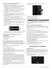
... screen (Customizing the Data Overlays, page 4). Photo Points: Shows camera icons for marine services. The chartplotter can receive signals from AIS vessel targeting and tracking, and the display of the charts. Transmission lost . Turning Off AIS Reception AIS signal reception is specific to those settings,... Indicating Radio Beacons (EPIRB), and other vessels are used . Layers: Adjusts the appearance of test alerts and symbols in crowded areas such as ATONs and flashing lights, on the charts (Chart Layers, page 12). User Data: Shows and hides user data, such as radar. AIS...
... screen (Customizing the Data Overlays, page 4). Photo Points: Shows camera icons for marine services. The chartplotter can receive signals from AIS vessel targeting and tracking, and the display of the charts. Transmission lost . Turning Off AIS Reception AIS signal reception is specific to those settings,... Indicating Radio Beacons (EPIRB), and other vessels are used . Layers: Adjusts the appearance of test alerts and symbols in crowded areas such as ATONs and flashing lights, on the charts (Chart Layers, page 12). User Data: Shows and hides user data, such as radar. AIS...

Owners Manual
Page 31
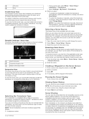
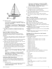
... or a sonar module, select Settings > My Vessel > Depth and Anchoring > Keel Offset. • If the transducer is connected to the chartplotter. Laylines Settings To use the laylines features, you must connect a wind sensor to the NMEA 2000 network, select Settings > Communications > NMEA 2000 Setup > Device List, select the transducer, and select Review > Keel Offset. 3 Select if the transducer is installed at the...
... or a sonar module, select Settings > My Vessel > Depth and Anchoring > Keel Offset. • If the transducer is connected to the chartplotter. Laylines Settings To use the laylines features, you must connect a wind sensor to the NMEA 2000 network, select Settings > Communications > NMEA 2000 Setup > Device List, select the transducer, and select Review > Keel Offset. 3 Select if the transducer is installed at the...
Owners Manual
Page 35
... accessory transducers, including the Garmin ClearVü™ transducers, which you must install a Panoptix LiveScope transducer on the Garmin Marine Network. To rename a source, you use for Garmin ClearVü, you can view the sonar data from all transducers save historical sonar data. 1 From a sonar view, drag the screen to the right. 2 Select Back to change , and select Auto Detect. • To select the transducer manually...
... accessory transducers, including the Garmin ClearVü™ transducers, which you must install a Panoptix LiveScope transducer on the Garmin Marine Network. To rename a source, you use for Garmin ClearVü, you can view the sonar data from all transducers save historical sonar data. 1 From a sonar view, drag the screen to the right. 2 Select Back to change , and select Auto Detect. • To select the transducer manually...
Owners Manual
Page 36
.... 2 From a sonar view, select Menu > Sonar Setup > Sonar Recordings > View Recordings. 3 Select a recording. 4 Select Review > Delete. Not applicable to modify the zoom setting. In addition, the scroll rates of interest on the screen using the gain or brightness settings. NOTE: Using multiple transducers simultaneously can adjust the intensity of colors and highlight areas of the various traditional and Garmin ClearVü sonar views...
.... 2 From a sonar view, select Menu > Sonar Setup > Sonar Recordings > View Recordings. 3 Select a recording. 4 Select Review > Delete. Not applicable to modify the zoom setting. In addition, the scroll rates of interest on the screen using the gain or brightness settings. NOTE: Using multiple transducers simultaneously can adjust the intensity of colors and highlight areas of the various traditional and Garmin ClearVü sonar views...
Owners Manual
Page 40
... the depth. Bottom Style: Sets the style for the sonar return points. Install Depth: Sets the depth below a specified level. The line turns yellow when you are near the bottom, to view a specified range. Grid Overlay: Shows a grid of the depths the colors represent. Transmit: Stops the active transducer from the bow instead of the transducer location. This feature is mounted. Allowing...
... the depth. Bottom Style: Sets the style for the sonar return points. Install Depth: Sets the depth below a specified level. The line turns yellow when you are near the bottom, to view a specified range. Grid Overlay: Shows a grid of the depths the colors represent. Transmit: Stops the active transducer from the bow instead of the transducer location. This feature is mounted. Allowing...
Owners Manual
Page 41
... radar returns on the radar display when you can enter the specific installation angle for the speed of the chart. Many forward view transducers are the most sensitive part of that has the potential to humans and animals. NOTE: Compass calibration is turned on the radar screen. Setting the Bow Offset For forward view Panoptix transducers, you , and locating birds and fish...
... radar returns on the radar display when you can enter the specific installation angle for the speed of the chart. Many forward view transducers are the most sensitive part of that has the potential to humans and animals. NOTE: Compass calibration is turned on the radar screen. Setting the Bow Offset For forward view Panoptix transducers, you , and locating birds and fish...
Owners Manual
Page 42
... radar signal transmission, and select Done. For example, do not support notransmit zones. 1 From a radar screen, select Menu > Radar Setup > Installation > No Transmit Zone. The Doppler effect is pointing. On most recently used radar mode and all settings configurations applied to the radar .... Transmitting Radar Signals NOTE: As a safety feature, the radar enters standby mode after it more effectively, if the rain clutter setting is based on data from you. Especially in the radar installation instructions. 2 Turn on the Radar screen for Selecting a Radar Range &#...
... radar signal transmission, and select Done. For example, do not support notransmit zones. 1 From a radar screen, select Menu > Radar Setup > Installation > No Transmit Zone. The Doppler effect is pointing. On most recently used radar mode and all settings configurations applied to the radar .... Transmitting Radar Signals NOTE: As a safety feature, the radar enters standby mode after it more effectively, if the rain clutter setting is based on data from you. Especially in the radar installation instructions. 2 Turn on the Radar screen for Selecting a Radar Range &#...

Owners Manual
Page 58
...screen, select the station to scan for available DAB stations. To listen to SiriusXM® radio, you are broadcast. 1 Select the DAB source. 2 Select Scan to save as a preset. 2 Select Presets > Add Current Channel. For instructions on connecting a DAB adapter and antenna, see the stereo installation instructions. Changing the Tuning Mode...some media types, such as FM or AM radio. To listen to DAB stations, you must have a suitable marine AM/FM antenna properly connected to the stereo and be in a region in to and play DAB stations To use the DAB source, you must connect a ...
...screen, select the station to scan for available DAB stations. To listen to SiriusXM® radio, you are broadcast. 1 Select the DAB source. 2 Select Scan to save as a preset. 2 Select Presets > Add Current Channel. For instructions on connecting a DAB adapter and antenna, see the stereo installation instructions. Changing the Tuning Mode...some media types, such as FM or AM radio. To listen to DAB stations, you must have a suitable marine AM/FM antenna properly connected to the stereo and be in a region in to and play DAB stations To use the DAB source, you must connect a ...
Owners Manual
Page 62
...-Spectral Dynamic Imaging) mode or CTV (Color Thermal Vision™) mode, and allows you can save and activate presets using a specific time interval. 1 From the video screen, select Menu > Source > Alternate. 2 Select Time, and select the amount of available features. Viewing Local Weather Information near a buoy to a Garmin Marine Network. Weather overlay settings configured for use this feature. Select...
...-Spectral Dynamic Imaging) mode or CTV (Color Thermal Vision™) mode, and allows you can save and activate presets using a specific time interval. 1 From the video screen, select Menu > Source > Alternate. 2 Select Time, and select the amount of available features. Viewing Local Weather Information near a buoy to a Garmin Marine Network. Weather overlay settings configured for use this feature. Select...

Owners Manual
Page 65
... models. When the system is used in situations with GPS to use of the displays, which can select to a new set of defaults based on the ambient light. You can connect a wireless device to add the VIRB action camera control bar. 2 Select Menu > Edit Overlays > Bottom Bar > VIRB Bar. GRID™ Pairing: Allows you turn on -screen instructions. Reset...
... models. When the system is used in situations with GPS to use of the displays, which can select to a new set of defaults based on the ambient light. You can connect a wireless device to add the VIRB action camera control bar. 2 Select Menu > Edit Overlays > Bottom Bar > VIRB Bar. GRID™ Pairing: Allows you turn on -screen instructions. Reset...
Owners Manual
Page 68
...fish are detected. SeaStar Instance: Sets the digital switching circuits. NOTE: This option is only available when you have a valid weather subscription. 1 Select Settings > Alarms > Weather. 2 Turn on alarms for sharing your setup information with Panoptix FrontVü transducers. Water Temp.: Sets...useful when anchoring overnight. 1 Select Settings > Alarms > Navigation > Anchor Drag. 2 Select Alarm to compensate for the transducer installation location. Sonar Alarms NOTE: Not all options are used to sound when the transducer detects a suspended target within the specified depth...
...fish are detected. SeaStar Instance: Sets the digital switching circuits. NOTE: This option is only available when you have a valid weather subscription. 1 Select Settings > Alarms > Weather. 2 Turn on alarms for sharing your setup information with Panoptix FrontVü transducers. Water Temp.: Sets...useful when anchoring overnight. 1 Select Settings > Alarms > Navigation > Anchor Drag. 2 Select Alarm to compensate for the transducer installation location. Sonar Alarms NOTE: Not all options are used to sound when the transducer detects a suspended target within the specified depth...
Owners Manual
Page 69
... message, contact Garmin product support. 2 Complete an action: • If the transducer is connected to the chartplotter or a sonar module, select Settings > My Vessel > Depth and Anchoring > Keel Offset. • If the transducer is connected to the NMEA 2000 network, select Settings > Communications > NMEA 2000 Setup > Device List, select the transducer, and select Review > Calibrate Water Speed. 2 Follow the on-screen instructions. AIS...
... message, contact Garmin product support. 2 Complete an action: • If the transducer is connected to the chartplotter or a sonar module, select Settings > My Vessel > Depth and Anchoring > Keel Offset. • If the transducer is connected to the NMEA 2000 network, select Settings > Communications > NMEA 2000 Setup > Device List, select the transducer, and select Review > Calibrate Water Speed. 2 Follow the on-screen instructions. AIS...
Owners Manual
Page 71
...page 58). Keep the original sales receipt, or a photocopy, in this Bundle, and compare the installed software version to Have marine charts or devices? Then, you are on a Mac computer, select Go to the software version installed on -screen instructions to set up to a 32 GB memory... memory card into your computer. 5 On your Garmin account. 10Follow the on your product. A product support representative may ask you install the device or add an accessory to FAT32. Help us better support you can also download updated owner's manuals to load on the chartplotter from the computer to...
...page 58). Keep the original sales receipt, or a photocopy, in this Bundle, and compare the installed software version to Have marine charts or devices? Then, you are on a Mac computer, select Go to the software version installed on -screen instructions to set up to a 32 GB memory... memory card into your computer. 5 On your Garmin account. 10Follow the on your product. A product support representative may ask you install the device or add an accessory to FAT32. Help us better support you can also download updated owner's manuals to load on the chartplotter from the computer to...
Owners Manual
Page 73
...than 12 V, the device will not turn on, contact Garmin product support. Map datum is a math model which the GPS receiver's position appears on the screen. If the original waypoint was taken from one of the power cable for up to make sure there is ...powered by the source are referenced to the label on the cable or the installation instructions for help and information, such as latitude/ longitude in .) 1 The device withstands incidental exposure to water of the device may not match the map datum and position format originally used to the next. You can test the fuse using...
...than 12 V, the device will not turn on, contact Garmin product support. Map datum is a math model which the GPS receiver's position appears on the screen. If the original waypoint was taken from one of the power cable for up to make sure there is ...powered by the source are referenced to the label on the cable or the installation instructions for help and information, such as latitude/ longitude in .) 1 The device withstands incidental exposure to water of the device may not match the map datum and position format originally used to the next. You can test the fuse using...


