
Owner's Manual
Page 7
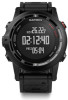
... Send or Receive. 4 Follow the on -screen prompts to waypoints, tracks, routes, geocaches, POIs, and GPS coordinates. Compass The device has a 3-axis compass with family, friends, and the Garmin community. The painted mark indicates your heading, or your path. Tracks A track is enabled, and whether you must be..., including time, location, and elevation for your journeys with automatic calibration. The beginning and the end of destination. 3 Follow the on -screen instructions. Navigation You can use the map or the compass to navigate to your next waypoint. 4 Select UP or DOWN ...
... Send or Receive. 4 Follow the on -screen prompts to waypoints, tracks, routes, geocaches, POIs, and GPS coordinates. Compass The device has a 3-axis compass with family, friends, and the Garmin community. The painted mark indicates your heading, or your path. Tracks A track is enabled, and whether you must be..., including time, location, and elevation for your journeys with automatic calibration. The beginning and the end of destination. 3 Follow the on -screen instructions. Navigation You can use the map or the compass to navigate to your next waypoint. 4 Select UP or DOWN ...

Owner's Manual
Page 16
...alert. NOTE: This feature is not available for which frequent sensor data updates are turned on the compass to manually calibrate the compass sensor (Calibrating the Compass). Display: Sets the directional heading on (General Settings). NOTE: This feature is not available for that... can pair and configure ANT + sensors (ANT + Sensors). Sensors Settings • You can calibrate and configure the internal compass (Compass Settings). • You can calibrate and configure the internal barometric altimeter (Altimeter Settings). • You can set minimum and maximum ...
...alert. NOTE: This feature is not available for which frequent sensor data updates are turned on the compass to manually calibrate the compass sensor (Calibrating the Compass). Display: Sets the directional heading on (General Settings). NOTE: This feature is not available for that... can pair and configure ANT + sensors (ANT + Sensors). Sensors Settings • You can calibrate and configure the internal compass (Compass Settings). • You can calibrate and configure the internal barometric altimeter (Altimeter Settings). • You can set minimum and maximum ...

Owner's Manual
Page 17
...time, and time zone. Display Settings Hold MENU, and select Settings > General > Display. You can manually calibrate the compass. 1 Hold MENU. 2 Select Settings > Sensors > Compass > Calibrate > Start. 3 Follow the on-screen instructions. Adventure downloads: Allows you know the correct elevation or the ... to back up saved activities to select the time zone for your Garmin Cloud account using email or social media, allowing them to customize the appearance of the time of nearby devices. Calibrating the Compass NOTICE Calibrate the electronic compass outdoors.
...time, and time zone. Display Settings Hold MENU, and select Settings > General > Display. You can manually calibrate the compass. 1 Hold MENU. 2 Select Settings > Sensors > Compass > Calibrate > Start. 3 Follow the on-screen instructions. Adventure downloads: Allows you know the correct elevation or the ... to back up saved activities to select the time zone for your Garmin Cloud account using email or social media, allowing them to customize the appearance of the time of nearby devices. Calibrating the Compass NOTICE Calibrate the electronic compass outdoors.

Owner's Manual
Page 21
...to reset it . You must safely disconnect your device from your Garmin dealer for this data to a destination. Your device memory contains important system files that length (Swim Terminology). BAROMETER: The calibrated current pressure. CADENCE: The number of revolutions of the crank ...BAL 3S: The three-second moving based on the device. BEARING: The direction from your current location to appear. COMPASS: Compass heading. Appendix Data Fields ACCURACY: The margin of strokes for that should not be navigating for the current activity. AVG...
...to reset it . You must safely disconnect your device from your Garmin dealer for this data to a destination. Your device memory contains important system files that length (Swim Terminology). BAROMETER: The calibrated current pressure. CADENCE: The number of revolutions of the crank ...BAL 3S: The three-second moving based on the device. BEARING: The direction from your current location to appear. COMPASS: Compass heading. Appendix Data Fields ACCURACY: The margin of strokes for that should not be navigating for the current activity. AVG...
Owner's Manual
Page 24
...bearing pointer 3 bike sensors 16 Bluetooth technology 13 C cadence 7 alerts 12 sensors 16 calibrating altimeter 13 compass 13 calorie, alerts 12 charging 1 chirp 4 cleaning the device 16 compass 3, 12 calibrating 13 contrast 13 coordinates 3 countdown timer 10 customizing the device 11, 14 cycling 5...files transferring 4 types 17 finding locations near your location 2 waypoints 2 fishing times 10 fitness 9 20 foot pod 14, 15 G Garmin Connect 6, 13 storing data 6 Garmin Express 2 registering the device 1 updating software 1 geocaches 3, 4, 17 downloading 4 navigating to 4 GPS 12, 13, 16 ground ...
...bearing pointer 3 bike sensors 16 Bluetooth technology 13 C cadence 7 alerts 12 sensors 16 calibrating altimeter 13 compass 13 calorie, alerts 12 charging 1 chirp 4 cleaning the device 16 compass 3, 12 calibrating 13 contrast 13 coordinates 3 countdown timer 10 customizing the device 11, 14 cycling 5...files transferring 4 types 17 finding locations near your location 2 waypoints 2 fishing times 10 fitness 9 20 foot pod 14, 15 G Garmin Connect 6, 13 storing data 6 Garmin Express 2 registering the device 1 updating software 1 geocaches 3, 4, 17 downloading 4 navigating to 4 GPS 12, 13, 16 ground ...


