
Owner's Manual
Page 4
... Page Options 20-21 Map Page Options 22 Pointer Page Options 23-25 Elevation Page 26-29 Mark Waypoint Page 30-31 Waypoint Page 32 Review Waypoint Page 33-34 Routes 35-37 Tracks 38-40 Calibration 41-43 Setup Page 43-44 Display Page 45 Units Page 45-48 Heading... Page 50-52 System Page 53-55 Appendicies Appendix A - Time Offset Chart 60 Appendix E - What is GPS 57-58 Appendix C - Wiring Diagram 62 Appendix G - Accessories 61 Appendix F -
... Page Options 20-21 Map Page Options 22 Pointer Page Options 23-25 Elevation Page 26-29 Mark Waypoint Page 30-31 Waypoint Page 32 Review Waypoint Page 33-34 Routes 35-37 Tracks 38-40 Calibration 41-43 Setup Page 43-44 Display Page 45 Units Page 45-48 Heading... Page 50-52 System Page 53-55 Appendicies Appendix A - Time Offset Chart 60 Appendix E - What is GPS 57-58 Appendix C - Wiring Diagram 62 Appendix G - Accessories 61 Appendix F -
Owner's Manual
Page 18
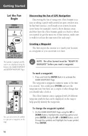
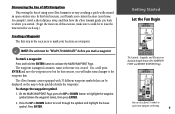
... waypoint now, but there are displayed along the bottom of the MARK WAYPOINT and REVIEW WAYPOINT Pages. On the MARK WAYPOINT Page, using your home for example), travel a short distance away, and then have the eTrex Summit guide you back to where you started (to get the most out of this ...Let the Fun Begin Discovering the Fun of GPS Navigation Discovering the fun of using the UP or DOWN Button, highlight the small flag symbol and press ENTER. Press and hold the ENTER Button to help quickly identify the waypoints. The eTrex Summit comes equipped with 29 different waypoint symbols ...
... waypoint now, but there are displayed along the bottom of the MARK WAYPOINT and REVIEW WAYPOINT Pages. On the MARK WAYPOINT Page, using your home for example), travel a short distance away, and then have the eTrex Summit guide you back to where you started (to get the most out of this ...Let the Fun Begin Discovering the Fun of GPS Navigation Discovering the fun of using the UP or DOWN Button, highlight the small flag symbol and press ENTER. Press and hold the ENTER Button to help quickly identify the waypoints. The eTrex Summit comes equipped with 29 different waypoint symbols ...
Owner's Manual
Page 20
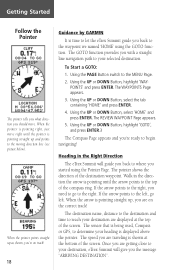
... you're on track! 18 Guidance by GARMIN It is pointing straight up and points to the moving direction line (see picture below). The REVIEW WAYPOINT Page appears. 5. Walk in the Right Direction The eTrex Summit will give you the message "ARRIVING DESTINATION...". Once you are getting close to your destination are traveling is pointing straight up , you are on the correct track! To Start a GOTO: 1. Heading in the direction the arrow is being used, Compass or GPS...
... you're on track! 18 Guidance by GARMIN It is pointing straight up and points to the moving direction line (see picture below). The REVIEW WAYPOINT Page appears. 5. Walk in the Right Direction The eTrex Summit will give you the message "ARRIVING DESTINATION...". Once you are getting close to your destination are traveling is pointing straight up , you are on the correct track! To Start a GOTO: 1. Heading in the direction the arrow is being used, Compass or GPS...
Owner's Manual
Page 34
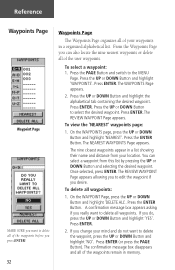
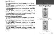
... The Waypoints Page organizes all waypoints. To view the 'NEAREST' waypoints page: 1. A confirmation message box appears asking if you desire. The REVIEW WAYPOINT Page appears. The REVIEW WAYPOINT Page appears allowing you to edit the waypoint if you really want to delete all of the waypoints remain in a organized alphabetical...
... The Waypoints Page organizes all waypoints. To view the 'NEAREST' waypoints page: 1. A confirmation message box appears asking if you desire. The REVIEW WAYPOINT Page appears. The REVIEW WAYPOINT Page appears allowing you to edit the waypoint if you really want to delete all of the waypoints remain in a organized alphabetical...
Owner's Manual
Page 35
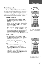
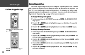
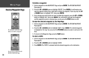
...the Map Page: 1. Press the ENTER Button. Press the ENTER Button. To view the selected waypoint on a map. To delete a waypoint: 1. On the REVIEW WAYPOINT Page, press the UP or DOWN Button and highlight 'GOTO'. You can use the UP/DOWN Buttons to zoom in memory (you to change... your mind and do , press the UP or DOWN Button, highlight 'YES' and press ENTER. 2. Review Waypoint Page The REVIEW WAYPOINT Page allows you change the waypoint symbol, name, and location (covered previously). A confirmation message box appears asking if you do ...
...the Map Page: 1. Press the ENTER Button. Press the ENTER Button. To view the selected waypoint on a map. To delete a waypoint: 1. On the REVIEW WAYPOINT Page, press the UP or DOWN Button and highlight 'GOTO'. You can use the UP/DOWN Buttons to zoom in memory (you to change... your mind and do , press the UP or DOWN Button, highlight 'YES' and press ENTER. 2. Review Waypoint Page The REVIEW WAYPOINT Page allows you change the waypoint symbol, name, and location (covered previously). A confirmation message box appears asking if you do ...
Owner's Manual
Page 36
... highlight to the next number in the field. Highlight 'GOTO' and press ENTER to save the waypoint. Reference Review Waypoint Page PROJECT WAYPOINT Page EDIT NUMBER Page Using the Project feature, the eTrex Summit can change the name, symbol and elevation on this page as a reference. You can create a waypoint at a speci...
... highlight to the next number in the field. Highlight 'GOTO' and press ENTER to save the waypoint. Reference Review Waypoint Page PROJECT WAYPOINT Page EDIT NUMBER Page Using the Project feature, the eTrex Summit can change the name, symbol and elevation on this page as a reference. You can create a waypoint at a speci...
Owner's Manual
Page 40
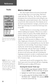
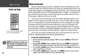
...before it is displayed at the top of the Tracks page. Reference Tracks You need to save a total of ten Track Logs in the eTrex Summit. The percentage of memory used for navigation later. Highlight the 'CLEAR' Button and press ENTER. 3. The 'Track Log' contains information ...saved Track Log on the map or to review the Track Logs elevation profile. 'TracBack' allows you to return along the way, including time, position and elevation. You will appear. 2. NOTE: For effective use the TracBack feature. The eTrex Summit draws an electronic breadcrumb trail on page 19...
...before it is displayed at the top of the Tracks page. Reference Tracks You need to save a total of ten Track Logs in the eTrex Summit. The percentage of memory used for navigation later. Highlight the 'CLEAR' Button and press ENTER. 3. The 'Track Log' contains information ...saved Track Log on the map or to review the Track Logs elevation profile. 'TracBack' allows you to return along the way, including time, position and elevation. You will appear. 2. NOTE: For effective use the TracBack feature. The eTrex Summit draws an electronic breadcrumb trail on page 19...
Owner's Manual (Software Version 3.00 and above)
Page 4
...Contents ii FCC Compliance iii Warnings and Cautions iv-v Consumer Limited Warranty vi Software License Agreement vii Maintenance viii GPS Cleaning viii Lens Cleaning viii Storage viii Water Immersion viii Features ix eTrex Summit Description x Buttons xi Battery Installation xii GETTING STARTED 1-12 Here We Go 1 Calibrating the Compass 2 ...20 Elevation Page 21-24 Options 21-23 Data Fields 24 Menu Page 25-39 Mark Waypoint Page 25-26 Waypoints Page 27 Review Waypoint Page 28-30 Hunt/Fish and Sun/Moon Pages 31 Project Waypoint Page 32 Routes Page 33-35 Track Log Page ...
...Contents ii FCC Compliance iii Warnings and Cautions iv-v Consumer Limited Warranty vi Software License Agreement vii Maintenance viii GPS Cleaning viii Lens Cleaning viii Storage viii Water Immersion viii Features ix eTrex Summit Description x Buttons xi Battery Installation xii GETTING STARTED 1-12 Here We Go 1 Calibrating the Compass 2 ...20 Elevation Page 21-24 Options 21-23 Data Fields 24 Menu Page 25-39 Mark Waypoint Page 25-26 Waypoints Page 27 Review Waypoint Page 28-30 Hunt/Fish and Sun/Moon Pages 31 Project Waypoint Page 32 Routes Page 33-35 Track Log Page ...
Owner's Manual (Software Version 3.00 and above)
Page 6
...charts and notices to facilitate the use . To reduce the risk of unsafe operation, carefully review and understand all available navigation sources, including the information from the eTrex Summit to actual use , carefully compare indications from other NAVAIDs, visual sightings, charts, etc.... PURPOSE REQUIRING PRECISE MEASUREMENT OF DIRECTION, DISTANCE, LOCATION OR TOPOGRAPHY. Introduction Warnings and Cautions CAUTION: Use the eTrex Summit at your own risk. For safety, always resolve any discrepancies before using the simulator mode prior to all aspects of ...
...charts and notices to facilitate the use . To reduce the risk of unsafe operation, carefully review and understand all available navigation sources, including the information from the eTrex Summit to actual use , carefully compare indications from other NAVAIDs, visual sightings, charts, etc.... PURPOSE REQUIRING PRECISE MEASUREMENT OF DIRECTION, DISTANCE, LOCATION OR TOPOGRAPHY. Introduction Warnings and Cautions CAUTION: Use the eTrex Summit at your own risk. For safety, always resolve any discrepancies before using the simulator mode prior to all aspects of ...
Owner's Manual (Software Version 3.00 and above)
Page 23
..." before you started. (To get the most out of the MARK WAYPOINT and REVIEW WAYPOINT Pages. Discovering the Fun of GPS Navigation Discovering the fun of using your location as taking a quick walk around an open outdoor area. The eTrex Summit comes equipped with 31 different waypoint symbols that can select from 31 symbols...
..." before you started. (To get the most out of the MARK WAYPOINT and REVIEW WAYPOINT Pages. Discovering the Fun of GPS Navigation Discovering the fun of using your location as taking a quick walk around an open outdoor area. The eTrex Summit comes equipped with 31 different waypoint symbols that can select from 31 symbols...

Owner's Manual (Software Version 3.00 and above)
Page 25
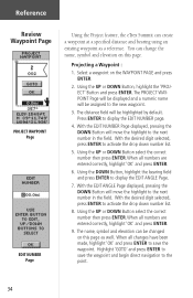
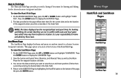
...then press ENTER. 4. Press the UP or DOWN button to highlight 'WAYPOINTS', then press ENTER. The REVIEW WAY- The pointer shows the direction of the screen. When the pointer is pointing right, just move .... pointing straight up and points to the moving direction line (see picture below). Guidance by Garmin It is pointing straight up, you are on track! 11 The GOTO function provides you ..., and time to determine your selected destination. The sensor (Compass or GPS) that is being used to reach your destination, eTrex Summit gives you 're ready to the MENU Page. 2. The speed you...
...then press ENTER. 4. Press the UP or DOWN button to highlight 'WAYPOINTS', then press ENTER. The REVIEW WAY- The pointer shows the direction of the screen. When the pointer is pointing right, just move .... pointing straight up and points to the moving direction line (see picture below). Guidance by Garmin It is pointing straight up, you are on track! 11 The GOTO function provides you ..., and time to determine your selected destination. The sensor (Compass or GPS) that is being used to reach your destination, eTrex Summit gives you 're ready to the MENU Page. 2. The speed you...

Owner's Manual (Software Version 3.00 and above)
Page 41
... to highlight 'WAYPOINTS'. Press ENTER. Press ENTER. Press ENTER. 2. The NEAREST WAYPOINTS Page appears, showing a list of your waypoints in memory. The REVIEW WAYPOINT Page appears. On the WAYPOINT Page, press the UP or DOWN button to the MENU Page. If you do not want to delete all... delete the waypoint, press the UP or DOWN button to edit, locate the nine nearest waypoints, or delete all of the user waypoints. The REVIEW WAYPOINT Page appears (see page 28 for more information). A confirmation message box appears asking if you can select a waypoint from your...
... to highlight 'WAYPOINTS'. Press ENTER. Press ENTER. Press ENTER. 2. The NEAREST WAYPOINTS Page appears, showing a list of your waypoints in memory. The REVIEW WAYPOINT Page appears. On the WAYPOINT Page, press the UP or DOWN button to the MENU Page. If you do not want to delete all... delete the waypoint, press the UP or DOWN button to edit, locate the nine nearest waypoints, or delete all of the user waypoints. The REVIEW WAYPOINT Page appears (see page 28 for more information). A confirmation message box appears asking if you can select a waypoint from your...
Owner's Manual (Software Version 3.00 and above)
Page 42
... change the waypoint symbol, name, elevation, and location. Press the UP or DOWN button to highlight the waypoint name, then press ENTER. The REVIEW WAYPOINT Page appears. 2. Press the UP or DOWN button to highlight the desired letter, then press ENTER. You can also delete the waypoint, ...button to save. Press ENTER. 3. Select a waypoint on the WAYPOINTS Page and press ENTER. You can access the Review Waypoint Page from the list and press ENTER. Menu Page Review Waypoint Page Select the desired symbol from the Waypoints Page (see page 27 for the waypoint, and project a new ...
... change the waypoint symbol, name, elevation, and location. Press the UP or DOWN button to highlight the waypoint name, then press ENTER. The REVIEW WAYPOINT Page appears. 2. Press the UP or DOWN button to highlight the desired letter, then press ENTER. You can also delete the waypoint, ...button to save. Press ENTER. 3. Select a waypoint on the WAYPOINTS Page and press ENTER. You can access the Review Waypoint Page from the list and press ENTER. Menu Page Review Waypoint Page Select the desired symbol from the Waypoints Page (see page 27 for the waypoint, and project a new ...
Owner's Manual (Software Version 3.00 and above)
Page 43
...LON' field, then press ENTER. The EDIT LOCATION Page appears. 3. Repeat until all numbers are changed . 5. The REVIEW WAYPOINT Page appears. The REVIEW WAYPOINT Page appears. 2. Press the UP or DOWN button to change the elevation for the waypoint. Repeat until location is now ...stored in memory. A selection window appears. 4. Menu Page Review Waypoint Page The 'ENTER CORRECT ELEVATION' Page allows you to highlight the desired letter or digit, then press ENTER. To change the ...
...LON' field, then press ENTER. The EDIT LOCATION Page appears. 3. Repeat until all numbers are changed . 5. The REVIEW WAYPOINT Page appears. The REVIEW WAYPOINT Page appears. 2. Press the UP or DOWN button to change the elevation for the waypoint. Repeat until location is now ...stored in memory. A selection window appears. 4. Menu Page Review Waypoint Page The 'ENTER CORRECT ELEVATION' Page allows you to highlight the desired letter or digit, then press ENTER. To change the ...
Owner's Manual (Software Version 3.00 and above)
Page 44
...press the PAGE button. Select a waypoint on the WAYPOINTS Page and press ENTER. Select a waypoint on the map. Press ENTER. The REVIEW WAYPOINT Page appears. 2. The 'GOTO' is displayed on the WAYPOINTS Page and press ENTER. A confirmation message box appears asking ...button to delete the waypoint. To return to highlight 'GOTO'. 3. Menu Page Review Waypoint Page The REVIEW WAYPOINT Page allows you to highlight 'DELETE'. The REVIEW WAYPOINT Page appears. 2. To start a GOTO from the REVIEW WAYPOINT Page. 30 To delete a waypoint: 1. Press the UP or DOWN ...
...press the PAGE button. Select a waypoint on the WAYPOINTS Page and press ENTER. Select a waypoint on the map. Press ENTER. The REVIEW WAYPOINT Page appears. 2. The 'GOTO' is displayed on the WAYPOINTS Page and press ENTER. A confirmation message box appears asking ...button to delete the waypoint. To return to highlight 'GOTO'. 3. Menu Page Review Waypoint Page The REVIEW WAYPOINT Page allows you to highlight 'DELETE'. The REVIEW WAYPOINT Page appears. 2. To start a GOTO from the REVIEW WAYPOINT Page. 30 To delete a waypoint: 1. Press the UP or DOWN ...
Owner's Manual (Software Version 3.00 and above)
Page 45
... the bottom of best times for hunting and fishing for the current date and at which may vary from location to location. On the REVIEW WAYPOINT Page, press the UP or DOWN button and highlight 'HUNT/ FISH'. On the HUNT/FISH Page, press the UP or DOWN button and highlight...
... the bottom of best times for hunting and fishing for the current date and at which may vary from location to location. On the REVIEW WAYPOINT Page, press the UP or DOWN button and highlight 'HUNT/ FISH'. On the HUNT/FISH Page, press the UP or DOWN button and highlight...
Owner's Manual (Software Version 3.00 and above)
Page 50
...ENTER. Menu Page Track Log Page You need to save a total of ten Track Logs in the eTrex Summit. You can save the track log first before you can be used by the current Track ...or DOWN button to use the Track Setup page to navigate. Press ENTER. The eTrex Summit draws an electronic "breadcrumb" trail on the map, review the Track Log's elevation profile, and use the 'TracBack feature (...at the top of the Tracks page. The Track Log starts recording as soon as you can also review the saved Track Log on the Map Page as the unit gets a location fix. The percentage of...
...ENTER. Menu Page Track Log Page You need to save a total of ten Track Logs in the eTrex Summit. You can save the track log first before you can be used by the current Track ...or DOWN button to use the Track Setup page to navigate. Press ENTER. The eTrex Summit draws an electronic "breadcrumb" trail on the map, review the Track Log's elevation profile, and use the 'TracBack feature (...at the top of the Tracks page. The Track Log starts recording as soon as you can also review the saved Track Log on the Map Page as the unit gets a location fix. The percentage of...
Quick Start Guide
Page 2
...switch to highlight 'TRACKS'. 3. A speed scale on saving the track log. Refer to a waypoint using the unit for navigation. or its subsidiaries Garmin International, Inc. 1200 E. 151st St., Olathe, KS 66062 USA Part Number 190-00396-01 Rev. The waypoint is displayed. 2. Follow the '...Elevation Profile you are now on course. The Review Waypoint page for information on the display indicates whether you will clear the Elevation Profile also. When the 'POINTER' is level, rotate the eTrex Summit slowly two turns in a direct line). Press the UP...
...switch to highlight 'TRACKS'. 3. A speed scale on saving the track log. Refer to a waypoint using the unit for navigation. or its subsidiaries Garmin International, Inc. 1200 E. 151st St., Olathe, KS 66062 USA Part Number 190-00396-01 Rev. The waypoint is displayed. 2. Follow the '...Elevation Profile you are now on course. The Review Waypoint page for information on the display indicates whether you will clear the Elevation Profile also. When the 'POINTER' is level, rotate the eTrex Summit slowly two turns in a direct line). Press the UP...