Pilot's Guide
Page 9
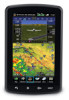
...aera 795/796 system and aviation databases. NOTE: This product, its packaging, and its components contain chemicals known to the State of California to change and may cause the flight displays to our web site at www.garmin.com/prop65. A Garmin aera 795/796 Pilot's Guide Moving the aircraft more than 100 yards away from GPS... hours. Warnings, Cautions & Notes NOTE: All visual depictions contained within this document, including screen images of the aera 795/796 panel and displays, are subject to cause cancer, birth defects, or reproductive harm. NOTE: Interference from the source...
...aera 795/796 system and aviation databases. NOTE: This product, its packaging, and its components contain chemicals known to the State of California to change and may cause the flight displays to our web site at www.garmin.com/prop65. A Garmin aera 795/796 Pilot's Guide Moving the aircraft more than 100 yards away from GPS... hours. Warnings, Cautions & Notes NOTE: All visual depictions contained within this document, including screen images of the aera 795/796 panel and displays, are subject to cause cancer, birth defects, or reproductive harm. NOTE: Interference from the source...
Pilot's Guide
Page 18
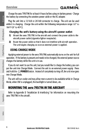
...Interfacing' for information on mounting the aera 795/796 in the aircraft. MOUNTING THE aera 795/796 IN THE AIRCRAFT Refer to an external power supply. Appendices Index 4 Garmin aera 795/796 Pilot's Guide 190-01194-00 ... the battery while the unit is applied. Charge the battery by connecting the aviation power cable or the AC adapter. Instead of completely turning off, the unit... Overview GPS Navigation Additional Features Hazard Avoidance Flight Planning Overview Charge the aera 795/796 for at least 4 hours before using the aircraft's power outlet: 1) Mount the aera 795/796 in ...
...Interfacing' for information on mounting the aera 795/796 in the aircraft. MOUNTING THE aera 795/796 IN THE AIRCRAFT Refer to an external power supply. Appendices Index 4 Garmin aera 795/796 Pilot's Guide 190-01194-00 ... the battery while the unit is applied. Charge the battery by connecting the aviation power cable or the AC adapter. Instead of completely turning off, the unit... Overview GPS Navigation Additional Features Hazard Avoidance Flight Planning Overview Charge the aera 795/796 for at least 4 hours before using the aircraft's power outlet: 1) Mount the aera 795/796 in ...

Pilot's Guide
Page 45
An aircraft icon is placed on GPS calculations. The basemap upon which these are shown in white. A Garmin aera 795/796 Pilot's Guide 31 The Navigation Map can be oriented three different ways: North Up (NORTH UP...Magenta) Aircraft Icon Flight Plan Legs (Navigation Map) Appendices Index 190-01194-00 Rev. Overview GPS Navigation Flight Planning Hazard Avoidance Additional Features SECTION 2 GPS NAVIGATION GPS Navigation 2.1 INTRODUCTION The Navigation Map displays aviation data (e.g., airports, VORs, airways, airspaces), geographic data (e.g., cities, lakes, highways, borders),...
An aircraft icon is placed on GPS calculations. The basemap upon which these are shown in white. A Garmin aera 795/796 Pilot's Guide 31 The Navigation Map can be oriented three different ways: North Up (NORTH UP...Magenta) Aircraft Icon Flight Plan Legs (Navigation Map) Appendices Index 190-01194-00 Rev. Overview GPS Navigation Flight Planning Hazard Avoidance Additional Features SECTION 2 GPS NAVIGATION GPS Navigation 2.1 INTRODUCTION The Navigation Map displays aviation data (e.g., airports, VORs, airways, airspaces), geographic data (e.g., cities, lakes, highways, borders),...
Pilot's Guide
Page 93
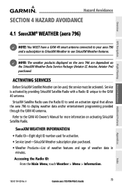
...GXM 40 antenna. A Garmin aera 795/796 Pilot's Guide 79 Overview GPS Navigation Flight Planning Hazard Avoidance Additional Features Hazard Avoidance SECTION 4 HAZARD AVOIDANCE 4.1 SiriusXM® WEATHER (aera 796) NOTE: You MUST have a GXM 40 smart antenna connected to your aera 796 and a subscription to... SiriusXM Weather to the GXM 40 antenna. ACTIVATING SERVICES Before SiriusXM Satellite Weather can be used for more information on the SiriusXM Weather Data Service Package (Aviator LT, Aviator, Aviator Pro) purchased. Service is...
...GXM 40 antenna. A Garmin aera 795/796 Pilot's Guide 79 Overview GPS Navigation Flight Planning Hazard Avoidance Additional Features Hazard Avoidance SECTION 4 HAZARD AVOIDANCE 4.1 SiriusXM® WEATHER (aera 796) NOTE: You MUST have a GXM 40 smart antenna connected to your aera 796 and a subscription to... SiriusXM Weather to the GXM 40 antenna. ACTIVATING SERVICES Before SiriusXM Satellite Weather can be used for more information on the SiriusXM Weather Data Service Package (Aviator LT, Aviator, Aviator Pro) purchased. Service is...

Pilot's Guide
Page 99
... and expected changes in weather conditions. Touching the Map Feature Button will display additional information. A Garmin aera 795/796 Pilot's Guide 85 METARs are updated hourly or as METAR data. If METAR data is shown ...next to the airport. TAFs may contain some of the same code as needed. Overview GPS...pressure. TAF (Terminal Area Forecast) is only displayed within the installed aviation database service area. METAR and TAF data can be viewed by selecting the METAR flag with the map...
... and expected changes in weather conditions. Touching the Map Feature Button will display additional information. A Garmin aera 795/796 Pilot's Guide 85 METARs are updated hourly or as METAR data. If METAR data is shown ...next to the airport. TAFs may contain some of the same code as needed. Overview GPS...pressure. TAF (Terminal Area Forecast) is only displayed within the installed aviation database service area. METAR and TAF data can be viewed by selecting the METAR flag with the map...
Pilot's Guide
Page 151
...Garmin Aviation Database Updates The Garmin aviation database updates can be downloaded directly to the PC's USB port. The update program is designed to operate on the splash screen during power-up. The following information is updated periodically and has no expiration date. A Garmin aera 795/796... Pilot's Guide 137 Appendices Index After the databases have been updated, check that provides location and facility information for thousands of the data. Worldwide Terrain Appendix C Overview GPS Navigation Flight Planning Hazard ...
...Garmin Aviation Database Updates The Garmin aviation database updates can be downloaded directly to the PC's USB port. The update program is designed to operate on the splash screen during power-up. The following information is updated periodically and has no expiration date. A Garmin aera 795/796... Pilot's Guide 137 Appendices Index After the databases have been updated, check that provides location and facility information for thousands of the data. Worldwide Terrain Appendix C Overview GPS Navigation Flight Planning Hazard ...
Pilot's Guide
Page 152
... is an obsolete Jeppesen aviation point in a saved route, the route is revised every 14 days. Charts are current. A Overview GPS Navigation Appendix C • Intersections-identifier, nearest VOR, radial and distance from Jeppesen® onto an SD card. Additional Features Hazard Avoidance Flight Planning Appendices Index 138 Garmin aera 795/796 Pilot's Guide 190-01194...
... is an obsolete Jeppesen aviation point in a saved route, the route is revised every 14 days. Charts are current. A Overview GPS Navigation Appendix C • Intersections-identifier, nearest VOR, radial and distance from Jeppesen® onto an SD card. Additional Features Hazard Avoidance Flight Planning Appendices Index 138 Garmin aera 795/796 Pilot's Guide 190-01194...
Pilot's Guide
Page 158
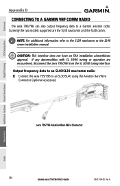
...nav/comm and the SL40 comm. Overview GPS Navigation Additional Features Hazard Avoidance Flight Planning Appendix D CONNECTING TO A GARMIN VHF COMM RADIO The aera 795/796 can also output frequency data to an SL30/SL40 using the Aviation Bare Wire Connector (optional accessory). Currently...SL30 nav/comm radio: 1) Connect the aera 795/796 to a Garmin aviation radio. NOTE: For additional information refer to the SL30 nav/comm or the SL40 comm installation manual. A aera 795/796 Aviation Bare Wire Connector Appendices Index 144 Garmin aera 795/796 Pilot's Guide 190-01194-00 Rev.
...nav/comm and the SL40 comm. Overview GPS Navigation Additional Features Hazard Avoidance Flight Planning Appendix D CONNECTING TO A GARMIN VHF COMM RADIO The aera 795/796 can also output frequency data to an SL30/SL40 using the Aviation Bare Wire Connector (optional accessory). Currently...SL30 nav/comm radio: 1) Connect the aera 795/796 to a Garmin aviation radio. NOTE: For additional information refer to the SL30 nav/comm or the SL40 comm installation manual. A aera 795/796 Aviation Bare Wire Connector Appendices Index 144 Garmin aera 795/796 Pilot's Guide 190-01194-00 Rev.

Pilot's Guide
Page 159
... list. Appendix D Overview GPS Navigation Flight Planning Hazard Avoidance Additional Features Connection Power Power Ground/Data Ground TX1 (Data Out) RX1 (Data In) TX2 (Data Out) RX2 (Data In) Audio Right Audio Common Audio Left Wire Color Red Black Blue Yellow Orange Purple White Green Brown aera 795/796 Aviation Bare Wire Connections 2) From...). Or: a) If the frequency has additional information (denoted with an *). b) Touch the 'Tune' Button. 190-01194-00 Rev. Touch the desired frequency from the list. A Garmin aera 795/796 Pilot's Guide 145 Appendices Index
... list. Appendix D Overview GPS Navigation Flight Planning Hazard Avoidance Additional Features Connection Power Power Ground/Data Ground TX1 (Data Out) RX1 (Data In) TX2 (Data Out) RX2 (Data In) Audio Right Audio Common Audio Left Wire Color Red Black Blue Yellow Orange Purple White Green Brown aera 795/796 Aviation Bare Wire Connections 2) From...). Or: a) If the frequency has additional information (denoted with an *). b) Touch the 'Tune' Button. 190-01194-00 Rev. Touch the desired frequency from the list. A Garmin aera 795/796 Pilot's Guide 145 Appendices Index
Pilot's Guide
Page 160
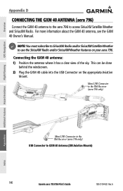
Overview GPS Navigation Appendix D CONNECTING THE GXM 40 ANTENNA (aera 796) Connect the GXM 40 antenna to the aera 796 to GXM 40 Antenna (XM Aviation Mounts) 146 Garmin aera 795/796 Pilot's Guide 190-01194-00 Rev. This can be done behind the windscreen. 2) Plug the GXM 40 cable into the USB Connector on your aera 796. Mini-USB Connector to...
Overview GPS Navigation Appendix D CONNECTING THE GXM 40 ANTENNA (aera 796) Connect the GXM 40 antenna to the aera 796 to GXM 40 Antenna (XM Aviation Mounts) 146 Garmin aera 795/796 Pilot's Guide 190-01194-00 Rev. This can be done behind the windscreen. 2) Plug the GXM 40 cable into the USB Connector on your aera 796. Mini-USB Connector to...

Pilot's Guide
Page 161
.... • Lost Connection-an error occurred or the connection to a Garmin aviation NAV/COM radio. A Garmin aera 795/796 Pilot's Guide 147 Appendices Index A vertical list is available from the Web site (www. garmin.com). 190-01194-00 Rev. For more information, see the GTX ..., GPBOD, GPRTE, and GPWPL. Garmin's proprietary communication protocol is displayed. 4) Touch 'TIS In' or 'TIS In/NMEA & VHF Out'. Configuring TIS input: 1) Connect the aera 795/796 to TIS In or TIS In/NMEA & VHF Out. Appendix D Overview GPS Navigation Flight Planning Hazard Avoidance Additional ...
.... • Lost Connection-an error occurred or the connection to a Garmin aviation NAV/COM radio. A Garmin aera 795/796 Pilot's Guide 147 Appendices Index A vertical list is available from the Web site (www. garmin.com). 190-01194-00 Rev. For more information, see the GTX ..., GPBOD, GPRTE, and GPWPL. Garmin's proprietary communication protocol is displayed. 4) Touch 'TIS In' or 'TIS In/NMEA & VHF Out'. Configuring TIS input: 1) Connect the aera 795/796 to TIS In or TIS In/NMEA & VHF Out. Appendix D Overview GPS Navigation Flight Planning Hazard Avoidance Additional ...
Pilot's Guide
Page 162
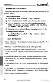
..., and navigation data. • Aviation In-the proprietary format used when connecting the unit to a Garmin panelmounted GPS receiver. A Overview GPS Navigation Additional Features Hazard Avoidance Flight Planning Appendix D GENERAL INTERFACE SETUP The Interface Setup controls the input/output format used for connection to external devices. Appendices Index 148 Garmin aera 795/796 Pilot's Guide 190-01194...
..., and navigation data. • Aviation In-the proprietary format used when connecting the unit to a Garmin panelmounted GPS receiver. A Overview GPS Navigation Additional Features Hazard Avoidance Flight Planning Appendix D GENERAL INTERFACE SETUP The Interface Setup controls the input/output format used for connection to external devices. Appendices Index 148 Garmin aera 795/796 Pilot's Guide 190-01194...
Pilot's Guide
Page 169
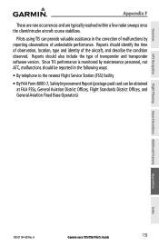
...GPS Navigation Appendix F These are rare occurrences and are typically resolved within a few radar sweeps once the client/intruder aircraft course stabilizes. Reports should identify the time of observation, location, type and identity of transponder and transponder software version. Since TIS performance is monitored by reporting observations of undesirable performance. A Garmin aera 795/796... Pilot's Guide 155 Reports should be obtained at FAA FSSs, General Aviation District Offices, Flight Standards District Offices, and General Aviation Fixed Base...
...GPS Navigation Appendix F These are rare occurrences and are typically resolved within a few radar sweeps once the client/intruder aircraft course stabilizes. Reports should identify the time of observation, location, type and identity of transponder and transponder software version. Since TIS performance is monitored by reporting observations of undesirable performance. A Garmin aera 795/796... Pilot's Guide 155 Reports should be obtained at FAA FSSs, General Aviation District Offices, Flight Standards District Offices, and General Aviation Fixed Base...
Pilot's Guide
Page 196
...Arrival ETE Estimated Time Enroute ºF degrees Fahrenheit FAA Federal Aviation Administration FAF Final Approach Fix FCC Federal Communication Commission fpm feet per hour Global Positioning System Appendices Index 182 Garmin aera 795/796 Pilot's Guide 190-01194-00 Rev. gallons per minute FSS... Flight Service Station ft foot/feet gal Glide Ratio, G/R gph GPS gallon(s) The estimated distance an aircraft will move forward...
...Arrival ETE Estimated Time Enroute ºF degrees Fahrenheit FAA Federal Aviation Administration FAF Final Approach Fix FCC Federal Communication Commission fpm feet per hour Global Positioning System Appendices Index 182 Garmin aera 795/796 Pilot's Guide 190-01194-00 Rev. gallons per minute FSS... Flight Service Station ft foot/feet gal Glide Ratio, G/R gph GPS gallon(s) The estimated distance an aircraft will move forward...

Pilot's Guide
Page 197
... Approach Fix Indicated Air Temperature International Civil Aviation Organization Instrument Flight Rules Instrument Landing System Instrument Meteorological Conditions inch Information provided by 1000 feet for all areas of mercury kilogram kilohertz kilometer Garmin aera 795/796 Pilot's Guide 183 Index Appendices Flight Planning Hazard Avoidance Additional Features GPS Navigation Overview A Appendix J Grid Minimum Off-Route...
... Approach Fix Indicated Air Temperature International Civil Aviation Organization Instrument Flight Rules Instrument Landing System Instrument Meteorological Conditions inch Information provided by 1000 feet for all areas of mercury kilogram kilohertz kilometer Garmin aera 795/796 Pilot's Guide 183 Index Appendices Flight Planning Hazard Avoidance Additional Features GPS Navigation Overview A Appendix J Grid Minimum Off-Route...

Pilot's Guide
Page 198
LOC localizer LON longitude m MAP METAR MHz Minimum Safe Altitude MOA MSA MSL meter Missed Approach Point Meteorological Aviation Routine megahertz Uses Grid MORAs to determine a safe altitude within ten miles of a flight plan between two waypoints. Military ...(s) OAT Outside Air Temperature OBS Omni Bearing Selector psi pounds per square inch QTY quantity Appendices Index 184 Garmin aera 795/796 Pilot's Guide 190-01194-00 Rev. Overview GPS Navigation Additional Features Hazard Avoidance Flight Planning Appendix J kt knot LAT latitude lb pound Leg The portion of...
LOC localizer LON longitude m MAP METAR MHz Minimum Safe Altitude MOA MSA MSL meter Missed Approach Point Meteorological Aviation Routine megahertz Uses Grid MORAs to determine a safe altitude within ten miles of a flight plan between two waypoints. Military ...(s) OAT Outside Air Temperature OBS Omni Bearing Selector psi pounds per square inch QTY quantity Appendices Index 184 Garmin aera 795/796 Pilot's Guide 190-01194-00 Rev. Overview GPS Navigation Additional Features Hazard Avoidance Flight Planning Appendix J kt knot LAT latitude lb pound Leg The portion of...
Quick Reference Guide
Page 8
...data is provided by the FAA and may not be updated outside of the aera 795/796 panel and displays, are subject to change and may not reflect the most current aera 795/796 system and aviation databases. Confirm data currency through alternate sources and contact your local FSS for ... eyewear may differ slightly from GPS repeaters operating inside nearby hangars can cause an intermittent loss of equipment may cause the flight displays to our web site at www.garmin.com/prop65. NOTE: Use of the interference should alleviate the condition. Garmin aera 795/796 Quick Reference Guide 190-01194-...
...data is provided by the FAA and may not be updated outside of the aera 795/796 panel and displays, are subject to change and may not reflect the most current aera 795/796 system and aviation databases. Confirm data currency through alternate sources and contact your local FSS for ... eyewear may differ slightly from GPS repeaters operating inside nearby hangars can cause an intermittent loss of equipment may cause the flight displays to our web site at www.garmin.com/prop65. NOTE: Use of the interference should alleviate the condition. Garmin aera 795/796 Quick Reference Guide 190-01194-...


