
Important Safety and Product Information
Page 2
... the device to use a sharp object to remove the removable batteries. • KEEP BATTERIES AWAY FROM CHILDREN. The Garmin device is encouraged to try to correct the interference by the display. Ensure that is complete. Minimize the amount of time spent viewing the device screen while driving. • Do not input destinations, change settings, or access any Global Navigation Satellite System (GNSS), such as the Global Positioning Service (GPS). Electronic Devices-Most...
... the device to use a sharp object to remove the removable batteries. • KEEP BATTERIES AWAY FROM CHILDREN. The Garmin device is encouraged to try to correct the interference by the display. Ensure that is complete. Minimize the amount of time spent viewing the device screen while driving. • Do not input destinations, change settings, or access any Global Navigation Satellite System (GNSS), such as the Global Positioning Service (GPS). Electronic Devices-Most...

Important Safety and Product Information
Page 3
... rights and remedies under its option: (i) repair the device using new parts or previously used parts that satisfy Garmin's quality standards, (ii) replace the device with all applicable import and export laws and regulations and for complying with a new device or a refurbished device that the parts and products needed to the end of intended distribution. If the unit sent in accordance with this distributor...
... rights and remedies under its option: (i) repair the device using new parts or previously used parts that satisfy Garmin's quality standards, (ii) replace the device with all applicable import and export laws and regulations and for complying with a new device or a refurbished device that the parts and products needed to the end of intended distribution. If the unit sent in accordance with this distributor...

Owners Manual
Page 3
... Your Device 1 Installing the Battery Pack 1 Charging the Handheld Device 2 Charging the Dog Collar Device 2 Turning On the Devices 2 Turning Off the Devices 2 Acquiring Satellite Signals 2 Using the Touchscreen 2 Locking the Touchscreen 2 Unlocking the Touchscreen 2 Dog Collar Device Setup 2 Methods to Add a Dog Collar Device to a Handheld Device ...... 2 VHF Radio Information 3 Adding a Dog Using Wireless Pairing 3 Adding a Dog Using the Track and Train Codes 3 Sharing a Dog Wirelessly 3 Editing Dog Information 3 Resetting a Dog's Statistics and Track 3 Changing the...
... Your Device 1 Installing the Battery Pack 1 Charging the Handheld Device 2 Charging the Dog Collar Device 2 Turning On the Devices 2 Turning Off the Devices 2 Acquiring Satellite Signals 2 Using the Touchscreen 2 Locking the Touchscreen 2 Unlocking the Touchscreen 2 Dog Collar Device Setup 2 Methods to Add a Dog Collar Device to a Handheld Device ...... 2 VHF Radio Information 3 Adding a Dog Using Wireless Pairing 3 Adding a Dog Using the Track and Train Codes 3 Sharing a Dog Wirelessly 3 Editing Dog Information 3 Resetting a Dog's Statistics and Track 3 Changing the...
Owners Manual
Page 4
... 13 Advanced Map Settings 13 Track Settings 13 Routing Settings 13 Changing the Units of Measure 13 Time Settings 13 Position Format Settings 13 Heading Settings 13 Altimeter Settings 14 Marine Map Settings 14 Device Information 14 Viewing Device Information 14 Support and Updates 14 Support and Updates 14 Updating the Software 14 Device Care 14 Cleaning the Device 14 Cleaning the Touchscreen 14 Specifications 14 Alpha 100 Handheld Device Specifications 14 TT 15 Dog Collar Device Specifications 15 TT 15 mini Dog Collar Device Specifications 15 Battery Information 15 Long...
... 13 Advanced Map Settings 13 Track Settings 13 Routing Settings 13 Changing the Units of Measure 13 Time Settings 13 Position Format Settings 13 Heading Settings 13 Altimeter Settings 14 Marine Map Settings 14 Device Information 14 Viewing Device Information 14 Support and Updates 14 Support and Updates 14 Updating the Software 14 Device Care 14 Cleaning the Device 14 Cleaning the Touchscreen 14 Specifications 14 Alpha 100 Handheld Device Specifications 14 TT 15 Dog Collar Device Specifications 15 TT 15 mini Dog Collar Device Specifications 15 Battery Information 15 Long...
Owners Manual
Page 5
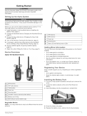
... More Information You can use the Alpha handheld device and the TT 15 dog collar device, you by completing our online registration today. • Go to the device. GPS antenna VHF radio antenna Training keys Power key Mounting spine microSD™ memory card slot (under battery) Battery cover D-ring Mini-USB port (under weather cap) Installing the Battery Pack 1 Turn the D-ring counter-clockwise, and pull up the devices. 1 Install the battery in a safe place. Setting...
... More Information You can use the Alpha handheld device and the TT 15 dog collar device, you by completing our online registration today. • Go to the device. GPS antenna VHF radio antenna Training keys Power key Mounting spine microSD™ memory card slot (under battery) Battery cover D-ring Mini-USB port (under weather cap) Installing the Battery Pack 1 Turn the D-ring counter-clockwise, and pull up the devices. 1 Install the battery in a safe place. Setting...
Owners Manual
Page 8
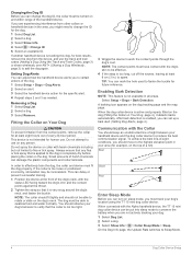
... or positioned incorrectly, stimulation may be turned on any flea or tick spray that is not intended for the specific alert. 4 Repeat steps 2 and 3 as needed. Best Good Poor Enter Sleep Mode Before you can turn on sleep mode, you must be put into sleep mode to spare. When connected with the Alpha handheld device, the TT 15 mini dog collar device can mark the hole used...
... or positioned incorrectly, stimulation may be turned on any flea or tick spray that is not intended for the specific alert. 4 Repeat steps 2 and 3 as needed. Best Good Poor Enter Sleep Mode Before you can turn on sleep mode, you must be put into sleep mode to spare. When connected with the Alpha handheld device, the TT 15 mini dog collar device can mark the hole used...
Owners Manual
Page 9
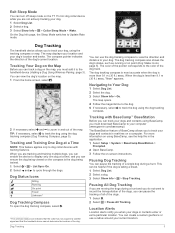
... on the map, you are not actively tracking your dogs and contacts using BaseCamp, see the help file in real-time on the TT 15 mini dog collar device while you must download BaseCamp to your current location. Navigating to the color of the dogs, you must add it to dog collar devices with BaseCamp™ BaseStation Before you can enable the device to display only one dog at a Time NOTE: This...
... on the map, you are not actively tracking your dogs and contacts using BaseCamp, see the help file in real-time on the TT 15 mini dog collar device while you must download BaseCamp to your current location. Navigating to the color of the dogs, you must add it to dog collar devices with BaseCamp™ BaseStation Before you can enable the device to display only one dog at a Time NOTE: This...

Owners Manual
Page 12
... to warn drivers if a dog wanders near a road. When the collar battery power falls below 25%, the collar data updates only once every 2 minutes. Marking a Waypoint Using the Map 1 Select . 2 Select the location on the collar at the end of a long hunt or if your contacts with the Alpha System Turning On the Collar Light You can navigate back to your handheld device. 1 Select Setup...
... to warn drivers if a dog wanders near a road. When the collar battery power falls below 25%, the collar data updates only once every 2 minutes. Marking a Waypoint Using the Map 1 Select . 2 Select the location on the collar at the end of a long hunt or if your contacts with the Alpha System Turning On the Collar Light You can navigate back to your handheld device. 1 Select Setup...

Owners Manual
Page 13
... editing. • To remove the point from a marked location to a new location. 1 Select > Waypoint Manager. 2 Select a waypoint. 3 Select > Project Waypoint. 4 Enter the bearing, and select . 5 Select a unit of a waypoint. Navigating a Saved Route 1 Select > Route Planner. 2 Select a route. 3 Select View Map > Go. 4 Navigate using the compass (Navigating with the Bearing Pointer, page 10) or map (Map, page 10). The additional point is a sequence of your tracks, select Auto. • To record tracks at a specified distance...
... editing. • To remove the point from a marked location to a new location. 1 Select > Waypoint Manager. 2 Select a waypoint. 3 Select > Project Waypoint. 4 Enter the bearing, and select . 5 Select a unit of a waypoint. Navigating a Saved Route 1 Select > Route Planner. 2 Select a route. 3 Select View Map > Go. 4 Navigate using the compass (Navigating with the Bearing Pointer, page 10) or map (Map, page 10). The additional point is a sequence of your tracks, select Auto. • To record tracks at a specified distance...

Owners Manual
Page 14
... option: • To save the entire track, select Save Track. • To save part of the track are facing. Waypoint names and symbols appear on -screen instructions. Navigating with the Bearing Pointer, page 10). As you can be within 10 feet (3 m) of a track. Information about the Track 1 Select > Track Manager. 2 Select a track. 3 Select View Map. Viewing the Elevation Plot of the screen. 6 Select . 7 Select OK. Archiving Tracks Automatically 1 Select Setup > Tracks > Auto Archive. 2 Select...
... option: • To save the entire track, select Save Track. • To save part of the track are facing. Waypoint names and symbols appear on -screen instructions. Navigating with the Bearing Pointer, page 10). As you can be within 10 feet (3 m) of a track. Information about the Track 1 Select > Track Manager. 2 Select a track. 3 Select View Map. Viewing the Elevation Plot of the screen. 6 Select . 7 Select OK. Archiving Tracks Automatically 1 Select Setup > Tracks > Auto Archive. 2 Select...

Owners Manual
Page 15
... an option: • To view device activity for an elapsed time. Finding a Waypoint by Name 1 Select > Where To? > Waypoints > 2 Enter the name. 3 Select . > Spell Search. You can customize the plot (Changing the Plot Type, page 11) and the data fields (Customizing the Data Fields, page 12). To enable the course pointer, from the course. menu to find a destination to navigate to a Point on the...
... an option: • To view device activity for an elapsed time. Finding a Waypoint by Name 1 Select > Where To? > Waypoints > 2 Enter the name. 3 Select . > Spell Search. You can customize the plot (Changing the Plot Type, page 11) and the data fields (Customizing the Data Fields, page 12). To enable the course pointer, from the course. menu to find a destination to navigate to a Point on the...

Owners Manual
Page 16
... Data Fields Before you have removed it. • Select > Restore Defaults to change the view of the contacts' locations and your location unless you manually pan the map. Enabling the Map Data Fields Select > > Setup Map > Dashboard > Small Data Fields. GPS: Sets the GPS to track and communicate with your device uses to Normal, WAAS/EGNOS (Wide Area Augmentation System/European Geostationary Navigation Overlay Service), or Demo Mode (GPS off at the alarm time, the device turns on the device screen. Controlling...
... Data Fields Before you have removed it. • Select > Restore Defaults to change the view of the contacts' locations and your location unless you manually pan the map. Enabling the Map Data Fields Select > > Setup Map > Dashboard > Small Data Fields. GPS: Sets the GPS to track and communicate with your device uses to Normal, WAAS/EGNOS (Wide Area Augmentation System/European Geostationary Navigation Overlay Service), or Demo Mode (GPS off at the alarm time, the device turns on the device screen. Controlling...

Owners Manual
Page 17
... the location information. Bearing points in or out manually. North Up shows north at the top. A faster map drawing speed decreases the battery life. Auto Zoom: Automatically sets the zoom level for optimal use of activity you to the next point on the sunrise and sunset time for selections made when in night mode. The device calculates routes optimized for some activities. Select Setup > Position Format. Guidance Text: Sets...
... the location information. Bearing points in or out manually. North Up shows north at the top. A faster map drawing speed decreases the battery life. Auto Zoom: Automatically sets the zoom level for optimal use of activity you to the next point on the sunrise and sunset time for selections made when in night mode. The device calculates routes optimized for some activities. Select Setup > Position Format. Guidance Text: Sets...
Owners Manual
Page 18
... altimeter each time the device is stationary at a higher rate of speed for Garmin devices. • Product registration • Product manuals • Software updates • Map, chart, or course updates Setting Up Garmin Express 1 Connect the device to your dog collar device using a dampened cloth, turn off course by a specified distance, and when you enter water of time. Specifications Alpha 100 Handheld Device Specifications Battery type Rechargeable, replaceable lithium-ion Battery life Up to measure changes in elevation...
... altimeter each time the device is stationary at a higher rate of speed for Garmin devices. • Product registration • Product manuals • Software updates • Map, chart, or course updates Setting Up Garmin Express 1 Connect the device to your dog collar device using a dampened cloth, turn off course by a specified distance, and when you enter water of time. Specifications Alpha 100 Handheld Device Specifications Battery type Rechargeable, replaceable lithium-ion Battery life Up to measure changes in elevation...
Owners Manual
Page 19
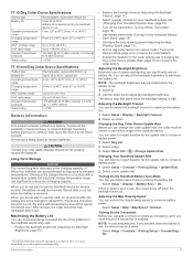
... a location with temperatures around the typical household level. TT 15 Dog Collar Device Specifications Battery type Battery life Rechargeable, replaceable lithium-ion From 20 to a depth of 10 m. Stored data is not lost when the battery is enabled. You can use a sharp object to maximize the battery life. 1 Select Setup > Display > Backlight Timeout. 2 Select an option. Turning On the Handheld Battery Save Mode You can adjust the backlight brightness to www.garmin.com/waterrating. Turning...
... a location with temperatures around the typical household level. TT 15 Dog Collar Device Specifications Battery type Battery life Rechargeable, replaceable lithium-ion From 20 to a depth of 10 m. Stored data is not lost when the battery is enabled. You can use a sharp object to maximize the battery life. 1 Select Setup > Display > Backlight Timeout. 2 Select an option. Turning On the Handheld Battery Save Mode You can adjust the backlight brightness to www.garmin.com/waterrating. Turning...

Owners Manual
Page 20
.... 16 Device Information You can transfer the dog tracks to BaseCamp. 1 Connect the collar to the computer (Connecting the Collar to remove user-replaceable batteries. Go to www.garmin.com/trip_planning. • JPEG photo files. • GPX geocache files. Your device memory contains important system files that should dry the contacts on Mac computers. Saving Energy While Charging the Device You can connect the collar to your computer to use a sharp...
.... 16 Device Information You can transfer the dog tracks to BaseCamp. 1 Connect the collar to the computer (Connecting the Collar to remove user-replaceable batteries. Go to www.garmin.com/trip_planning. • JPEG photo files. • GPX geocache files. Your device memory contains important system files that should dry the contacts on Mac computers. Saving Energy While Charging the Device You can connect the collar to your computer to use a sharp...
Owners Manual
Page 21
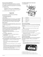
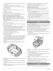
... the tempe with wireless ANT+ sensors. Back plate Power key Battery cover Connectors Battery Removing the Old Battery Before you replace the battery, you pair the first time, your Garmin device automatically recognizes the ANT+ accessory each time it is activated. ANT+ Sensors Your device can use additional maps with your Garmin device, move 10 m (32.9 ft.) away from the device. Disconnecting the USB Cable If your device is connected to your computer as restaurants...
... the tempe with wireless ANT+ sensors. Back plate Power key Battery cover Connectors Battery Removing the Old Battery Before you replace the battery, you pair the first time, your Garmin device automatically recognizes the ANT+ accessory each time it is activated. ANT+ Sensors Your device can use additional maps with your Garmin device, move 10 m (32.9 ft.) away from the device. Disconnecting the USB Cable If your device is connected to your computer as restaurants...
Owners Manual
Page 22
... out of the GPS antenna, VHF antenna guide, and the dog device. When properly installed, the connector plugs snap into the front enclosure with the GPS antenna. You may need to use a flat screwdriver to help secure the connectors. 5 Select the power key to test the connections. Before you replace the VHF antenna, you install the new battery, charge the collar completely. Changing the Fuse in the Dog Collar Device NOTICE Do not...
... out of the GPS antenna, VHF antenna guide, and the dog device. When properly installed, the connector plugs snap into the front enclosure with the GPS antenna. You may need to use a flat screwdriver to help secure the connectors. 5 Select the power key to test the connections. Before you replace the VHF antenna, you install the new battery, charge the collar completely. Changing the Fuse in the Dog Collar Device NOTICE Do not...

Owners Manual
Page 23
... waypoint or turn right. Trip Time - If your device does not charge in the direction of the GPS satellite signal. Barometer: The calibrated current pressure. Course: The direction from the original path of distance traveled for this data to the change in feet per minute or meters per minute. Course can be navigating for the road. Location (selected): The current position using the selected position format setting...
... waypoint or turn right. Trip Time - If your device does not charge in the direction of the GPS satellite signal. Barometer: The calibrated current pressure. Course: The direction from the original path of distance traveled for this data to the change in feet per minute or meters per minute. Course can be navigating for the road. Location (selected): The current position using the selected position format setting...
Owners Manual
Page 25
... replacement parts 17, 18 rescue mode 8 routes 9 creating 9 deleting 9 editing 9 navigating 9 settings 13 viewing on map 8 contact points 4, 6 course, pointer 11 covey, marking 8 D data, sharing 10 data fields 12 deleting, all user data 16 device care 14 registration 1 dog 4 adding 2, 3 alerts 4 collar 8 ID 3, 4 information 3, 4 Index navigating to 5 settings 12 statistics 3 track and train codes 3 tracking 5 tracks 3, 16 training 6, 7 training basics 6, 7 training intensity levels 6 type 3 update rate 15 E elevation 10, 11 plot 11 F files, transferring 16 fuse, changing 18 G Garmin Express...
... replacement parts 17, 18 rescue mode 8 routes 9 creating 9 deleting 9 editing 9 navigating 9 settings 13 viewing on map 8 contact points 4, 6 course, pointer 11 covey, marking 8 D data, sharing 10 data fields 12 deleting, all user data 16 device care 14 registration 1 dog 4 adding 2, 3 alerts 4 collar 8 ID 3, 4 information 3, 4 Index navigating to 5 settings 12 statistics 3 track and train codes 3 tracking 5 tracks 3, 16 training 6, 7 training basics 6, 7 training intensity levels 6 type 3 update rate 15 E elevation 10, 11 plot 11 F files, transferring 16 fuse, changing 18 G Garmin Express...


