Owner's Manual
Page 5
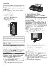
...122°F (0 to remove optional mount accessories. Use NiMH or lithium batteries for the Oregon 650 models when using the optional NiMH battery pack (650 and 650t only) or two ... Battery Pack The device operates using the camera feature. 1 Turn the D-ring counter-clockwise, and pull up the device and get to know the basic features. 1 Install the batteries (page 1). 2 ... and the surrounding area before charging or connecting to charge a battery that was not provided by Garmin can charge the battery using your device, you can rupture at high temperatures. Do not attempt to...
...122°F (0 to remove optional mount accessories. Use NiMH or lithium batteries for the Oregon 650 models when using the optional NiMH battery pack (650 and 650t only) or two ... Battery Pack The device operates using the camera feature. 1 Turn the D-ring counter-clockwise, and pull up the device and get to know the basic features. 1 Install the batteries (page 1). 2 ... and the surrounding area before charging or connecting to charge a battery that was not provided by Garmin can charge the battery using your device, you can rupture at high temperatures. Do not attempt to...

Owner's Manual
Page 6
... Select a waypoint. 3 Select > Project Waypoint. 4 Enter the bearing, and select . 5 Select a unit of a Waypoint Location You can use the GPS navigation features, such as recording a track, you must create a waypoint. 1 Select Waypoint Manager. 2 Select a waypoint. 3 Select an item to view the list of the screen... point on the map. • Select Compass to view the compass and customizable data fields. • Select Trip Computer to www.garmin.com / aboutGPS. 1 Hold . 2 Wait while the device locates satellites. When turns green, your current location as the name. 4...
... Select a waypoint. 3 Select > Project Waypoint. 4 Enter the bearing, and select . 5 Select a unit of a Waypoint Location You can use the GPS navigation features, such as recording a track, you must create a waypoint. 1 Select Waypoint Manager. 2 Select a waypoint. 3 Select an item to view the list of the screen... point on the map. • Select Compass to view the compass and customizable data fields. • Select Trip Computer to www.garmin.com / aboutGPS. 1 Hold . 2 Wait while the device locates satellites. When turns green, your current location as the name. 4...

Owner's Manual
Page 16
.... 1 Select Setup > Fitness > Auto Lap. 2 Enter a value, and select . This feature is using. Marine Chart Mode: Sets the type of paper charts. Nautical displays various map features in different colors so the marine POIs are off course by Distance You can reset all waypoints,...exceed a specified drift distance while anchored, when you to automatically mark the lap at www.garmin.com. Fitness Settings Select Setup > Fitness. FIT Activity: Sets the fitness activity to Garmin Connect. Marking Laps by a specified distance, and when you transfer it to running activity ...
.... 1 Select Setup > Fitness > Auto Lap. 2 Enter a value, and select . This feature is using. Marine Chart Mode: Sets the type of paper charts. Nautical displays various map features in different colors so the marine POIs are off course by Distance You can reset all waypoints,...exceed a specified drift distance while anchored, when you to automatically mark the lap at www.garmin.com. Fitness Settings Select Setup > Fitness. FIT Activity: Sets the fitness activity to Garmin Connect. Marking Laps by a specified distance, and when you transfer it to running activity ...
Owner's Manual
Page 17
... dampened cloth, turn off when the backlight times out. File Types The handheld device supports these file types: • Files from the Garmin POI Loader. Go to 45°C) range Radio frequency/ protocol 2. 4 GHz ANT + wireless communications protocol Bluetooth enabled device Data Management ...for the device may result. The display turns off the device display and all other features while charging. 1 Connect your local waste disposal department to 5 seconds. Stored data is waterproof to www.garmin.com/ trip _ planning. • GPX track files. • GPX geocache files....
... dampened cloth, turn off when the backlight times out. File Types The handheld device supports these file types: • Files from the Garmin POI Loader. Go to 45°C) range Radio frequency/ protocol 2. 4 GHz ANT + wireless communications protocol Bluetooth enabled device Data Management ...for the device may result. The display turns off the device display and all other features while charging. 1 Connect your local waste disposal department to 5 seconds. Stored data is waterproof to www.garmin.com/ trip _ planning. • GPX track files. • GPX geocache files....
Quick Start Manual
Page 2
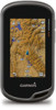
...5 Select to view the status page (page 4). 6 Mark a waypoint (page 3). 7 Navigate to know the basic features. 1 Install the batteries (page 2). 2 Turn on your device, you should complete these tasks to set up the ... Mini-USB port (under weather cap) Å Battery Information WARNING The temperature rating for the Oregon 650 models when using the optional NiMH battery pack (650 and 650t only) or two AA ...Alkaline batteries can use the device to charge a battery that was not provided by Garmin can charge the battery using your local waste disposal department to charge a battery ...
...5 Select to view the status page (page 4). 6 Mark a waypoint (page 3). 7 Navigate to know the basic features. 1 Install the batteries (page 2). 2 Turn on your device, you should complete these tasks to set up the ... Mini-USB port (under weather cap) Å Battery Information WARNING The temperature rating for the Oregon 650 models when using the optional NiMH battery pack (650 and 650t only) or two AA ...Alkaline batteries can use the device to charge a battery that was not provided by Garmin can charge the battery using your local waste disposal department to charge a battery ...

Quick Start Manual
Page 3
... an option: • Select Map to view your current speed, distance, and other helpful statistics. menu to find a destination to navigate to www.garmin.com / aboutGPS. 1 Hold . 2 Wait while the device locates satellites. categories are viewing. Tracks A track is not recorded. You can customize ... Track Log You can select to select an item. • Drag or swipe your current location as recording a track, you can use the GPS navigation features, such as a waypoint. 1 Select the user key. 3 Replace the battery cover, and turn the D-ring clockwise. 4 Hold . 5 Select Setup >...
... an option: • Select Map to view your current speed, distance, and other helpful statistics. menu to find a destination to navigate to www.garmin.com / aboutGPS. 1 Hold . 2 Wait while the device locates satellites. categories are viewing. Tracks A track is not recorded. You can customize ... Track Log You can select to select an item. • Drag or swipe your current location as recording a track, you can use the GPS navigation features, such as a waypoint. 1 Select the user key. 3 Replace the battery cover, and turn the D-ring clockwise. 4 Hold . 5 Select Setup >...
