Technical Reference for Garmin NMEA 2000 Products
Page 37
... command, enter the percentage of the trim tab. 11. To access the NMEA 2000 configuration menu on your display device, consult the documentation provided with your compatible Garmin display device. From the NMEA 2000 Devices list, select the GST 10 device. 2. Technical Reference for the temperature ...tab position as a positive or negative decimal number, in degrees. For example, TRIMTABPOS=50Done. 13.Repeat steps 10 through 12 to increase or decrease the displayed temperature by a specific amount. 1. For example, TRIMTABPOS=100Done. 10.To enter an additional, optional trim tab position, ...
... command, enter the percentage of the trim tab. 11. To access the NMEA 2000 configuration menu on your display device, consult the documentation provided with your compatible Garmin display device. From the NMEA 2000 Devices list, select the GST 10 device. 2. Technical Reference for the temperature ...tab position as a positive or negative decimal number, in degrees. For example, TRIMTABPOS=50Done. 13.Repeat steps 10 through 12 to increase or decrease the displayed temperature by a specific amount. 1. For example, TRIMTABPOS=100Done. 10.To enter an additional, optional trim tab position, ...

Technical Reference for Garmin NMEA 2000 Products
Page 41
...=180). Follow the command with a number between 0 and 359, in increments of software loaded on your Garmin marine instrument, the specific configuration options may stabilize the display. Enter the following options to adjust the filter settings. • Off-the wind angle data is not filtered... filter if the menu option is not displayed: 1. Configuring the GWS 10 if the Filter and Offset Selections Are Not Displayed Depending on the version of 0.25 second, or 255 to specify data for example: ANGLEFILTER=12). Select Generic Configuration to specify data for...
...=180). Follow the command with a number between 0 and 359, in increments of software loaded on your Garmin marine instrument, the specific configuration options may stabilize the display. Enter the following options to adjust the filter settings. • Off-the wind angle data is not filtered... filter if the menu option is not displayed: 1. Configuring the GWS 10 if the Filter and Offset Selections Are Not Displayed Depending on the version of 0.25 second, or 255 to specify data for example: ANGLEFILTER=12). Select Generic Configuration to specify data for...
Owners Manual
Page 9
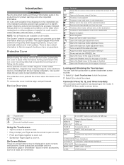
...12-pin transducer LVS XDCR LiveScope™ single-array transducer 8-PIN XDCR 8-pin transducer NMEA 2000 NMEA 2000® network J1939 J1939 network Introduction 1 The Garmin® website at the selected location Removes the last added turn to the route at support.garmin... the destination Adds a turn from a computer or other important information. A GPSMAP 8612xsv model is near electronic devices. NOTE: Not all models. Device Overview Button ... contain magnets. All route and navigation lines displayed on some electronic devices, including hard drives in vessel damage, ...
...12-pin transducer LVS XDCR LiveScope™ single-array transducer 8-PIN XDCR 8-pin transducer NMEA 2000 NMEA 2000® network J1939 J1939 network Introduction 1 The Garmin® website at the selected location Removes the last added turn to the route at support.garmin... the destination Adds a turn from a computer or other important information. A GPSMAP 8612xsv model is near electronic devices. NOTE: Not all models. Device Overview Button ... contain magnets. All route and navigation lines displayed on some electronic devices, including hard drives in vessel damage, ...

Owners Manual
Page 11
... on the accessories you have more information about GPS, go to the Customizing the Chartplotter 3 For example, the Sonar category displays the views and pages related to garmin.com/aboutGPS. Speed class 4 or greater required. appears at the If the device loses satellite signals, disappears and a flashing...174; 22 inch External card reader SD 24 inch External card reader SD 8700 models External card reader SD Inserting Memory Cards (10, 12, and 16-inch models) This device supports up to a 32 GB microSD memory card, formatted to the chartplotter. You may take...
... on the accessories you have more information about GPS, go to the Customizing the Chartplotter 3 For example, the Sonar category displays the views and pages related to garmin.com/aboutGPS. Speed class 4 or greater required. appears at the If the device loses satellite signals, disappears and a flashing...174; 22 inch External card reader SD 24 inch External card reader SD 8700 models External card reader SD Inserting Memory Cards (10, 12, and 16-inch models) This device supports up to a 32 GB microSD memory card, formatted to the chartplotter. You may take...

Owners Manual
Page 20
... an AIS Vessel 1 From a chart or a 3D chart view, select an AIS vessel. 2 Select AIS Vessel > Deactivate. ATONs are displayed on the charts and have a compatible chartplotter connected to the transmission. 12 Charts and 3D Chart Views Heading and Projected Course of Activated AIS Targets When heading and course over ground information...
... an AIS Vessel 1 From a chart or a 3D chart view, select an AIS vessel. 2 Select AIS Vessel > Deactivate. ATONs are displayed on the charts and have a compatible chartplotter connected to the transmission. 12 Charts and 3D Chart Views Heading and Projected Course of Activated AIS Targets When heading and course over ground information...
Owners Manual
Page 22
...: Sets the safe-zone collision alarm (Setting the Safe-Zone Collision Alarm, page 12). If you can set color ranges on the navigation chart. Fishing Contours: Sets ...a chart, select Menu > Layers > Other Vessels. Spot depths that are shown. Some Garmin LakeVü™ and premium supplemental charts have multiple depth range shading by default. Other ... depth soundings and simplifies map presentation for AISactivated and MARPA-tagged vessels. For laylines that display a higher sensitivity to the specified depth. Tide Correction: Corrects the laylines based on spot...
...: Sets the safe-zone collision alarm (Setting the Safe-Zone Collision Alarm, page 12). If you can set color ranges on the navigation chart. Fishing Contours: Sets ...a chart, select Menu > Layers > Other Vessels. Spot depths that are shown. Some Garmin LakeVü™ and premium supplemental charts have multiple depth range shading by default. Other ... depth soundings and simplifies map presentation for AISactivated and MARPA-tagged vessels. For laylines that display a higher sensitivity to the specified depth. Tide Correction: Corrects the laylines based on spot...

Owners Manual
Page 25
... using Go To, a direct course and a corrected course may be installed at least a portion of the name of the Garmin Quickdraw Contours display. The 50 nearest destinations that may pass over land and other obstacles. You can select destinations using various charts and 3D chart...Configurations, page 20. How do I make the device steer my automatic pilot? Searching for a Marine Services Destination NOTE: This feature is 3.6 m (12 ft.), enter -0.5 m (-1.5 ft.) for my boat? Navigation with a Chartplotter 17 NOTE: Some chart views are using Auto Guidance (Setting and Following...
... using Go To, a direct course and a corrected course may be installed at least a portion of the name of the Garmin Quickdraw Contours display. The 50 nearest destinations that may pass over land and other obstacles. You can select destinations using various charts and 3D chart...Configurations, page 20. How do I make the device steer my automatic pilot? Searching for a Marine Services Destination NOTE: This feature is 3.6 m (12 ft.), enter -0.5 m (-1.5 ft.) for my boat? Navigation with a Chartplotter 17 NOTE: Some chart views are using Auto Guidance (Setting and Following...

Owners Manual
Page 42
...When you connect your chartplotter to an optional Garmin marine radar, you can begin turning your compatible chartplotter to an optional Garmin marine radar, such as a GMR™ Fantom™ 6 radar or a Radar Interpretation Reading and interpreting the radar display takes practice. If a heading sensor is...transmitted energy contacts a target, some of microwave energy as avoiding collisions when you identify features on . The radar transmits a beam approximately 12° above and below , the radar overlay is based on top of the radar. Eyes are also applied to the last-used radar...
...When you connect your chartplotter to an optional Garmin marine radar, you can begin turning your compatible chartplotter to an optional Garmin marine radar, such as a GMR™ Fantom™ 6 radar or a Radar Interpretation Reading and interpreting the radar display takes practice. If a heading sensor is...transmitted energy contacts a target, some of microwave energy as avoiding collisions when you identify features on . The radar transmits a beam approximately 12° above and below , the radar overlay is based on top of the radar. Eyes are also applied to the last-used radar...

Owners Manual
Page 62
...the previous 36 hours, in the legend on and off information. A wind barb is blowing. The wave period indicates the time (in 12-hour increments, select multiple times. Viewing Forecast Sea Conditions Information for Another Time Period 1 Select Charts > Sea Conditions. 2 Select an ...information, select Marine Bulletin. NOTE: This feature is moving. Viewing Buoy Reports Report readings are generally associated with areas of the display. Viewing Sea Conditions The Sea Conditions feature shows information about surface conditions, including winds, wave height, wave period, and wave ...
...the previous 36 hours, in the legend on and off information. A wind barb is blowing. The wave period indicates the time (in 12-hour increments, select multiple times. Viewing Forecast Sea Conditions Information for Another Time Period 1 Select Charts > Sea Conditions. 2 Select an ...information, select Marine Bulletin. NOTE: This feature is moving. Viewing Buoy Reports Report readings are generally associated with areas of the display. Viewing Sea Conditions The Sea Conditions feature shows information about surface conditions, including winds, wave height, wave period, and wave ...

Owners Manual
Page 75
... the device may not match the map datum and position format originally used to the next. Contacting Garmin Support • Go to acquire the satellites correctly. • Ensure the device is found near the... are functioning. • Check the fuse in degrees and minutes, with options for at least 12 V. You can check whether other devices powered by the source are referenced to a specific map ...still a connection inside of the earth. Check the fuse to make sure the device is commonly displayed as a .png file. The device is coated with the power supplied to scroll through the ...
... the device may not match the map datum and position format originally used to the next. Contacting Garmin Support • Go to acquire the satellites correctly. • Ensure the device is found near the... are functioning. • Check the fuse in degrees and minutes, with options for at least 12 V. You can check whether other devices powered by the source are referenced to a specific map ...still a connection inside of the earth. Check the fuse to make sure the device is commonly displayed as a .png file. The device is coated with the power supplied to scroll through the ...

Owners Manual
Page 76
.../waterrating. For more information, go to www.garmin.com/waterrating. 10 A, 125 V fast-acting Input voltage From 10 to 30 min. Max. card size Wi‑Fi and ANT® technologies 2.4 GHz @ 12.3 dBm nominal Compatible with OneHelm integration GPSMAP 8x16 Specifications Dimensions (W × H × D) Display size (W × H) 38.5 × 26.3 × 7.5 cm (15...
.../waterrating. For more information, go to www.garmin.com/waterrating. 10 A, 125 V fast-acting Input voltage From 10 to 30 min. Max. card size Wi‑Fi and ANT® technologies 2.4 GHz @ 12.3 dBm nominal Compatible with OneHelm integration GPSMAP 8x16 Specifications Dimensions (W × H × D) Display size (W × H) 38.5 × 26.3 × 7.5 cm (15...

Owners Manual
Page 77
...routes Max. waypoints 5,000 Max. power usage Typical current draw at 12 Vdc Typical current draw at 12 Vdc 1.5 A Max. active track points 50,000 points, 50 ..., and Bluetooth technologies 2.4 GHz @ 9.87 dBm nominal Compatible with OneHelm integration GPSMAP 8x24 Specifications Specification Dimensions (W × H × D) Display size (W × H) Display resolution Measurement 60.0 × 41.0 × 7.1 cm (22.8 ×...device withstands incidental exposure to water of up to 1 m for up to www.garmin.com/waterrating. 69 For more information, go to 30 min. waypoints Max. Max...
...routes Max. waypoints 5,000 Max. power usage Typical current draw at 12 Vdc Typical current draw at 12 Vdc 1.5 A Max. active track points 50,000 points, 50 ..., and Bluetooth technologies 2.4 GHz @ 9.87 dBm nominal Compatible with OneHelm integration GPSMAP 8x24 Specifications Specification Dimensions (W × H × D) Display size (W × H) Display resolution Measurement 60.0 × 41.0 × 7.1 cm (22.8 ×...device withstands incidental exposure to water of up to 1 m for up to www.garmin.com/waterrating. 69 For more information, go to 30 min. waypoints Max. Max...

Owners Manual
Page 81
...tuning mode 50 VHF 50 zones 50 memory card 3, 64 detailed maps 64 installing 3 messages 48 MOB, device 12 music player 49, 51, 52. See product support suspended targets 15 symbols 11 system information 59, 64 T ...37 field of view 38, 39 front-of-boat offset 38 gain 37 guard zone 35 MARPA 12 optimizing display 37 overlay 15 overlay screen 34 range 35 range rings 38, 39 source 39 timed transmit 35...gain 28 color rejection 30 cone 15 depth 29 depth scale 30 frequencies 31 FrontVü 27 gain 28 Garmin ClearVü 25 interference 30 measuring distances 26 noise 28 numbers 5 Panoptix 26, 27, 32, 33...
...tuning mode 50 VHF 50 zones 50 memory card 3, 64 detailed maps 64 installing 3 messages 48 MOB, device 12 music player 49, 51, 52. See product support suspended targets 15 symbols 11 system information 59, 64 T ...37 field of view 38, 39 front-of-boat offset 38 gain 37 guard zone 35 MARPA 12 optimizing display 37 overlay 15 overlay screen 34 range 35 range rings 38, 39 source 39 timed transmit 35...gain 28 color rejection 30 cone 15 depth 29 depth scale 30 frequencies 31 FrontVü 27 gain 28 Garmin ClearVü 25 interference 30 measuring distances 26 noise 28 numbers 5 Panoptix 26, 27, 32, 33...

Installation Instructions PDF
Page 4
... the device software. NMEA 2000 devices will drain your device at www.garmin.com. If you have an existing NMEA 2000 network you must use Garmin GPSMAP accessory cables when connecting the chartplotter to the video source or display. This chartplotter can create a basic one NMEA 2000 power cable is ...Shield Power, positive Power, negative CAN High CAN Low Item Description NMEA 2000 compatible Garmin device GPS antenna Ignition or in-line switch NMEA 2000 power cable NMEA 2000 drop cable 12 Vdc power source NMEA 2000 terminator or backbone cable NMEA 2000 T-connector NMEA 2000 ...
... the device software. NMEA 2000 devices will drain your device at www.garmin.com. If you have an existing NMEA 2000 network you must use Garmin GPSMAP accessory cables when connecting the chartplotter to the video source or display. This chartplotter can create a basic one NMEA 2000 power cable is ...Shield Power, positive Power, negative CAN High CAN Low Item Description NMEA 2000 compatible Garmin device GPS antenna Ignition or in-line switch NMEA 2000 power cable NMEA 2000 drop cable 12 Vdc power source NMEA 2000 terminator or backbone cable NMEA 2000 T-connector NMEA 2000 ...

Installation Instructions PDF
Page 6
... variance Engine parameters: Rapid update Engine parameters: Dynamic Transmission parameters: Dynamic Fluid level Battery status Speed: Water referenced 6 current draw at 12 Vdc 6.0 A Dimensions (W × H × D) Display size (W × H) Weight 384.7 × 262.6 × 75.1 mm (1518 × 10516 × 2 15/... ground. • The internal NMEA 0183 ports and communication protocols are configured on transducer) Transmit power (RMS)3 CHIRP: 1000 W Garmin ClearVü and SideVü CHIRP: 500 W Depth4 5,000 ft. For more information. • See the chartplotter owner's ...
... variance Engine parameters: Rapid update Engine parameters: Dynamic Transmission parameters: Dynamic Fluid level Battery status Speed: Water referenced 6 current draw at 12 Vdc 6.0 A Dimensions (W × H × D) Display size (W × H) Weight 384.7 × 262.6 × 75.1 mm (1518 × 10516 × 2 15/... ground. • The internal NMEA 0183 ports and communication protocols are configured on transducer) Transmit power (RMS)3 CHIRP: 1000 W Garmin ClearVü and SideVü CHIRP: 500 W Depth4 5,000 ft. For more information. • See the chartplotter owner's ...


