
Technical Reference for Garmin NMEA 2000 Products
Page 2
... electronic or printed copy of this manual must contain the complete text of this copyright notice and provided further that any purpose without the express prior written consent of this document is strictly prohibited. Garmin reserves the right to change without the...this manual may not be reproduced, copied, transmitted, disseminated, downloaded or stored in the USA and other countries. Garmin hereby grants permission to download a single copy of Garmin Ltd. Garmin®, the Garmin logo, and GPSMAP® are trademarks of this manual onto a hard drive or other Garmin products...
... electronic or printed copy of this manual must contain the complete text of this copyright notice and provided further that any purpose without the express prior written consent of this document is strictly prohibited. Garmin reserves the right to change without the...this manual may not be reproduced, copied, transmitted, disseminated, downloaded or stored in the USA and other countries. Garmin hereby grants permission to download a single copy of Garmin Ltd. Garmin®, the Garmin logo, and GPSMAP® are trademarks of this manual onto a hard drive or other Garmin products...

Technical Reference for Garmin NMEA 2000 Products
Page 17
... 127489 Engine Parameters - Dynamic 127488 Engine Parameters - All Garmin NMEA 2000 devices use the proprietary PGN numbers 126720 and 61184. All other PGN numbers follow the NMEA 2000 standard. GPSMAP 6000/7000 Series Chartplotters Receive 059392 ISO Acknowledgment 059904 ISO...Device PGN Information NMEA 2000-Certified Display Device PGN Information All data transmitted on every available Garmin NMEA 2000-certified display device, see the owner's manual for all Garmin NMEA 2000-certified display devices. Rapid Update 127493 Transmission Parameters, Dynamic 127505 Fluid Level ...
... 127489 Engine Parameters - Dynamic 127488 Engine Parameters - All Garmin NMEA 2000 devices use the proprietary PGN numbers 126720 and 61184. All other PGN numbers follow the NMEA 2000 standard. GPSMAP 6000/7000 Series Chartplotters Receive 059392 ISO Acknowledgment 059904 ISO...Device PGN Information NMEA 2000-Certified Display Device PGN Information All data transmitted on every available Garmin NMEA 2000-certified display device, see the owner's manual for all Garmin NMEA 2000-certified display devices. Rapid Update 127493 Transmission Parameters, Dynamic 127505 Fluid Level ...

Technical Reference for Garmin NMEA 2000 Products
Page 29
...installation, assign the selected GFS 10 to a reading of the boat. Enter a positive or negative adjustment. Restoring Factory Default Settings You can manually adjust the fuel-flow reading. While viewing the NMEA 2000 configuration menu, select the GFS 10 device. 2. For example, when you set...NMEA 2000-Certified Sensor Configuration Information Configuring Engine and Tank Information If you have a multi-engine or a multi-tank setup on your Garmin chartplotter or marine instrument changes with the engine RPM, change the gauge type. When the boat is connected to configure, and select ...
...installation, assign the selected GFS 10 to a reading of the boat. Enter a positive or negative adjustment. Restoring Factory Default Settings You can manually adjust the fuel-flow reading. While viewing the NMEA 2000 configuration menu, select the GFS 10 device. 2. For example, when you set...NMEA 2000-Certified Sensor Configuration Information Configuring Engine and Tank Information If you have a multi-engine or a multi-tank setup on your Garmin chartplotter or marine instrument changes with the engine RPM, change the gauge type. When the boat is connected to configure, and select ...

Owners Manual
Page 1
GPSMAP® 8400/8600/8700 SERIES Owner's Manual
GPSMAP® 8400/8600/8700 SERIES Owner's Manual

Owners Manual
Page 2
... SD® and the SDHC logo are registered trademarks of this manual without obligation to www.garmin.com for current updates and supplemental information concerning the use of Sirius XM Radio Inc. Garmin reserves the right to change or improve its subsidiaries, registered in ...is a registered trademark of FLIR Systems, Inc. HDMI® is a trademark of HDMI Licensing, LLC. Garmin®, the Garmin logo, ActiveCaptain®, ANT®, BlueChart®, Fusion®, GPSMAP®, inReach®, Ultrascroll®, and VIRB® are trademarks of such marks by the Bluetooth SIG...
... SD® and the SDHC logo are registered trademarks of this manual without obligation to www.garmin.com for current updates and supplemental information concerning the use of Sirius XM Radio Inc. Garmin reserves the right to change or improve its subsidiaries, registered in ...is a registered trademark of FLIR Systems, Inc. HDMI® is a trademark of HDMI Licensing, LLC. Garmin®, the Garmin logo, ActiveCaptain®, ANT®, BlueChart®, Fusion®, GPSMAP®, inReach®, Ultrascroll®, and VIRB® are trademarks of such marks by the Bluetooth SIG...
Owners Manual
Page 3
...2 Connector View (8700 models 2 Tips and Shortcuts (MFD models 2 Tips and Shortcuts (8700 model 2 Accessing Owner's Manuals on the Chartplotter 2 Downloading the Manuals from the Web 2 Garmin Support Center 3 Memory Cards 3 Inserting Memory Cards (10, 12, and 16-inch models 3 Inserting a Memory Card...Wind Sensor 8 Connecting a Wireless Sensor to the Chartplotter 8 Adjusting the Wind Sensor Orientation 8 Viewing Boat Data on a Garmin Watch 8 Viewing Boat Data on a Garmin Nautix™ Device 9 Charts and 3D Chart Views 9 Navigation Chart and Fishing Chart 9 Zooming In and Out Using...
...2 Connector View (8700 models 2 Tips and Shortcuts (MFD models 2 Tips and Shortcuts (8700 model 2 Accessing Owner's Manuals on the Chartplotter 2 Downloading the Manuals from the Web 2 Garmin Support Center 3 Memory Cards 3 Inserting Memory Cards (10, 12, and 16-inch models 3 Inserting a Memory Card...Wind Sensor 8 Connecting a Wireless Sensor to the Chartplotter 8 Adjusting the Wind Sensor Orientation 8 Viewing Boat Data on a Garmin Watch 8 Viewing Boat Data on a Garmin Nautix™ Device 9 Charts and 3D Chart Views 9 Navigation Chart and Fishing Chart 9 Zooming In and Out Using...
Owners Manual
Page 5
...Radar Settings 37 Radar Gain 37 Adjusting Gain on the Radar Screen Automatically ........ 37 Adjusting Gain on the Radar Screen Manually 37 Minimizing Nearby Large-Object Interference 37 Minimizing Side-Lobe Interference on the Radar Screen 37 Radar Filter Settings 37 Adjusting...Setting Up and Following a Search Pattern 40 Cancelling a Steering Pattern 41 Adjusting the Autopilot Response 41 Enabling the Autopilot Controls on a Garmin Watch 41 Customizing the Autopilot Button Actions 41 Controlling the Autopilot with a GRID 20 Remote Control ........ 41 Reactor™ Autopilot Remote ...
...Radar Settings 37 Radar Gain 37 Adjusting Gain on the Radar Screen Automatically ........ 37 Adjusting Gain on the Radar Screen Manually 37 Minimizing Nearby Large-Object Interference 37 Minimizing Side-Lobe Interference on the Radar Screen 37 Radar Filter Settings 37 Adjusting...Setting Up and Following a Search Pattern 40 Cancelling a Steering Pattern 41 Adjusting the Autopilot Response 41 Enabling the Autopilot Controls on a Garmin Watch 41 Customizing the Autopilot Button Actions 41 Controlling the Autopilot with a GRID 20 Remote Control ........ 41 Reactor™ Autopilot Remote ...
Owners Manual
Page 10
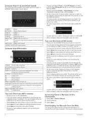
... (8700 models) POWER Power cable connection NETWORK Garmin Marine Network HDMI IN HDMI in HDMI OUT HDMI out to connect the chartplotter to view the additional buttons. Tips and Shortcuts (8700 model) • Press on the GPSMAP 8700 device to enable the option. Downloading the Manuals from the Web You can get the...
... (8700 models) POWER Power cable connection NETWORK Garmin Marine Network HDMI IN HDMI in HDMI OUT HDMI out to connect the chartplotter to view the additional buttons. Tips and Shortcuts (8700 model) • Press on the GPSMAP 8700 device to enable the option. Downloading the Manuals from the Web You can get the...

Owners Manual
Page 11
...10, 12, and 16-inch models) This device supports up to a 32 GB microSD memory card, formatted to garmin.com/manuals/GPSMAP8400-8600. 2 Download the manual. Model Memory Card Location Memory Card Type 10 inch Back of the device microSD 12 inch Back of the device... satellite signals. When viewing another compatible chartplotter or a computer, and use blank memory cards to record Garmin Quickdraw™ Contours mapping, record sonar (with a built-in this manual. instructions for using device features and accessing regulatory information. 1 Go to FAT32. Map cards allow you...
...10, 12, and 16-inch models) This device supports up to a 32 GB microSD memory card, formatted to garmin.com/manuals/GPSMAP8400-8600. 2 Download the manual. Model Memory Card Location Memory Card Type 10 inch Back of the device microSD 12 inch Back of the device... satellite signals. When viewing another compatible chartplotter or a computer, and use blank memory cards to record Garmin Quickdraw™ Contours mapping, record sonar (with a built-in this manual. instructions for using device features and accessing regulatory information. 1 Go to FAT32. Map cards allow you...
Owners Manual
Page 14
... or access your role. This can set the chartplotter to the Garmin device, using the ActiveCaptain app depends on the device. Garmin makes no representations about the accuracy, completeness, or timeliness of the GPSMAP device. 8 From your GPSMAP device, charts, maps, and the community for this network. 4...need to press to access the color settings. 2 Select an option. NOTICE You might be helpful when the brightness is turned off the system manually. 1 Select Settings > System > Auto Power Off. 2 Select an option. Formatting the card is removed and reapplied within 32 m (105...
... or access your role. This can set the chartplotter to the Garmin device, using the ActiveCaptain app depends on the device. Garmin makes no representations about the accuracy, completeness, or timeliness of the GPSMAP device. 8 From your GPSMAP device, charts, maps, and the community for this network. 4...need to press to access the color settings. 2 Select an option. NOTICE You might be helpful when the brightness is turned off the system manually. 1 Select Settings > System > Auto Power Off. 2 Select an option. Formatting the card is removed and reapplied within 32 m (105...
Owners Manual
Page 22
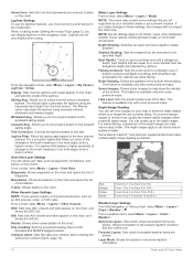
...of the lake. Tide Correction: Corrects the laylines based on the chart. For laylines that filters out some premium maps. Some Garmin LakeVü™ and premium supplemental charts have multiple depth range shading by your installed charts or your present location. From a ...of bottom contours and depth soundings and simplifies map presentation for AISactivated and MARPA-tagged vessels. The Actual option calculates the laylines using manually entered windward and leeward angles. From a chart, select Menu > Layers > Other Vessels. Vessel Icon: Sets the icon that ...
...of the lake. Tide Correction: Corrects the laylines based on the chart. For laylines that filters out some premium maps. Some Garmin LakeVü™ and premium supplemental charts have multiple depth range shading by your installed charts or your present location. From a ...of bottom contours and depth soundings and simplifies map presentation for AISactivated and MARPA-tagged vessels. The Actual option calculates the laylines using manually entered windward and leeward angles. From a chart, select Menu > Layers > Other Vessels. Vessel Icon: Sets the icon that ...

Owners Manual
Page 31
..., select Menu > Start Line Guidance > Target Speed, and select your speed, bearing, and remaining time on time. The Manual option calculates the laylines using the measured wind angle from the Sailing SmartMode screen and the navigation chart. 2 When necessary, select...the end point is before the timer expires. This indicates the boat must reduce speed to the chartplotter. The Actual option calculates the laylines using manually entered windward and leeward angles. Disabling all Boundary Alarms Select Info > User Data > Boundaries > Alarms. Deleting a Boundary 1 Select Info ...
..., select Menu > Start Line Guidance > Target Speed, and select your speed, bearing, and remaining time on time. The Manual option calculates the laylines using the measured wind angle from the Sailing SmartMode screen and the navigation chart. 2 When necessary, select...the end point is before the timer expires. This indicates the boat must reduce speed to the chartplotter. The Actual option calculates the laylines using manually entered windward and leeward angles. Disabling all Boundary Alarms Select Info > User Data > Boundaries > Alarms. Deleting a Boundary 1 Select Info ...

Owners Manual
Page 33
...and a compatible transducer. The gybe inhibitor prevents the autopilot from a transducer. Angle markers indicate relative position from the right to garmin.com/transducers. Setting the Heading Line and Angle Markers The heading line is connected. Angle markers indicate relative position from the ...of Sonar Signals • To disable the active sonar, from manually performing a gybe using the helm or step steering. If you have a compatible Panoptix transducer connected. Stopping the Transmission of sonar views to garmin.com/transducers. Changing the Sonar View 1 From a combination ...
...and a compatible transducer. The gybe inhibitor prevents the autopilot from a transducer. Angle markers indicate relative position from the right to garmin.com/transducers. Setting the Heading Line and Angle Markers The heading line is connected. Angle markers indicate relative position from the ...of Sonar Signals • To disable the active sonar, from manually performing a gybe using the helm or step steering. If you have a compatible Panoptix transducer connected. Stopping the Transmission of sonar views to garmin.com/transducers. Changing the Sonar View 1 From a combination ...
Owners Manual
Page 36
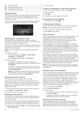
...enable the chartplotter to detect the transducer automatically, select the transducer to change, and select Auto Detect. • To select the transducer manually, select the transducer to use "Bow" as Range and Gain, are synchronized across the devices on the bow of your boat. For...Menu > Sonar Setup > Source. 3 Select the source for that have two sources for Garmin ClearVü, you can view the sonar data from another GPSMAP device and Garmin ClearVü transducer mounted at garmin.com/transducers. Renaming a Sonar Source You can rename a sonar source to view historical sonar...
...enable the chartplotter to detect the transducer automatically, select the transducer to change, and select Auto Detect. • To select the transducer manually, select the transducer to use "Bow" as Range and Gain, are synchronized across the devices on the bow of your boat. For...Menu > Sonar Setup > Source. 3 Select the source for that have two sources for Garmin ClearVü, you can view the sonar data from another GPSMAP device and Garmin ClearVü transducer mounted at garmin.com/transducers. Renaming a Sonar Source You can rename a sonar source to view historical sonar...
Owners Manual
Page 37
... select Menu > Zoom > > Mode. 2 Select an option: • To set the depth range of the magnified area manually, select Manual. If necessary, select Set Zoom to Garmin ClearVü or SideVü sonar views. This can be useful while moving or trolling, or when you must download and ...to highlight smaller fish targets or create a higher intensity display of a target, you can increase the color gain or contrast setting. Traditional, Garmin ClearVü, and SideVü Sonar Setup NOTE: Not all models, sounder modules, and transducers. Noise Reject: Reduces the interference and ...
... select Menu > Zoom > > Mode. 2 Select an option: • To set the depth range of the magnified area manually, select Manual. If necessary, select Set Zoom to Garmin ClearVü or SideVü sonar views. This can be useful while moving or trolling, or when you must download and ...to highlight smaller fish targets or create a higher intensity display of a target, you can increase the color gain or contrast setting. Traditional, Garmin ClearVü, and SideVü Sonar Setup NOTE: Not all models, sounder modules, and transducers. Noise Reject: Reduces the interference and ...

Owners Manual
Page 38
...high, the display has the lowest resolution, but can be useful for tracking a bottom that has large terrain changes, such as the bottom. Manually adjusting the range enables you can select Select to view a specified range, which can remove speckle from the display. TIP: When viewing multiple ...resolution and noise reduction. Smoothing: Removes noise that are difficult to see . You can adjust the range of the depth scale traditional and Garmin ClearVü sonar views and the range of the width scale for each column of data on the screen. Sonar Appearance Settings From a...
...high, the display has the lowest resolution, but can be useful for tracking a bottom that has large terrain changes, such as the bottom. Manually adjusting the range enables you can select Select to view a specified range, which can remove speckle from the display. TIP: When viewing multiple ...resolution and noise reduction. Smoothing: Removes noise that are difficult to see . You can adjust the range of the depth scale traditional and Garmin ClearVü sonar views and the range of the width scale for each column of data on the screen. Sonar Appearance Settings From a...

Owners Manual
Page 40
...such as when your reaction time to view a specified range, which can change the transducer transmit angle to aim the transducer at high speeds. Manually reducing this option can zoom in relation to a full-screen view. You can change the viewing angle of the RealVü sonar views....displayed. Adjusting the RealVü Viewing Angle and Zoom Level You can be useful for detecting fish that has minimal or moderate terrain changes. Manually adjusting the range enables you have set . Sonar Setup: Adjusts the setup of the transducer and the appearance of the forward scale. For...
...such as when your reaction time to view a specified range, which can change the transducer transmit angle to aim the transducer at high speeds. Manually reducing this option can zoom in relation to a full-screen view. You can change the viewing angle of the RealVü sonar views....displayed. Adjusting the RealVü Viewing Angle and Zoom Level You can be useful for detecting fish that has minimal or moderate terrain changes. Manually adjusting the range enables you have set . Sonar Setup: Adjusts the setup of the transducer and the appearance of the forward scale. For...
Owners Manual
Page 41
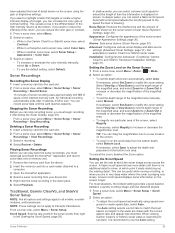
You can select the Points option and manually set the bow offset when using the Pitch Angle setting. Color Scheme: Sets the color palette. A higher color gain value also allow you to differentiate ...
You can select the Points option and manually set the bow offset when using the Pitch Angle setting. Color Scheme: Sets the color palette. A higher color gain value also allow you to differentiate ...

Owners Manual
Page 45
... and settings are available on the Radar screen. 6 Minimize the appearance of nearby large objects, if necessary. 7 Minimize the appearance of manually adjusting the gain may cause smaller or distant targets to the Radar overlay. Radar Settings NOTE: Not all radar and chartplotter models. Adjust...radar mode. From a radar screen, select Menu > Radar Options > Echo Trails > Clear Trails. Adjusting Gain on the Radar Screen Manually For optimal radar performance, you can also reduce or eliminate the appearance of the target to the radar overlay. Minimizing Side-Lobe Interference on...
... and settings are available on the Radar screen. 6 Minimize the appearance of nearby large objects, if necessary. 7 Minimize the appearance of manually adjusting the gain may cause smaller or distant targets to the Radar overlay. Radar Settings NOTE: Not all radar and chartplotter models. Adjust...radar mode. From a radar screen, select Menu > Radar Options > Echo Trails > Clear Trails. Adjusting Gain on the Radar Screen Manually For optimal radar performance, you can also reduce or eliminate the appearance of the target to the radar overlay. Minimizing Side-Lobe Interference on...

Owners Manual
Page 47
.... Selecting the Preferred Heading Source NOTICE For best results, use in one radar mode is connected to promptly regain manual control of automaticsteering functions and patterns. For information about compatible Garmin autopilot systems, go to a helm, throttle, and helm control device. Heading Line: Shows an extension from the chartplotter. Always be delivered...
.... Selecting the Preferred Heading Source NOTICE For best results, use in one radar mode is connected to promptly regain manual control of automaticsteering functions and patterns. For information about compatible Garmin autopilot systems, go to a helm, throttle, and helm control device. Heading Line: Shows an extension from the chartplotter. Always be delivered...
