
Technical Reference for Garmin NMEA 2000 Products
Page 2
... products and to be used without notice. Garmin®, the Garmin logo, and GPSMAP® are trademarks of this document is strictly prohibited. These trademarks may be reproduced, copied, transmitted, disseminated, downloaded or stored in the USA and other electronic storage medium to make changes in this manual onto a hard drive or other countries...
... products and to be used without notice. Garmin®, the Garmin logo, and GPSMAP® are trademarks of this document is strictly prohibited. These trademarks may be reproduced, copied, transmitted, disseminated, downloaded or stored in the USA and other electronic storage medium to make changes in this manual onto a hard drive or other countries...

Technical Reference for Garmin NMEA 2000 Products
Page 17
...Compatible Display Device PGN Information NMEA 2000-Certified Display Device PGN Information All data transmitted on every available Garmin NMEA 2000-certified display device, see the owner's manual for your display device. All other PGN numbers follow the NMEA 2000 standard. Rapid Update 129026 COG...Info GNSS Sats in View Wind Data Temperature Technical Reference for all Garmin NMEA 2000-certified display devices. All Garmin NMEA 2000 devices use the proprietary PGN numbers 126720 and 61184. GPSMAP 6000/7000 Series Chartplotters Receive 059392 ISO Acknowledgment 059904 ISO Request ...
...Compatible Display Device PGN Information NMEA 2000-Certified Display Device PGN Information All data transmitted on every available Garmin NMEA 2000-certified display device, see the owner's manual for your display device. All other PGN numbers follow the NMEA 2000 standard. Rapid Update 129026 COG...Info GNSS Sats in View Wind Data Temperature Technical Reference for all Garmin NMEA 2000-certified display devices. All Garmin NMEA 2000 devices use the proprietary PGN numbers 126720 and 61184. GPSMAP 6000/7000 Series Chartplotters Receive 059392 ISO Acknowledgment 059904 ISO Request ...

Technical Reference for Garmin NMEA 2000 Products
Page 29
...engine in neutral. 2. While viewing the NMEA 2000 device configuration menu, select the GFS 10 device. 2. Restoring Factory Default Settings You can manually adjust the fuel-flow reading. To restore factory default settings: 1. If the fuel-level reading changes with the motion of gauge. Select ..., when you have a multi-engine or a multi-tank setup on your boat, specify which engine or tank is shown on your Garmin chartplotter or marine instrument changes with each GFS 10. Select from the GFS 10 appears inaccurate, you can restore factory default settings to increase...
...engine in neutral. 2. While viewing the NMEA 2000 device configuration menu, select the GFS 10 device. 2. Restoring Factory Default Settings You can manually adjust the fuel-flow reading. To restore factory default settings: 1. If the fuel-level reading changes with the motion of gauge. Select ..., when you have a multi-engine or a multi-tank setup on your boat, specify which engine or tank is shown on your Garmin chartplotter or marine instrument changes with each GFS 10. Select from the GFS 10 appears inaccurate, you can restore factory default settings to increase...

Owners Manual
Page 1
GPSMAP® 8400/8600/8700 SERIES Owner's Manual
GPSMAP® 8400/8600/8700 SERIES Owner's Manual

Owners Manual
Page 2
...laws, this manual may not be copied, in whole or in part, without the express permission of Garmin. Garmin®, the Garmin logo, ActiveCaptain®, ANT®, BlueChart®, Fusion®, GPSMAP®, inReach®, Ultrascroll®, and VIRB® are registered trademarks of Garmin. These trademarks ... countries. Windows® is a registered trademark of FLIR Systems, Inc. Go to notify any use of this manual without obligation to www.garmin.com for current updates and supplemental information concerning the use of FLIR Systems, Inc. The BLUETOOTH® word mark...
...laws, this manual may not be copied, in whole or in part, without the express permission of Garmin. Garmin®, the Garmin logo, ActiveCaptain®, ANT®, BlueChart®, Fusion®, GPSMAP®, inReach®, Ultrascroll®, and VIRB® are registered trademarks of Garmin. These trademarks ... countries. Windows® is a registered trademark of FLIR Systems, Inc. Go to notify any use of this manual without obligation to www.garmin.com for current updates and supplemental information concerning the use of FLIR Systems, Inc. The BLUETOOTH® word mark...
Owners Manual
Page 3
...2 Connector View (8700 models 2 Tips and Shortcuts (MFD models 2 Tips and Shortcuts (8700 model 2 Accessing Owner's Manuals on the Chartplotter 2 Downloading the Manuals from the Web 2 Garmin Support Center 3 Memory Cards 3 Inserting Memory Cards (10, 12, and 16-inch models 3 Inserting a Memory Card...Wind Sensor 8 Connecting a Wireless Sensor to the Chartplotter 8 Adjusting the Wind Sensor Orientation 8 Viewing Boat Data on a Garmin Watch 8 Viewing Boat Data on a Garmin Nautix™ Device 9 Charts and 3D Chart Views 9 Navigation Chart and Fishing Chart 9 Zooming In and Out Using...
...2 Connector View (8700 models 2 Tips and Shortcuts (MFD models 2 Tips and Shortcuts (8700 model 2 Accessing Owner's Manuals on the Chartplotter 2 Downloading the Manuals from the Web 2 Garmin Support Center 3 Memory Cards 3 Inserting Memory Cards (10, 12, and 16-inch models 3 Inserting a Memory Card...Wind Sensor 8 Connecting a Wireless Sensor to the Chartplotter 8 Adjusting the Wind Sensor Orientation 8 Viewing Boat Data on a Garmin Watch 8 Viewing Boat Data on a Garmin Nautix™ Device 9 Charts and 3D Chart Views 9 Navigation Chart and Fishing Chart 9 Zooming In and Out Using...
Owners Manual
Page 5
...Radar Settings 37 Radar Gain 37 Adjusting Gain on the Radar Screen Automatically ........ 37 Adjusting Gain on the Radar Screen Manually 37 Minimizing Nearby Large-Object Interference 37 Minimizing Side-Lobe Interference on the Radar Screen 37 Radar Filter Settings 37 Adjusting...Setting Up and Following a Search Pattern 40 Cancelling a Steering Pattern 41 Adjusting the Autopilot Response 41 Enabling the Autopilot Controls on a Garmin Watch 41 Customizing the Autopilot Button Actions 41 Controlling the Autopilot with a GRID 20 Remote Control ........ 41 Reactor™ Autopilot Remote ...
...Radar Settings 37 Radar Gain 37 Adjusting Gain on the Radar Screen Automatically ........ 37 Adjusting Gain on the Radar Screen Manually 37 Minimizing Nearby Large-Object Interference 37 Minimizing Side-Lobe Interference on the Radar Screen 37 Radar Filter Settings 37 Adjusting...Setting Up and Following a Search Pattern 40 Cancelling a Steering Pattern 41 Adjusting the Autopilot Response 41 Enabling the Autopilot Controls on a Garmin Watch 41 Customizing the Autopilot Button Actions 41 Controlling the Autopilot with a GRID 20 Remote Control ........ 41 Reactor™ Autopilot Remote ...
Owners Manual
Page 10
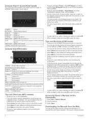
...can be helpful when the brightness is enabled . • When available, select the arrow to view the additional buttons. Downloading the Manuals from the Garmin website. The arrows at the top or bottom of the buttons indicate not all buttons are visible. • On some models, ...connectors and locations vary based upon the model. This can get the latest owner's manual and translations of the screen to a Garmin GMM monitor, a GRID remote, or a GRID 20 remote. The owner's manual includes 2 Introduction A GPSMAP 8622 model is so low you cannot see the screen. • On the ...
...can be helpful when the brightness is enabled . • When available, select the arrow to view the additional buttons. Downloading the Manuals from the Garmin website. The arrows at the top or bottom of the buttons indicate not all buttons are visible. • On some models, ...connectors and locations vary based upon the model. This can get the latest owner's manual and translations of the screen to a Garmin GMM monitor, a GRID remote, or a GRID 20 remote. The owner's manual includes 2 Introduction A GPSMAP 8622 model is so low you cannot see the screen. • On the ...

Owners Manual
Page 11
... Open the door on the device. 2 Wait while the device locates satellites. You may take 30 to 60 seconds to garmin.com/manuals/GPSMAP8400-8600. 2 Download the manual. When viewing another compatible chartplotter or a computer, and use the ActiveCaptain® app. Status bar Pages buttons Categories bar Menu...the card in until it clicks. 4 Press the weather cap firmly shut to record Garmin Quickdraw™ Contours mapping, record sonar (with the label facing away from the door. 3 Press the card in this manual. Speed class 4 or greater required. The time and date are dependant on the...
... Open the door on the device. 2 Wait while the device locates satellites. You may take 30 to 60 seconds to garmin.com/manuals/GPSMAP8400-8600. 2 Download the manual. When viewing another compatible chartplotter or a computer, and use the ActiveCaptain® app. Status bar Pages buttons Categories bar Menu...the card in until it clicks. 4 Press the weather cap firmly shut to record Garmin Quickdraw™ Contours mapping, record sonar (with the label facing away from the door. 3 Press the card in this manual. Speed class 4 or greater required. The time and date are dependant on the...
Owners Manual
Page 14
... 2 Enter a memorable numeric PIN of interest. On your mobile device with the GPSMAP device using the name and password you enable the Screen Lock feature, Garmin Support cannot retrieve the PIN or access your GPSMAP device, charts, maps, and the community for up recovery questions and answers as... Contours Community, and update device software. Formatting the card deletes all information saved on automatically when the power is turned off the system manually. 1 Select Settings > System > Auto Power Off. 2 Select an option. 2 Select an option. TIP: From any screen, press repeatedly to...
... 2 Enter a memorable numeric PIN of interest. On your mobile device with the GPSMAP device using the name and password you enable the Screen Lock feature, Garmin Support cannot retrieve the PIN or access your GPSMAP device, charts, maps, and the community for up recovery questions and answers as... Contours Community, and update device software. Formatting the card deletes all information saved on automatically when the power is turned off the system manually. 1 Select Settings > System > Auto Power Off. 2 Select an option. 2 Select an option. TIP: From any screen, press repeatedly to...
Owners Manual
Page 22
...Imagery: Shows sonar imagery to the chartplotter. You can show user data, such as an AIS receiver, radar, or VHF radio. Some Garmin LakeVü™ and premium supplemental charts have multiple depth range shading by your installed charts or your present location. From a weather ...fishing, a maximum of water. When in the boat's heading or true wind angle, enter a higher number. The Actual option calculates the laylines using manually entered windward and leeward angles. Tracks: Shows tracks on the tide. From a chart, select Menu > Layers > Other Vessels. Details: Shows other ...
...Imagery: Shows sonar imagery to the chartplotter. You can show user data, such as an AIS receiver, radar, or VHF radio. Some Garmin LakeVü™ and premium supplemental charts have multiple depth range shading by your installed charts or your present location. From a weather ...fishing, a maximum of water. When in the boat's heading or true wind angle, enter a higher number. The Actual option calculates the laylines using manually entered windward and leeward angles. Tracks: Shows tracks on the tide. From a chart, select Menu > Layers > Other Vessels. Details: Shows other ...

Owners Manual
Page 31
... layline based on time. Stopping the Race Timer From the Sail Racing combination screen, select Stop. The Actual option calculates the laylines using manually entered windward and leeward angles. Windward Ang.: Allows you are alerted at the optimal time and speed. Sail Racing You can use the ... the race timer with the official race timer. When the end point is white. When in the Sail Racing combination screen. The Manual option calculates the laylines using the measured wind angle from each pin. The predictor line extends from the Sailing SmartMode screen and the ...
... layline based on time. Stopping the Race Timer From the Sail Racing combination screen, select Stop. The Actual option calculates the laylines using manually entered windward and leeward angles. Windward Ang.: Allows you are alerted at the optimal time and speed. Sail Racing You can use the ... the race timer with the official race timer. When the end point is white. When in the Sail Racing combination screen. The Manual option calculates the laylines using the measured wind angle from each pin. The predictor line extends from the Sailing SmartMode screen and the ...

Owners Manual
Page 33
... Menu > Transmit. • To disable all sonar transmissions, press , and select Disable All Sonar Trans.. Sonar Fishfinder When properly connected to garmin.com/transducers. Traditional Sonar View There are helpful for your needs, go to a transducer, your needs, you view the fish in the screen...8482; sonar screens only if you need a compatible chartplotter or fishfinder and a compatible transducer. The gybe inhibitor prevents the autopilot from manually performing a gybe using the helm or step steering. Enabling the Gybe Inhibitor NOTE: The gybe inhibitor does not prevent you do not...
... Menu > Transmit. • To disable all sonar transmissions, press , and select Disable All Sonar Trans.. Sonar Fishfinder When properly connected to garmin.com/transducers. Traditional Sonar View There are helpful for your needs, go to a transducer, your needs, you view the fish in the screen...8482; sonar screens only if you need a compatible chartplotter or fishfinder and a compatible transducer. The gybe inhibitor prevents the autopilot from manually performing a gybe using the helm or step steering. Enabling the Gybe Inhibitor NOTE: The gybe inhibitor does not prevent you do not...
Owners Manual
Page 36
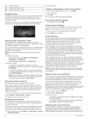
... This also increases noise, and can scroll the sonar display to change, select the transducer model from another GPSMAP device and Garmin ClearVü transducer mounted at garmin.com/transducers. Selecting the Transducer Type This chartplotter is best used to make the sonar function properly. For ... a sonar view, select Menu. 2 Select Gain or Brightness. 3 Select an option: • To increase or decrease the gain or brightness manually, select Up or Down. • To allow the chartplotter to remove lower intensity returns and noise. To see shorelines, fish, and structures. When...
... This also increases noise, and can scroll the sonar display to change, select the transducer model from another GPSMAP device and Garmin ClearVü transducer mounted at garmin.com/transducers. Selecting the Transducer Type This chartplotter is best used to make the sonar function properly. For ... a sonar view, select Menu. 2 Select Gain or Brightness. 3 Select an option: • To increase or decrease the gain or brightness manually, select Up or Down. • To allow the chartplotter to remove lower intensity returns and noise. To see shorelines, fish, and structures. When...
Owners Manual
Page 37
... magnification of the magnified area. • To magnify one particular area of the magnified area manually, select Manual. Select View Up or View Down to extend the length of time the information is pinging very slowly. When viewing Garmin ClearVü or SideVü sonar views or searching for structure, it starts stretching...
... magnification of the magnified area. • To magnify one particular area of the magnified area manually, select Manual. Select View Up or View Down to extend the length of time the information is pinging very slowly. When viewing Garmin ClearVü or SideVü sonar views or searching for structure, it starts stretching...

Owners Manual
Page 38
...Range. 2 Select an option: • To allow the chartplotter to adjust the range automatically, select Auto. • To increase or decrease the range manually, select Up or Down. From an applicable sonar view, select Menu > Sonar Setup > Alarms. You can adjust the interference and smoothing settings incrementally to ... > Appearance. Shows suspended targets as it easier to the transducer. Pic. You can adjust the range of the depth scale traditional and Garmin ClearVü sonar views and the range of the Depth or Width Scale You can use echo stretch and filter width together to noise....
...Range. 2 Select an option: • To allow the chartplotter to adjust the range automatically, select Auto. • To increase or decrease the range manually, select Up or Down. From an applicable sonar view, select Menu > Sonar Setup > Alarms. You can adjust the interference and smoothing settings incrementally to ... > Appearance. Shows suspended targets as it easier to the transducer. Pic. You can adjust the range of the depth scale traditional and Garmin ClearVü sonar views and the range of the Depth or Width Scale You can use echo stretch and filter width together to noise....

Owners Manual
Page 40
... see all return information, you what is available only with RealVü capable Panoptix transducers, such as the PS30, PS31, and PS60. Manually adjusting the range enables you can increase the hold time. Allowing the device to adjust the range automatically adjusts the forward scale in front of... Fishfinder This also increases noise, and can appear on the area. The bottom can make it appears within the range you have set . Manually reducing this option can use the a-scope to the depth. You can reduce the effectiveness of the FrontVü Alarm, reducing your boat is...
... see all return information, you what is available only with RealVü capable Panoptix transducers, such as the PS30, PS31, and PS60. Manually adjusting the range enables you can increase the hold time. Allowing the device to adjust the range automatically adjusts the forward scale in front of... Fishfinder This also increases noise, and can appear on the area. The bottom can make it appears within the range you have set . Manually reducing this option can use the a-scope to the depth. You can reduce the effectiveness of the FrontVü Alarm, reducing your boat is...
Owners Manual
Page 41
... values. Restore Sonar Defaults: Restores the sonar settings to compensate for the transducer installation location. For best results, you can select the Points option and manually set an alarm to see more accurate visual presentation of the down view transducers are installed at the bottom. Color Scheme: Sets the color palette...
... values. Restore Sonar Defaults: Restores the sonar settings to compensate for the transducer installation location. For best results, you can select the Points option and manually set an alarm to see more accurate visual presentation of the down view transducers are installed at the bottom. Color Scheme: Sets the color palette...

Owners Manual
Page 45
... the Radar overlay. 1 From a Radar screen or the Radar overlay, select Menu > Gain. 2 Select Up to track the movement of manually adjusting the gain may not be avoided by choppy sea conditions. NOTE: Depending upon the radar in use, the gain setting configured for use .... From a radar screen, select Menu > Radar Options > Echo Trails > Clear Trails. Radar Filter Settings Adjusting Sea Clutter on the Radar Screen Manually For optimal radar performance, you can adjust the appearance of the vessel's wake. Adjusting Gain on the Radar Screen You can see a faint trail...
... the Radar overlay. 1 From a Radar screen or the Radar overlay, select Menu > Gain. 2 Select Up to track the movement of manually adjusting the gain may not be avoided by choppy sea conditions. NOTE: Depending upon the radar in use, the gain setting configured for use .... From a radar screen, select Menu > Radar Options > Echo Trails > Clear Trails. Radar Filter Settings Adjusting Sea Clutter on the Radar Screen Manually For optimal radar performance, you can adjust the appearance of the vessel's wake. Adjusting Gain on the Radar Screen You can see a faint trail...

Owners Manual
Page 47
... screen. Autopilot WARNING You can cause the data to be prepared to promptly regain manual control of your capability to adjust the position of - The system also allows manual steering and several modes of travel on the radar screen. The higher the percentage... Menu > Autopilot Setup > Power Mode Setup > Power Saver. 2 Select a percentage. Autopilot When the chartplotter is connected to a compatible Garmin autopilot system, you can open water. Opening the Autopilot Screen Before you can control the autopilot from the chartplotter. Selecting a higher percentage reduces...
... screen. Autopilot WARNING You can cause the data to be prepared to promptly regain manual control of your capability to adjust the position of - The system also allows manual steering and several modes of travel on the radar screen. The higher the percentage... Menu > Autopilot Setup > Power Mode Setup > Power Saver. 2 Select a percentage. Autopilot When the chartplotter is connected to a compatible Garmin autopilot system, you can open water. Opening the Autopilot Screen Before you can control the autopilot from the chartplotter. Selecting a higher percentage reduces...