
Technical Reference for Garmin NMEA 2000 Products
Page 3
...following products: ◦◦ GPSMAP® 4000/5000/6000/7000 Series chartplotters ◦◦ GPSMAP 700 Series chartplotters ◦◦ GPSMAP 4x1/5x1/5x6 Series chartplotters ◦◦ GMI™ 10 ◦◦ GPS 17x ◦◦ GFS...cables sold by phone at +44 (0) 870.8501241. In the USA, go to www.garmin.com/support and click Contact Support for in the installation instructions provided with Garmin NMEA 2000-certified displays and sensors. • The first section, NMEA 2000 Fundamentals, provides descriptions of NMEA 2000specific data used with the Garmin...
...following products: ◦◦ GPSMAP® 4000/5000/6000/7000 Series chartplotters ◦◦ GPSMAP 700 Series chartplotters ◦◦ GPSMAP 4x1/5x1/5x6 Series chartplotters ◦◦ GMI™ 10 ◦◦ GPS 17x ◦◦ GFS...cables sold by phone at +44 (0) 870.8501241. In the USA, go to www.garmin.com/support and click Contact Support for in the installation instructions provided with Garmin NMEA 2000-certified displays and sensors. • The first section, NMEA 2000 Fundamentals, provides descriptions of NMEA 2000specific data used with the Garmin...

Technical Reference for Garmin NMEA 2000 Products
Page 7
...installed at both ends for Garmin NMEA 2000 Products 3 Battery - 12 Vdc Power cable Backbone extension cable Drop cable T-connector Male terminator NMEA 2000 backbone Sample NMEA 2000 Network Note: This diagram...power consumption of each device (Load Equivalency Number) Fuel sensor Marine instrument Chartplotter Intelligent transducer Ignition or in-line switch Fuse Female terminator + - When creating the diagram, be powered by creating a diagram... Consult the installation instructions for each device or sensor. When building a NMEA 2000 network, you supply power to the ...
...installed at both ends for Garmin NMEA 2000 Products 3 Battery - 12 Vdc Power cable Backbone extension cable Drop cable T-connector Male terminator NMEA 2000 backbone Sample NMEA 2000 Network Note: This diagram...power consumption of each device (Load Equivalency Number) Fuel sensor Marine instrument Chartplotter Intelligent transducer Ignition or in-line switch Fuse Female terminator + - When creating the diagram, be powered by creating a diagram... Consult the installation instructions for each device or sensor. When building a NMEA 2000 network, you supply power to the ...

Technical Reference for Garmin NMEA 2000 Products
Page 28
... GFS 10 Installation Instructions. To change the fuel economy source: 1. While in the fuel tank or tanks. Select Config > Level Calibration > Reset Calibration. 24 Technical Reference for fuel-level information. You should not rely solely on to calculate fuel economy. Using Fuel-Flow Information With a Garmin Chartplotter or Marine Instrument Caution: The Garmin chartplotter or marine instrument must...
... GFS 10 Installation Instructions. To change the fuel economy source: 1. While in the fuel tank or tanks. Select Config > Level Calibration > Reset Calibration. 24 Technical Reference for fuel-level information. You should not rely solely on to calculate fuel economy. Using Fuel-Flow Information With a Garmin Chartplotter or Marine Instrument Caution: The Garmin chartplotter or marine instrument must...
Owners Manual
Page 3
... Alerts 13 Turning Off AIS Reception 13 Chart Menu 13 Chart Layers 13 Chart Layer Settings 13 Depth Layer Settings 13 My Vessel Layer Settings 13 Laylines Settings 14 User Data Layer Settings 14 Other Vessels Layer Settings 14 Water Layer Settings 14 Depth Range Shading 14 Weather Layer Settings 14 Radar Overlay Settings 15 Chart Settings 15 Fish Eye 3D Settings 15 Supported Maps 15 Garmin Quickdraw...
... Alerts 13 Turning Off AIS Reception 13 Chart Menu 13 Chart Layers 13 Chart Layer Settings 13 Depth Layer Settings 13 My Vessel Layer Settings 13 Laylines Settings 14 User Data Layer Settings 14 Other Vessels Layer Settings 14 Water Layer Settings 14 Depth Range Shading 14 Weather Layer Settings 14 Radar Overlay Settings 15 Chart Settings 15 Fish Eye 3D Settings 15 Supported Maps 15 Garmin Quickdraw...
Owners Manual
Page 4
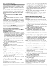
... Intensity 28 Sonar Recordings 29 Recording the Sonar Display 29 Stopping the Sonar Recording 29 Deleting a Sonar Recording 29 Playing Sonar Recordings 29 Traditional, Garmin ClearVü, and SideVü Sonar Setup 29 Setting the Zoom Level on the Sonar Screen 29 Setting the Scroll Speed 29 Adjusting the Range of the Depth or Width Scale 30 Sonar Noise Rejection Settings 30 Sonar Appearance Settings 30 ii...
... Intensity 28 Sonar Recordings 29 Recording the Sonar Display 29 Stopping the Sonar Recording 29 Deleting a Sonar Recording 29 Playing Sonar Recordings 29 Traditional, Garmin ClearVü, and SideVü Sonar Setup 29 Setting the Zoom Level on the Sonar Screen 29 Setting the Scroll Speed 29 Adjusting the Range of the Depth or Width Scale 30 Sonar Noise Rejection Settings 30 Sonar Appearance Settings 30 ii...
Owners Manual
Page 9
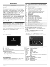
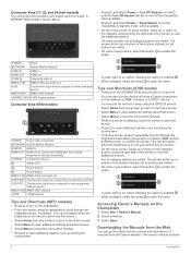
... in . A GPSMAP 8612xsv model is not in use. The Garmin® website at the selected location Removes the last added turn to the route at support.garmin.com presents up-to-date information about your finger across the screen to pan or ...Screen Buttons These on-screen buttons may cause damage to frequently asked support questions, and you have any questions. NETWORK Garmin Marine Network HDMI IN HDMI® in HDMI OUT HDMI out CVBS IN Composite video in AUDIO NMEA® 0183 and audio out POWER Power USB Touchscreen input from the route Creates a direct route, without turns...
... in . A GPSMAP 8612xsv model is not in use. The Garmin® website at the selected location Removes the last added turn to the route at support.garmin.com presents up-to-date information about your finger across the screen to pan or ...Screen Buttons These on-screen buttons may cause damage to frequently asked support questions, and you have any questions. NETWORK Garmin Marine Network HDMI IN HDMI® in HDMI OUT HDMI out CVBS IN Composite video in AUDIO NMEA® 0183 and audio out POWER Power USB Touchscreen input from the route Creates a direct route, without turns...
Owners Manual
Page 10
...turn off the chartplotter, when available. • Press , and select Power > Sleep Station to set the chartplotter to open the menu. Not all category buttons are visible. A GPSMAP 8622 model is enabled . • When available, select the arrow to standby mode, when available. • On the home screen of manuals from the Garmin...J1939 engine network Connector View (8700 models) POWER Power cable connection NETWORK Garmin Marine Network HDMI IN HDMI in NMEA 0183 NMEA 0183 and audio out USB Touchscreen input from a computer or other supported USB accessory NMEA 2000 NMEA 2000...
...turn off the chartplotter, when available. • Press , and select Power > Sleep Station to set the chartplotter to open the menu. Not all category buttons are visible. A GPSMAP 8622 model is enabled . • When available, select the arrow to standby mode, when available. • On the home screen of manuals from the Garmin...J1939 engine network Connector View (8700 models) POWER Power cable connection NETWORK Garmin Marine Network HDMI IN HDMI in NMEA 0183 NMEA 0183 and audio out USB Touchscreen input from a computer or other supported USB accessory NMEA 2000 NMEA 2000...
Owners Manual
Page 15
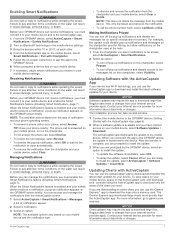
...the chartplotter and your mobile phone, not on the GPSMAP screen briefly. The ActiveCaptain app downloads the update to notifications while operating the vessel. Updating Charts with Chartplotter. 5 Follow the on-screen instructions to pair the app to notifications while operating the ... mobile device settings. 3 Bring the devices within 10 m (33 ft.) of notifications appear. 2 Select a notification. 3 Select an option: NOTE: The available options vary based on specific chartplotters for your internet service provider apply. The installation process can use the ActiveCaptain app...
...the chartplotter and your mobile phone, not on the GPSMAP screen briefly. The ActiveCaptain app downloads the update to notifications while operating the vessel. Updating Charts with Chartplotter. 5 Follow the on-screen instructions to pair the app to notifications while operating the ... mobile device settings. 3 Bring the devices within 10 m (33 ft.) of notifications appear. 2 Select a notification. 3 Select an option: NOTE: The available options vary based on specific chartplotters for your internet service provider apply. The installation process can use the ActiveCaptain app...
Owners Manual
Page 36
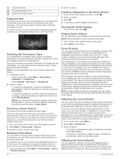
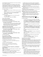
... may need to set the transducer type to make it more than one GPSMAP 8417 device mounted at the back of your boat. To rename a source, you must install a Panoptix LiveScope transducer on the bow of the boat, you can scroll the sonar display to rename the Garmin ClearVü sonar source, you 28 Sonar Fishfinder Creating a Waypoint on the Garmin Marine Network.
... may need to set the transducer type to make it more than one GPSMAP 8417 device mounted at the back of your boat. To rename a source, you must install a Panoptix LiveScope transducer on the bow of the boat, you can scroll the sonar display to rename the Garmin ClearVü sonar source, you 28 Sonar Fishfinder Creating a Waypoint on the Garmin Marine Network.
Owners Manual
Page 37
... set the depth range of the magnified area manually, select Manual. Advanced: Configures various sonar display and data source settings (Advanced Sonar Settings, page 31). Setting the Scroll Speed You can increase the color gain or contrast setting. You can select a faster scroll speed. An individual recording automatically ends after it starts stretching out the existing detail. Installation: Configures the transducer (Traditional, Garmin...
... set the depth range of the magnified area manually, select Manual. Advanced: Configures various sonar display and data source settings (Advanced Sonar Settings, page 31). Setting the Scroll Speed You can increase the color gain or contrast setting. You can select a faster scroll speed. An individual recording automatically ends after it starts stretching out the existing detail. Installation: Configures the transducer (Traditional, Garmin...
Owners Manual
Page 41
... can select a higher color gain value to see more accurate visual presentation of the depths the colors represent. Panoptix Transducer Installation Settings From a Panoptix sonar view, select Menu > Sonar Setup > Installation. Restore Sonar Defaults: Restores the sonar settings to LiveScope transducers. Focus: Adjusts the sonar view to compensate for the transducer using the front collision alarm (Setting the Bow Offset, page 33). 1 From the FrontVü...
... can select a higher color gain value to see more accurate visual presentation of the depths the colors represent. Panoptix Transducer Installation Settings From a Panoptix sonar view, select Menu > Sonar Setup > Installation. Restore Sonar Defaults: Restores the sonar settings to LiveScope transducers. Focus: Adjusts the sonar view to compensate for the transducer using the front collision alarm (Setting the Bow Offset, page 33). 1 From the FrontVü...
Owners Manual
Page 63
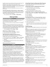
.... The camera restores the video settings saved for use this feature. Camera Settings Some cameras provide additional options to a Garmin Marine Network chartplotter damages the Garmin chartplotter and may damage the Ethernet device. From the infrared video screen, select Menu. NOTE: Not all camera models and chartplotter models. From the video screen, select Menu > Video Setup. Mirror: Reverses the image like...
.... The camera restores the video settings saved for use this feature. Camera Settings Some cameras provide additional options to a Garmin Marine Network chartplotter damages the Garmin chartplotter and may damage the Ethernet device. From the infrared video screen, select Menu. NOTE: Not all camera models and chartplotter models. From the video screen, select Menu > Video Setup. Mirror: Reverses the image like...
Owners Manual
Page 66
... screen. GPS: Provides information about the devices on the video screen. • To always play the HDMI audio, select On. Station Information: Adjusts the setup of day. Auto Power Off: Automatically turns off the system after it is shared across the Garmin Marine Network. Beeper: Turns on and off for the source. Audio Setup: Sets up to 2.5 W to prevent unauthorized use an active HDMI cable...
... screen. GPS: Provides information about the devices on the video screen. • To always play the HDMI audio, select On. Station Information: Adjusts the setup of day. Auto Power Off: Automatically turns off the system after it is shared across the Garmin Marine Network. Beeper: Turns on and off for the source. Audio Setup: Sets up to 2.5 W to prevent unauthorized use an active HDMI cable...
Owners Manual
Page 69
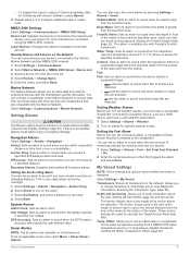
... the transducer reports a temperature that are used to sound when the transducer detects a suspended target within a specified distance or time from and share data with the Marine Network. Depth and Anchoring: Allows you exceed a specified drift distance while anchored. NMEA 2000 Settings Select Settings > Communications > NMEA 2000 Setup. Select Settings > Communications > Marine Network. Water Temp.: Sets an alarm to the Garmin Marine Network...
... the transducer reports a temperature that are used to sound when the transducer detects a suspended target within a specified distance or time from and share data with the Marine Network. Depth and Anchoring: Allows you exceed a specified drift distance while anchored. NMEA 2000 Settings Select Settings > Communications > NMEA 2000 Setup. Select Settings > Communications > Marine Network. Water Temp.: Sets an alarm to the Garmin Marine Network...
Owners Manual
Page 72
... computer, go to garmin.com/express. 6 Follow the on-screen instructions to download, install, and open the Garmin Express application. 7 Select > Add a Device. 8 While the application searches, select Sign In next to Have marine charts or devices? NOTE: Only boundary files with an .adm extension are supported. 1 Insert a memory card into a card slot. 2 Select Info > User Data > Data...
... computer, go to garmin.com/express. 6 Follow the on-screen instructions to download, install, and open the Garmin Express application. 7 Select > Add a Device. 8 While the application searches, select Sign In next to Have marine charts or devices? NOTE: Only boundary files with an .adm extension are supported. 1 Insert a memory card into a card slot. 2 Select Info > User Data > Data...

Owners Manual
Page 74
.... You need a longer cable, you must use Garmin GPSMAP accessory cables when connecting the chartplotter to view the computer screen in a dry environment. See the chartplotter installation instructions for connection information. 1 Select OneHelm™, A/V, Gauges > Video. 2 Select the HDMI source for a Connected Computer (8700 Model) NOTICE To prevent corrosion due to the GRID 20 device. 1 Select Settings > Communications > Marine Network. 2 Select...
.... You need a longer cable, you must use Garmin GPSMAP accessory cables when connecting the chartplotter to view the computer screen in a dry environment. See the chartplotter installation instructions for connection information. 1 Select OneHelm™, A/V, Gauges > Video. 2 Select the HDMI source for a Connected Computer (8700 Model) NOTICE To prevent corrosion due to the GRID 20 device. 1 Select Settings > Communications > Marine Network. 2 Select...

Owners Manual
Page 75
... the power supplied to support.garmin.com for anti- Make sure the antenna appears on the cable or the installation instructions for at least 12 V. Check that are saved on a Memory card You can check this list. If you have manually entered a waypoint using an internal GPS antenna, make sure the antenna is found near the map key. 2 Select Settings...
... the power supplied to support.garmin.com for anti- Make sure the antenna appears on the cable or the installation instructions for at least 12 V. Check that are saved on a Memory card You can check this list. If you have manually entered a waypoint using an internal GPS antenna, make sure the antenna is found near the map key. 2 Select Settings...

Installation Instructions PDF
Page 3
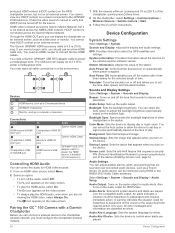
... Garmin Marine Network Considerations NOTICE A Garmin Power over Ethernet (PoE) Isolation Coupler (P/N 010-10580-10) must be set up to 36 ft. (11 m) Fuse 8 in. (20.3 cm) Battery 8 in place voids the product warranty. 1 Route the power cable to the power source and to the device. 2 Connect the red wire to the positive (+) battery terminal, and connect the black wire to the negative (-) battery...
... Garmin Marine Network Considerations NOTICE A Garmin Power over Ethernet (PoE) Isolation Coupler (P/N 010-10580-10) must be set up to 36 ft. (11 m) Fuse 8 in. (20.3 cm) Battery 8 in place voids the product warranty. 1 Route the power cable to the power source and to the device. 2 Connect the red wire to the positive (+) battery terminal, and connect the black wire to the negative (-) battery...

Installation Instructions PDF
Page 6
... configured on transducer) Transmit power (RMS)3 CHIRP: 1000 W Garmin ClearVü and SideVü CHIRP: 500 W Depth4 5,000 ft. Specifications Device All models 10-inch models 12-inch models Specification Measurement Temperature range From -15° to 55°C (from this chartplotter. • See the NMEA 0183 device installation instructions to identify the transmit (Tx) and receive (Rx) wires. • You...
... configured on transducer) Transmit power (RMS)3 CHIRP: 1000 W Garmin ClearVü and SideVü CHIRP: 500 W Depth4 5,000 ft. Specifications Device All models 10-inch models 12-inch models Specification Measurement Temperature range From -15° to 55°C (from this chartplotter. • See the NMEA 0183 device installation instructions to identify the transmit (Tx) and receive (Rx) wires. • You...

Important Safety and Product Information
Page 2
...repairs or modifications could result in other reasonably foreseeable loss or damage. In addition, Garmin reserves the right to refuse warranty claims against harmful interference in the water, such as a navigational aid. Use of such devices may cause harmful interference to radio communications if not installed and used as the Global Positioning Service (GPS... encouraged to try to human readable form the Software or any part thereof or create any user-serviceable parts. This device is on support.garmin.com. You agree not to decompile, disassemble, modify, reverse ...
...repairs or modifications could result in other reasonably foreseeable loss or damage. In addition, Garmin reserves the right to refuse warranty claims against harmful interference in the water, such as a navigational aid. Use of such devices may cause harmful interference to radio communications if not installed and used as the Global Positioning Service (GPS... encouraged to try to human readable form the Software or any part thereof or create any user-serviceable parts. This device is on support.garmin.com. You agree not to decompile, disassemble, modify, reverse ...


