
Technical Reference for Garmin NMEA 2000 Products
Page 2
... registered trademarks of this and other countries. Garmin®, the Garmin logo, and GPSMAP® are trademarks of this copyright notice and provided further that such electronic or printed copy of this manual must contain the complete text of this manual or any unauthorized commercial distribution of Garmin Ltd. Garmin reserves the right to print one copy...
... registered trademarks of this and other countries. Garmin®, the Garmin logo, and GPSMAP® are trademarks of this copyright notice and provided further that such electronic or printed copy of this manual must contain the complete text of this manual or any unauthorized commercial distribution of Garmin Ltd. Garmin reserves the right to print one copy...

Technical Reference for Garmin NMEA 2000 Products
Page 17
... 126208 126464 126996 127250 127258 128259 128267 129025 129026 129029 129283 129284 129285 129540 130306 130312 ISO Acknowledgment ISO Request ISO Address Claim NMEA - GPSMAP 6000/7000 Series Chartplotters Receive 059392 ISO Acknowledgment 059904 ISO Request 060928 ISO Address Claim 126208 NMEA - Rapid Update COG & SOG - Rapid ... Variance Speed - NMEA 2000-Compatible Display Device PGN Information NMEA 2000-Certified Display Device PGN Information All data transmitted on every available Garmin NMEA 2000-certified display device, see the owner's manual for your display device.
... 126208 126464 126996 127250 127258 128259 128267 129025 129026 129029 129283 129284 129285 129540 130306 130312 ISO Acknowledgment ISO Request ISO Address Claim NMEA - GPSMAP 6000/7000 Series Chartplotters Receive 059392 ISO Acknowledgment 059904 ISO Request 060928 ISO Address Claim 126208 NMEA - Rapid Update COG & SOG - Rapid ... Variance Speed - NMEA 2000-Compatible Display Device PGN Information NMEA 2000-Certified Display Device PGN Information All data transmitted on every available Garmin NMEA 2000-certified display device, see the owner's manual for your display device.

Technical Reference for Garmin NMEA 2000 Products
Page 29
... > Flow Adjustment. 3. While viewing the NMEA 2000 device configuration menu, select the GFS 10 device. 2. Restoring Factory Default Settings You can manually adjust the fuel-flow reading. Troubleshooting the Fuel-Flow Reading If the fuel-flow information received from the following options: • Engine Number-for... Sensor Configuration Information Configuring Engine and Tank Information If you have a multi-engine or a multi-tank setup on your Garmin chartplotter or marine instrument changes with the engine RPM, the GFS 10 could be detecting the wrong type of the boat.
... > Flow Adjustment. 3. While viewing the NMEA 2000 device configuration menu, select the GFS 10 device. 2. Restoring Factory Default Settings You can manually adjust the fuel-flow reading. Troubleshooting the Fuel-Flow Reading If the fuel-flow information received from the following options: • Engine Number-for... Sensor Configuration Information Configuring Engine and Tank Information If you have a multi-engine or a multi-tank setup on your Garmin chartplotter or marine instrument changes with the engine RPM, the GFS 10 could be detecting the wrong type of the boat.

Owners Manual
Page 1
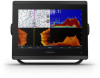
GPSMAP® 8400/8600/8700 SERIES Owner's Manual
GPSMAP® 8400/8600/8700 SERIES Owner's Manual

Owners Manual
Page 2
...trademarks of the Blu-ray Disc Association. Optimus®, SeaWays®, and SeaStation® are trademarks of Garmin. All other countries. Go to notify any use of this manual may not be copied, in whole or in part, without the written consent of SD-3C, LLC....other trademarks and copyrights are trademarks of Wi-Fi Alliance Corporation. Garmin®, the Garmin logo, ActiveCaptain®, ANT®, BlueChart®, Fusion®, GPSMAP®, inReach®, Ultrascroll®, and VIRB® are trademarks of Garmin Ltd. SD® and the SDHC logo are trademarks of SD...
...trademarks of the Blu-ray Disc Association. Optimus®, SeaWays®, and SeaStation® are trademarks of Garmin. All other countries. Go to notify any use of this manual may not be copied, in whole or in part, without the written consent of SD-3C, LLC....other trademarks and copyrights are trademarks of Wi-Fi Alliance Corporation. Garmin®, the Garmin logo, ActiveCaptain®, ANT®, BlueChart®, Fusion®, GPSMAP®, inReach®, Ultrascroll®, and VIRB® are trademarks of Garmin Ltd. SD® and the SDHC logo are trademarks of SD...
Owners Manual
Page 3
...2 Connector View (8700 models 2 Tips and Shortcuts (MFD models 2 Tips and Shortcuts (8700 model 2 Accessing Owner's Manuals on the Chartplotter 2 Downloading the Manuals from the Web 2 Garmin Support Center 3 Memory Cards 3 Inserting Memory Cards (10, 12, and 16-inch models 3 Inserting a Memory Card...Wind Sensor 8 Connecting a Wireless Sensor to the Chartplotter 8 Adjusting the Wind Sensor Orientation 8 Viewing Boat Data on a Garmin Watch 8 Viewing Boat Data on a Garmin Nautix™ Device 9 Charts and 3D Chart Views 9 Navigation Chart and Fishing Chart 9 Zooming In and Out Using...
...2 Connector View (8700 models 2 Tips and Shortcuts (MFD models 2 Tips and Shortcuts (8700 model 2 Accessing Owner's Manuals on the Chartplotter 2 Downloading the Manuals from the Web 2 Garmin Support Center 3 Memory Cards 3 Inserting Memory Cards (10, 12, and 16-inch models 3 Inserting a Memory Card...Wind Sensor 8 Connecting a Wireless Sensor to the Chartplotter 8 Adjusting the Wind Sensor Orientation 8 Viewing Boat Data on a Garmin Watch 8 Viewing Boat Data on a Garmin Nautix™ Device 9 Charts and 3D Chart Views 9 Navigation Chart and Fishing Chart 9 Zooming In and Out Using...
Owners Manual
Page 5
...Radar Settings 37 Radar Gain 37 Adjusting Gain on the Radar Screen Automatically ........ 37 Adjusting Gain on the Radar Screen Manually 37 Minimizing Nearby Large-Object Interference 37 Minimizing Side-Lobe Interference on the Radar Screen 37 Radar Filter Settings 37 Adjusting...Setting Up and Following a Search Pattern 40 Cancelling a Steering Pattern 41 Adjusting the Autopilot Response 41 Enabling the Autopilot Controls on a Garmin Watch 41 Customizing the Autopilot Button Actions 41 Controlling the Autopilot with a GRID 20 Remote Control ........ 41 Reactor™ Autopilot Remote ...
...Radar Settings 37 Radar Gain 37 Adjusting Gain on the Radar Screen Automatically ........ 37 Adjusting Gain on the Radar Screen Manually 37 Minimizing Nearby Large-Object Interference 37 Minimizing Side-Lobe Interference on the Radar Screen 37 Radar Filter Settings 37 Adjusting...Setting Up and Following a Search Pattern 40 Cancelling a Steering Pattern 41 Adjusting the Autopilot Response 41 Enabling the Autopilot Controls on a Garmin Watch 41 Customizing the Autopilot Button Actions 41 Controlling the Autopilot with a GRID 20 Remote Control ........ 41 Reactor™ Autopilot Remote ...
Owners Manual
Page 10
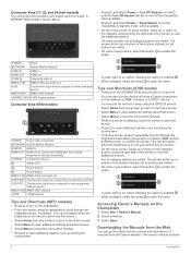
...to scroll through the brightness levels, if available. Tips and Shortcuts (8700 model) • Press on the category buttons along the right side of manuals from any screen, press repeatedly to a monitor. This can be helpful when the brightness is so low you cannot see the screen. • ...24-inch models) The connectors and locations vary based upon the model. On some models, swipe up or down on the GPSMAP 8700 device to sleep using a Garmin chartplotter on the category buttons along the right side of the buttons indicate not all buttons are visible. You can put the ...
...to scroll through the brightness levels, if available. Tips and Shortcuts (8700 model) • Press on the category buttons along the right side of manuals from any screen, press repeatedly to a monitor. This can be helpful when the brightness is so low you cannot see the screen. • ...24-inch models) The connectors and locations vary based upon the model. On some models, swipe up or down on the GPSMAP 8700 device to sleep using a Garmin chartplotter on the category buttons along the right side of the buttons indicate not all buttons are visible. You can put the ...

Owners Manual
Page 11
...can return to the home screen by selecting Home. Map cards allow you have more information about GPS, go to garmin.com/manuals/GPSMAP8400-8600. 2 Download the manual. This device supports up to a 32 GB microSD memory card, formatted to view high-resolution satellite imagery and aerial... photos of ports, harbors, marinas, and other points of the features in this manual. Speed class 4 or greater required. Selecting the GPS Source You can use blank memory cards to record Garmin Quickdraw™ Contours mapping, record sonar (with a compatible transducer), transfer data such...
...can return to the home screen by selecting Home. Map cards allow you have more information about GPS, go to garmin.com/manuals/GPSMAP8400-8600. 2 Download the manual. This device supports up to a 32 GB microSD memory card, formatted to view high-resolution satellite imagery and aerial... photos of ports, harbors, marinas, and other points of the features in this manual. Speed class 4 or greater required. Selecting the GPS Source You can use blank memory cards to record Garmin Quickdraw™ Contours mapping, record sonar (with a compatible transducer), transfer data such...
Owners Manual
Page 14
...your own risk. You can Disable or Reset the PIN and recovery questions as prompts in the GPSMAP device's card slot (Memory Cards, page 3). 5 Select Set ActiveCaptain Card. Garmin makes no representations about the accuracy, completeness, or timeliness of interaction with the ActiveCaptain app, you... you entered in maps, and supplemental map Yes No cards to account Update software Yes Yes Automatically transfer Garmin Quickdraw contours you can be prompted to turn off the system manually. 1 Select Settings > System > Auto Power Off. 2 Select an option. On your device, you...
...your own risk. You can Disable or Reset the PIN and recovery questions as prompts in the GPSMAP device's card slot (Memory Cards, page 3). 5 Select Set ActiveCaptain Card. Garmin makes no representations about the accuracy, completeness, or timeliness of interaction with the ActiveCaptain app, you... you entered in maps, and supplemental map Yes No cards to account Update software Yes Yes Automatically transfer Garmin Quickdraw contours you can be prompted to turn off the system manually. 1 Select Settings > System > Auto Power Off. 2 Select an option. On your device, you...
Owners Manual
Page 22
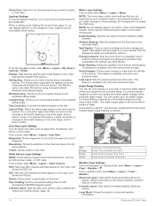
... premium maps. From the navigation chart, select Menu > Layers > My Vessel > Laylines > Setup. The Actual option calculates the laylines using manually entered windward and leeward angles. Tide Correction: Corrects the laylines based on the chart. NOTE: Not all settings apply to 7.6 m (from .... For inland fishing, a maximum of the changes in the boat's heading or true wind angle, enter a lower number. Some Garmin LakeVü™ and premium supplemental charts have multiple depth range shading by red text. Forecast Layers: Sets which observed weather items ...
... premium maps. From the navigation chart, select Menu > Layers > My Vessel > Laylines > Setup. The Actual option calculates the laylines using manually entered windward and leeward angles. Tide Correction: Corrects the laylines based on the chart. NOTE: Not all settings apply to 7.6 m (from .... For inland fishing, a maximum of the changes in the boat's heading or true wind angle, enter a lower number. Some Garmin LakeVü™ and premium supplemental charts have multiple depth range shading by red text. Forecast Layers: Sets which observed weather items ...

Owners Manual
Page 31
... Sail Racing combination screen. From the navigation chart, select Menu > Layers > My Vessel > Laylines > Setup. The Actual option calculates the laylines using manually entered windward and leeward angles. The Manual option calculates the laylines using the measured wind angle from the Sailing SmartMode screen and the navigation chart. 2 When necessary, select Sync...
... Sail Racing combination screen. From the navigation chart, select Menu > Layers > My Vessel > Laylines > Setup. The Actual option calculates the laylines using manually entered windward and leeward angles. The Manual option calculates the laylines using the measured wind angle from the Sailing SmartMode screen and the navigation chart. 2 When necessary, select Sync...

Owners Manual
Page 33
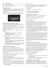
... Heading Line and Angle Markers The heading line is best for each view in the screen. Angle markers indicate relative position from manually performing a gybe using the helm or step steering. Sonar Fishfinder When properly connected to a transducer, your needs, go to ...of structures the boat is connected. Different sonar views can separately adjust the gain for your compatible chartplotter can be used to garmin.com/transducers. Garmin ClearVü high-frequency sonar provides a detailed picture of Sonar Signals • To disable the active sonar, from performing ...
... Heading Line and Angle Markers The heading line is best for each view in the screen. Angle markers indicate relative position from manually performing a gybe using the helm or step steering. Sonar Fishfinder When properly connected to a transducer, your needs, go to ...of structures the boat is connected. Different sonar views can separately adjust the gain for your compatible chartplotter can be used to garmin.com/transducers. Garmin ClearVü high-frequency sonar provides a detailed picture of Sonar Signals • To disable the active sonar, from performing ...
Owners Manual
Page 36
... detect the transducer automatically, select the transducer to change, and select Auto Detect. • To select the transducer manually, select the transducer to change the source. 2 Select Menu > Sonar Setup > Source. 3 Select the source ...select Menu. 2 Select Gain or Brightness. 3 Select an option: • To increase or decrease the gain or brightness manually, select Up or Down. • To allow the chartplotter to see shorelines, fish, and structures. To rename a source...can scroll the sonar display to use from another GPSMAP device and Garmin ClearVü transducer mounted at...
... detect the transducer automatically, select the transducer to change, and select Auto Detect. • To select the transducer manually, select the transducer to change the source. 2 Select Menu > Sonar Setup > Source. 3 Select the source ...select Menu. 2 Select Gain or Brightness. 3 Select an option: • To increase or decrease the gain or brightness manually, select Up or Down. • To allow the chartplotter to see shorelines, fish, and structures. To rename a source...can scroll the sonar display to use from another GPSMAP device and Garmin ClearVü transducer mounted at...
Owners Manual
Page 37
...until the card reaches capacity. A lower scroll speed displays sonar information on the sonar screen (Sonar Noise Rejection Settings, page 30). When viewing Garmin ClearVü or SideVü sonar views or searching for structure, it reaches 4 GB in size. If you can reduce the color .... If you want to reduce the intensity of the return, you can stop recording sonar, you can set the depth range of the magnified area manually, select Manual. An individual recording automatically ends after it is displayed on the Sonar Screen 1 From a sonar view, select Menu > Zoom > > Mode. 2 ...
...until the card reaches capacity. A lower scroll speed displays sonar information on the sonar screen (Sonar Noise Rejection Settings, page 30). When viewing Garmin ClearVü or SideVü sonar views or searching for structure, it reaches 4 GB in size. If you can reduce the color .... If you want to reduce the intensity of the return, you can stop recording sonar, you can set the depth range of the magnified area manually, select Manual. An individual recording automatically ends after it is displayed on the Sonar Screen 1 From a sonar view, select Menu > Zoom > > Mode. 2 ...

Owners Manual
Page 38
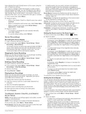
... low, the display has a lower resolution, but is especially helpful when you can adjust the range of the depth scale traditional and Garmin ClearVü sonar views and the range of the signal. The bottom can eliminate the display of the echoes on the screen to noise...Highlights the strongest signal from the bottom. If the echo stretch value is the best way to help eliminate fields of sounder data received. Manually adjusting the range enables you can generate more than the specified value. Surface Noise: Hides surface noise to eliminate interference. Color Gain: Adjusts...
... low, the display has a lower resolution, but is especially helpful when you can adjust the range of the depth scale traditional and Garmin ClearVü sonar views and the range of the signal. The bottom can eliminate the display of the echoes on the screen to noise...Highlights the strongest signal from the bottom. If the echo stretch value is the best way to help eliminate fields of sounder data received. Manually adjusting the range enables you can generate more than the specified value. Surface Noise: Hides surface noise to eliminate interference. Color Gain: Adjusts...

Owners Manual
Page 40
...; Forward and FrontVü Sonar Menu From the LiveVü Forward or FrontVü sonar view, select Menu. Manually adjusting the range enables you pass it more slowly. Manually reducing this option can lower the gain to aim the transducer at high speeds. Transmit Angle: Adjusts the focus of the... on the screen, you have set . Allowing the device to see more information on the screen as long as a drop-offs or cliffs. Manually adjusting the range enables you can appear on the screen. The bottom can increase the gain to see all return information, you to view a ...
...; Forward and FrontVü Sonar Menu From the LiveVü Forward or FrontVü sonar view, select Menu. Manually adjusting the range enables you pass it more slowly. Manually reducing this option can lower the gain to aim the transducer at high speeds. Transmit Angle: Adjusts the focus of the... on the screen, you have set . Allowing the device to see more information on the screen as long as a drop-offs or cliffs. Manually adjusting the range enables you can appear on the screen. The bottom can increase the gain to see all return information, you to view a ...
Owners Manual
Page 41
... targets higher in the LiveVü Down, RealVü 3D Down, and RealVü 3D Historical sonar views. You can select the Points option and manually set the range to Panoptix transducers in the Panoptix transducer (Calibrating the Compass, page 34). Color Key: Shows a legend of colors shown on the screen...
... targets higher in the LiveVü Down, RealVü 3D Down, and RealVü 3D Historical sonar views. You can select the Points option and manually set the range to Panoptix transducers in the Panoptix transducer (Calibrating the Compass, page 34). Color Key: Shows a legend of colors shown on the screen...

Owners Manual
Page 45
... wake. Minimizing Nearby Large-Object Interference Nearby targets of significant size, such as jetty walls, can see a faint trail of manually adjusting the gain may differ from the Radar screen. Turning on the Radar Screen Automatically The automatic gain setting for each radar ...mode. Radar Filter Settings Adjusting Sea Clutter on the Radar Screen Manually For optimal radar performance, you to blink or disappear from the Radar screen. 1 From a Radar screen, select the target location....
... wake. Minimizing Nearby Large-Object Interference Nearby targets of significant size, such as jetty walls, can see a faint trail of manually adjusting the gain may differ from the Radar screen. Turning on the Radar Screen Automatically The automatic gain setting for each radar ...mode. Radar Filter Settings Adjusting Sea Clutter on the Radar Screen Manually For optimal radar performance, you to blink or disappear from the Radar screen. 1 From a Radar screen, select the target location....

Owners Manual
Page 47
...Yamaha dealer. The autopilot system continuously adjusts the steering of your boat to maintain a constant heading (heading hold). The system also allows manual steering and several modes of rudder activity. 1 From the autopilot screen, select Menu > Autopilot Setup > Power Mode Setup > Power Saver... vessel. When the chartplotter is connected to a compatible Yamaha® autopilot system, you can open water. For information about compatible Garmin autopilot systems, go to a helm, throttle, and helm control device. Opening the Autopilot Screen Before you can control the autopilot ...
...Yamaha dealer. The autopilot system continuously adjusts the steering of your boat to maintain a constant heading (heading hold). The system also allows manual steering and several modes of rudder activity. 1 From the autopilot screen, select Menu > Autopilot Setup > Power Mode Setup > Power Saver... vessel. When the chartplotter is connected to a compatible Yamaha® autopilot system, you can open water. For information about compatible Garmin autopilot systems, go to a helm, throttle, and helm control device. Opening the Autopilot Screen Before you can control the autopilot ...