Important Safety and Product Information
Page 4
... this warranty is required. Avertissements d'installation et d'utilisation • Lors de l'installation de l'appareil dans un véhicule, placez- Garmin makes no warranty as a travel aid and must be THE WARRANTIES AND REMEDIES CONTAINED HEREIN ARE EXCLUSIVE AND IN LIEU OF ALL OTHER ... tracking number clearly on the country. Devices purchased in the United States or Canada must not be used only as to the accuracy or verification. N'installez pas l'appareil la zone de déploiement airbag. the right to refuse warranty claims against products...
... this warranty is required. Avertissements d'installation et d'utilisation • Lors de l'installation de l'appareil dans un véhicule, placez- Garmin makes no warranty as a travel aid and must be THE WARRANTIES AND REMEDIES CONTAINED HEREIN ARE EXCLUSIVE AND IN LIEU OF ALL OTHER ... tracking number clearly on the country. Devices purchased in the United States or Canada must not be used only as to the accuracy or verification. N'installez pas l'appareil la zone de déploiement airbag. the right to refuse warranty claims against products...
Owner's Manual
Page 25
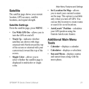
GPSMAP 78 Series Owner's Manual 21 Additional Main Menu Tools • Calendar-displays a calendar. • Calculator-displays a calculator. • Sun and Moon-displays sunrise and sunset times along with your current location, GPS accuracy, satellite locations, and signal strength. This option is displayed in multicolor or ...on and off GPS. Main Menu Features and Settings • Set Location On Map-allows you to mark your GPS position using the Garmin AutoLocate feature. Satellite Settings From the satellite page, press menu. • Use With GPS On-allows you to turn off . ...
GPSMAP 78 Series Owner's Manual 21 Additional Main Menu Tools • Calendar-displays a calendar. • Calculator-displays a calculator. • Sun and Moon-displays sunrise and sunset times along with your current location, GPS accuracy, satellite locations, and signal strength. This option is displayed in multicolor or ...on and off GPS. Main Menu Features and Settings • Set Location On Map-allows you to mark your GPS position using the Garmin AutoLocate feature. Satellite Settings From the satellite page, press menu. • Use With GPS On-allows you to turn off . ...
Owner's Manual
Page 27
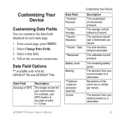
... location to a destination. GPSMAP 78 Series Owner's Manual 23 Follow the on each main page. 1. Data Field **Ambient Pressure **Ascent Average **Ascent Maximum **Ascent - The total elevation distance ascended. From a main page, press meNu. 2. Data Field Accuracy of GPS Description The margin... location to a destination. The remaining battery power. Select a data field. 4. Data Field Options ** Available only with the GPSMAP 78S and GPSMAP 78Sc. For example, your exact location. The average vertical distance of error for your GPS location is accurate to within +/- ...
... location to a destination. GPSMAP 78 Series Owner's Manual 23 Follow the on each main page. 1. Data Field **Ambient Pressure **Ascent Average **Ascent Maximum **Ascent - The total elevation distance ascended. From a main page, press meNu. 2. Data Field Accuracy of GPS Description The margin... location to a destination. The remaining battery power. Select a data field. 4. Data Field Options ** Available only with the GPSMAP 78S and GPSMAP 78Sc. For example, your exact location. The average vertical distance of error for your GPS location is accurate to within +/- ...
Owner's Manual
Page 37
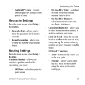
...transportation method in order to drive. ◦◦ On Road For Distance- Routing Settings From the main menu, select Setup > Routing. GPSMAP 78 Series Owner's Manual 33 Geocache Settings From the main menu, select Setup > Geocaches. • Geocache List-allows you to show the ...records ambient pressure changes over a period of geocaches found. Guidance Method-allows you to select a guidance method for variances in map position accuracy (requires routable maps). • Off Road Transitions ◦◦ Auto-automatically routes you to the next point. ◦◦ Manual...
...transportation method in order to drive. ◦◦ On Road For Distance- Routing Settings From the main menu, select Setup > Routing. GPSMAP 78 Series Owner's Manual 33 Geocache Settings From the main menu, select Setup > Geocaches. • Geocache List-allows you to show the ...records ambient pressure changes over a period of geocaches found. Guidance Method-allows you to select a guidance method for variances in map position accuracy (requires routable maps). • Off Road Transitions ◦◦ Auto-automatically routes you to the next point. ◦◦ Manual...
Owner's Manual
Page 41
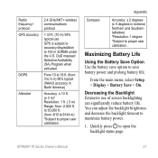
... to proper user calibration. From the main menu, select Setup > Display > Battery Save > On. GPSMAP 78 Series Owner's Manual 37 DoD imposed Selective Availability (SA) Program when activated. Decreasing the Backlight Extensive use GPS is subject to accuracy degradation to open the backlight status page. From 10 to 16 ft. (from -610 to...
... to proper user calibration. From the main menu, select Setup > Display > Battery Save > On. GPSMAP 78 Series Owner's Manual 37 DoD imposed Selective Availability (SA) Program when activated. Decreasing the Backlight Extensive use GPS is subject to accuracy degradation to open the backlight status page. From 10 to 16 ft. (from -610 to...

Owner's Manual
Page 25
... in multicolor or single color. GPSMAP 78 Series Owner's Manual 21 You can use this location to create routes or search for saved locations. • AutoLocate® Position-calculates your current location, GPS accuracy, satellite locations, and signal strength. Satellite The satellite page shows your GPS position using the Garmin AutoLocate feature. Satellite Settings...
... in multicolor or single color. GPSMAP 78 Series Owner's Manual 21 You can use this location to create routes or search for saved locations. • AutoLocate® Position-calculates your current location, GPS accuracy, satellite locations, and signal strength. Satellite The satellite page shows your GPS position using the Garmin AutoLocate feature. Satellite Settings...

Owner's Manual
Page 27
From a main page, press meNu. 2. Data Field Options ** Available only with the GPSMAP 78S and GPSMAP 78Sc. Total **Barometer Battery Level Bearing **Cadence (cadence accessory required) Course Customizing Your Device Description The uncalibrated environmental pressure... Select a data field. 4. The remaining battery power. Data Field Accuracy of GPS Description The margin of error for your current location to within +/- 12 feet. Data Field **Ambient Pressure **Ascent Average **Ascent Maximum **Ascent - GPSMAP 78 Series Owner's Manual 23 Select Change Data Fields. 3. The direction ...
From a main page, press meNu. 2. Data Field Options ** Available only with the GPSMAP 78S and GPSMAP 78Sc. Total **Barometer Battery Level Bearing **Cadence (cadence accessory required) Course Customizing Your Device Description The uncalibrated environmental pressure... Select a data field. 4. The remaining battery power. Data Field Accuracy of GPS Description The margin of error for your current location to within +/- 12 feet. Data Field **Ambient Pressure **Ascent Average **Ascent Maximum **Ascent - GPSMAP 78 Series Owner's Manual 23 Select Change Data Fields. 3. The direction ...

Owner's Manual
Page 37
... by using the point on -road routes that are shorter in distance. • Calculates Routes for-allows you to select a transportation method in map position accuracy (requires routable maps). • Off Road Transitions ◦ Auto-automatically routes you to the next point. ◦ Manual-allows you to select the next point...-road routes that require minimal time to drive. ◦ On Road For Distance- ◦ Ambient Pressure-records ambient pressure changes over a period of geocaches found. GPSMAP 78 Series Owner's Manual 33
... by using the point on -road routes that are shorter in distance. • Calculates Routes for-allows you to select a transportation method in map position accuracy (requires routable maps). • Off Road Transitions ◦ Auto-automatically routes you to the next point. ◦ Manual-allows you to select the next point...-road routes that require minimal time to drive. ◦ On Road For Distance- ◦ Ambient Pressure-records ambient pressure changes over a period of geocaches found. GPSMAP 78 Series Owner's Manual 33

Owner's Manual
Page 41
... three-axis compass is available only with the GPSMAP 78S and GPSMAP 78Sc. From 10 to 16 ft. (from 3 to 5 m) 95% typical (WAAS accuracy in North America) The barometric altimeter is available only with the GPSMAP 78S and GPSMAP 78Sc. You can significantly reduce battery life. ...DoD imposed Selective Availability (SA) Program when activated. Use the Rocker to adjust the brightness. Radio frequency/ protocol GPS accuracy DGPS Altimeter Compass 2.4 GHz/ANT+ wireless...
... three-axis compass is available only with the GPSMAP 78S and GPSMAP 78Sc. From 10 to 16 ft. (from 3 to 5 m) 95% typical (WAAS accuracy in North America) The barometric altimeter is available only with the GPSMAP 78S and GPSMAP 78Sc. You can significantly reduce battery life. ...DoD imposed Selective Availability (SA) Program when activated. Use the Rocker to adjust the brightness. Radio frequency/ protocol GPS accuracy DGPS Altimeter Compass 2.4 GHz/ANT+ wireless...


