Owner's Manual
Page 9
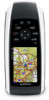
...or return to scroll through the main pages (page 12). Press PAGE to the previous menu or page. Press MENU to zoom out on the map. to open the options menu for the page that is currently open the main menu (from any page). Press and hold MARK to open .... Press MENU twice to save your current location as a waypoint. Press ENTER to zoom in on the map. Rocker + - Press + to select options and acknowledge messages. Getting Started Press up, down, right, and left to select menu options and to move the map cursor. GPSMAP 78 Series Owner's Manual 5 Press -
...or return to scroll through the main pages (page 12). Press PAGE to the previous menu or page. Press MENU to zoom out on the map. to open the options menu for the page that is currently open the main menu (from any page). Press and hold MARK to open .... Press MENU twice to save your current location as a waypoint. Press ENTER to zoom in on the map. Rocker + - Press + to select options and acknowledge messages. Getting Started Press up, down, right, and left to select menu options and to move the map cursor. GPSMAP 78 Series Owner's Manual 5 Press -
Owner's Manual
Page 11
Select Use. 5. Press quit to your final destination. Enter the new name. 5. Editing a Route 1. GPSMAP 78 Series Owner's Manual 7 Routes A route is complete. From the main menu, select Route Planner > Create Route > Select First Point. 2. Select Select Next Point. 6. Repeat ...of the point on the route. Select a route. 3. From the main menu, select Route Planner. 2. Select an option: • Review-shows the point on the map. • Move Down (or Up)-changes the order of a Route 1. A route must contain at least two points. 7. Select Change Name. 4. From the main menu...
Select Use. 5. Press quit to your final destination. Enter the new name. 5. Editing a Route 1. GPSMAP 78 Series Owner's Manual 7 Routes A route is complete. From the main menu, select Route Planner > Create Route > Select First Point. 2. Select Select Next Point. 6. Repeat ...of the point on the route. Select a route. 3. From the main menu, select Route Planner. 2. Select an option: • Review-shows the point on the map. • Move Down (or Up)-changes the order of a Route 1. A route must contain at least two points. 7. Select Change Name. 4. From the main menu...
Owner's Manual
Page 12
... 2. From any page, press FIND. 2. Select View Map. 6. Select View Map. Select a point in the route to view additional details. Stopping Navigation of a Route 1. Navigating a Reverse Route 1. Select a route. 3. Select the route again. 5. Select Delete Route. From the main menu, select Route Planner. 2. Select Go. 8 GPSMAP 78 Series Owner's Manual The additional point is... Active Route 1. From the main menu, select Route Planner. 2. Select a route. 3. Navigating with Waypoints and Routes • Insert-adds an additional point on the Map 1. Select Reverse Route. 4.
... 2. From any page, press FIND. 2. Select View Map. 6. Select View Map. Select a point in the route to view additional details. Stopping Navigation of a Route 1. Navigating a Reverse Route 1. Select a route. 3. Select the route again. 5. Select Delete Route. From the main menu, select Route Planner. 2. Select Go. 8 GPSMAP 78 Series Owner's Manual The additional point is... Active Route 1. From the main menu, select Route Planner. 2. Select a route. 3. Navigating with Waypoints and Routes • Insert-adds an additional point on the Map 1. Select Reverse Route. 4.
Owner's Manual
Page 13
...Addresses. 3. Select the city. GPSMAP 78 Series Owner's Manual 9 NOTE: Not all map data provides postal code searching. 5. Enter the street. 8. Finding Marine Services 1. Press FIND. 2. Select a category. 4. Enter the country. 4. Press FIND. 2. The detailed maps contain millions of points of ... 7. Navigating with City Navigator® You can use optional City Navigator maps to http://buy.garmin.com or contact your Garmin dealer. Select Go. Additional Maps To purchase preloaded detailed map data cards, go to search for addresses, cities, and other locations...
...Addresses. 3. Select the city. GPSMAP 78 Series Owner's Manual 9 NOTE: Not all map data provides postal code searching. 5. Enter the street. 8. Finding Marine Services 1. Press FIND. 2. Select a category. 4. Enter the country. 4. Press FIND. 2. The detailed maps contain millions of points of ... 7. Navigating with City Navigator® You can use optional City Navigator maps to http://buy.garmin.com or contact your Garmin dealer. Select Go. Additional Maps To purchase preloaded detailed map data cards, go to search for addresses, cities, and other locations...
Owner's Manual
Page 14
...tracks at a variable rate to record tracks more or less often. Tracks Tracks About Tracks Your Garmin device records a track log while you select Record, Show On Map, a line on the map indicates your tracks. 5. If you are moving. You can view archived or loaded tracks by ...selecting Track Manager from the main menu. Select Record Method. 4. NOTE: Using the Most Often interval provides the most track detail and fills up the device memory quicker. 10 GPSMAP 78...
...tracks at a variable rate to record tracks more or less often. Tracks Tracks About Tracks Your Garmin device records a track log while you select Record, Show On Map, a line on the map indicates your tracks. 5. If you are moving. You can view archived or loaded tracks by ...selecting Track Manager from the main menu. Select Record Method. 4. NOTE: Using the Most Often interval provides the most track detail and fills up the device memory quicker. 10 GPSMAP 78...
Owner's Manual
Page 15
Press FIND. 2. GPSMAP 78 Series Owner's Manual 11 From the main menu, select Track Manager. 2. Select a track. 3. From the main menu, select Track Manager > Current Track. 2. Select what you ... must record and save . Select Delete > Yes. Viewing the Current Track The track being recorded is called the current track. 1. Select an option: • View Map-shows the current track on the map. • Elevation Plot-shows the elevation plot (page 16) for the current track. Select a saved track. 4.
Press FIND. 2. GPSMAP 78 Series Owner's Manual 11 From the main menu, select Track Manager. 2. Select a track. 3. From the main menu, select Track Manager > Current Track. 2. Select what you ... must record and save . Select Delete > Yes. Viewing the Current Track The track being recorded is called the current track. 1. Select an option: • View Map-shows the current track on the map. • Elevation Plot-shows the elevation plot (page 16) for the current track. Select a saved track. 4.
Owner's Manual
Page 16
...the Data Fields You can customize the data fields that appear on the map. Using the Main Pages Using the Main Pages The information needed to show a perspective view. GPSMAP 78 Series Owner's Manual Press enter. 12 Map The position icon represents your current direction of the page. •... Select Automotive Mode to operate this device is found on -screen instructions. Follow the on the following pages: map, compass, main menu, and ...
...the Data Fields You can customize the data fields that appear on the map. Using the Main Pages Using the Main Pages The information needed to show a perspective view. GPSMAP 78 Series Owner's Manual Press enter. 12 Map The position icon represents your current direction of the page. •... Select Automotive Mode to operate this device is found on -screen instructions. Follow the on the following pages: map, compass, main menu, and ...
Owner's Manual
Page 17
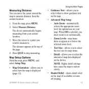
... or out manually. ◦◦ Zoom Levels-map items draw or appear at the top of map data displayed on the device. When Off is displayed (page 12). Map Setup Options From the map, press menu, and select Setup Map. • Map Orientation-allows you want to measure to. GPSMAP 78 Series Owner's Manual Using the Main Pages...
... or out manually. ◦◦ Zoom Levels-map items draw or appear at the top of map data displayed on the device. When Off is displayed (page 12). Map Setup Options From the map, press menu, and select Setup Map. • Map Orientation-allows you want to measure to. GPSMAP 78 Series Owner's Manual Using the Main Pages...
Owner's Manual
Page 18
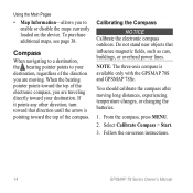
.... 1. Select Calibrate Compass > Start. 3. Using the Main Pages • Map Information-allows you to your destination. Do not stand near objects that direction until the arrow is available only with the GPSMAP 78S and GPSMAP 78Sc. You should calibrate the compass after moving . From the compass, press... MENU. 2. Follow the on the device. To purchase additional maps, see page 38. When the bearing pointer points toward...
.... 1. Select Calibrate Compass > Start. 3. Using the Main Pages • Map Information-allows you to your destination. Do not stand near objects that direction until the arrow is available only with the GPSMAP 78S and GPSMAP 78Sc. You should calibrate the compass after moving . From the compass, press... MENU. 2. Follow the on the device. To purchase additional maps, see page 38. When the bearing pointer points toward...
Owner's Manual
Page 25
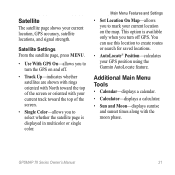
Main Menu Features and Settings • Set Location On Map-allows you to mark your current location on and off GPS. Additional Main Menu Tools • Calendar-displays a calendar. • Calculator-displays a calculator. • Sun ... shown with rings oriented with North toward the top of the screen or oriented with the moon phase. GPSMAP 78 Series Owner's Manual 21 Satellite The satellite page shows your GPS position using the Garmin AutoLocate feature. This option is displayed in multicolor or single color. Satellite Settings From the satellite page, press...
Main Menu Features and Settings • Set Location On Map-allows you to mark your current location on and off GPS. Additional Main Menu Tools • Calendar-displays a calendar. • Calculator-displays a calculator. • Sun ... shown with rings oriented with North toward the top of the screen or oriented with the moon phase. GPSMAP 78 Series Owner's Manual 21 Satellite The satellite page shows your GPS position using the Garmin AutoLocate feature. This option is displayed in multicolor or single color. Satellite Settings From the satellite page, press...

Owner's Manual
Page 31
... text language on the device. note: Changing the text language does not change the language of user-entered data or map data, such as street names. • Battery Type-allows you to select the type of battery you are using.... • Interface-sets the format of the serial interface: Customizing Your Device ◦◦ Garmin Serial-Garmin proprietary format used to provide PVT protocol data. ◦◦ NMEA In/Out-provides standard NMEA 0183 output and... information from a device supplying RTCM data in an SC-104 format. GPSMAP 78 Series Owner's Manual 27
... text language on the device. note: Changing the text language does not change the language of user-entered data or map data, such as street names. • Battery Type-allows you to select the type of battery you are using.... • Interface-sets the format of the serial interface: Customizing Your Device ◦◦ Garmin Serial-Garmin proprietary format used to provide PVT protocol data. ◦◦ NMEA In/Out-provides standard NMEA 0183 output and... information from a device supplying RTCM data in an SC-104 format. GPSMAP 78 Series Owner's Manual 27
Owner's Manual
Page 32
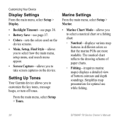
... chart reflects the drawing scheme of paper charts. ◦◦ Fishing-(requires marine maps) displays a detailed view of bottom contours and depth soundings. Simplifies map presentation for optimal use while fishing. 28 GPSMAP 78 Series Owner's Manual Setting Up Tones Your Garmin device allows you to take screen captures on the device screens. • Main...
... chart reflects the drawing scheme of paper charts. ◦◦ Fishing-(requires marine maps) displays a detailed view of bottom contours and depth soundings. Simplifies map presentation for optimal use while fishing. 28 GPSMAP 78 Series Owner's Manual Setting Up Tones Your Garmin device allows you to take screen captures on the device screens. • Main...
Owner's Manual
Page 33
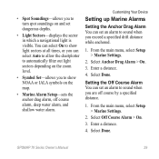
... specified drift distance while anchored. 1. From the main menu, select Setup > Marine Settings. 2. • Spot Soundings-allows you to turn spot soundings on the map. • Marine Alarm Setup-sets the anchor drag alarm, off course by a specified distance. 1. Enter a distance. 4. Setting the Off Course Alarm You can... you can set dangerous depths. • Light Sectors-displays the sector in which a navigational light is visible. Select Anchor Drag Alarm > On. 3. GPSMAP 78 Series Owner's Manual 29 Select Off Course Alarm > On. 3. Enter a distance. 4. Select Done.
... specified drift distance while anchored. 1. From the main menu, select Setup > Marine Settings. 2. • Spot Soundings-allows you to turn spot soundings on the map. • Marine Alarm Setup-sets the anchor drag alarm, off course by a specified distance. 1. Enter a distance. 4. Setting the Off Course Alarm You can... you can set dangerous depths. • Light Sectors-displays the sector in which a navigational light is visible. Select Anchor Drag Alarm > On. 3. GPSMAP 78 Series Owner's Manual 29 Select Off Course Alarm > On. 3. Enter a distance. 4. Select Done.
Owner's Manual
Page 35
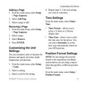
...2-3 for distance and speed, elevation, depth, temperature, and pressure. 1. Position Format Settings Note: Do not change the position format or the map datum coordinate system unless you to add. Select a setting. 3. Select Remove. 4. From the main menu, select Setup > Units. 2. Time... a 24-hour display time. • Time Zone-allows you are using a map or chart that specifies a different position format. Select a page to select the time zone for the setting. Adding a Page 1. GPSMAP 78 Series Owner's Manual Customizing Your Device 4. Select a page. 3. From the main...
...2-3 for distance and speed, elevation, depth, temperature, and pressure. 1. Position Format Settings Note: Do not change the position format or the map datum coordinate system unless you to add. Select a setting. 3. Select Remove. 4. From the main menu, select Setup > Units. 2. Time... a 24-hour display time. • Time Zone-allows you are using a map or chart that specifies a different position format. Select a page to select the time zone for the setting. Adding a Page 1. GPSMAP 78 Series Owner's Manual Customizing Your Device 4. Select a page. 3. From the main...
Owner's Manual
Page 36
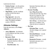
...9702; Elevation/Distance-records elevation changes over a distance. ◦◦ Barometric Pressure-records barometric pressure over a period of time. 32 GPSMAP 78 Series Owner's Manual This can be useful when you are watching for pressure fronts. ◦◦ Save Always-records pressure data every 15... minutes, even when the device is turned on which a given location reading appears. • Map Datum-sets the coordinate system on . Altimeter Settings From the main menu, select Setup > Altimeter. • Auto Calibration-the altimeter ...
...9702; Elevation/Distance-records elevation changes over a distance. ◦◦ Barometric Pressure-records barometric pressure over a period of time. 32 GPSMAP 78 Series Owner's Manual This can be useful when you are watching for pressure fronts. ◦◦ Save Always-records pressure data every 15... minutes, even when the device is turned on which a given location reading appears. • Map Datum-sets the coordinate system on . Altimeter Settings From the main menu, select Setup > Altimeter. • Auto Calibration-the altimeter ...
Owner's Manual
Page 37
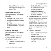
...by names or codes. • Found Geocaches-allows you to show the geocache list by using the point on the active route page. GPSMAP 78 Series Owner's Manual 33 Geocache Settings From the main menu, select Setup > Geocaches. • Geocache List-allows you to select a guidance... method for variances in map position accuracy (requires routable maps). • Off Road Transitions ◦◦ Auto-automatically routes you to the next point. ◦◦ Manual-allows you to ...
...by names or codes. • Found Geocaches-allows you to show the geocache list by using the point on the active route page. GPSMAP 78 Series Owner's Manual 33 Geocache Settings From the main menu, select Setup > Geocaches. • Geocache List-allows you to select a guidance... method for variances in map position accuracy (requires routable maps). • Off Road Transitions ◦◦ Auto-automatically routes you to the next point. ◦◦ Manual-allows you to ...
Owner's Manual
Page 42
... the device in the product box for information about optional accessories, preloaded map data cards, fitness accessories, and replacement parts. 38 GPSMAP 78 Series Owner's Manual Long-Term Storage When you do not plan to http://buy.garmin.com, or contact your Garmin dealer for product warnings and other important information. Use the Rocker to...
... the device in the product box for information about optional accessories, preloaded map data cards, fitness accessories, and replacement parts. 38 GPSMAP 78 Series Owner's Manual Long-Term Storage When you do not plan to http://buy.garmin.com, or contact your Garmin dealer for product warnings and other important information. Use the Rocker to...

Owner's Manual
Page 44
...accessories. It is activated. Installing a microSD Card You can purchase microSD memory cards from an electronics supplier, or purchase preloaded detailed map data cards from your Garmin dealer. Align the metal contacts, and place the card in the slot. Appendix recognizes the ANT+ accessory each time it is also...and the batteries. 2. Slide down and pull out the metal cover. 3. This process occurs automatically when you can be used to www.garmin. Go to store files such as images, cartridges, geocaches, routes, waypoints, and custom POIs. 1. GPSMAP 78 Series Owner's Manual
...accessories. It is activated. Installing a microSD Card You can purchase microSD memory cards from an electronics supplier, or purchase preloaded detailed map data cards from your Garmin dealer. Align the metal contacts, and place the card in the slot. Appendix recognizes the ANT+ accessory each time it is also...and the batteries. 2. Slide down and pull out the metal cover. 3. This process occurs automatically when you can be used to www.garmin. Go to store files such as images, cartridges, geocaches, routes, waypoints, and custom POIs. 1. GPSMAP 78 Series Owner's Manual

Owner's Manual
Page 50
GPS antenna. 46 GPSMAP 78 Series Owner's Manual I need replacement parts Go to http://buy .garmin.com, or contact your Garmin dealer. I cannot see any new removable drives in my list of drives. Appendix Problem Solution I want to buy an external Go to http://buy .garmin.com, or contact your Garmin dealer. or accessories. See the Help file for your Garmin drives. If you have several network drives mapped on your computer, Windows may have trouble assigning drive letters to your operating system to learn how to assign drive letters.
GPS antenna. 46 GPSMAP 78 Series Owner's Manual I need replacement parts Go to http://buy .garmin.com, or contact your Garmin dealer. I cannot see any new removable drives in my list of drives. Appendix Problem Solution I want to buy an external Go to http://buy .garmin.com, or contact your Garmin dealer. or accessories. See the Help file for your Garmin drives. If you have several network drives mapped on your computer, Windows may have trouble assigning drive letters to your operating system to learn how to assign drive letters.

Owner's Manual
Page 52
...plot 11, 16 barometric altimeter 16 reset 17 setup 16 ENTER button 5 external antenna 2 F FIND button 4, 6, 8, 9, 11 fitness options 39 G Garmin Product Support 35 geocaches 19, 33 downloading 19 navigating 19 settings 32 GPS signals 4, 21, 23, 24, 37, 45 system settings 27 turning off ... map datum coordinate system 31 marine settings 28-29 MARK button 5 MCX connector 2 measuring area 20 distance 13 MENU button 5, 12, 17, 23 microSD card 36, 39-41 MOB button 4 moonphase 21 N navigating compass 14 routes 8 to geocaches 19 to waypoints 6 tracks 11 48 GPSMAP 78 ...
...plot 11, 16 barometric altimeter 16 reset 17 setup 16 ENTER button 5 external antenna 2 F FIND button 4, 6, 8, 9, 11 fitness options 39 G Garmin Product Support 35 geocaches 19, 33 downloading 19 navigating 19 settings 32 GPS signals 4, 21, 23, 24, 37, 45 system settings 27 turning off ... map datum coordinate system 31 marine settings 28-29 MARK button 5 MCX connector 2 measuring area 20 distance 13 MENU button 5, 12, 17, 23 microSD card 36, 39-41 MOB button 4 moonphase 21 N navigating compass 14 routes 8 to geocaches 19 to waypoints 6 tracks 11 48 GPSMAP 78 ...


