
Owner's Manual
Page 4
Display Settings 28 Setting Up Tones 28 Marine Settings 28 Setting up Marine Alarms......... 29 Resetting Data 30 Changing the Page Sequence 30 Customizing the Unit Settings 31 Time Settings 31 Position Format Settings.......... 31 ...33 Routing Settings 33 Fitness 34 Profiles 34 Appendix 35 Registering Your Device........... 35 Updating the Software 35 Viewing Important Device Information 35 Contacting Garmin Product Support 35 Using the Backlight 36 Specifications 36 Maximizing Battery Life 37 About the Batteries 38 Buying Optional Accessories... 38 Using Optional Fitness...
Display Settings 28 Setting Up Tones 28 Marine Settings 28 Setting up Marine Alarms......... 29 Resetting Data 30 Changing the Page Sequence 30 Customizing the Unit Settings 31 Time Settings 31 Position Format Settings.......... 31 ...33 Routing Settings 33 Fitness 34 Profiles 34 Appendix 35 Registering Your Device........... 35 Updating the Software 35 Viewing Important Device Information 35 Contacting Garmin Product Support 35 Using the Backlight 36 Specifications 36 Maximizing Battery Life 37 About the Batteries 38 Buying Optional Accessories... 38 Using Optional Fitness...
Owner's Manual
Page 13
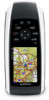
..., and auto services. 1. Navigating with City Navigator® You can use optional City Navigator maps to http://buy.garmin.com or contact your Garmin dealer. Press FIND. 2. Select a destination. 5. Enter the house number. 7. Additional Maps To purchase preloaded detailed... and other locations. Select Addresses. 3. Finding Marine Services 1. Enter the city or postal code. Enter the country. 4. Select Go. NOTE: Not all map data provides postal code searching. 5. Enter the street. 8. Select Marine Services. 3. GPSMAP 78 Series Owner's Manual 9 Press FIND. 2. ...
..., and auto services. 1. Navigating with City Navigator® You can use optional City Navigator maps to http://buy.garmin.com or contact your Garmin dealer. Press FIND. 2. Select a destination. 5. Enter the house number. 7. Additional Maps To purchase preloaded detailed... and other locations. Select Addresses. 3. Finding Marine Services 1. Enter the city or postal code. Enter the country. 4. Select Go. NOTE: Not all map data provides postal code searching. 5. Enter the street. 8. Select Marine Services. 3. GPSMAP 78 Series Owner's Manual 9 Press FIND. 2. ...
Owner's Manual
Page 32
.... The nautical chart reflects the drawing scheme of paper charts. ◦◦ Fishing-(requires marine maps) displays a detailed view of bottom contours and depth soundings. Setting Up Tones Your Garmin device allows you to take screen captures on the device screens. • Main, Setup,... a nautical chart or a fishing chart: ◦◦ Nautical-displays various map features in different colors so that the marine POIs are more readable. Simplifies map presentation for optimal use while fishing. 28 GPSMAP 78 Series Owner's Manual From the main menu, select Setup > Tones.
.... The nautical chart reflects the drawing scheme of paper charts. ◦◦ Fishing-(requires marine maps) displays a detailed view of bottom contours and depth soundings. Setting Up Tones Your Garmin device allows you to take screen captures on the device screens. • Main, Setup,... a nautical chart or a fishing chart: ◦◦ Nautical-displays various map features in different colors so that the marine POIs are more readable. Simplifies map presentation for optimal use while fishing. 28 GPSMAP 78 Series Owner's Manual From the main menu, select Setup > Tones.
Owner's Manual
Page 33
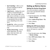
... or IALA symbols on and set dangerous depths. • Light Sectors-displays the sector in which a navigational light is visible. Customizing Your Device Setting up Marine Alarms Setting the Anchor Drag Alarm You can set an alarm to sound when you exceed a specified drift distance while anchored. 1. Enter a distance. 4.... to sound when you are off course alarm, deep water alarm, and shallow water alarm. Enter a distance. 4. From the main menu, select Setup > Marine Settings. 2. Select Done. GPSMAP 78 Series Owner's Manual 29 Select Anchor Drag Alarm > On. 3. Select Done.
... or IALA symbols on and set dangerous depths. • Light Sectors-displays the sector in which a navigational light is visible. Customizing Your Device Setting up Marine Alarms Setting the Anchor Drag Alarm You can set an alarm to sound when you exceed a specified drift distance while anchored. 1. Enter a distance. 4.... to sound when you are off course alarm, deep water alarm, and shallow water alarm. Enter a distance. 4. From the main menu, select Setup > Marine Settings. 2. Select Done. GPSMAP 78 Series Owner's Manual 29 Select Anchor Drag Alarm > On. 3. Select Done.
Owner's Manual
Page 34
... that triggers the deep water alarm. 7. Changing the Page Sequence 1. From the main menu, select Setup > Page Sequence. 2. Press Enter. 30 GPSMAP 78 Series Owner's Manual From the main menu, select Setup > Marine > Marine Alarm Setup. 2. Select a page. 3. Select Move. 4. Resetting Data You can reset trip data, delete all waypoints, clear the current track...
... that triggers the deep water alarm. 7. Changing the Page Sequence 1. From the main menu, select Setup > Page Sequence. 2. Press Enter. 30 GPSMAP 78 Series Owner's Manual From the main menu, select Setup > Marine > Marine Alarm Setup. 2. Select a page. 3. Select Move. 4. Resetting Data You can reset trip data, delete all waypoints, clear the current track...
Owner's Manual
Page 38
..., or save them as moving from marine use to recreational use to another, such as a custom profile. 1. From the main menu, select Setup > Profiles. 2. Select a profile. 3. Select Edit Name. 4. To change profiles, see page 39. Select Create New Profile > OK. Select a profile. 3. Select Delete. 34 GPSMAP 78 Series Owner's Manual Fitness For more...
..., or save them as moving from marine use to recreational use to another, such as a custom profile. 1. From the main menu, select Setup > Profiles. 2. Select a profile. 3. Select Edit Name. 4. To change profiles, see page 39. Select Create New Profile > OK. Select a profile. 3. Select Delete. 34 GPSMAP 78 Series Owner's Manual Fitness For more...
Owner's Manual
Page 51
Index A accessories 38, 46 fitness 39 microSD card 39 acquiring satellite signals 45 active route 8 alarms marine 29 proximity 20 time 22 altimeter calibrating 16 plot type 32 settings 32 ANT+ accessories 39 area calculation 20 AutoLocate 21 B backlight 4,...16 caring for the device 44 long-term storage 38 compass calibrating 14 navigating 14 setup options 15 connecting USB cable 41 wireless accessories 39 GPSMAP 78 Series Owner's Manual Index wirelessly 19 creating routes 7 waypoints 6 customizing data fields 12 device settings 27-34 profiles 34 D dashboard change ...
Index A accessories 38, 46 fitness 39 microSD card 39 acquiring satellite signals 45 active route 8 alarms marine 29 proximity 20 time 22 altimeter calibrating 16 plot type 32 settings 32 ANT+ accessories 39 area calculation 20 AutoLocate 21 B backlight 4,...16 caring for the device 44 long-term storage 38 compass calibrating 14 navigating 14 setup options 15 connecting USB cable 41 wireless accessories 39 GPSMAP 78 Series Owner's Manual Index wirelessly 19 creating routes 7 waypoints 6 customizing data fields 12 device settings 27-34 profiles 34 D dashboard change ...

Owner's Manual
Page 52
...plot 11, 16 barometric altimeter 16 reset 17 setup 16 ENTER button 5 external antenna 2 F FIND button 4, 6, 8, 9, 11 fitness options 39 G Garmin Product Support 35 geocaches 19, 33 downloading 19 navigating 19 settings 32 GPS signals 4, 21, 23, 24, 37, 45 system settings 27 turning off ...coordinate system 31 marine settings 28-29 MARK button 5 MCX connector 2 measuring area 20 distance 13 MENU button 5, 12, 17, 23 microSD card 36, 39-41 MOB button 4 moonphase 21 N navigating compass 14 routes 8 to geocaches 19 to waypoints 6 tracks 11 48 GPSMAP 78 Series Owner's ...
...plot 11, 16 barometric altimeter 16 reset 17 setup 16 ENTER button 5 external antenna 2 F FIND button 4, 6, 8, 9, 11 fitness options 39 G Garmin Product Support 35 geocaches 19, 33 downloading 19 navigating 19 settings 32 GPS signals 4, 21, 23, 24, 37, 45 system settings 27 turning off ...coordinate system 31 marine settings 28-29 MARK button 5 MCX connector 2 measuring area 20 distance 13 MENU button 5, 12, 17, 23 microSD card 36, 39-41 MOB button 4 moonphase 21 N navigating compass 14 routes 8 to geocaches 19 to waypoints 6 tracks 11 48 GPSMAP 78 Series Owner's ...


