?Important Safety and Product Information
Page 2
...that may cause undesired operation of Garmin and/or its third-party providers. It does not relieve you from the responsibility of the FCC Rules. Use caution near hazards in the water, such as the proof of the sales receipt from the GPS device. • Consult the dealer.... You agree not to export or re-export the Software to replace, the use the software embedded in this device under the Garmin Marine Warranty Policy. This warranty does not apply to use of governmental and private data sources. THE WARRANTIES AND REMEDIES CONTAINED HEREIN ARE ...
...that may cause undesired operation of Garmin and/or its third-party providers. It does not relieve you from the responsibility of the FCC Rules. Use caution near hazards in the water, such as the proof of the sales receipt from the GPS device. • Consult the dealer.... You agree not to export or re-export the Software to replace, the use the software embedded in this device under the Garmin Marine Warranty Policy. This warranty does not apply to use of governmental and private data sources. THE WARRANTIES AND REMEDIES CONTAINED HEREIN ARE ...
Owner s Manual
Page 3
...1 Getting More Information 1 Inserting Memory Cards 1 Software Update 2 Loading the New Software on a Memory Card 2 Updating the Device Software 2 GPS Satellite Signals 2 Selecting the GPS Source 2 Customizing the Chartplotter 2 Home Screen 2 Adding an Item to Favorites 2 Customizing the Layout of a SmartMode or Combination Page 2 Adding...to a Boundary 14 Editing a Boundary 14 Setting a Boundary Alarm 14 Deleting a Boundary 14 Synchronizing User Data Across the Garmin Marine Network 15 Deleting All Saved Waypoints, Routes, and Tracks 15 Sailing Features 15 Table of Contents i
...1 Getting More Information 1 Inserting Memory Cards 1 Software Update 2 Loading the New Software on a Memory Card 2 Updating the Device Software 2 GPS Satellite Signals 2 Selecting the GPS Source 2 Customizing the Chartplotter 2 Home Screen 2 Adding an Item to Favorites 2 Customizing the Layout of a SmartMode or Combination Page 2 Adding...to a Boundary 14 Editing a Boundary 14 Setting a Boundary Alarm 14 Deleting a Boundary 14 Synchronizing User Data Across the Garmin Marine Network 15 Deleting All Saved Waypoints, Routes, and Tracks 15 Sailing Features 15 Table of Contents i
Owner s Manual
Page 8
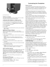
... door. Updating the Device Software Before you can select your chartplotter. Selecting the GPS Source You can update the software, you change appears only on the computer. 2 Go to www.garmin.com/support/software/marine.html. 3 Select Download next to GPSMAP Series with SD Card. 4 Read and agree to maintain a consistent appearance. You can...
... door. Updating the Device Software Before you can select your chartplotter. Selecting the GPS Source You can update the software, you change appears only on the computer. 2 Go to www.garmin.com/support/software/marine.html. 3 Select Download next to GPSMAP Series with SD Card. 4 Read and agree to maintain a consistent appearance. You can...
Owner s Manual
Page 11
...Line. 2 If necessary, select Source, and select an option: • To automatically use the source available, select Auto. • To use the GPS antenna heading for a tide station to your destination. Setting the Heading and Course Over Ground Lines You can view details about Navaids From the Navigation..., and chart data to determine the best course to help you to all charts. Angle markers can add angle markers to detailed marine charting, premium charts may be helpful for casting or finding reference points. This chart works well for minimum safe water depth and minimum...
...Line. 2 If necessary, select Source, and select an option: • To automatically use the source available, select Auto. • To use the GPS antenna heading for a tide station to your destination. Setting the Heading and Course Over Ground Lines You can view details about Navaids From the Navigation..., and chart data to determine the best course to help you to all charts. Angle markers can add angle markers to detailed marine charting, premium charts may be helpful for casting or finding reference points. This chart works well for minimum safe water depth and minimum...

Owner s Manual
Page 21
..., track, or route on one -minute intervals as you sail past the start time. 1 From a navigation chart, select Sailing > Start Line > GPS Bow Offset. 2 Enter the distance. 3 Select Done. The predictor line extends from your current location toward the start line on time. When the end... > Target Speed, and select your target speed when crossing the starting line. 3 Select Target Time, and select the target time to the Garmin Marine Network (Ethernet) automatically. When the end point is white. Using the Starting Line Guidance You can share waypoints, tracks, and routes with the...
..., track, or route on one -minute intervals as you sail past the start time. 1 From a navigation chart, select Sailing > Start Line > GPS Bow Offset. 2 Enter the distance. 3 Select Done. The predictor line extends from your current location toward the start line on time. When the end... > Target Speed, and select your target speed when crossing the starting line. 3 Select Target Time, and select the target time to the Garmin Marine Network (Ethernet) automatically. When the end point is white. Using the Starting Line Guidance You can share waypoints, tracks, and routes with the...

Owner s Manual
Page 31
...angle of the EBL, which moves the intersection point of the antenna when stopped, and select Back. The no-transmit zone is not available on GPS tracking data. Stopping the Transmission of the VRM and the EBL. On the Radar screen, the VRM appears as a circle that appears. The range... Position. 2 Use the slider bar to adjust the position of the VRM and the EBL. Radar Overlay When you connect your chartplotter to an optional Garmin marine radar, you can indicate an area within which AIS vessels appear, select Display Range, and select a distance. • To show details about AIS-...
...angle of the EBL, which moves the intersection point of the antenna when stopped, and select Back. The no-transmit zone is not available on GPS tracking data. Stopping the Transmission of the VRM and the EBL. On the Radar screen, the VRM appears as a circle that appears. The range... Position. 2 Use the slider bar to adjust the position of the VRM and the EBL. Radar Overlay When you connect your chartplotter to an optional Garmin marine radar, you can indicate an area within which AIS vessels appear, select Display Range, and select a distance. • To show details about AIS-...

Owner s Manual
Page 47
... detected. • sets the alarm to enable or disable additional output sentences. Garmin Marine Network The Garmin Marine Network allows you must be connected to external NMEA 0183 devices, a computer, or other Garmin Marine Network-compatible devices and chartplotters. Setting the Anchor Drag Alarm You can set an...right of digits to sound when the battery reaches a specified low voltage. Arrival: Sets an alarm to receive data from the bottom. GPS Accuracy: Sets an alarm to sound when the depth is 2°F (1.1°C) above or below the specified temperature. As a result...
... detected. • sets the alarm to enable or disable additional output sentences. Garmin Marine Network The Garmin Marine Network allows you must be connected to external NMEA 0183 devices, a computer, or other Garmin Marine Network-compatible devices and chartplotters. Setting the Anchor Drag Alarm You can set an...right of digits to sound when the battery reaches a specified low voltage. Arrival: Sets an alarm to receive data from the bottom. GPS Accuracy: Sets an alarm to sound when the depth is 2°F (1.1°C) above or below the specified temperature. As a result...
Owner s Manual
Page 53
...9 fishing chart 4, 37 boundary line 8 setup 8 fuel capacity 31, 42 fuel gauges 30, 31 status alarm 31, 41 synchronizing with actual fuel 31 G Garmin Marine Network 15, 41 Garmin product support, contact information 1 gauges 30 engine 30, 31 fuel 30, 31 limits 30 status alarms 31 trip 32 wind 31 Go To 11...course 41 shallow water 22, 41 sonar 22, 41 water temperature 22, 41 weather 41 anchor 41 anchor drag alarm 41 animated currents, tides 6 antenna, GPS 2 arrival alarm 41 Auto Guidance 9, 12, 40 line 13, 40 paths 12 shoreline distance 13, 40 autopilot 27, 28 adjusting the heading 28 circles ...
...9 fishing chart 4, 37 boundary line 8 setup 8 fuel capacity 31, 42 fuel gauges 30, 31 status alarm 31, 41 synchronizing with actual fuel 31 G Garmin Marine Network 15, 41 Garmin product support, contact information 1 gauges 30 engine 30, 31 fuel 30, 31 limits 30 status alarms 31 trip 32 wind 31 Go To 11...course 41 shallow water 22, 41 sonar 22, 41 water temperature 22, 41 weather 41 anchor 41 anchor drag alarm 41 animated currents, tides 6 antenna, GPS 2 arrival alarm 41 Auto Guidance 9, 12, 40 line 13, 40 paths 12 shoreline distance 13, 40 autopilot 27, 28 adjusting the heading 28 circles ...

Installation Instructions
Page 4
...with NMEA 2000, you must be connected to share data with a lamp, a horn, or both, to your Garmin dealer. • The NETWORK ports on the boat connected by a Garmin Marine Network cable. Item Description Power source À Power cable Á Horn  Lamp à Relay (100... boat, it to identify the transmitting (Tx) and receiving (Rx) A (+) and B (-) wires. When 4 Item Description NMEA 2000 compatible Garmin device GPS antenna Ignition or in -line switch. NMEA 0183 Connection Diagram + - If you are installing a NMEA 2000 power cable, you should already be...
...with NMEA 2000, you must be connected to share data with a lamp, a horn, or both, to your Garmin dealer. • The NETWORK ports on the boat connected by a Garmin Marine Network cable. Item Description Power source À Power cable Á Horn  Lamp à Relay (100... boat, it to identify the transmitting (Tx) and receiving (Rx) A (+) and B (-) wires. When 4 Item Description NMEA 2000 compatible Garmin device GPS antenna Ignition or in -line switch. NMEA 0183 Connection Diagram + - If you are installing a NMEA 2000 power cable, you should already be...