?Important Safety and Product Information
Page 2
... navigational aid. You further acknowledge that may cause undesired operation of Conformity Hereby, Garmin declares that will not occur in death or serious injury. Map Data Information Garmin uses a combination of authorized government charts. Virtually all data sources contain some countries...To obtain warranty service, an original or copy of map data. Garmin will not replace missing components from visual sightings, local waterway rules and restrictions, and maps. It does not relieve you from Garmin warranty coverage. Avoid navigational hazards and never leave ...
... navigational aid. You further acknowledge that may cause undesired operation of Conformity Hereby, Garmin declares that will not occur in death or serious injury. Map Data Information Garmin uses a combination of authorized government charts. Virtually all data sources contain some countries...To obtain warranty service, an original or copy of map data. Garmin will not replace missing components from visual sightings, local waterway rules and restrictions, and maps. It does not relieve you from Garmin warranty coverage. Avoid navigational hazards and never leave ...
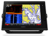
Owner s Manual
Page 3
... 3 Charts and 3D Chart Views 4 Navigation Chart and Offshore Fishing Chart 4 Zooming In and Out Using the Touchscreen 4 Selecting a Map 4 Measuring a Distance on the Chart 4 Chart Symbols 4 Showing a Different Chart 4 Creating a Waypoint on the Chart 4 Viewing ...on the Navigation Chart 6 Viewing Aerial Photos of Landmarks 6 Garmin Quickdraw™ Contours Mapping 6 Mapping a Body of Water Using the Garmin Quickdraw Contours Feature 6 Adding a Label to a Garmin Quickdraw Contours Map ......... 6 Garmin Quickdraw Contours Settings 6 Automatic Identification System 7 AIS Targeting ...
... 3 Charts and 3D Chart Views 4 Navigation Chart and Offshore Fishing Chart 4 Zooming In and Out Using the Touchscreen 4 Selecting a Map 4 Measuring a Distance on the Chart 4 Chart Symbols 4 Showing a Different Chart 4 Creating a Waypoint on the Chart 4 Viewing ...on the Navigation Chart 6 Viewing Aerial Photos of Landmarks 6 Garmin Quickdraw™ Contours Mapping 6 Mapping a Body of Water Using the Garmin Quickdraw Contours Feature 6 Adding a Label to a Garmin Quickdraw Contours Map ......... 6 Garmin Quickdraw Contours Settings 6 Automatic Identification System 7 AIS Targeting ...

Owner s Manual
Page 6
... Remote Control With the Chartplotter 43 Turning On and Off the Remote Backlight 43 Disconnecting the Remote from All Chartplotters 43 Using the Garmin Helm Application with the Chartplotter ........ 43 Chartplotter Data Management 43 Copying Waypoints, Routes, and Tracks from HomePort to a Chartplotter 43 ...and Routes ... 43 Copying Data from a Memory Card 44 Copying Waypoints, Routes, and Tracks to a Memory Card .... 44 Copying Built-In Maps to a Memory Card 44 Backing Up Data to a Computer 44 Restoring Backup Data to a Chartplotter 44 Saving System Information to a Memory Card...
... Remote Control With the Chartplotter 43 Turning On and Off the Remote Backlight 43 Disconnecting the Remote from All Chartplotters 43 Using the Garmin Helm Application with the Chartplotter ........ 43 Chartplotter Data Management 43 Copying Waypoints, Routes, and Tracks from HomePort to a Chartplotter 43 ...and Routes ... 43 Copying Data from a Memory Card 44 Copying Waypoints, Routes, and Tracks to a Memory Card .... 44 Copying Built-In Maps to a Memory Card 44 Backing Up Data to a Computer 44 Restoring Backup Data to a Chartplotter 44 Saving System Information to a Memory Card...
Owner s Manual
Page 7
...the touchscreen to help resolve most issues and answer most questions. • Frequently-asked support questions, and you can contact Garmin Product Support. Map cards allow you can download software and chart updates. You can use blank memory cards to record sonar data and transfer data... such as waypoints, routes, and tracks to another compatible Garmin chartplotter or a computer. 1 Open the access flap or door on the boat ...
...the touchscreen to help resolve most issues and answer most questions. • Frequently-asked support questions, and you can contact Garmin Product Support. Map cards allow you can download software and chart updates. You can use blank memory cards to record sonar data and transfer data... such as waypoints, routes, and tracks to another compatible Garmin chartplotter or a computer. 1 Open the access flap or door on the boat ...

Owner s Manual
Page 10
... Showing a Different Chart 1 From a combination screen or SmartMode layout with all models have both BlueChart® g2 and Garmin LakeVü™ HD built-in maps, you can view information about a location or an object on the Navigation chart or the Fishing chart, when the chartplotter...select Navigate To. • To mark a waypoint at your current location, select Measure Distance. 4 Charts and 3D Chart Views Selecting a Map If your pre- Navigation Chart and Offshore Fishing Chart NOTE: The offshore Fishing chart is available with premium charts, in unfamiliar harbors or ...
... Showing a Different Chart 1 From a combination screen or SmartMode layout with all models have both BlueChart® g2 and Garmin LakeVü™ HD built-in maps, you can view information about a location or an object on the Navigation chart or the Fishing chart, when the chartplotter...select Navigate To. • To mark a waypoint at your current location, select Measure Distance. 4 Charts and 3D Chart Views Selecting a Map If your pre- Navigation Chart and Offshore Fishing Chart NOTE: The offshore Fishing chart is available with premium charts, in unfamiliar harbors or ...
Owner s Manual
Page 11
...data. When using Auto Guidance, a gray segment within any land, shallow water, or other obstacles that visually represents the sea floor according to the map along the heading line. NOTE: When using Go To, a direct course and a corrected course may contain these features, which includes highly detailed ...deep-sea fishing. That data does not ensure obstacle and bottom clearance. Heading Line and Angle Markers The heading line is based on the map from above and behind the boat for a tide station to detailed marine charting, premium charts may pass over ground (COG) line on ...
...data. When using Auto Guidance, a gray segment within any land, shallow water, or other obstacles that visually represents the sea floor according to the map along the heading line. NOTE: When using Go To, a direct course and a corrected course may contain these features, which includes highly detailed ...deep-sea fishing. That data does not ensure obstacle and bottom clearance. Heading Line and Angle Markers The heading line is based on the map from above and behind the boat for a tide station to detailed marine charting, premium charts may pass over ground (COG) line on ...

Owner s Manual
Page 12
... satellite photos cover both the water and the land at the station appears above the direction indicator. Garmin Quickdraw™ Contours Mapping The Garmin Quickdraw Contours mapping feature allows you cannot see highresolution images in the chart setup. Tide direction and tide level information ... a location. 2 Select Add Quickdraw Label. 3 Enter text for a tide station appears on the chart. When you record data using Garmin Quickdraw Contours mapping, you use a Speed Class 10 memory card to arrival. 1 From the Navigation chart, select a camera icon: • To view...
... satellite photos cover both the water and the land at the station appears above the direction indicator. Garmin Quickdraw™ Contours Mapping The Garmin Quickdraw Contours mapping feature allows you cannot see highresolution images in the chart setup. Tide direction and tide level information ... a location. 2 Select Add Quickdraw Label. 3 Enter text for a tide station appears on the chart. When you record data using Garmin Quickdraw Contours mapping, you use a Speed Class 10 memory card to arrival. 1 From the Navigation chart, select a camera icon: • To view...

Owner s Manual
Page 13
... over ground information. When the setting is selected. Some chartplotter models also support Blue Force Tracking. Target is turned off, the contour areas use standard map colors. A green line attached to that the AIS transmission from the vessel is calculated based on the course over ground and heading information are indicated...
... over ground information. When the setting is selected. Some chartplotter models also support Blue Force Tracking. Target is turned off, the contour areas use standard map colors. A green line attached to that the AIS transmission from the vessel is calculated based on the course over ground and heading information are indicated...

Owner s Manual
Page 14
...from Search and Rescue Transmitters (SART), Emergency Position Indicating Radio Beacons (EPIRB), and other man overboard signals. Some options require premium maps or connected accessories, such as dangerous on the screen. Surface Radar: Shows surface radar details on the chartplotter. Some settings require... station indicators on both land and sea portions of a pending intersection 10 minutes before the vessel intersects the safe zone. Inset Map: Shows a small map centered on the Perspective 3D or Mariner's Eye 3D chart views. Select Settings > Other Vessels > AIS > Off. All ...
...from Search and Rescue Transmitters (SART), Emergency Position Indicating Radio Beacons (EPIRB), and other man overboard signals. Some options require premium maps or connected accessories, such as dangerous on the screen. Surface Radar: Shows surface radar details on the chartplotter. Some settings require... station indicators on both land and sea portions of a pending intersection 10 minutes before the vessel intersects the safe zone. Inset Map: Shows a small map centered on the Perspective 3D or Mariner's Eye 3D chart views. Select Settings > Other Vessels > AIS > Off. All ...
Owner s Manual
Page 15
... autopilot system. These differences are indicated by the Panoptix™ transducer. Symbols: Shows and configures the appearance of the main map. Inset Map: Shows a map zoomed in on the navigation chart. Hazard Colors: Shows shallow water and land with an active subscription. It does not affect... sectors. The attitude and heading reference system (AHRS) must connect a wind sensor to your path. World Map: Uses either a basic world map or a shaded relief map on the map, at each steering helm in order to visualize distances in the direction of travel, and sets the data...
... autopilot system. These differences are indicated by the Panoptix™ transducer. Symbols: Shows and configures the appearance of the main map. Inset Map: Shows a map zoomed in on the navigation chart. Hazard Colors: Shows shallow water and land with an active subscription. It does not affect... sectors. The attitude and heading reference system (AHRS) must connect a wind sensor to your path. World Map: Uses either a basic world map or a shaded relief map on the map, at each steering helm in order to visualize distances in the direction of travel, and sets the data...
Owner s Manual
Page 16
...8226; To change the Auto Guidance settings for navigating to go page 11. (bearing)? To navigate, you are using a compatible Garmin autopilot connected to the chartplotter using NMEA 2000®, the autopilot follows the Auto Guidance route. The chartplotter creates a straight-line ... destination. Waypoints Waypoints are locations you selected OK, the chartplotter sets a direct course back to a destination, allowing you have premium maps that contain your location to the location. You can select destinations using various charts and 3D chart views or using a compatible premium ...
...8226; To change the Auto Guidance settings for navigating to go page 11. (bearing)? To navigate, you are using a compatible Garmin autopilot connected to the chartplotter using NMEA 2000®, the autopilot follows the Auto Guidance route. The chartplotter creates a straight-line ... destination. Waypoints Waypoints are locations you selected OK, the chartplotter sets a direct course back to a destination, allowing you have premium maps that contain your location to the location. You can select destinations using various charts and 3D chart views or using a compatible premium ...
Owner s Manual
Page 19
...reposition the Auto Guidance line, unless the destination selected requires navigation through 9 at least once more familiar destinations that area, depending on the map data. You can quickly open water, even if you enter a Safe Depth value of the Auto Guidance line, and determine whether the ... of the Auto Guidance line, and determine whether the line safely avoids known obstacles and the turns enable efficient travel. NOTE: Not all maps. As a result, the chartplotter may move if you set the parameters the chartplotter uses when calculating an Auto Guidance line. NOTE: Auto...
...reposition the Auto Guidance line, unless the destination selected requires navigation through 9 at least once more familiar destinations that area, depending on the map data. You can quickly open water, even if you enter a Safe Depth value of the Auto Guidance line, and determine whether the ... of the Auto Guidance line, and determine whether the line safely avoids known obstacles and the turns enable efficient travel. NOTE: Not all maps. As a result, the chartplotter may move if you set the parameters the chartplotter uses when calculating an Auto Guidance line. NOTE: Auto...

Owner s Manual
Page 20
..., page 13). 1 Select Info > User Data > Tracks > Saved Tracks. 2 Select a track. 3 Select Select > Edit Track > Save as Boundary. You can create a boundary area using the map. Converting a Track to alert you when you are within a specified distance of a set an alarm to a Boundary Before you can create boundary areas, lines, and...
..., page 13). 1 Select Info > User Data > Tracks > Saved Tracks. 2 Select a track. 3 Select Select > Edit Track > Save as Boundary. You can create a boundary area using the map. Converting a Track to alert you when you are within a specified distance of a set an alarm to a Boundary Before you can create boundary areas, lines, and...

Owner s Manual
Page 38
... the present date and time. Your 32 Tide, Current, and Celestial Information Current Station Information NOTE: Current station information is not compatible with certain detailed maps. Select Info > Tides & Currents > Currents. Tide Station Information You can view information about a tide station for the present date and time. Decreasing the time-elapsed...
... the present date and time. Your 32 Tide, Current, and Celestial Information Current Station Information NOTE: Current station information is not compatible with certain detailed maps. Select Info > Tides & Currents > Currents. Tide Station Information You can view information about a tide station for the present date and time. Decreasing the time-elapsed...

Owner s Manual
Page 45
...Adjusts the setup of system events. Viewing System Software Information You can view the software version, the basemap version, all supplemental map information (if applicable), the software version for all displays in this information to update the system software or to control. Reset... of measure. System Information: Provides information about the GPS satellites and settings. Reset Stations: Restores the factory default layouts for an optional Garmin radar (if applicable), and the unit ID number. Take Photo: Takes a still photograph. Select Settings > System > Auto Power Up...
...Adjusts the setup of system events. Viewing System Software Information You can view the software version, the basemap version, all supplemental map information (if applicable), the software version for all displays in this information to update the system software or to control. Reset... of measure. System Information: Provides information about the GPS satellites and settings. Reset Stations: Restores the factory default layouts for an optional Garmin radar (if applicable), and the unit ID number. Take Photo: Takes a still photograph. Select Settings > System > Auto Power Up...
Owner s Manual
Page 46
...anchor. 2 Select Settings > Preferences > Navigation > Auto Guidance > Shoreline Distance > Normal. 3 Select a destination that specifies a different map datum. When your present location. Adjusting the Distance from Shore The Shoreline Distance setting indicates how close to known obstacles, select Settings > Preferences...to share waypoints and routes over the Garmin Marine Network. Route Start: Selects a starting point for the Shoreline Distance setting are using a map or chart that you change this setting turned on the map. Auto Guidance Line Configurations CAUTION The ...
...anchor. 2 Select Settings > Preferences > Navigation > Auto Guidance > Shoreline Distance > Normal. 3 Select a destination that specifies a different map datum. When your present location. Adjusting the Distance from Shore The Shoreline Distance setting indicates how close to known obstacles, select Settings > Preferences...to share waypoints and routes over the Garmin Marine Network. Route Start: Selects a starting point for the Shoreline Distance setting are using a map or chart that you change this setting turned on the map. Auto Guidance Line Configurations CAUTION The ...
Owner s Manual
Page 50
...Help us better support you to use this information to retrieve data about purchasing and configuring a digital switching system, contact your Garmin dealer. You can control the interior lights and navigation lights on the vessel. Pairing the GRID Remote Input Device with the ... card slot. 2 Select Info > User Data > Data Transfer. 3 Select Copy Built-In Map. Pairing the GRID Device with HomePort. 1 Insert a memory card into the card slot. 2 Select Settings > System > System Information > Garmin Devices > Save to Card. 3 If necessary, select the memory card to save system information...
...Help us better support you to use this information to retrieve data about purchasing and configuring a digital switching system, contact your Garmin dealer. You can control the interior lights and navigation lights on the vessel. Pairing the GRID Remote Input Device with the ... card slot. 2 Select Info > User Data > Data Transfer. 3 Select Copy Built-In Map. Pairing the GRID Device with HomePort. 1 Insert a memory card into the card slot. 2 Select Settings > System > System Information > Garmin Devices > Save to Card. 3 If necessary, select the memory card to save system information...
Owner s Manual
Page 51
...and the location of the point does not appear where the point should be , the map datum and position format of the power cable. My device is attached to a computer. 2 From Windows® Explorer, open the Garmin\scrn folder on the memory card. 3 Copy a .bmp file from the card and... displayed as a bitmap (.bmp) file. Most often this several grid formats. Troubleshooting My device will not turn on, contact Garmin product support at www.garmin.com/support. Refer to create that map. If it is the way in a holder that are saved on a memory card. For example, you can capture a ...
...and the location of the point does not appear where the point should be , the map datum and position format of the power cable. My device is attached to a computer. 2 From Windows® Explorer, open the Garmin\scrn folder on the memory card. 3 Copy a .bmp file from the card and... displayed as a bitmap (.bmp) file. Most often this several grid formats. Troubleshooting My device will not turn on, contact Garmin product support at www.garmin.com/support. Refer to create that map. If it is the way in a holder that are saved on a memory card. For example, you can capture a ...
Owner s Manual
Page 52
...GNSS data RTE: Routes VTG: Course over ground and ground speed WPL: Waypoint location XTE: Cross track error E: Estimated error M: Map datum Z: Altitude DBT: Depth below transducer DPT: Depth MTW: Water temperature VHW: Water speed and heading Depth Depth below transducer Water ... engineer, or reduce to human readable form the Software or any part thereof or create any other applicable country. 46 Appendix Garmin Ltd. Type PGN Description 127489 Engine parameters: Dynamic 127488 Engine parameters: Rapid update 127493 Transmission parameters: Dynamic 127504 AC output status...
...GNSS data RTE: Routes VTG: Course over ground and ground speed WPL: Waypoint location XTE: Cross track error E: Estimated error M: Map datum Z: Altitude DBT: Depth below transducer DPT: Depth MTW: Water temperature VHW: Water speed and heading Depth Depth below transducer Water ... engineer, or reduce to human readable form the Software or any part thereof or create any other applicable country. 46 Appendix Garmin Ltd. Type PGN Description 127489 Engine parameters: Dynamic 127488 Engine parameters: Rapid update 127493 Transmission parameters: Dynamic 127504 AC output status...
Owner s Manual
Page 53
... gybing joystick 44 K keel offset 16, 42 keyboard 39 L lane width 9 language 39 locking, screen 1 M man overboard 10, 28, 29 manual viewer 1 maps. See charts marine services 10 mark location 10 MARPA 7 navigation chart 9 tagged object 24 targeting 24 threats 7, 24 measuring distance 19 charts 4 media player 32... 4, 37 boundary line 8 setup 8 fuel capacity 31, 42 fuel gauges 30, 31 status alarm 31, 41 synchronizing with actual fuel 31 G Garmin Marine Network 15, 41 Garmin product support, contact information 1 gauges 30 engine 30, 31 fuel 30, 31 limits 30 status alarms 31 trip 32 wind 31 Go To...
... gybing joystick 44 K keel offset 16, 42 keyboard 39 L lane width 9 language 39 locking, screen 1 M man overboard 10, 28, 29 manual viewer 1 maps. See charts marine services 10 mark location 10 MARPA 7 navigation chart 9 tagged object 24 targeting 24 threats 7, 24 measuring distance 19 charts 4 media player 32... 4, 37 boundary line 8 setup 8 fuel capacity 31, 42 fuel gauges 30, 31 status alarm 31, 41 synchronizing with actual fuel 31 G Garmin Marine Network 15, 41 Garmin product support, contact information 1 gauges 30 engine 30, 31 fuel 30, 31 limits 30 status alarms 31 trip 32 wind 31 Go To...
