
Owner s Manual
Page 1
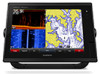
GPSMAP® 7400/7600 Series Owner's Manual February 2016 190-01841-00_0D
GPSMAP® 7400/7600 Series Owner's Manual February 2016 190-01841-00_0D

Owner s Manual
Page 2
SiriusXM® is a registered mark of their respective owners. or its subsidiaries. echoMAP™, FUSION-Link™, Garmin Helm™, Garmin LakeVü™, Garmin Quickdraw™, GCV™, GMR™, GRID™, GXM™, HomePort™, Panoptix™, Shadow ...use of Google™ Inc. Garmin®, the Garmin logo, BlueChart®, g2 Vision®, GPSMAP®, Ultrascroll®, and VIRB® are registered trademarks of FLIR Systems, Inc. Under the copyright laws, this manual without the written consent of Garmin. FLIR® is a trademark ...
SiriusXM® is a registered mark of their respective owners. or its subsidiaries. echoMAP™, FUSION-Link™, Garmin Helm™, Garmin LakeVü™, Garmin Quickdraw™, GCV™, GMR™, GRID™, GXM™, HomePort™, Panoptix™, Shadow ...use of Google™ Inc. Garmin®, the Garmin logo, BlueChart®, g2 Vision®, GPSMAP®, Ultrascroll®, and VIRB® are registered trademarks of FLIR Systems, Inc. Under the copyright laws, this manual without the written consent of Garmin. FLIR® is a trademark ...
Owner s Manual
Page 3
... Overview 1 Using the Touchscreen 1 On-Screen Buttons 1 Tips and Shortcuts 1 Locking the Touchscreen 1 Accessing Owner's Manuals on the Chartplotter 1 Downloading the Manuals 1 Getting More Information 1 Inserting Memory Cards 1 Software Update 2 Loading the New Software on a Memory... Chart 6 Viewing Aerial Photos of Landmarks 6 Garmin Quickdraw™ Contours Mapping 6 Mapping a Body of Water Using the Garmin Quickdraw Contours Feature 6 Adding a Label to a Garmin Quickdraw Contours Map ......... 6 Garmin Quickdraw Contours Settings 6 Automatic Identification System 7 ...
... Overview 1 Using the Touchscreen 1 On-Screen Buttons 1 Tips and Shortcuts 1 Locking the Touchscreen 1 Accessing Owner's Manuals on the Chartplotter 1 Downloading the Manuals 1 Getting More Information 1 Inserting Memory Cards 1 Software Update 2 Loading the New Software on a Memory... Chart 6 Viewing Aerial Photos of Landmarks 6 Garmin Quickdraw™ Contours Mapping 6 Mapping a Body of Water Using the Garmin Quickdraw Contours Feature 6 Adding a Label to a Garmin Quickdraw Contours Map ......... 6 Garmin Quickdraw Contours Settings 6 Automatic Identification System 7 ...
Owner s Manual
Page 7
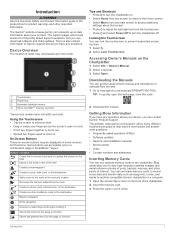
... memory card slot à *Seven-inch models have any questions about your device, you can get the latest owner's manual and translations of interest. The Garmin® website at the selected location Removes the last turn added from the route Creates a direct route, without turns...function Tips and Shortcuts • Press to zoom in a combination page or SmartMode™ layout. Accessing Owner's Manuals on some screens and functions. The website, www.garmin.com/support, offers many different troubleshooting tips to help resolve most issues and answer most questions. •...
... memory card slot à *Seven-inch models have any questions about your device, you can get the latest owner's manual and translations of interest. The Garmin® website at the selected location Removes the last turn added from the route Creates a direct route, without turns...function Tips and Shortcuts • Press to zoom in a combination page or SmartMode™ layout. Accessing Owner's Manuals on some screens and functions. The website, www.garmin.com/support, offers many different troubleshooting tips to help resolve most issues and answer most questions. •...
Owner s Manual
Page 35
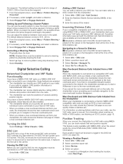
...DSC list, the chartplotter must be connected to the manoverboard point. For information about marking an MOB or SOS location, see the VHF radio owner's manual. You can quickly initiate a distress call from the active waypoint. 1 From the autopilot screen, select Menu > Pattern Steering > Cloverleaf. 2... you can track vessels that information is received from the radio, the chartplotter shows the manoverboard screen and prompts you have a Garmin NMEA 2000 VHF radio connected to your chartplotter, the radio shows the Distress Call page to a Vessel in Distress designates a ...
...DSC list, the chartplotter must be connected to the manoverboard point. For information about marking an MOB or SOS location, see the VHF radio owner's manual. You can quickly initiate a distress call from the active waypoint. 1 From the autopilot screen, select Menu > Pattern Steering > Cloverleaf. 2... you can track vessels that information is received from the radio, the chartplotter shows the manoverboard screen and prompts you have a Garmin NMEA 2000 VHF radio connected to your chartplotter, the radio shows the Distress Call page to a Vessel in Distress designates a ...
Camera Integration Guide
Page 3
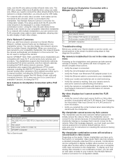
...Description Axis network camera Axis midspan PoE injector (or equivalent) PoE isolation coupler (GPN 010-10580-10) GPSMAP chartplotter Troubleshooting Before you contact your camera owner's manual for more information on camera compatibility. Axis Camera to each video stream. When this message appears, you ...You can be displayed on . • Verify the Ethernet cable is on one cable only. Garmin GPSMAP 7400, 7600, and 8000 series chartplotters are on multiple Garmin chartplotters. You can add an Axis video encoder to your Axis camera password to Chartplotter Connection with...
...Description Axis network camera Axis midspan PoE injector (or equivalent) PoE isolation coupler (GPN 010-10580-10) GPSMAP chartplotter Troubleshooting Before you contact your camera owner's manual for more information on camera compatibility. Axis Camera to each video stream. When this message appears, you ...You can be displayed on . • Verify the Ethernet cable is on one cable only. Garmin GPSMAP 7400, 7600, and 8000 series chartplotters are on multiple Garmin chartplotters. You can add an Axis video encoder to your Axis camera password to Chartplotter Connection with...