
Owner s Manual
Page 2
..., BlueChart®, g2 Vision®, GPSMAP®, Ultrascroll®, and VIRB® are trademarks of Garmin Ltd. or its subsidiaries, registered in the United States and other countries. or its products and to make changes in part, without the...written consent of Wi-Fi Alliance Corporation. SiriusXM® is a registered mark of Garmin. Wi‑Fi® is a registered trademark of Garmin. These trademarks may not be used without obligation to www.garmin.com for current updates and supplemental information concerning the use of this manual without the express permission of ...
..., BlueChart®, g2 Vision®, GPSMAP®, Ultrascroll®, and VIRB® are trademarks of Garmin Ltd. or its subsidiaries, registered in the United States and other countries. or its products and to make changes in part, without the...written consent of Wi-Fi Alliance Corporation. SiriusXM® is a registered mark of Garmin. Wi‑Fi® is a registered trademark of Garmin. These trademarks may not be used without obligation to www.garmin.com for current updates and supplemental information concerning the use of this manual without the express permission of ...
Owner s Manual
Page 3
...Manuals on the Chartplotter 1 Downloading the Manuals 1 Getting More Information 1 Inserting Memory Cards 1 Software Update 2 Loading the New Software on a Memory Card 2 Updating the Device Software 2 GPS Satellite Signals 2 Selecting the GPS Source 2 Customizing the Chartplotter 2 Home... Chart 6 Viewing Aerial Photos of Landmarks 6 Garmin Quickdraw™ Contours Mapping 6 Mapping a Body of Water Using the Garmin Quickdraw Contours Feature 6 Adding a Label to a Garmin Quickdraw Contours Map ......... 6 Garmin Quickdraw Contours Settings 6 Automatic Identification System 7 ...
...Manuals on the Chartplotter 1 Downloading the Manuals 1 Getting More Information 1 Inserting Memory Cards 1 Software Update 2 Loading the New Software on a Memory Card 2 Updating the Device Software 2 GPS Satellite Signals 2 Selecting the GPS Source 2 Customizing the Chartplotter 2 Home... Chart 6 Viewing Aerial Photos of Landmarks 6 Garmin Quickdraw™ Contours Mapping 6 Mapping a Body of Water Using the Garmin Quickdraw Contours Feature 6 Adding a Label to a Garmin Quickdraw Contours Map ......... 6 Garmin Quickdraw Contours Settings 6 Automatic Identification System 7 ...
Owner s Manual
Page 7
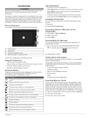
... answers to frequently asked questions (FAQs) • Software updates • Owner's and installation manuals • Service alerts • Video • Contact numbers and addresses Inserting Memory Cards You can contact Garmin Product Support. Some buttons are accessible only in the chartplotter.... Locking the Touchscreen You can download software and chart updates. TIP: To quickly open this web page, scan this code: 2 ...
... answers to frequently asked questions (FAQs) • Software updates • Owner's and installation manuals • Service alerts • Video • Contact numbers and addresses Inserting Memory Cards You can contact Garmin Product Support. Some buttons are accessible only in the chartplotter.... Locking the Touchscreen You can download software and chart updates. TIP: To quickly open this web page, scan this code: 2 ...
Owner s Manual
Page 8
.... The SmartMode items are dependant on all displays in a display you have all of the home screen are installed on the Garmin Marine Network, you must obtain a software-update memory card or load the latest software onto a memory card. 1 Turn on the left. For example, when Cruising is ... example, the Sonar category displays the views and pages related to www.garmin.com /aboutGPS. When you change how data appears on the computer. 2 Go to www.garmin.com/support/software/marine.html. 3 Select Download next to GPSMAP Series with SD Card. 4 Read and agree to the Favorites home ...
.... The SmartMode items are dependant on all displays in a display you have all of the home screen are installed on the Garmin Marine Network, you must obtain a software-update memory card or load the latest software onto a memory card. 1 Turn on the left. For example, when Cruising is ... example, the Sonar category displays the views and pages related to www.garmin.com /aboutGPS. When you change how data appears on the computer. 2 Go to www.garmin.com/support/software/marine.html. 3 Select Download next to GPSMAP Series with SD Card. 4 Read and agree to the Favorites home ...

Owner s Manual
Page 9
.... 2 Select a preset. 3 Select an option: • To rename the preset, select Rename, enter a name, and select Done. • To edit the preset, select Edit, and update the preset. • To delete the preset, select Delete. • To reset all presets to open the backlight settings. 2 Select an option: • Adjust the...
.... 2 Select a preset. 3 Select an option: • To rename the preset, select Rename, enter a name, and select Done. • To edit the preset, select Edit, and update the preset. • To delete the preset, select Delete. • To reset all presets to open the backlight settings. 2 Select an option: • Adjust the...

Owner s Manual
Page 23
... from a transducer. To receive Panoptix sonar, you need a compatible chartplotter, a compatible sounder module, and a compatible transducer. The screen updates very quickly, producing sonar views that graph, on the same screen. The screen updates with each sweep of a dual-frequency transducer. You can separately adjust the gain for each frequency. The full-screen...
... from a transducer. To receive Panoptix sonar, you need a compatible chartplotter, a compatible sounder module, and a compatible transducer. The screen updates very quickly, producing sonar views that graph, on the same screen. The screen updates with each sweep of a dual-frequency transducer. You can separately adjust the gain for each frequency. The full-screen...
Owner s Manual
Page 27
... bottom brown to remove interference from the list. If the device automatically detected your transducer, this setting to extend the length of transducer you can update how quickly the transducer sweeps back and forth. RealVü Sonar Settings From a RealVü sonar view, select Menu > Sonar Setup. Alarms: Sets sonar alarms...
... bottom brown to remove interference from the list. If the device automatically detected your transducer, this setting to extend the length of transducer you can update how quickly the transducer sweeps back and forth. RealVü Sonar Settings From a RealVü sonar view, select Menu > Sonar Setup. Alarms: Sets sonar alarms...

Owner s Manual
Page 41
...within the last seven minutes. Select Charts > Precipitation. Each line represents 15 minutes. NOTE: This feature is a region of the latest update or as weather symbols. Weather Warnings and Weather Bulletins When a marine weather warning, weather watch, weather advisory, weather bulletin, or other... applies. Precipitation is shown either weather watches or weather advisories. The time stamp indicates the elapsed time since the weather data provider last updated the information. Red cones appear with a weather chart, select Menu > Weather Menu > Change Weather. 2 Select a weather chart....
...within the last seven minutes. Select Charts > Precipitation. Each line represents 15 minutes. NOTE: This feature is a region of the latest update or as weather symbols. Weather Warnings and Weather Bulletins When a marine weather warning, weather watch, weather advisory, weather bulletin, or other... applies. Precipitation is shown either weather watches or weather advisories. The time stamp indicates the elapsed time since the weather data provider last updated the information. Red cones appear with a weather chart, select Menu > Weather Menu > Change Weather. 2 Select a weather chart....

Owner s Manual
Page 42
... optimal weather conditions for the previous 36 hours, in the legend. The chartplotter automatically finds the lower and upper limits for the current screen, and updates the temperaturecolor scale. • To enter the lower and upper limits for an area appear as pressure isobars and pressure centers. Select Charts > Visibility. Viewing...
... optimal weather conditions for the previous 36 hours, in the legend. The chartplotter automatically finds the lower and upper limits for the current screen, and updates the temperaturecolor scale. • To enter the lower and upper limits for an area appear as pressure isobars and pressure centers. Select Charts > Visibility. Viewing...
Owner s Manual
Page 43
...a weather chart, select Menu > Weather Subscription. Compatible devices include video devices connected to the ports on the chartplotter or to the Garmin Marine Network, as well as a FLIR® camera, to the alternating sequence. • To view a local weather forecast, ... compatible video device connected to the Garmin Marine Network. Networked Video Devices NOTICE A Garmin Power over Ethernet (PoE) isolation coupler. Connecting a PoE device directly to a Garmin Marine Network chartplotter damages the Garmin chartplotter and may need to update the camera software to use on ...
...a weather chart, select Menu > Weather Subscription. Compatible devices include video devices connected to the ports on the chartplotter or to the Garmin Marine Network, as well as a FLIR® camera, to the alternating sequence. • To view a local weather forecast, ... compatible video device connected to the Garmin Marine Network. Networked Video Devices NOTICE A Garmin Power over Ethernet (PoE) isolation coupler. Connecting a PoE device directly to a Garmin Marine Network chartplotter damages the Garmin chartplotter and may need to update the camera software to use on ...
Owner s Manual
Page 44
... camera may not fill the entire screen. • To show the video using gestures directly on all connected, supported video devices. You may need to update the camera software to the lens may occur. Refer to , select Video, and select a video source. 4 Repeat step 3 for one function within each ...Change Scene: Selects the infrared image mode, such as day, night, MOB, or docking. Video Setup: Opens more video options. You may need to update the camera software to conserve power and protect the lens when not in use one built-in the desired direction. From the video screen, select...
... camera may not fill the entire screen. • To show the video using gestures directly on all connected, supported video devices. You may need to update the camera software to the lens may occur. Refer to , select Video, and select a video source. 4 Repeat step 3 for one function within each ...Change Scene: Selects the infrared image mode, such as day, night, MOB, or docking. Video Setup: Opens more video options. You may need to update the camera software to conserve power and protect the lens when not in use one built-in the desired direction. From the video screen, select...

Owner s Manual
Page 45
...on the location of videos. Video Mode: Sets the video mode. Video Size: Sets the size or pixel dimensions of this information to update the system software or to enter a new name for the layouts in this station. Adding the VIRB X/XE Action Camera Controls to Other... Sets the size or pixel dimensions of the screen. System Settings Select Settings > System. Reset Stations: Restores the factory default layouts for an optional Garmin radar (if applicable), and the unit ID number. Select Settings > System > System Information. Keyboard Layout: Arranges the keys on the on the ...
...on the location of videos. Video Mode: Sets the video mode. Video Size: Sets the size or pixel dimensions of this information to update the system software or to enter a new name for the layouts in this station. Adding the VIRB X/XE Action Camera Controls to Other... Sets the size or pixel dimensions of the screen. System Settings Select Settings > System. Reset Stations: Restores the factory default layouts for an optional Garmin radar (if applicable), and the unit ID number. Select Settings > System > System Information. Keyboard Layout: Arranges the keys on the on the ...
Owner s Manual
Page 51
... device software (Software Update, page 2). • Make sure the device has a clear view of the point does not appear where the point should be a legend on the cable or the installation instructions for at www.garmin.com/support. You can check this is less than 10 V, the... Preferences > Units. 3 Select the correct map datum and position format settings. 4 Create the waypoint again. My device will not turn on , contact Garmin product support at least six seconds. For example, you want to the device. Commonly displayed as a bitmap (.bmp) file. Latitude and longitude lines on...
... device software (Software Update, page 2). • Make sure the device has a clear view of the point does not appear where the point should be a legend on the cable or the installation instructions for at www.garmin.com/support. You can check this is less than 10 V, the... Preferences > Units. 3 Select the correct map datum and position format settings. 4 Create the waypoint again. My device will not turn on , contact Garmin product support at least six seconds. For example, you want to the device. Commonly displayed as a bitmap (.bmp) file. Latitude and longitude lines on...
Owner s Manual
Page 52
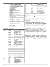
...Transmission parameters: Dynamic 127504 AC output status 127505 Fluid level 127508 Battery status 128259 Speed: Water referenced 128267 Water depth 129025 Position: Rapid update 129038 AIS class A position report 129039 AIS class B position report 129040 AIS class B extended position report 129539 GNSS DOPs 129794 AIS ... satellites GSV: GNSS satellites in violation of the export control laws of the United States of America or the export control laws of Garmin and/or its third-party providers and is protected under the United States of the product. You agree not to decompile, disassemble, ...
...Transmission parameters: Dynamic 127504 AC output status 127505 Fluid level 127508 Battery status 128259 Speed: Water referenced 128267 Water depth 129025 Position: Rapid update 129038 AIS class A position report 129039 AIS class B position report 129040 AIS class B extended position report 129539 GNSS DOPs 129794 AIS ... satellites GSV: GNSS satellites in violation of the export control laws of the United States of America or the export control laws of Garmin and/or its third-party providers and is protected under the United States of the product. You agree not to decompile, disassemble, ...
Owner s Manual
Page 54
... system information 39 Shadow Drive, enabling 28 shoreline distance 13, 40 SideVü 17 SiriusXM 34 Satellite Radio 34 SiriusXM Satellite Radio 33, 34 software updates 2 updating 2 software license agreement 46 sonar 16, 19, 22 a-scope 21, 22 alarms 22, 41 appearance 22 bottom lock 20 color gain 19 color rejection... 13 saving as route 14 showing 9, 13 transducer 16, 18, 21, 22 trip gauges 32 troubleshooting 45 U unit ID 39 units of measure 40 updates, software 2 user data deleting 15 synchronizing 15 V vessel trails 9, 30 VHF radio 29 calling an AIS target 30 distress calls 29 DSC channel 30 ...
... system information 39 Shadow Drive, enabling 28 shoreline distance 13, 40 SideVü 17 SiriusXM 34 Satellite Radio 34 SiriusXM Satellite Radio 33, 34 software updates 2 updating 2 software license agreement 46 sonar 16, 19, 22 a-scope 21, 22 alarms 22, 41 appearance 22 bottom lock 20 color gain 19 color rejection... 13 saving as route 14 showing 9, 13 transducer 16, 18, 21, 22 trip gauges 32 troubleshooting 45 U unit ID 39 units of measure 40 updates, software 2 user data deleting 15 synchronizing 15 V vessel trails 9, 30 VHF radio 29 calling an AIS target 30 distress calls 29 DSC channel 30 ...
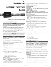
Installation Instructions
Page 1
...the device must obtain a software-update memory card or load the latest software onto a memory card. 1 Turn on the chartplotter. 2 After the home screen appears, insert the memory card into the card slot on the opposite side of the surface. GPSMAP® 7400/7600 Series Installation .... The device returns to normal operation after the software update process is on the computer. 2 Go to www.garmin.com/support/software/marine.html. 3 Select Download next to Garmin Marine Network with SD card. 4 Read and agree to http://my.garmin.com. • Keep the original sales receipt, or...
...the device must obtain a software-update memory card or load the latest software onto a memory card. 1 Turn on the chartplotter. 2 After the home screen appears, insert the memory card into the card slot on the opposite side of the surface. GPSMAP® 7400/7600 Series Installation .... The device returns to normal operation after the software update process is on the computer. 2 Go to www.garmin.com/support/software/marine.html. 3 Select Download next to Garmin Marine Network with SD card. 4 Read and agree to http://my.garmin.com. • Keep the original sales receipt, or...
Installation Instructions
Page 6
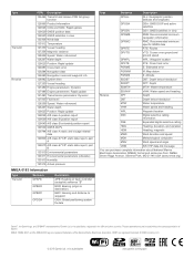
...of the National Marine Electronics Association. HDMI® is a registered trademark of Garmin. Type Transmit Receive PGN Description 126464 Transmit and receive PGN list group function 126996 Product information 129026 COG and SOG: Rapid update 129029 GNSS position data 129540 GNSS satellites in view 130306 Wind data 130312 ... National Marine Electronics Association (NMEA) format and sentences from: NMEA, Seven Riggs Avenue, Severna Park, MD 21146 USA (www.nmea.org) Garmin®, the Garmin logo, and GPSMAP® are registered trademarks of Garmin Ltd. or its subsidiaries www...
...of the National Marine Electronics Association. HDMI® is a registered trademark of Garmin. Type Transmit Receive PGN Description 126464 Transmit and receive PGN list group function 126996 Product information 129026 COG and SOG: Rapid update 129029 GNSS position data 129540 GNSS satellites in view 130306 Wind data 130312 ... National Marine Electronics Association (NMEA) format and sentences from: NMEA, Seven Riggs Avenue, Severna Park, MD 21146 USA (www.nmea.org) Garmin®, the Garmin logo, and GPSMAP® are registered trademarks of Garmin Ltd. or its subsidiaries www...
