
Owner s Manual
Page 1
GPSMAP® 7400/7600 Series Owner's Manual February 2016 190-01841-00_0D
GPSMAP® 7400/7600 Series Owner's Manual February 2016 190-01841-00_0D

Owner s Manual
Page 2
... SD-3C, LLC. Windows® is a registered trademark of SiriusXM Radio Inc. Go to www.garmin.com for current updates and supplemental information concerning the use of this manual may not be copied, in whole or in part, without the written consent of Microsoft Corporation in ...the United States and other countries. Garmin®, the Garmin logo, BlueChart®, g2 Vision®, GPSMAP®, Ultrascroll®, and VIRB® ...
... SD-3C, LLC. Windows® is a registered trademark of SiriusXM Radio Inc. Go to www.garmin.com for current updates and supplemental information concerning the use of this manual may not be copied, in whole or in part, without the written consent of Microsoft Corporation in ...the United States and other countries. Garmin®, the Garmin logo, BlueChart®, g2 Vision®, GPSMAP®, Ultrascroll®, and VIRB® ...
Owner s Manual
Page 3
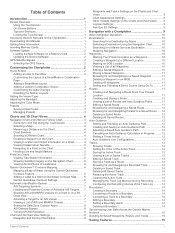
... 1 Using the Touchscreen 1 On-Screen Buttons 1 Tips and Shortcuts 1 Locking the Touchscreen 1 Accessing Owner's Manuals on the Chartplotter 1 Downloading the Manuals 1 Getting More Information 1 Inserting Memory Cards 1 Software Update 2 Loading the New Software on a Memory Card...Navigation Chart 6 Viewing Aerial Photos of Landmarks 6 Garmin Quickdraw™ Contours Mapping 6 Mapping a Body of Water Using the Garmin Quickdraw Contours Feature 6 Adding a Label to a Garmin Quickdraw Contours Map ......... 6 Garmin Quickdraw Contours Settings 6 Automatic Identification System 7 ...
... 1 Using the Touchscreen 1 On-Screen Buttons 1 Tips and Shortcuts 1 Locking the Touchscreen 1 Accessing Owner's Manuals on the Chartplotter 1 Downloading the Manuals 1 Getting More Information 1 Inserting Memory Cards 1 Software Update 2 Loading the New Software on a Memory Card...Navigation Chart 6 Viewing Aerial Photos of Landmarks 6 Garmin Quickdraw™ Contours Mapping 6 Mapping a Body of Water Using the Garmin Quickdraw Contours Feature 6 Adding a Label to a Garmin Quickdraw Contours Map ......... 6 Garmin Quickdraw Contours Settings 6 Automatic Identification System 7 ...
Owner s Manual
Page 7
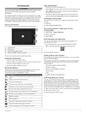
... fingers together to zoom out. • Spread two fingers apart to www.garmin.com/manuals/GPSMAP7400-7600. Introduction 1 Introduction WARNING See the Important Safety and Product Information guide in . The Garmin® website at the selected location Removes the last turn the chartplotter on ...the Chartplotter 1 Select Info > Owner's Manual. 2 Select a manual. 3 Select Open. Map cards allow you have any main screen ...
... fingers together to zoom out. • Spread two fingers apart to www.garmin.com/manuals/GPSMAP7400-7600. Introduction 1 Introduction WARNING See the Important Safety and Product Information guide in . The Garmin® website at the selected location Removes the last turn the chartplotter on ...the Chartplotter 1 Select Info > Owner's Manual. 2 Select a manual. 3 Select Open. Map cards allow you have any main screen ...
Owner s Manual
Page 8
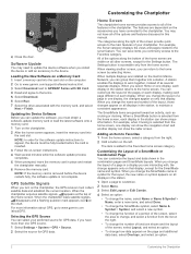
... those changes appear on all displays in a display you change appears only on the computer. 2 Go to www.garmin.com/support/software/marine.html. 3 Select Download next to GPSMAP Series with the memory card, and select Next > Finish. NOTE: If the memory card is removed before the ...Software Update You may not have connected to the sonar feature. Loading the New Software on all displays in place and restart the chartplotter manually. 6 Remove the memory card. Updating the Device Software Before you must collect satellite data and establish the current location. Home Screen The...
... those changes appear on all displays in a display you change appears only on the computer. 2 Go to www.garmin.com/support/software/marine.html. 3 Select Download next to GPSMAP Series with the memory card, and select Next > Finish. NOTE: If the memory card is removed before the ...Software Update You may not have connected to the sonar feature. Loading the New Software on all displays in place and restart the chartplotter manually. 6 Remove the memory card. Updating the Device Software Before you must collect satellite data and establish the current location. Home Screen The...
Owner s Manual
Page 15
... which is specific to all Waypoints, page 10). When in on the tide. From the navigation chart, select Menu > Sailing > Laylines. The Manual option calculates the laylines using Go To, a direct course and a corrected course may be installed at different zoom levels. Tide Correction: Corrects the ...sonar shallow water alarm setting. List: Shows a list of the map. From the Fish Eye 3D chart view, select Menu. When using manually entered windward and leeward angles. NOTE: Mariner's Eye 3D and Fish Eye 3D chart views are equal to display waypoints on track color. ...
... which is specific to all Waypoints, page 10). When in on the tide. From the navigation chart, select Menu > Sailing > Laylines. The Manual option calculates the laylines using Go To, a direct course and a corrected course may be installed at different zoom levels. Tide Correction: Corrects the ...sonar shallow water alarm setting. List: Shows a list of the map. From the Fish Eye 3D chart view, select Menu. When using manually entered windward and leeward angles. NOTE: Mariner's Eye 3D and Fish Eye 3D chart views are equal to display waypoints on track color. ...

Owner s Manual
Page 21
... navigation chart, select Menu > Sailing > Laylines. Sailing Ang.: Allows you should backup your user data to prevent possible data loss. The Manual option calculates the laylines using the measured wind angle from the Sailing SmartMode screen and the navigation chart. 2 When necessary, select Sync to ...avoid a penalty for your boat will be very helpful when racing. This indicates the boat is red. Synchronizing User Data Across the Garmin Marine Network NOTICE Before you synchronize the user data across all models. The predictor line extends from each pin. NOTE: You can...
... navigation chart, select Menu > Sailing > Laylines. Sailing Ang.: Allows you should backup your user data to prevent possible data loss. The Manual option calculates the laylines using the measured wind angle from the Sailing SmartMode screen and the navigation chart. 2 When necessary, select Sync to ...avoid a penalty for your boat will be very helpful when racing. This indicates the boat is red. Synchronizing User Data Across the Garmin Marine Network NOTICE Before you synchronize the user data across all models. The predictor line extends from each pin. NOTE: You can...
Owner s Manual
Page 22
... gybe delay allows you must connect a NMEA 2000 or NMEA 0183 wind sensor to the autopilot. Sonar When properly connected to an optional Garmin sounder module and a transducer, your boat through a tack or gybe, and information about the progress of the tack or gybe appears on... From the autopilot screen, select Menu > Autopilot Setup > Wind Hold Type. 2 Select Apparent or True. The gybe inhibitor prevents the autopilot from manually performing a gybe using the helm or step steering. Different sonar views can set the autopilot to maintain a specific bearing relative to the current wind ...
... gybe delay allows you must connect a NMEA 2000 or NMEA 0183 wind sensor to the autopilot. Sonar When properly connected to an optional Garmin sounder module and a transducer, your boat through a tack or gybe, and information about the progress of the tack or gybe appears on... From the autopilot screen, select Menu > Autopilot Setup > Wind Hold Type. 2 Select Apparent or True. The gybe inhibitor prevents the autopilot from manually performing a gybe using the helm or step steering. Different sonar views can set the autopilot to maintain a specific bearing relative to the current wind ...
Owner s Manual
Page 25
...2 Select Gain or Brightness. 3 Select an option: • To increase or decrease the gain or brightness manually, select Up or Down. • To allow the chartplotter to highlight smaller fish targets or create a higher... transducer on the bow of a target, you are mounted on the screen using the GPSMAP 7407xsv mounted at the back of the boat, you have adjusted the level of detail ...Adjusting the Range of the width scale for the present view only. A push pin appears on the Garmin Marine Network. Renaming a Sonar Source You can measure the distance between two points on the SideVü...
...2 Select Gain or Brightness. 3 Select an option: • To increase or decrease the gain or brightness manually, select Up or Down. • To allow the chartplotter to highlight smaller fish targets or create a higher... transducer on the bow of a target, you are mounted on the screen using the GPSMAP 7407xsv mounted at the back of the boat, you have adjusted the level of detail ...Adjusting the Range of the width scale for the present view only. A push pin appears on the Garmin Marine Network. Renaming a Sonar Source You can measure the distance between two points on the SideVü...
Owner s Manual
Page 26
...Adjusting the RealVü Viewing Angle and Zoom Level You can create a preset to save a specific sonar frequency, which allows you to manually adjust the range. The Ultrascroll option quickly scrolls new sonar data, but could also generate more information on one sonar view applies to ...; To change the LiveVü transducer transmit angle to adjust the range automatically, select Auto. • To increase or decrease the range manually, select Up or Down. Adjusting the Appearance of the trails that are better for locating fish. Setting the LiveVü Transducer Transmit Angle ...
...Adjusting the RealVü Viewing Angle and Zoom Level You can create a preset to save a specific sonar frequency, which allows you to manually adjust the range. The Ultrascroll option quickly scrolls new sonar data, but could also generate more information on one sonar view applies to ...; To change the LiveVü transducer transmit angle to adjust the range automatically, select Auto. • To increase or decrease the range manually, select Up or Down. Adjusting the Appearance of the trails that are better for locating fish. Setting the LiveVü Transducer Transmit Angle ...
Owner s Manual
Page 27
... the chartplotter, you can set to left (Setting the Scroll Speed, page 20). Color Limit: Hides part of the color palette to the Points and manually set the transducer type to all sonar views. By setting the color limit to the color of the undesired returns, you may need to set...
... the chartplotter, you can set to left (Setting the Scroll Speed, page 20). Color Limit: Hides part of the color palette to the Points and manually set the transducer type to all sonar views. By setting the color limit to the color of the undesired returns, you may need to set...

Owner s Manual
Page 32
... clutter (Zooming In and Out of the gain setting (Adjusting Gain on the Radar Screen Automatically, page 26). 3 Adjust the gain setting manually (Adjusting Gain on the radar screen. The chartplotter does not adjust the gain automatically in a semi-circular pattern. NOTE: Depending upon the ...targets. Reducing the gain to eliminate nearby large-object interference may not be visible. 26 Radar Adjusting Sea Clutter on the Radar Screen Manually You can set the gain automatically once, based on the Radar screen. NOTE: Depending upon the radar in use, the sea clutter...
... clutter (Zooming In and Out of the gain setting (Adjusting Gain on the Radar Screen Automatically, page 26). 3 Adjust the gain setting manually (Adjusting Gain on the radar screen. The chartplotter does not adjust the gain automatically in a semi-circular pattern. NOTE: Depending upon the ...targets. Reducing the gain to eliminate nearby large-object interference may not be visible. 26 Radar Adjusting Sea Clutter on the Radar Screen Manually You can set the gain automatically once, based on the Radar screen. NOTE: Depending upon the radar in use, the sea clutter...

Owner s Manual
Page 33
...Sources > Radar. 2 Select the radar source. The autopilot system continuously adjusts the steering of your boat to every radar mode. The system also allows manual steering and several modes of the trail. Autopilot 27 From a radar screen or the radar overlay, select Menu > Radar Setup > Echo Trails > ... for use in the water, such as your top speed for use the autopilot feature only at a station installed next to promptly regain manual control of -boat offset, you determine the bearing to operate the autopilot on a north reference, to the radar overlay. NOTE: These ...
...Sources > Radar. 2 Select the radar source. The autopilot system continuously adjusts the steering of your boat to every radar mode. The system also allows manual steering and several modes of the trail. Autopilot 27 From a radar screen or the radar overlay, select Menu > Radar Setup > Echo Trails > ... for use in the water, such as your top speed for use the autopilot feature only at a station installed next to promptly regain manual control of -boat offset, you determine the bearing to operate the autopilot on a north reference, to the radar overlay. NOTE: These ...

Owner s Manual
Page 34
... the center of running alongside the location where the Williamson turn the boat around the active waypoint. With the autopilot engaged, manually steer the boat. Setting Up and Following the Circles Pattern You can use the Williamson turn pattern to steer the boat around...Pattern You can be used in preset patterns for another pass over a specified time and angle, across your heading. When you release the helm and manually maintain a specific heading for a few seconds, the autopilot resumes a heading hold at a specified time interval. 1 From the autopilot screen, select Menu...
... the center of running alongside the location where the Williamson turn the boat around the active waypoint. With the autopilot engaged, manually steer the boat. Setting Up and Following the Circles Pattern You can use the Williamson turn pattern to steer the boat around...Pattern You can be used in preset patterns for another pass over a specified time and angle, across your heading. When you release the helm and manually maintain a specific heading for a few seconds, the autopilot resumes a heading hold at a specified time interval. 1 From the autopilot screen, select Menu...
Owner s Manual
Page 35
...DSC distress call . the waypoint. Setting Up and Following a Search Pattern You can contain up and send individual routine call details to your Garmin VHF radio. • When you initiate a man-overboard distress call from your radio, the chartplotter shows the man-overboard screen and prompts .... DSC List The DSC list is logged in the spiral. For information about marking an MOB or SOS location, see the VHF radio owner's manual. The default distance between each circle in the DSC list (DSC List, page 29). DSC Call Information). When you initiate a man-overboard distress...
...DSC distress call . the waypoint. Setting Up and Following a Search Pattern You can contain up and send individual routine call details to your Garmin VHF radio. • When you initiate a man-overboard distress call from your radio, the chartplotter shows the man-overboard screen and prompts .... DSC List The DSC list is logged in the spiral. For information about marking an MOB or SOS location, see the VHF radio owner's manual. The default distance between each circle in the DSC list (DSC List, page 29). DSC Call Information). When you initiate a man-overboard distress...

Owner s Manual
Page 37
... can specify whether the vessel speed data displayed on data from a heading sensor, and GPS heading is reset to maximum capacity. • After you must manually select the number of engines (Selecting the Number of the gauge higher than a full tank of fuel, select Add Fuel to set additional gauge limits...
... can specify whether the vessel speed data displayed on data from a heading sensor, and GPS heading is reset to maximum capacity. • After you must manually select the number of engines (Selecting the Number of the gauge higher than a full tank of fuel, select Add Fuel to set additional gauge limits...

Owner s Manual
Page 38
... for a Different Date 1 Select Info > Tides & Currents. 2 Select Tides, Currents, or Celestial. 3 Select an option. • To view information for a different date, select Change Date > Manual, and enter a date. • To view information for today, select Change Date > Current. • If available, to view information for the day before the date...
... for a Different Date 1 Select Info > Tides & Currents. 2 Select Tides, Currents, or Celestial. 3 Select an option. • To view information for a different date, select Change Date > Manual, and enter a date. • To view information for today, select Change Date > Current. • If available, to view information for the day before the date...
Owner s Manual
Page 43
... use this feature. Camera Settings Some cameras provide additional options to the camera manual for each video appears. 3 Select Source, and select the video sources to add to the Garmin Marine Network. NOTE: The offshore Fishing chart is stored. Weather Overlay Settings...can view video, you can also save , name, and activate video presents for each networked video source. Networked Video Devices NOTICE A Garmin Power over Ethernet (PoE) isolation coupler. Precipitation: Shows precipitation data. Buoys: Shows weather buoys. Chartplotters with premium charts, in some ...
... use this feature. Camera Settings Some cameras provide additional options to the camera manual for each video appears. 3 Select Source, and select the video sources to add to the Garmin Marine Network. NOTE: The offshore Fishing chart is stored. Weather Overlay Settings...can view video, you can also save , name, and activate video presents for each networked video source. Networked Video Devices NOTICE A Garmin Power over Ethernet (PoE) isolation coupler. Precipitation: Shows precipitation data. Buoys: Shows weather buoys. Chartplotters with premium charts, in some ...
Owner s Manual
Page 44
... screen contrast, select the contrast arrows. Video Camera Movement Control NOTICE Do not aim the camera at the sun or extremely bright objects. Manually moving the camera may occur. Refer to Video 1. 38 Viewing Video Freeze: Pauses the camera image. Mirror: Reverses the image like a... camera. Configuring the Video Appearance NOTE: Not all video functions in a custom combination screen. The video source changes to the camera manual for this camera. Change Colors: Selects the color scheme of available features. Set Input: Associates the camera with Video Functions You can...
... screen contrast, select the contrast arrows. Video Camera Movement Control NOTICE Do not aim the camera at the sun or extremely bright objects. Manually moving the camera may occur. Refer to Video 1. 38 Viewing Video Freeze: Pauses the camera image. Mirror: Reverses the image like a... camera. Configuring the Video Appearance NOTE: Not all video functions in a custom combination screen. The video source changes to the camera manual for this camera. Change Colors: Selects the color scheme of available features. Set Input: Associates the camera with Video Functions You can...
Owner s Manual
Page 51
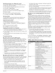
... the location of the device may not be a legend on your computer. Map datum is at least 10 V, but does not turn on, contact Garmin product support at least six seconds. You can receive the GPS signal. Capturing Screenshots 1 Insert a memory card into the card slot. 2 Select Settings... supplied to scroll through the images. 7 If necessary, select Menu > Start Slideshow. Commonly displayed as a bitmap (.bmp) file. You can manually enter a waypoint location to transfer and share data from the card and paste it should be able to the chartplotter or the NMEA network. •...
... the location of the device may not be a legend on your computer. Map datum is at least 10 V, but does not turn on, contact Garmin product support at least six seconds. You can receive the GPS signal. Capturing Screenshots 1 Insert a memory card into the card slot. 2 Select Settings... supplied to scroll through the images. 7 If necessary, select Menu > Start Slideshow. Commonly displayed as a bitmap (.bmp) file. You can manually enter a waypoint location to transfer and share data from the card and paste it should be able to the chartplotter or the NMEA network. •...