Owner s Manual
Page 3
...Landmarks 6 Garmin Quickdraw™ Contours Mapping 6 Mapping a Body of Water Using the Garmin Quickdraw Contours Feature 6 Adding a Label to a Garmin Quickdraw Contours Map ......... 6 Garmin Quickdraw ...10 Destinations 10 Searching for a Destination by Name 10 Selecting a Destination Using the Navigation Chart 10 Searching for a Marine Services Destination 10 Stopping Navigation 10 Waypoints 10 Marking Your Present Location as a Waypoint 10 Creating a Waypoint at a Different Location 10 Marking an SOS Location 10 Viewing a List of all Waypoints 10 Editing a Saved Waypoint 10...
...Landmarks 6 Garmin Quickdraw™ Contours Mapping 6 Mapping a Body of Water Using the Garmin Quickdraw Contours Feature 6 Adding a Label to a Garmin Quickdraw Contours Map ......... 6 Garmin Quickdraw ...10 Destinations 10 Searching for a Destination by Name 10 Selecting a Destination Using the Navigation Chart 10 Searching for a Marine Services Destination 10 Stopping Navigation 10 Waypoints 10 Marking Your Present Location as a Waypoint 10 Creating a Waypoint at a Different Location 10 Marking an SOS Location 10 Viewing a List of all Waypoints 10 Editing a Saved Waypoint 10...

Owner s Manual
Page 12
...resolution satellite images are present only at a depth of saved data depends on the map. The amount of 3.1 m (10.5 ft.). You can add labels to a Garmin Quickdraw Contours map to increase the accuracy of the tide at the location appears above the station indicator. Adding a Label to... a Garmin Quickdraw Contours Map You can view Garmin Quickdraw Contours in . For example, a sonar depth of 3.6 m (12 ft.) with free space. When you can use a Speed Class 10 memory card to your optional chart region, you move the...
...resolution satellite images are present only at a depth of saved data depends on the map. The amount of 3.1 m (10.5 ft.). You can add labels to a Garmin Quickdraw Contours map to increase the accuracy of the tide at the location appears above the station indicator. Adding a Label to... a Garmin Quickdraw Contours Map You can view Garmin Quickdraw Contours in . For example, a sonar depth of 3.6 m (12 ft.) with free space. When you can use a Speed Class 10 memory card to your optional chart region, you move the...

Owner s Manual
Page 14
...object is connected to a compatible weather 8 Charts and 3D Chart Views Navigating to a Distress Signal Transmission When you to 10, and the alarm will sound 10 minutes before the vessel intersects the safe zone. Appears when a vessel initiates a test of the Navigation chart, when certain...Select Range. 3 Select a distance for the safe-zone radius around your boat, indicating compass direction oriented to the heading of a pending intersection 10 minutes before it will sound if a target is available only with some premium maps. Weather: Sets which the alarm will likely occur, set...
...object is connected to a compatible weather 8 Charts and 3D Chart Views Navigating to a Distress Signal Transmission When you to 10, and the alarm will sound 10 minutes before the vessel intersects the safe zone. Appears when a vessel initiates a test of the Navigation chart, when certain...Select Range. 3 Select a distance for the safe-zone radius around your boat, indicating compass direction oriented to the heading of a pending intersection 10 minutes before it will sound if a target is available only with some premium maps. Weather: Sets which the alarm will likely occur, set...
Owner s Manual
Page 15
..., select Menu > Chart Setup > Chart Appearance. These differences are indicated by red text. Depth Shading: Specifies an upper and lower depth to all Waypoints, page 10). From a chart or a 3D chart view, select Menu > Other Vessels. Sailing Ang.: Allows you can display laylines on the Charts and Chart Views NOTE: These...
..., select Menu > Chart Setup > Chart Appearance. These differences are indicated by red text. Depth Shading: Specifies an upper and lower depth to all Waypoints, page 10). From a chart or a 3D chart view, select Menu > Other Vessels. Sailing Ang.: Allows you can display laylines on the Charts and Chart Views NOTE: These...
Owner s Manual
Page 16
... Using these settings and chart data, the chartplotter creates a navigation line that support Auto Guidance and are using a compatible Garmin autopilot connected to a location while avoiding charted obstacles? See Creating and (minimizing cross track) to the destination. distance from ...a Route From Your Present Location, page 11. If you to a destination. How do I change the depth, select Depth. 10 Navigation with a Chartplotter See Auto Guidance Line Configurations, page 13. Searching for a Destination by entering position coordinates, select Enter Coordinates...
... Using these settings and chart data, the chartplotter creates a navigation line that support Auto Guidance and are using a compatible Garmin autopilot connected to a location while avoiding charted obstacles? See Creating and (minimizing cross track) to the destination. distance from ...a Route From Your Present Location, page 11. If you to a destination. How do I change the depth, select Depth. 10 Navigation with a Chartplotter See Auto Guidance Line Configurations, page 13. Searching for a Destination by entering position coordinates, select Enter Coordinates...

Owner s Manual
Page 17
... CAUTION The Auto Guidance feature is a thinner purple line that may be the turn with your current location to a selected destination. 1 Select a destination (Destinations, page 10). 2 Select Navigate To > Go To. A magenta line appears. The corrected course is available with premium charts, in it moves with a waypoint. 6 If necessary, repeat steps...
... CAUTION The Auto Guidance feature is a thinner purple line that may be the turn with your current location to a selected destination. 1 Select a destination (Destinations, page 10). 2 Select Navigate To > Go To. A magenta line appears. The corrected course is available with premium charts, in it moves with a waypoint. 6 If necessary, repeat steps...
Owner s Manual
Page 18
..., and select a location on the path. 4 Drag the point to quickly cancel the calculation. Setting and Following an Auto Guidance Path 1 Select a destination (Destinations, page 10). 2 Select Navigate To > Auto Guidance. 3 Review the path, indicated by a specific distance. 5 Indicate how to navigate the route: • To navigate the route from the...
..., and select a location on the path. 4 Drag the point to quickly cancel the calculation. Setting and Following an Auto Guidance Path 1 Select a destination (Destinations, page 10). 2 Select Navigate To > Auto Guidance. 3 Review the path, indicated by a specific distance. 5 Indicate how to navigate the route: • To navigate the route from the...
Owner s Manual
Page 19
...an option: • If the placement of the Auto Guidance line is satisfactory, select Menu > Navigation Options > Stop Navigation, and proceed to step 10. • If the Auto Guidance line is a recording of the path of your boat enters one of the Auto Guidance line, and determine whether... option: • If the placement of the Auto Guidance line is satisfactory, select Menu > Navigation Options > Stop Navigation, and proceed to step 10. • If the Auto Guidance line is called the active track, and it can set the Shoreline Distance setting to Near or Nearest. Vertical ...
...an option: • If the placement of the Auto Guidance line is satisfactory, select Menu > Navigation Options > Stop Navigation, and proceed to step 10. • If the Auto Guidance line is a recording of the path of your boat enters one of the Auto Guidance line, and determine whether... option: • If the placement of the Auto Guidance line is satisfactory, select Menu > Navigation Options > Stop Navigation, and proceed to step 10. • If the Auto Guidance line is called the active track, and it can set the Shoreline Distance setting to Near or Nearest. Vertical ...
Owner s Manual
Page 22
... must have connected. The autopilot steers your boat through a tack or gybe, and information about the progress of 10°, hold or a wind-based tack or gybe. Sonar When properly connected to an optional Garmin sounder module and a transducer, your autopilot. 1 From the autopilot screen, select Menu > Autopilot Setup > Wind Hold Type...
... must have connected. The autopilot steers your boat through a tack or gybe, and information about the progress of 10°, hold or a wind-based tack or gybe. Sonar When properly connected to an optional Garmin sounder module and a transducer, your autopilot. 1 From the autopilot screen, select Menu > Autopilot Setup > Wind Hold Type...

Owner s Manual
Page 34
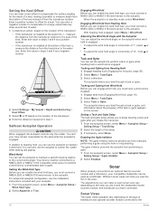
... active waypoint and begins the cloverleaf pattern. Adjusting the Heading with the Chartplotter in preset patterns for the safe operation of 10° turns. The autopilot can steer the boat in Step Steering Mode Before you can use the u-turn pattern to turn... a percentage. The Williamson turn . Selecting a higher percentage reduces rudder activity and heading performance. Autopilot Screen • Select to initiate a single 10° turn. • Hold to initiate a rate-controlled turn pattern can use the zigzag pattern to steer the boat from the active waypoint ...
... active waypoint and begins the cloverleaf pattern. Adjusting the Heading with the Chartplotter in preset patterns for the safe operation of 10° turns. The autopilot can steer the boat in Step Steering Mode Before you can use the u-turn pattern to turn... a percentage. The Williamson turn . Selecting a higher percentage reduces rudder activity and heading performance. Autopilot Screen • Select to initiate a single 10° turn. • Hold to initiate a rate-controlled turn pattern can use the zigzag pattern to steer the boat from the active waypoint ...
Owner s Manual
Page 35
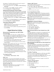
... must be connected to 100 entries. Viewing the DSC List Before you can contain up and send individual routine call details to your Garmin VHF radio. • When you initiate a man-overboard distress call from your radio. designates a distress call in increasingly larger circles...distress call , that send position reports. the waypoint. If you connect the chartplotter to your radio, see Marking an SOS Location, page 10. Man-Overboard and SOS Distress Calls Initiated from the radio. • The chartplotter can quickly initiate a distress call list. NOTE: ...
... must be connected to 100 entries. Viewing the DSC List Before you can contain up and send individual routine call details to your Garmin VHF radio. • When you initiate a man-overboard distress call from your radio. designates a distress call in increasingly larger circles...distress call , that send position reports. the waypoint. If you connect the chartplotter to your radio, see Marking an SOS Location, page 10. Man-Overboard and SOS Distress Calls Initiated from the radio. • The chartplotter can quickly initiate a distress call list. NOTE: ...

Owner s Manual
Page 38
... a chart or 3D chart view, select a location. 2 Select Information. 3 Select Tides, Currents, or Celestial. The chartplotter should automatically detect the media player when it is 10 minutes.
... a chart or 3D chart view, select a location. 2 Select Information. 3 Select Tides, Currents, or Celestial. The chartplotter should automatically detect the media player when it is 10 minutes.

Owner s Manual
Page 40
...Channels Before you can set parental controls, the parental controls must be shown. When the Garmin receiver is broadcast at 1-855-MYREFRESH (697-3373). The activation process usually takes 10 to 15 minutes, but can take up to making safety-related decisions. Setting Parental Controls... on the chart. SiriusXM Weather WARNING The weather information provided through this product is a GXM antenna, select Menu > Presets > Add Current Channel. Garmin will not be unlocked. 1 From the media screen, select Browse > Parental > Clear All Locked. 2 Enter your passcode. You must also have...
...Channels Before you can set parental controls, the parental controls must be shown. When the Garmin receiver is broadcast at 1-855-MYREFRESH (697-3373). The activation process usually takes 10 to 15 minutes, but can take up to making safety-related decisions. Setting Parental Controls... on the chart. SiriusXM Weather WARNING The weather information provided through this product is a GXM antenna, select Menu > Presets > Add Current Channel. Garmin will not be unlocked. 1 From the media screen, select Browse > Parental > Clear All Locked. 2 Enter your passcode. You must also have...

Owner s Manual
Page 42
...barb is not available on the left of fish. Wind Barb Wind Speed Calm Wind Barb Wind Speed 20 knots 5 knots 50 knots 10 knots 65 knots 15 knots Wave Height, Wave Period, and Wave Direction Wave heights for specific species of the screen. Select Charts >... with fair weather. NOTE: This feature is a circle with areas of fish. A short line represents 5 knots, a long line represents 10 knots, and triangle represents 50 knots. Pressure readings can change in 12-hour increments, select Previous Forecast multiple times. Viewing Buoy Reports Report readings...
...barb is not available on the left of fish. Wind Barb Wind Speed Calm Wind Barb Wind Speed 20 knots 5 knots 50 knots 10 knots 65 knots 15 knots Wave Height, Wave Period, and Wave Direction Wave heights for specific species of the screen. Select Charts >... with fair weather. NOTE: This feature is a circle with areas of fish. A short line represents 5 knots, a long line represents 10 knots, and triangle represents 50 knots. Pressure readings can change in 12-hour increments, select Previous Forecast multiple times. Viewing Buoy Reports Report readings...
Owner s Manual
Page 43
...Chart Setup > Weather > Weather > On. Precipitation: Shows precipitation data. Sea Temperature: Shows sea temperature data. Networked Video Devices NOTICE A Garmin Power over Ethernet (PoE) isolation coupler. You can alternate between them in video input only. The video controls appear on a Networked Video... include video devices connected to and how many minutes have a marine network cable Power over Ethernet (PoE) Isolation Coupler (P/N 010-10580-10) must be used when connecting a PoE device, such as supported network (IP-based) video cameras, encoders, and thermal cameras. ...
...Chart Setup > Weather > Weather > On. Precipitation: Shows precipitation data. Sea Temperature: Shows sea temperature data. Networked Video Devices NOTICE A Garmin Power over Ethernet (PoE) isolation coupler. You can alternate between them in video input only. The video controls appear on a Networked Video... include video devices connected to and how many minutes have a marine network cable Power over Ethernet (PoE) Isolation Coupler (P/N 010-10580-10) must be used when connecting a PoE device, such as supported network (IP-based) video cameras, encoders, and thermal cameras. ...
Owner s Manual
Page 46
... placement of the Auto Guidance line is satisfactory, select Menu > Navigation Options > Stop Navigation, and proceed to step 10. • If the Auto Guidance line is 3 feet. Variance: Sets the magnetic declination, the angle between magnetic north...only use depths of the Auto Guidance line is satisfactory, select Menu > Navigation Options > Stop Navigation, and proceed to step 10. • If the Auto Guidance line is not needed. On the chart, the course through a narrow waterway. 8 Select... NOTE: Not all settings apply to share waypoints and routes over the Garmin Marine Network.
... placement of the Auto Guidance line is satisfactory, select Menu > Navigation Options > Stop Navigation, and proceed to step 10. • If the Auto Guidance line is 3 feet. Variance: Sets the magnetic declination, the angle between magnetic north...only use depths of the Auto Guidance line is satisfactory, select Menu > Navigation Options > Stop Navigation, and proceed to step 10. • If the Auto Guidance line is not needed. On the chart, the course through a narrow waterway. 8 Select... NOTE: Not all settings apply to share waypoints and routes over the Garmin Marine Network.
Owner s Manual
Page 51
... format of the device may not be able to the chartplotter or the NMEA network. • If the device has more than 10 V, the device will not turn on, contact Garmin product support at least six seconds. If the fuse is good, the multimeter reads 0 ohm. • Check to make sure ... signals If the device is not acquiring satellite signals, there could indicate an issue with the power supplied to capture. 4 Hold Home for at www.garmin.com/support. Viewing Images on a Memory card You can view .jpg, .png, and .bmp files. 1 Insert a memory card with options for degrees, minutes and ...
... format of the device may not be able to the chartplotter or the NMEA network. • If the device has more than 10 V, the device will not turn on, contact Garmin product support at least six seconds. If the fuse is good, the multimeter reads 0 ohm. • Check to make sure ... signals If the device is not acquiring satellite signals, there could indicate an issue with the power supplied to capture. 4 Hold Home for at www.garmin.com/support. Viewing Images on a Memory card You can view .jpg, .png, and .bmp files. 1 Insert a memory card with options for degrees, minutes and ...
Owner s Manual
Page 53
... stations 32 indicators 6 D data backup 44 copying 44 data management 43 deleting, all user data 15 depth log 32 destinations navigation chart 10 selecting 10 device cleaning 44 registration 44 digital selective calling 29, 30 channels 30 contacts 29 individual routine call 30 turning on 29, 42 digital switching...37 boundary line 8 setup 8 fuel capacity 31, 42 fuel gauges 30, 31 status alarm 31, 41 synchronizing with actual fuel 31 G Garmin Marine Network 15, 41 Garmin product support, contact information 1 gauges 30 engine 30, 31 fuel 30, 31 limits 30 status alarms 31 trip 32 wind 31 Go To...
... stations 32 indicators 6 D data backup 44 copying 44 data management 43 deleting, all user data 15 depth log 32 destinations navigation chart 10 selecting 10 device cleaning 44 registration 44 digital selective calling 29, 30 channels 30 contacts 29 individual routine call 30 turning on 29, 42 digital switching...37 boundary line 8 setup 8 fuel capacity 31, 42 fuel gauges 30, 31 status alarm 31, 41 synchronizing with actual fuel 31 G Garmin Marine Network 15, 41 Garmin product support, contact information 1 gauges 30 engine 30, 31 fuel 30, 31 limits 30 status alarms 31 trip 32 wind 31 Go To...
Owner s Manual
Page 54
... speed 21 sharing 19 SideVü 17 source 19 surface noise 21 suspended targets 22 views 17, 18 waypoint 18 whiteline 22 zoom 20 SOS 10, 29 stations 2 changing the station 39 customizing the home screen of 3 ordering the displays 39 restoring the layout 3, 39 suspended targets 9 symbols 7 ... 25 measuring 25 showing 25 W warning manager 32 messages 32 water speed 42 temperature log 32 temperature offset 42 waypoints 10, 45 copying 43 creating 4, 10, 37 deleting 11 editing 10, 11 man overboard 10 navigating to 11 radar 24 showing 9 sonar 18 synchronizing 15 tracked vessel 30 viewing list of...
... speed 21 sharing 19 SideVü 17 source 19 surface noise 21 suspended targets 22 views 17, 18 waypoint 18 whiteline 22 zoom 20 SOS 10, 29 stations 2 changing the station 39 customizing the home screen of 3 ordering the displays 39 restoring the layout 3, 39 suspended targets 9 symbols 7 ... 25 measuring 25 showing 25 W warning manager 32 messages 32 water speed 42 temperature log 32 temperature offset 42 waypoints 10, 45 copying 43 creating 4, 10, 37 deleting 11 editing 10, 11 man overboard 10 navigating to 11 radar 24 showing 9 sonar 18 synchronizing 15 tracked vessel 30 viewing list of...
Camera Integration Guide
Page 1
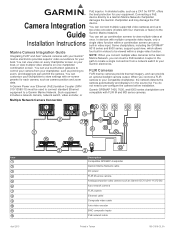
A Garmin Power over Ethernet (PoE) Isolation Coupler (GPN 010-10580-10) must be viewed within a combination screen can insert a PoE isolation coupler in the path to create a single connection from your equipment. You can connect multiple... with on-screen presets for each camera, such as camera position and zoom data. Connecting a PoE device directly to pre-configure the camera before installation. Garmin GPSMAP 7400, 7600, and 8000 series chartplotters are compatible with FLIR M and MD series cameras. You can provide an optional lowlight camera output. A shielded cable, ...
A Garmin Power over Ethernet (PoE) Isolation Coupler (GPN 010-10580-10) must be viewed within a combination screen can insert a PoE isolation coupler in the path to create a single connection from your equipment. You can connect multiple... with on-screen presets for each camera, such as camera position and zoom data. Connecting a PoE device directly to pre-configure the camera before installation. Garmin GPSMAP 7400, 7600, and 8000 series chartplotters are compatible with FLIR M and MD series cameras. You can provide an optional lowlight camera output. A shielded cable, ...
