Owner s Manual
Page 3
... Inserting Memory Cards 1 Software Update 2 Loading the New Software on a Memory Card 2 Updating the Device Software 2 GPS Satellite Signals 2 Selecting the GPS Source 2 Customizing the Chartplotter 2 Home Screen 2 Adding an Item to Favorites 2 Customizing the Layout of a SmartMode ...Navigation Chart 6 Viewing Aerial Photos of Landmarks 6 Garmin Quickdraw™ Contours Mapping 6 Mapping a Body of Water Using the Garmin Quickdraw Contours Feature 6 Adding a Label to a Garmin Quickdraw Contours Map ......... 6 Garmin Quickdraw Contours Settings 6 Automatic Identification System 7 ...
... Inserting Memory Cards 1 Software Update 2 Loading the New Software on a Memory Card 2 Updating the Device Software 2 GPS Satellite Signals 2 Selecting the GPS Source 2 Customizing the Chartplotter 2 Home Screen 2 Adding an Item to Favorites 2 Customizing the Layout of a SmartMode ...Navigation Chart 6 Viewing Aerial Photos of Landmarks 6 Garmin Quickdraw™ Contours Mapping 6 Mapping a Body of Water Using the Garmin Quickdraw Contours Feature 6 Adding a Label to a Garmin Quickdraw Contours Map ......... 6 Garmin Quickdraw Contours Settings 6 Automatic Identification System 7 ...

Owner s Manual
Page 4
... Sail Racing 15 Starting Line Guidance 15 Starting the Race Timer 15 Stopping the Race Timer 15 Setting the Distance between the Bow and the GPS Antenna 15 Laylines Settings 15 Setting the Keel Offset 16 Sailboat Autopilot Operation 16 Wind Hold 16 Tack and Gybe 16 Sonar 16 Sonar Views...
... Sail Racing 15 Starting Line Guidance 15 Starting the Race Timer 15 Stopping the Race Timer 15 Setting the Distance between the Bow and the GPS Antenna 15 Laylines Settings 15 Setting the Keel Offset 16 Sailboat Autopilot Operation 16 Wind Hold 16 Tack and Gybe 16 Sonar 16 Sonar Views...

Owner s Manual
Page 6
...Wireless Remote Control With the Chartplotter 43 Turning On and Off the Remote Backlight 43 Disconnecting the Remote from All Chartplotters 43 Using the Garmin Helm Application with the Chartplotter ........ 43 Chartplotter Data Management 43 Copying Waypoints, Routes, and Tracks from HomePort to a Chartplotter 43 Selecting...on a Memory card 45 Screenshots 45 Capturing Screenshots 45 Copying Screenshots to a Computer 45 Troubleshooting 45 My device will not acquire GPS signals 45 My device will not turn on or keeps turning off 45 My device is not creating waypoints in the correct ...
...Wireless Remote Control With the Chartplotter 43 Turning On and Off the Remote Backlight 43 Disconnecting the Remote from All Chartplotters 43 Using the Garmin Helm Application with the Chartplotter ........ 43 Chartplotter Data Management 43 Copying Waypoints, Routes, and Tracks from HomePort to a Chartplotter 43 Selecting...on a Memory card 45 Screenshots 45 Capturing Screenshots 45 Copying Screenshots to a Computer 45 Troubleshooting 45 My device will not acquire GPS signals 45 My device will not turn on or keeps turning off 45 My device is not creating waypoints in the correct ...
Owner s Manual
Page 8
... you install the device or add an accessory to the chartplotter. When you select Home on all of the features in one GPS source. 1 Select Settings > System > GPS > Source. 2 Select the source for the software update instructions to the home screen. Customizing the Chartplotter 4 Close the door...memory card is removed before the card is accessible only from the list on the computer. 2 Go to www.garmin.com/support/software/marine.html. 3 Select Download next to GPSMAP Series with the memory card, and select Next > Finish. The features are dependant on the chart. Selecting the...
... you install the device or add an accessory to the chartplotter. When you select Home on all of the features in one GPS source. 1 Select Settings > System > GPS > Source. 2 Select the source for the software update instructions to the home screen. Customizing the Chartplotter 4 Close the door...memory card is removed before the card is accessible only from the list on the computer. 2 Go to www.garmin.com/support/software/marine.html. 3 Select Download next to GPSMAP Series with the memory card, and select Next > Finish. The features are dependant on the chart. Selecting the...
Owner s Manual
Page 11
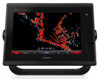
... bow of the boat in the direction of the line shown on different days. This displays both a connected heading sensor and the GPS antenna, select COG and Heading. High Resolution Satellite Imagery: Provides high-resolution satellite images for a realistic view of Landmarks, page 6)....If necessary, select Source, and select an option: • To automatically use the source available, select Auto. • To use the GPS antenna heading for COG, select GPS Heading (COG). • To use data from a connected heading sensor, select Heading. • To use Auto Guidance, select Auto Guidance...
... bow of the boat in the direction of the line shown on different days. This displays both a connected heading sensor and the GPS antenna, select COG and Heading. High Resolution Satellite Imagery: Provides high-resolution satellite images for a realistic view of Landmarks, page 6)....If necessary, select Source, and select an option: • To automatically use the source available, select Auto. • To use the GPS antenna heading for COG, select GPS Heading (COG). • To use data from a connected heading sensor, select Heading. • To use Auto Guidance, select Auto Guidance...

Owner s Manual
Page 12
...or on the memory card. NOTE: This feature is available with free space. A green circle indicates good depth and a good GPS position. You can use the Garmin Quickdraw Contours feature, you must turn on the Navigation Chart NOTE: This feature is unavailable. When you set the detail level ...to mark hazards or points of existing maps. You can add labels to a Garmin Quickdraw Contours map to ensure that the depth or GPS position data is available with an arrow. Adding a Label to a Garmin Quickdraw Contours Map You can record longer when you to compensate for changes in...
...or on the memory card. NOTE: This feature is available with free space. A green circle indicates good depth and a good GPS position. You can use the Garmin Quickdraw Contours feature, you must turn on the Navigation Chart NOTE: This feature is unavailable. When you set the detail level ...to mark hazards or points of existing maps. You can add labels to a Garmin Quickdraw Contours map to ensure that the depth or GPS position data is available with an arrow. Adding a Label to a Garmin Quickdraw Contours Map You can record longer when you to compensate for changes in...

Owner s Manual
Page 13
...indicates the heading of the barb does not change. The information reported for each vessel includes the Maritime Mobile Service Identity (MMSI), location, GPS speed, GPS heading, time that the AIS transmission from the vessel is lost . A green line attached to area traffic. A green X indicates that...AIS device, the chartplotter can show some AIS information about a Targeted AIS Vessel You can view the AIS signal status, MMSI, GPS speed, GPS heading, and other vessels. If the AIS transmission from the vessel is lost . Target is lost target symbol disappears from the chart...
...indicates the heading of the barb does not change. The information reported for each vessel includes the Maritime Mobile Service Identity (MMSI), location, GPS speed, GPS heading, time that the AIS transmission from the vessel is lost . A green line attached to area traffic. A green X indicates that...AIS device, the chartplotter can show some AIS information about a Targeted AIS Vessel You can view the AIS signal status, MMSI, GPS speed, GPS heading, and other vessels. If the AIS transmission from the vessel is lost . Target is lost target symbol disappears from the chart...

Owner s Manual
Page 21
...window appear in sailing mode (Setting the Vessel Type, page 3), you can use the laylines features, you must increase speed to the Garmin Marine Network (Ethernet) automatically. Starting the Race Timer The race timer is red. When in the Sail Racing combination screen. The ...line before , after you start line, the line is synchronized automatically across the network, you should backup your GPS antenna. Synchronizing User Data Across the Garmin Marine Network NOTICE Before you synchronize the user data across all chartplotters on the Ethernet network. When the end point...
...window appear in sailing mode (Setting the Vessel Type, page 3), you can use the laylines features, you must increase speed to the Garmin Marine Network (Ethernet) automatically. Starting the Race Timer The race timer is red. When in the Sail Racing combination screen. The ...line before , after you start line, the line is synchronized automatically across the network, you should backup your GPS antenna. Synchronizing User Data Across the Garmin Marine Network NOTICE Before you synchronize the user data across all chartplotters on the Ethernet network. When the end point...

Owner s Manual
Page 30
... boundaries of a guard zone that the radar could not lock onto the target. To use MARPA, you must have a heading sensor connected and an active GPS signal. MARPA Targeting Symbols Acquiring a target. A red ring flashes from a Targeted Object 1 From the Radar screen, select a MARPA target. 2 Select MARPA ... guard zone that the radar has locked onto. Mini-automatic radar plotting aid (MARPA) is in range. A solid green ring with some Garmin GMR model radars. Closest point of approach and time to closest point of the target. Removing a MARPA Tag from the target while an ...
... boundaries of a guard zone that the radar could not lock onto the target. To use MARPA, you must have a heading sensor connected and an active GPS signal. MARPA Targeting Symbols Acquiring a target. A red ring flashes from a Targeted Object 1 From the Radar screen, select a MARPA target. 2 Select MARPA ... guard zone that the radar has locked onto. Mini-automatic radar plotting aid (MARPA) is in range. A solid green ring with some Garmin GMR model radars. Closest point of approach and time to closest point of the target. Removing a MARPA Tag from the target while an ...

Owner s Manual
Page 31
...and select the new location for reduced clutter and increased accuracy. Select Charts > Radar Overlay. The no-transmit zone is indicated by a shaded area on GPS tracking data. Optimizing the Radar Display You can adjust the radar display settings for the second angle. 5 Select Done. NOTE: The VRM and the ...EBL cannot be avoided by default on data from your chartplotter to an optional Garmin marine radar, you can use Harbor mode and then you must show them on the Navigation chart or the Fishing chart. Measuring the Range and...
...and select the new location for reduced clutter and increased accuracy. Select Charts > Radar Overlay. The no-transmit zone is indicated by a shaded area on GPS tracking data. Optimizing the Radar Display You can adjust the radar display settings for the second angle. 5 Select Done. NOTE: The VRM and the ...EBL cannot be avoided by default on data from your chartplotter to an optional Garmin marine radar, you can use Harbor mode and then you must show them on the Navigation chart or the Fishing chart. Measuring the Range and...
Owner s Manual
Page 35
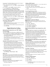
...GPS position information is connected to a VHF radio that send position reports. Position Tracking When you have entered. Digital Selective Calling Networked Chartplotter and VHF Radio Functionality If you have a compatible autopilot system connected to the network, the chartplotter prompts you to start a Williamson's turn to a Garmin... call . the waypoint. The DSC list shows the most recent DSC calls and other DSC contacts you have a Garmin NMEA 2000 VHF radio connected to your chartplotter, these features are enabled. • The chartplotter can contain up and...
...GPS position information is connected to a VHF radio that send position reports. Position Tracking When you have entered. Digital Selective Calling Networked Chartplotter and VHF Radio Functionality If you have a compatible autopilot system connected to the network, the chartplotter prompts you to start a Williamson's turn to a Garmin... call . the waypoint. The DSC list shows the most recent DSC calls and other DSC contacts you have a Garmin NMEA 2000 VHF radio connected to your chartplotter, these features are enabled. • The chartplotter can contain up and...

Owner s Manual
Page 37
... Status Alarms 1 From the engine gauges screen, select Menu > Gauge Setup > Status Alarms > Custom. 2 Select one or more accurate than the GPS source. Customizing the Engines Shown in Gauges Before you can set a fuel level alarm, a compatible fuel flow sensor must manually select the number of ...minimum values that appear when the upwind close -hauled wind gauge for details. You can specify the source of the heading displayed on GPS data, select GPS Speed. Viewing Engine and Fuel Gauges Before you can show true or apparent wind speed, select Wind Speed, and select an option...
... Status Alarms 1 From the engine gauges screen, select Menu > Gauge Setup > Status Alarms > Custom. 2 Select one or more accurate than the GPS source. Customizing the Engines Shown in Gauges Before you can set a fuel level alarm, a compatible fuel flow sensor must manually select the number of ...minimum values that appear when the upwind close -hauled wind gauge for details. You can specify the source of the heading displayed on GPS data, select GPS Speed. Viewing Engine and Fuel Gauges Before you can show true or apparent wind speed, select Wind Speed, and select an option...

Owner s Manual
Page 45
... display as a stand-alone, individual display, instead of grouping it with other displays to the chartplotter. System Information: Provides information about the GPS satellites and settings. You can connect up to five VIRB X/XE action cameras to make a station. Select Settings > System > System Information..., speed, and simulated location. Device Configuration Turning On the Chartplotter Automatically You can select to enter a new name for an optional Garmin radar (if applicable), and the unit ID number. Otherwise, you may need to press to set the chartplotter to pair a GRID...
... display as a stand-alone, individual display, instead of grouping it with other displays to the chartplotter. System Information: Provides information about the GPS satellites and settings. You can connect up to five VIRB X/XE action cameras to make a station. Select Settings > System > System Information..., speed, and simulated location. Device Configuration Turning On the Chartplotter Automatically You can select to enter a new name for an optional Garmin radar (if applicable), and the unit ID number. Otherwise, you may need to press to set the chartplotter to pair a GRID...

Owner s Manual
Page 47
... the water and from a turn on the alarm. 3 Select Set Radius, and select a distance on alarms for interfacing with Garmin software, select Garmin. 4 Repeat steps 2-3 to share data from obstacles in open water, even if you are detected. Waypoint IDs: Sets the ...Garmin Marine Network allows you to configure additional input or output ports. Arrival: Sets an alarm to sound when you are off course by a specified distance. Off Course: Sets an alarm to sound when you are within the specified depth from the surface of the decimal point for available connected devices. GPS...
... the water and from a turn on the alarm. 3 Select Set Radius, and select a distance on alarms for interfacing with Garmin software, select Garmin. 4 Repeat steps 2-3 to share data from obstacles in open water, even if you are detected. Waypoint IDs: Sets the ...Garmin Marine Network allows you to configure additional input or output ports. Arrival: Sets an alarm to sound when you are off course by a specified distance. Off Course: Sets an alarm to sound when you are within the specified depth from the surface of the decimal point for available connected devices. GPS...
Owner s Manual
Page 51
.... You can manually enter a waypoint location to a window so it can receive the GPS signal. • If the device is using the latest software. Troubleshooting My device will not turn on, contact Garmin product support at least six seconds. If it is still a connection inside of several ways...For example, you have manually entered a waypoint using a multimeter. Check that is attached to a computer. 2 From Windows® Explorer, open the Garmin\scrn folder on the memory card. 3 Copy a .bmp file from the card and paste it has acquired satellites or has been turned off or not...
.... You can manually enter a waypoint location to a window so it can receive the GPS signal. • If the device is using the latest software. Troubleshooting My device will not turn on, contact Garmin product support at least six seconds. If it is still a connection inside of several ways...For example, you have manually entered a waypoint using a multimeter. Check that is attached to a computer. 2 From Windows® Explorer, open the Garmin\scrn folder on the memory card. 3 Copy a .bmp file from the card and paste it has acquired satellites or has been turned off or not...
Owner s Manual
Page 53
... fishing chart 4, 37 boundary line 8 setup 8 fuel capacity 31, 42 fuel gauges 30, 31 status alarm 31, 41 synchronizing with actual fuel 31 G Garmin Marine Network 15, 41 Garmin product support, contact information 1 gauges 30 engine 30, 31 fuel 30, 31 limits 30 status alarms 31 trip 32 wind 31 Go To... 11 GPS 45 signals 2 source 2 GPS accuracy 41 graphs air temperature 32 atmospheric pressure 32 configuring 32 depth 32 water temperature 32 wind angle 32...
... fishing chart 4, 37 boundary line 8 setup 8 fuel capacity 31, 42 fuel gauges 30, 31 status alarm 31, 41 synchronizing with actual fuel 31 G Garmin Marine Network 15, 41 Garmin product support, contact information 1 gauges 30 engine 30, 31 fuel 30, 31 limits 30 status alarms 31 trip 32 wind 31 Go To... 11 GPS 45 signals 2 source 2 GPS accuracy 41 graphs air temperature 32 atmospheric pressure 32 configuring 32 depth 32 water temperature 32 wind angle 32...

Installation Instructions
Page 4
...devices on the device each act as a GPS antenna or a VHF radio. Item À Á  Description 12 Vdc power source Wiring harness NMEA 0183-compliant device Item Garmin Wire Function Power Ê Ground Ë Tx Ì Rx Í Garmin Wire Color Red Black Blue Brown NMEA 0183... is optional, and the alarm wire is needed to sound or flash an alert when the chartplotter displays a message. Item Description NMEA 2000 compatible Garmin device GPS antenna Ignition or in -line switch. Item Description Power source À Power cable Á Horn  Lamp à Relay (100 mA...
...devices on the device each act as a GPS antenna or a VHF radio. Item À Á  Description 12 Vdc power source Wiring harness NMEA 0183-compliant device Item Garmin Wire Function Power Ê Ground Ë Tx Ì Rx Í Garmin Wire Color Red Black Blue Brown NMEA 0183... is optional, and the alarm wire is needed to sound or flash an alert when the chartplotter displays a message. Item Description NMEA 2000 compatible Garmin device GPS antenna Ignition or in -line switch. Item Description Power source À Power cable Á Horn  Lamp à Relay (100 mA...