Technical Reference for Garmin NMEA 2000 Products
Page 2
...;, GMI™, GRA™, GET™, GHC™, Intelliducer™, are trademarks of Garmin Ltd. Garmin®, the Garmin logo, and GPSMAP® are trademarks of Garmin Ltd. Garmin reserves the right to change without obligation to print one copy of this manual or of any revision hereto, provided that such electronic or printed copy of this...
...;, GMI™, GRA™, GET™, GHC™, Intelliducer™, are trademarks of Garmin Ltd. Garmin®, the Garmin logo, and GPSMAP® are trademarks of Garmin Ltd. Garmin reserves the right to change without obligation to print one copy of this manual or of any revision hereto, provided that such electronic or printed copy of this...
Technical Reference for Garmin NMEA 2000 Products
Page 17
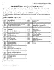
... Display Device PGN Information NMEA 2000-Certified Display Device PGN Information All data transmitted on every available Garmin NMEA 2000-certified display device, see the owner's manual for your display device. Command/Request/Acknowledge Group Function Transmit/Receive PGN List Group Function Product Information... 127493 Transmission Parameters, Dynamic 127505 Fluid Level 128259 Speed - Water Referenced 128267 Water Depth 129025 Position - GPSMAP 6000/7000 Series Chartplotters Receive 059392 ISO Acknowledgment 059904 ISO Request 060928 ISO Address Claim 126208 NMEA -
... Display Device PGN Information NMEA 2000-Certified Display Device PGN Information All data transmitted on every available Garmin NMEA 2000-certified display device, see the owner's manual for your display device. Command/Request/Acknowledge Group Function Transmit/Receive PGN List Group Function Product Information... 127493 Transmission Parameters, Dynamic 127505 Fluid Level 128259 Speed - Water Referenced 128267 Water Depth 129025 Position - GPSMAP 6000/7000 Series Chartplotters Receive 059392 ISO Acknowledgment 059904 ISO Request 060928 ISO Address Claim 126208 NMEA -
Technical Reference for Garmin NMEA 2000 Products
Page 29
...fuel level changes with the motion of the boat. When the boat is connected to a specific engine. • Tank Number-for Garmin NMEA 2000 Products 25 Troubleshooting the Fuel-Flow Reading If the fuel-flow information received from the following options: • Engine Number-for...test the gauge-type setting: 1. Choose 1 Coil or 2 Coil and repeat the gauge-type setting test. Restoring Factory Default Settings You can manually adjust the fuel-flow reading. Perform this test when the boat is associated with each GFS 10. Enter a positive or negative adjustment. While...
...fuel level changes with the motion of the boat. When the boat is connected to a specific engine. • Tank Number-for Garmin NMEA 2000 Products 25 Troubleshooting the Fuel-Flow Reading If the fuel-flow information received from the following options: • Engine Number-for...test the gauge-type setting: 1. Choose 1 Coil or 2 Coil and repeat the gauge-type setting test. Restoring Factory Default Settings You can manually adjust the fuel-flow reading. Perform this test when the boat is associated with each GFS 10. Enter a positive or negative adjustment. While...
Important Safety and Product Information
Page 2
... not available or is provided in product literature and copyright messages displayed to the consumer. This Notice is prohibitively expensive. See www.garmin.com/prop65 for any discrepancies or questions before continuing navigation. • Use the electronic chart in death or serious injury. Important ... cause an accident or collision resulting in property damage, serious injury, or death. • NOTE: Refer to your product's owner's manual to determine if your product contains or accepts maps, or to determine if your unit contains or accepts mapping products, follow these guidelines ...
... not available or is provided in product literature and copyright messages displayed to the consumer. This Notice is prohibitively expensive. See www.garmin.com/prop65 for any discrepancies or questions before continuing navigation. • Use the electronic chart in death or serious injury. Important ... cause an accident or collision resulting in property damage, serious injury, or death. • NOTE: Refer to your product's owner's manual to determine if your product contains or accepts maps, or to determine if your unit contains or accepts mapping products, follow these guidelines ...
XM Supplement
Page 2
... person or organization of this manual onto a hard drive or other electronic storage medium to be reproduced, copied, transmitted, disseminated, downloaded or stored in the USA and other Garmin products. Garmin®, the Gamin logo, GPSMAP®, BlueChart®, and g2 Vision® are registered trademarks of Garmin. © 2010 Garmin Ltd. DAFIF™ is subject...
... person or organization of this manual onto a hard drive or other electronic storage medium to be reproduced, copied, transmitted, disseminated, downloaded or stored in the USA and other Garmin products. Garmin®, the Gamin logo, GPSMAP®, BlueChart®, and g2 Vision® are registered trademarks of Garmin. © 2010 Garmin Ltd. DAFIF™ is subject...
XM Supplement
Page 3
... and click Contact Support for your chartplotter. In the USA, go to the owner's manual for in-country support information, or contact Garmin (Europe) Ltd. In Europe, go to www.garmin.com/support, or contact Garmin USA by phone at +44 (0) 870.8501241. 700 Series XM WX Satellite Weather®.... Simulator mode does not supply live weather data. by phone at (913) 397.8200 or (800) 800.1020. Contact Garmin Contact Garmin Product Support if you have a Garmin XM satellite radio receiver and an XM Satellite Radio subscription. If you do not have a receiver and a subscription to use ...
... and click Contact Support for your chartplotter. In the USA, go to the owner's manual for in-country support information, or contact Garmin (Europe) Ltd. In Europe, go to www.garmin.com/support, or contact Garmin USA by phone at +44 (0) 870.8501241. 700 Series XM WX Satellite Weather®.... Simulator mode does not supply live weather data. by phone at (913) 397.8200 or (800) 800.1020. Contact Garmin Contact Garmin Product Support if you have a Garmin XM satellite radio receiver and an XM Satellite Radio subscription. If you do not have a receiver and a subscription to use ...
XM Supplement
Page 14
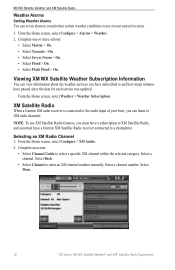
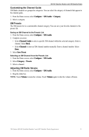
...select Configure > Alarms > Weather. 2. XM Satellite Radio When a Garmin XM radio receiver is connected to the audio input of your current location. 1. Complete an action: • Select Channel Guide to enter an XM channel number manually. Select Done. 10 700 Series XM WX Satellite Weather® and... about the weather services you must have a subscription to XM Satellite Radio, and you have subscribed to and how many minutes have a Garmin XM Satellite Radio receiver connected to a chartplotter. Selecting an XM Radio Channel 1. Note: To use XM Satellite Radio features, you must...
...select Configure > Alarms > Weather. 2. XM Satellite Radio When a Garmin XM radio receiver is connected to the audio input of your current location. 1. Complete an action: • Select Channel Guide to enter an XM channel number manually. Select Done. 10 700 Series XM WX Satellite Weather® and... about the weather services you must have a subscription to XM Satellite Radio, and you have subscribed to and how many minutes have a Garmin XM Satellite Radio receiver connected to a chartplotter. Selecting an XM Radio Channel 1. Note: To use XM Satellite Radio features, you must...
XM Supplement
Page 15
... the Presets List 1. Select Done. 3. Selecting an XM Channel from the Presets List 1. Select Category > Presets. 3. Touch Volume again to enter an XM channel number manually. You can select the category of channels that appear in categories. Select a channel. Select Save Preset. Select a channel. Enter a channel number. XM WX Satellite Weather...
... the Presets List 1. Select Done. 3. Selecting an XM Channel from the Presets List 1. Select Category > Presets. 3. Touch Volume again to enter an XM channel number manually. You can select the category of channels that appear in categories. Select a channel. Select Save Preset. Select a channel. Enter a channel number. XM WX Satellite Weather...
Installation Instructions
Page 5
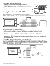
...0183 ground on the fuse block of the boat). - See the GPSMAP 700 Series Owner's Manual for wire identification. 2. Connecting the Power/Data Cable to a Lamp or to a Horn (Optional) The GPSMAP 700 series chartplotter can connect the GPSMAP 700 series chartplotter to other NMEA 0183-compatible + To device Fuse Block.... Wire 10-35 Vdc Fuse Color 3 A Red (power) Black (gnd) Yellow (alarm) Relay 100 ma max coil current Wiring to Power 1. For Garmin devices, the ground (black) wires serve as a DSC or AIS device. Connecting the Power/Data Cable to a Lamp, a Horn, or Both Horn Lamp...
...0183 ground on the fuse block of the boat). - See the GPSMAP 700 Series Owner's Manual for wire identification. 2. Connecting the Power/Data Cable to a Lamp or to a Horn (Optional) The GPSMAP 700 series chartplotter can connect the GPSMAP 700 series chartplotter to other NMEA 0183-compatible + To device Fuse Block.... Wire 10-35 Vdc Fuse Color 3 A Red (power) Black (gnd) Yellow (alarm) Relay 100 ma max coil current Wiring to Power 1. For Garmin devices, the ground (black) wires serve as a DSC or AIS device. Connecting the Power/Data Cable to a Lamp, a Horn, or Both Horn Lamp...

Quick Reference Guide
Page 2
...safe obstacle height. 6. Use visual sightings and steer to avoid land, shallow water, and other screen by the magenta line. Garmin®, the Gamin logo, GPSMAP®, BlueChart®, and g2 Vision® are trademarks of time until you want to a new location. Creating a ... clearance. Review the course indicated by touching Mark at a Different Location 1. Note: Auto Guidance is based on ambient light. • Adjust the slider manually. Complete an action: • Select Go To. • Select Route To. • Select Guide To to each. 3. Adjusting the Backlight Adjusting...
...safe obstacle height. 6. Use visual sightings and steer to avoid land, shallow water, and other screen by the magenta line. Garmin®, the Gamin logo, GPSMAP®, BlueChart®, and g2 Vision® are trademarks of time until you want to a new location. Creating a ... clearance. Review the course indicated by touching Mark at a Different Location 1. Note: Auto Guidance is based on ambient light. • Adjust the slider manually. Complete an action: • Select Go To. • Select Route To. • Select Guide To to each. 3. Adjusting the Backlight Adjusting...
Owner's Manual
Page 1
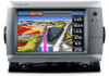
GPSMAP® 700 series owner's manual
GPSMAP® 700 series owner's manual

Owner's Manual
Page 2
... storage medium, for current updates and supplemental information concerning the use and operation of this manual or any purpose without notice. Garmin®, the Garmin logo, GPSMAP®, BlueChart®, g2 Vision®, and MapSource® are trademarks of Garmin Ltd. or its subsidiaries, registered in the United States and other countries. or its products...
... storage medium, for current updates and supplemental information concerning the use and operation of this manual or any purpose without notice. Garmin®, the Garmin logo, GPSMAP®, BlueChart®, g2 Vision®, and MapSource® are trademarks of Garmin Ltd. or its subsidiaries, registered in the United States and other countries. or its products...
Owner's Manual
Page 3
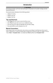
Manual Conventions In this manual, when you are instructed to select an item, use your finger to select it. Introduction Introduction ...should touch Charts and then touch Navigation Chart. This manual includes information for product warnings and other important information. Small arrows (>) in the product box for the following products: • GPSMAP® 720/720s • GPSMAP 740/740s • GPSMAP 750/750s Tips and Shortcuts • Select Home...to turn the chartplotter on the screen to touch that you should select each item in order. GPSMAP 700 Series Owner's Manual i
Manual Conventions In this manual, when you are instructed to select an item, use your finger to select it. Introduction Introduction ...should touch Charts and then touch Navigation Chart. This manual includes information for product warnings and other important information. Small arrows (>) in the product box for the following products: • GPSMAP® 720/720s • GPSMAP 740/740s • GPSMAP 750/750s Tips and Shortcuts • Select Home...to turn the chartplotter on the screen to touch that you should select each item in order. GPSMAP 700 Series Owner's Manual i

Owner's Manual
Page 4
...22 Combination Screen Configuration 22 Navigation 25 Basic Navigation Questions 25 Navigation with a Chartplotter 25 Waypoints 26 Routes 28 Tracks 30 Navigating with a Garmin Autopilot 32 Where To 33 Marine Services Destinations 33 Almanac, On-boat, and Environmental Data 36 Almanac Data 36 On-boat Data 38 ...GPS Satellite Locations 85 Using WAAS/EGNOS 85 System Information 85 NMEA 0183 and NMEA 2000 86 Registering Your Device 89 Contacting Garmin Product Support 89 Declaration of Conformity 89 Software License Agreement 89 Index 90 ii GPSMAP 700 Series Owner's Manual
...22 Combination Screen Configuration 22 Navigation 25 Basic Navigation Questions 25 Navigation with a Chartplotter 25 Waypoints 26 Routes 28 Tracks 30 Navigating with a Garmin Autopilot 32 Where To 33 Marine Services Destinations 33 Almanac, On-boat, and Environmental Data 36 Almanac Data 36 On-boat Data 38 ...GPS Satellite Locations 85 Using WAAS/EGNOS 85 System Information 85 NMEA 0183 and NMEA 2000 86 Registering Your Device 89 Contacting Garmin Product Support 89 Declaration of Conformity 89 Software License Agreement 89 Index 90 ii GPSMAP 700 Series Owner's Manual
Owner's Manual
Page 5
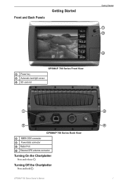
GPSMAP 700 Series Owner's Manual ➋ ➍ 1 Turning Off the Chartplotter Press and hold . Front and Back Panels Getting Started Getting Started ➊ ➋ ➌ GPSMAP 700 Series Front View ➊ Power key ➋ Automatic backlight sensor ➌ SD card slot ➊ ➌ GPSMAP 700 Series Back View ➊ NMEA 2000 connector ➋ Power/data connector ➌ Radar Port ➍ External GPS antenna connector Turning On the Chartplotter Press and release .
GPSMAP 700 Series Owner's Manual ➋ ➍ 1 Turning Off the Chartplotter Press and hold . Front and Back Panels Getting Started Getting Started ➊ ➋ ➌ GPSMAP 700 Series Front View ➊ Power key ➋ Automatic backlight sensor ➌ SD card slot ➊ ➌ GPSMAP 700 Series Back View ➊ NMEA 2000 connector ➋ Power/data connector ➌ Radar Port ➍ External GPS antenna connector Turning On the Chartplotter Press and release .
Owner's Manual
Page 6
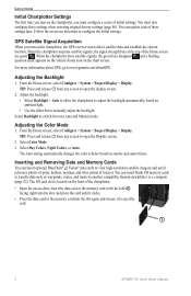
... From the Home screen, select Configure > System > Beeper/Display > Display. For more information about GPS, go to switch between Auto and Manual mode. Adjusting the Backlight 1. You can update each of the chartplotter. • Open the access door, insert the data card or the ...• Use the slider bar to eject the card. ➊ 2 GPSMAP 700 Series Owner's Manual Getting Started Initial Chartplotter Settings The first time you must also configure these settings later. Select Backlight to www.garmin.com/aboutGPS. TIP: Press and release from any screen to view high...
... From the Home screen, select Configure > System > Beeper/Display > Display. For more information about GPS, go to switch between Auto and Manual mode. Adjusting the Backlight 1. You can update each of the chartplotter. • Open the access door, insert the data card or the ...• Use the slider bar to eject the card. ➊ 2 GPSMAP 700 Series Owner's Manual Getting Started Initial Chartplotter Settings The first time you must also configure these settings later. Select Backlight to www.garmin.com/aboutGPS. TIP: Press and release from any screen to view high...
Owner's Manual
Page 7
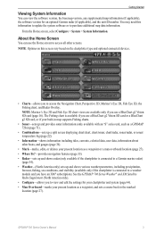
...for your chartplotter and system (page 44). • Man Overboard-marks your present location as a waypoint, and sets a course back to a Garmin marine radar) (page 54). • Weather-(North America only) sets up and shows various weather parameters, including precipitation, forecast, fishing, sea ... chartplotter is available if you have an XM® subscription). From the Home screen, select Configure > System > System Information. GPSMAP 700 Series Owner's Manual 3 The Fishing chart is connected to a weather module and you use a BlueChart g2 Vision SD card or a BlueChart g2 ...
...for your chartplotter and system (page 44). • Man Overboard-marks your present location as a waypoint, and sets a course back to a Garmin marine radar) (page 54). • Weather-(North America only) sets up and shows various weather parameters, including precipitation, forecast, fishing, sea ... chartplotter is available if you have an XM® subscription). From the Home screen, select Configure > System > System Information. GPSMAP 700 Series Owner's Manual 3 The Fishing chart is connected to a weather module and you use a BlueChart g2 Vision SD card or a BlueChart g2 ...
Owner's Manual
Page 8
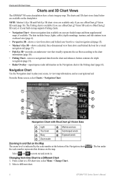
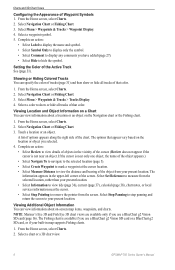
...-shows navigation data available on the Navigation chart or the Fishing chart (page 61). Select a different chart. ). The bar under 4 GPSMAP 700 Series Owner's Manual Navigation Chart Use the Navigation chart to plan your pre-loaded maps and from One Chart to zoom out and zoom in an overhead...chartplotter. From a chart or a 3D chart view, select Menu > Change Chart. 2. Charts and 3D Chart Views Charts and 3D Chart Views The GPSMAP 700 series chartplotters have a basic imagery map. Note: Mariner's Eye 3D and Fish Eye 3D chart views are available on the map. Changing from...
...-shows navigation data available on the Navigation chart or the Fishing chart (page 61). Select a different chart. ). The bar under 4 GPSMAP 700 Series Owner's Manual Navigation Chart Use the Navigation chart to plan your pre-loaded maps and from One Chart to zoom out and zoom in an overhead...chartplotter. From a chart or a 3D chart view, select Menu > Change Chart. 2. Charts and 3D Chart Views Charts and 3D Chart Views The GPSMAP 700 series chartplotters have a basic imagery map. Note: Mariner's Eye 3D and Fish Eye 3D chart views are available on the map. Changing from...
Owner's Manual
Page 9
... screen to your built-in white), intertidal zones, spot soundings (as depicted on the Navigation chart, the Fishing chart, or the Radar Overlay. GPSMAP 700 Series Owner's Manual 5 Carefully compare the course to all visual sightings and avoid any part of the Auto Guidance line. Note: The Fishing chart is available if...
... screen to your built-in white), intertidal zones, spot soundings (as depicted on the Navigation chart, the Fishing chart, or the Radar Overlay. GPSMAP 700 Series Owner's Manual 5 Carefully compare the course to all visual sightings and avoid any part of the Auto Guidance line. Note: The Fishing chart is available if...
Owner's Manual
Page 10
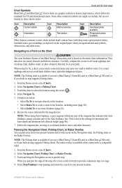
... chart or the Fishing chart. 1. Select Navigation Chart or Fishing Chart. 3. From the Home screen, select Charts. 2. Select a chart or a 3D chart view. 6 GPSMAP 700 Series Owner's Manual Complete an action: • Select Label to display the name and symbol. • Select Symbol Only to display only the symbol. • Select Comment...
... chart or the Fishing chart. 1. Select Navigation Chart or Fishing Chart. 3. From the Home screen, select Charts. 2. Select a chart or a 3D chart view. 6 GPSMAP 700 Series Owner's Manual Complete an action: • Select Label to display the name and symbol. • Select Symbol Only to display only the symbol. • Select Comment...

