Owner's Manual
Page 3
... select it. Small arrows (>) in order. This manual includes information for product warnings and other important information. Introduction Introduction WARNING See the Important Safety and Product Information guide in the product box for the following products: • GPSMAP® 720/720s • GPSMAP 740/740s • GPSMAP 750/750s Tips and Shortcuts • Select Home...
... select it. Small arrows (>) in order. This manual includes information for product warnings and other important information. Introduction Introduction WARNING See the Important Safety and Product Information guide in the product box for the following products: • GPSMAP® 720/720s • GPSMAP 740/740s • GPSMAP 750/750s Tips and Shortcuts • Select Home...
Owner's Manual
Page 7
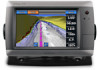
...built-in map supports Fishing charts. • Sonar-sets up and provides sonar information (only available with an "S" series unit, such as a GPSMAP 720s) (page 71). • Combinations-sets up and shows various weather parameters, including precipitation, forecast, fishing, sea conditions, and visibility (available only...chartplotter is connected to a weather module and you to view and edit the settings for an optional Garmin radar (if applicable), and the unit ID number. GPSMAP 700 Series Owner's Manual 3 The Fishing chart is available if you use a BlueChart g2 Vision SD card (page 16...
...built-in map supports Fishing charts. • Sonar-sets up and provides sonar information (only available with an "S" series unit, such as a GPSMAP 720s) (page 71). • Combinations-sets up and shows various weather parameters, including precipitation, forecast, fishing, sea conditions, and visibility (available only...chartplotter is connected to a weather module and you to view and edit the settings for an optional Garmin radar (if applicable), and the unit ID number. GPSMAP 700 Series Owner's Manual 3 The Fishing chart is available if you use a BlueChart g2 Vision SD card (page 16...
Owner's Manual
Page 52
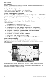
...The compass tape can be shown or hidden in sounder to create a customized system of measurement for each overlay. 48 GPSMAP 700 Series Owner's Manual You can select the data fields to be receiving NMEA Sonar depth data or using a standardized system of measurements or ...data overlay. Device Configuration Units of Measure You can set the units of measure the chartplotter shows, using an "S" series chartplotter (such as a GPSMAP 720s) with data fields ➊ can appear on the chart, the navigation inset is shown during navigation. Select Statute (mh, ft, ºF), ...
...The compass tape can be shown or hidden in sounder to create a customized system of measurement for each overlay. 48 GPSMAP 700 Series Owner's Manual You can select the data fields to be receiving NMEA Sonar depth data or using a standardized system of measurements or ...data overlay. Device Configuration Units of Measure You can set the units of measure the chartplotter shows, using an "S" series chartplotter (such as a GPSMAP 720s) with data fields ➊ can appear on the chart, the navigation inset is shown during navigation. Select Statute (mh, ft, ºF), ...

Owner's Manual
Page 75
... in on sonar data from a transducer. Full-screen Sonar View The full-screen sonar view shows a full-view graph of the magnified area manually. Complete an action: • Select 2x Auto Zoom to zoom in on the sonar data at two-times magnification. • Select 4x ...the right to the left. GPSMAP 700 Series Owner's Manual 71 From the Home screen, select Sonar > Full Screen > Menu > Zoom. 2. The range scale along the right side of the screen shows the depth of detected objects as fishfinders: • GPSMAP 720s • GPSMAP 740s • GPSMAP 750s Sonar Views The chartplotter ...
... in on sonar data from a transducer. Full-screen Sonar View The full-screen sonar view shows a full-view graph of the magnified area manually. Complete an action: • Select 2x Auto Zoom to zoom in on the sonar data at two-times magnification. • Select 4x ...the right to the left. GPSMAP 700 Series Owner's Manual 71 From the Home screen, select Sonar > Full Screen > Menu > Zoom. 2. The range scale along the right side of the screen shows the depth of detected objects as fishfinders: • GPSMAP 720s • GPSMAP 740s • GPSMAP 750s Sonar Views The chartplotter ...


