Technical Reference for Garmin NMEA 2000 Products
Page 3
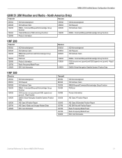
... General NMEA 2000 Data Type Requirements, provides a table to www.garmin.com/support and click Contact Support for the following products: ◦ GPSMAP® 4000/5000/6000/7000 Series chartplotters ◦ GPSMAP 700 Series chartplotters ◦ GPSMAP 4x1/5x1/5x6 Series chartplotters ◦ GMI™ 10 ◦...GHC™ 10) ◦ GXM™ 51 ◦ VHF 200/300 ◦ AIS 300 ◦ AIS 600 Note: PGN information is also included in the installation instructions provided with each Garmin NMEA 2000-certified sensor. • At the end is also included in -country support ...
... General NMEA 2000 Data Type Requirements, provides a table to www.garmin.com/support and click Contact Support for the following products: ◦ GPSMAP® 4000/5000/6000/7000 Series chartplotters ◦ GPSMAP 700 Series chartplotters ◦ GPSMAP 4x1/5x1/5x6 Series chartplotters ◦ GMI™ 10 ◦...GHC™ 10) ◦ GXM™ 51 ◦ VHF 200/300 ◦ AIS 300 ◦ AIS 600 Note: PGN information is also included in the installation instructions provided with each Garmin NMEA 2000-certified sensor. • At the end is also included in -country support ...
Technical Reference for Garmin NMEA 2000 Products
Page 4
...19 Intelliducer (Intelligent Depth Transducer-Transom Mount and Thru-Hull)...19 GWS 10 (Garmin Wind Sensor)...20 GHP 10 (Marine Autopilot System)...20 GXM 51...21 VHF 200...21 VHF 300...21 AIS 300...22 AIS 600...22 NMEA 2000-Certified Sensor Configuration Information...23 GPS 17x (GPS Antenna)......23 GFS 10 (Garmin Fuel Sensor)...24 GRA 10 (Garmin Rudder Angle Adapter)...26 GET 10 (Garmin Engine Tilt Adapter)...27 GFL 10 (Garmin Fluid Level Adapter)...29 Restoring ...
...19 Intelliducer (Intelligent Depth Transducer-Transom Mount and Thru-Hull)...19 GWS 10 (Garmin Wind Sensor)...20 GHP 10 (Marine Autopilot System)...20 GXM 51...21 VHF 200...21 VHF 300...21 AIS 300...22 AIS 600...22 NMEA 2000-Certified Sensor Configuration Information...23 GPS 17x (GPS Antenna)......23 GFS 10 (Garmin Fuel Sensor)...24 GRA 10 (Garmin Rudder Angle Adapter)...26 GET 10 (Garmin Engine Tilt Adapter)...27 GFL 10 (Garmin Fluid Level Adapter)...29 Restoring ...
Technical Reference for Garmin NMEA 2000 Products
Page 17
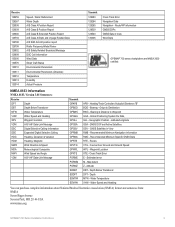
...group. Water Referenced 128267 Water Depth 129025 Position - Rapid Update 129029 GNSS Position Data 129038 AIS Class A Position Report 129039 AIS Class B Position Report 129040 AIS Class B Extended position report 129539 GNSS DOPs 129540 GNSS Sats in View Wind Data Temperature ...Acknowledgment ISO Request ISO Address Claim NMEA - The following tables list the non-proprietary PGN information for all Garmin NMEA 2000-certified display devices. GPSMAP 6000/7000 Series Chartplotters Receive 059392 ISO Acknowledgment 059904 ISO Request 060928 ISO Address Claim 126208 NMEA - ...
...group. Water Referenced 128267 Water Depth 129025 Position - Rapid Update 129029 GNSS Position Data 129038 AIS Class A Position Report 129039 AIS Class B Position Report 129040 AIS Class B Extended position report 129539 GNSS DOPs 129540 GNSS Sats in View Wind Data Temperature ...Acknowledgment ISO Request ISO Address Claim NMEA - The following tables list the non-proprietary PGN information for all Garmin NMEA 2000-certified display devices. GPSMAP 6000/7000 Series Chartplotters Receive 059392 ISO Acknowledgment 059904 ISO Request 060928 ISO Address Claim 126208 NMEA - ...
Technical Reference for Garmin NMEA 2000 Products
Page 25
...ISO Request ISO Address Claim NMEA - Rapid Update 129029 GNSS (Global Navigation Satellite System) Position Data 129039 AIS Class B Position Report 129794 AIS Class A Static and Voyage Related Data 129808 DSC Call Information Transmit 059392 060928 126208 126464 126996 129038 129040.../Acknowledge Group Function PGN List Product Information AIS Class A Position Report AIS Class B Extended Position Report AIS SAR Aircraft Position Report Radio Frequency/Mode/Power Radio Frequency/Mode/Power DSC Call Information Technical Reference for Garmin NMEA 2000 Products 21 Rapid Update GNSS ...
...ISO Request ISO Address Claim NMEA - Rapid Update 129029 GNSS (Global Navigation Satellite System) Position Data 129039 AIS Class B Position Report 129794 AIS Class A Static and Voyage Related Data 129808 DSC Call Information Transmit 059392 060928 126208 126464 126996 129038 129040.../Acknowledge Group Function PGN List Product Information AIS Class A Position Report AIS Class B Extended Position Report AIS SAR Aircraft Position Report Radio Frequency/Mode/Power Radio Frequency/Mode/Power DSC Call Information Technical Reference for Garmin NMEA 2000 Products 21 Rapid Update GNSS ...
Installation Instructions
Page 5
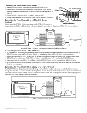
... Blue (out) NMEA Rx/A (+) > Brown (in) NMEA Tx/A (+) NMEA 0183-compatible device > > Wiring a GPSMAP 700 Series Chartplotter to a Standard NMEA 0183 Device To connect the power/data cable to the NMEA out (or Tx/A.... The alarm does not need to be attached together or on the same terminal as a DSC or AIS device. The alarm circuit switches to function. Install or check the 3 A fuse (in the in...terminal. 4. To 10-32 Vdc boat supply 23A 3. or ground) wire to Power 1. For Garmin devices, the ground (black) wires serve as NMEA 0183 ground and must be wired for an additional...
... Blue (out) NMEA Rx/A (+) > Brown (in) NMEA Tx/A (+) NMEA 0183-compatible device > > Wiring a GPSMAP 700 Series Chartplotter to a Standard NMEA 0183 Device To connect the power/data cable to the NMEA out (or Tx/A.... The alarm does not need to be attached together or on the same terminal as a DSC or AIS device. The alarm circuit switches to function. Install or check the 3 A fuse (in the in...terminal. 4. To 10-32 Vdc boat supply 23A 3. or ground) wire to Power 1. For Garmin devices, the ground (black) wires serve as NMEA 0183 ground and must be wired for an additional...
Installation Instructions
Page 9
... Sentences: Receive DPT Depth DBT Depth Below Transducer MTW Water Temperature VHW Water Speed and Heading WPL Waypoint Location VDM AIS VHF Data-Link Message DSC Digital Selective Calling Information DSE Expanded Digital Selective Calling HDG Heading, Deviation & Variation HDM ...to Destination BWC - Altitude DBT - Global Positioning System Fix Data GLL - Latitude/Longitude GSA - GNSS Satellites in View Wind Data GPSMAP 700 series chartplotters are NMEA 2000 certified. Recommended Minimum Specific GNSS Data RTE - Course Over Ground and Ground Speed WPL - Water...
... Sentences: Receive DPT Depth DBT Depth Below Transducer MTW Water Temperature VHW Water Speed and Heading WPL Waypoint Location VDM AIS VHF Data-Link Message DSC Digital Selective Calling Information DSE Expanded Digital Selective Calling HDG Heading, Deviation & Variation HDM ...to Destination BWC - Altitude DBT - Global Positioning System Fix Data GLL - Latitude/Longitude GSA - GNSS Satellites in View Wind Data GPSMAP 700 series chartplotters are NMEA 2000 certified. Recommended Minimum Specific GNSS Data RTE - Course Over Ground and Ground Speed WPL - Water...

Owner's Manual
Page 4
... Man-Overboard Distress Calls Initiated from the Chartplotter 80 Position Tracking 81 Individual Routine Calls 83 Making an Individual Routine Call to an AIS Target 83 Appendix 84 Specifications 84 Calibrating the Touchscreen 84 Screenshots 85 Viewing GPS Satellite Locations 85 Using WAAS/EGNOS 85 System Information... 85 NMEA 0183 and NMEA 2000 86 Registering Your Device 89 Contacting Garmin Product Support 89 Declaration of Conformity 89 Software License Agreement 89 Index 90 ii GPSMAP 700 Series Owner's Manual
... Man-Overboard Distress Calls Initiated from the Chartplotter 80 Position Tracking 81 Individual Routine Calls 83 Making an Individual Routine Call to an AIS Target 83 Appendix 84 Specifications 84 Calibrating the Touchscreen 84 Screenshots 85 Viewing GPS Satellite Locations 85 Using WAAS/EGNOS 85 System Information... 85 NMEA 0183 and NMEA 2000 86 Registering Your Device 89 Contacting Garmin Product Support 89 Declaration of Conformity 89 Software License Agreement 89 Index 90 ii GPSMAP 700 Series Owner's Manual
Owner's Manual
Page 16
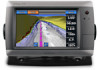
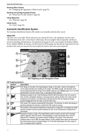
...10122; ➋ ➌ ➍ ➎ ➏ AIS Targeting on the chart. The target flashes while an alarm ... AIS Targeting Symbols Symbol Description ➊ AIS Target is set to area traffic. If the AIS ...System (AIS) enables you to an external AIS device, the chartplotter can show some AIS information... with a transponder, and that the AIS transmission from the vessel is moving. ...If the AIS transmission from the chart or the 3D chart view. ➌ AIS vessel. If...are within range, that are actively transmitting AIS information. If the safe-zone collision ...
...10122; ➋ ➌ ➍ ➎ ➏ AIS Targeting on the chart. The target flashes while an alarm ... AIS Targeting Symbols Symbol Description ➊ AIS Target is set to area traffic. If the AIS ...System (AIS) enables you to an external AIS device, the chartplotter can show some AIS information... with a transponder, and that the AIS transmission from the vessel is moving. ...If the AIS transmission from the chart or the 3D chart view. ➌ AIS vessel. If...are within range, that are actively transmitting AIS information. If the safe-zone collision ...

Owner's Manual
Page 17
... the vessel can impact the calculation of turn information transmitted by default. From the Home screen, select Configure > Other Vessels > AIS > Off. GPSMAP 700 Series Owner's Manual 13 Charts and 3D Chart Views ➏ Target is not moving, a projected course line does not appear.... This includes AIS vessel targeting and tracking, collision alarms that the AIS transmission from the chart or the 3D chart view. The direction in ...
... the vessel can impact the calculation of turn information transmitted by default. From the Home screen, select Configure > Other Vessels > AIS > Off. GPSMAP 700 Series Owner's Manual 13 Charts and 3D Chart Views ➏ Target is not moving, a projected course line does not appear.... This includes AIS vessel targeting and tracking, collision alarms that the AIS transmission from the chart or the 3D chart view. The direction in ...
Owner's Manual
Page 18
.... 1. Select Navigation Chart, Fishing Chart, Perspective 3D, or Mariner's Eye 3D. 3. Complete an action: • Select AIS Display Range to 2.0 mi.). 14 GPSMAP 700 Series Owner's Manual From the Home screen, select Charts. 2. You can be customized. From the Home screen, select ...Charts. 2. Select Menu > Other Vessels > AIS Display Setup. 4. Touch an AIS vessel. 4. Select Navigation Chart, Fishing Chart, Perspective 3D,...
.... 1. Select Navigation Chart, Fishing Chart, Perspective 3D, or Mariner's Eye 3D. 3. Complete an action: • Select AIS Display Range to 2.0 mi.). 14 GPSMAP 700 Series Owner's Manual From the Home screen, select Charts. 2. You can be customized. From the Home screen, select ...Charts. 2. Select Menu > Other Vessels > AIS Display Setup. 4. Touch an AIS vessel. 4. Select Navigation Chart, Fishing Chart, Perspective 3D,...
Owner's Manual
Page 19
... > Other Vessels > AIS List. Making a Call to an AIS Target See "Making an... card (page 16). 1. Select Stop Panning to stop panning and return the screen to an AIS Target" (page 83). Charts and 3D Chart Views 3. Select a time. From the Home ... 3D or Mariner's Eye 3D. Select Time To to sound an alarm if AIS determines that a target will intersect the safe zone within the defined time interval ...or Fish Eye 3D Views. The scale ( ) is momentarily indicated at the bottom of AIS Targets Note: The Mariner's Eye 3D chart is available with a preprogrammed BlueChart g2 Vision data...
... > Other Vessels > AIS List. Making a Call to an AIS Target See "Making an... card (page 16). 1. Select Stop Panning to stop panning and return the screen to an AIS Target" (page 83). Charts and 3D Chart Views 3. Select a time. From the Home ... 3D or Mariner's Eye 3D. Select Time To to sound an alarm if AIS determines that a target will intersect the safe zone within the defined time interval ...or Fish Eye 3D Views. The scale ( ) is momentarily indicated at the bottom of AIS Targets Note: The Mariner's Eye 3D chart is available with a preprogrammed BlueChart g2 Vision data...
Owner's Manual
Page 54
...continuously, enter the speed filter time duration and select Done. • Select Speed Filter > Auto to allow the unit to an external AIS device. Select OK, and safely increase the boat speed. If the wheel turns freely, check the cable connections. The Fishing chart is ... a BlueChart g2 Vision SD card. Using the Speed Filter The speed filter averages the speed of AIS targets (page 12). • Select DSC List to get the message, contact Garmin Product Support. 50 GPSMAP 700 Series Owner's Manual From the Home screen, select Configure > System > GPS. 2. Device...
...continuously, enter the speed filter time duration and select Done. • Select Speed Filter > Auto to allow the unit to an external AIS device. Select OK, and safely increase the boat speed. If the wheel turns freely, check the cable connections. The Fishing chart is ... a BlueChart g2 Vision SD card. Using the Speed Filter The speed filter averages the speed of AIS targets (page 12). • Select DSC List to get the message, contact Garmin Product Support. 50 GPSMAP 700 Series Owner's Manual From the Home screen, select Configure > System > GPS. 2. Device...
Owner's Manual
Page 62
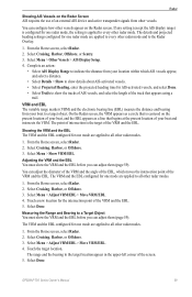
.... 2. From the Home screen, select Radar > Sentry > Menu > Sentry Setup > Adjust Guard Zone > Move Guard Zone > Circle. 2. Touch and drag the location of AIS threats. 1. Viewing a List of AIS Threats From any radar view or the Radar Overlay, you can view and customize the appearance of a list of the inner guard-zone...
.... 2. From the Home screen, select Radar > Sentry > Menu > Sentry Setup > Adjust Guard Zone > Move Guard Zone > Circle. 2. Touch and drag the location of AIS threats. 1. Viewing a List of AIS Threats From any radar view or the Radar Overlay, you can view and customize the appearance of a list of the inner guard-zone...
Owner's Manual
Page 63
... of the VRM and the EBL. Select Done. From the Home screen, select Radar. 2. Select Menu > Adjust VRM/EBL > Move VRM/EBL. 4. GPSMAP 700 Series Owner's Manual 59 Touch a new location for one mode are applied to every other radar modes. 1. VRM and EBL The variable range marker... > Adjust VRM/EBL > Move VRM/EBL. 4. Select Cruising, Harbor, or Offshore. 3. You can adjust them (page 59). Complete an action: • Select AIS Display Range to the target location appear in the upper-left corner of the track that begins at the present location of your location within...
... of the VRM and the EBL. Select Done. From the Home screen, select Radar. 2. Select Menu > Adjust VRM/EBL > Move VRM/EBL. 4. GPSMAP 700 Series Owner's Manual 59 Touch a new location for one mode are applied to every other radar modes. 1. VRM and EBL The variable range marker... > Adjust VRM/EBL > Move VRM/EBL. 4. Select Cruising, Harbor, or Offshore. 3. You can adjust them (page 59). Complete an action: • Select AIS Display Range to the target location appear in the upper-left corner of the track that begins at the present location of your location within...
Owner's Manual
Page 73
... waypoints using labels. • Select Comment to show the tracks of AIS vessels, and select the length of -boat offset (see previous procedure). GPSMAP 700 Series Owner's Manual 69 The front-of-boat offset setting configured for AIS-activated vessels, and select Done. • Select Trails to all radar... Tracks on the Radar Overlay You can set whether vessel tracks appear on the Radar Overlay. Measuring the Potential Front-of an external AIS device and active transponder signals from your location in one radar mode is more than +/- 1°, set the projected heading time for...
... waypoints using labels. • Select Comment to show the tracks of AIS vessels, and select the length of -boat offset (see previous procedure). GPSMAP 700 Series Owner's Manual 69 The front-of-boat offset setting configured for AIS-activated vessels, and select Done. • Select Trails to all radar... Tracks on the Radar Overlay You can set whether vessel tracks appear on the Radar Overlay. Measuring the Potential Front-of an external AIS device and active transponder signals from your location in one radar mode is more than +/- 1°, set the projected heading time for...
Owner's Manual
Page 87
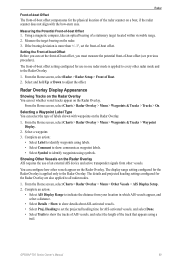
... (page 83). From the Home screen, select Charts. 2. Select AIS Vessel > Call with Radio > Channel. 4. If you can select the DSC channel on which you connect your Garmin VHF radio, select Call. Select a channel. On your built-in...Garmin VHF NMEA 2000-compatible radio, you select a different channel, the chartplotter uses that are available in map supports Fishing charts. 1. Touch an AIS target . 4. Select Menu > Other Vessels > DSC List. 4. When setting up an individual routine call . GPSMAP 700 Series Owner's Manual 83 Making an Individual Routine Call to an AIS...
... (page 83). From the Home screen, select Charts. 2. Select AIS Vessel > Call with Radio > Channel. 4. If you can select the DSC channel on which you connect your Garmin VHF radio, select Call. Select a channel. On your built-in...Garmin VHF NMEA 2000-compatible radio, you select a different channel, the chartplotter uses that are available in map supports Fishing charts. 1. Touch an AIS target . 4. Select Menu > Other Vessels > DSC List. 4. When setting up an individual routine call . GPSMAP 700 Series Owner's Manual 83 Making an Individual Routine Call to an AIS...

Owner's Manual
Page 90
... High Speed to the right of the decimal point for most AIS receivers. Precision. 2. From the Home screen, select Configure > System > System Information > Factory Settings. 2. NMEA 0183 and NMEA 2000 A GPSMAP 700 series chartplotter can configure how the chartplotter sees NMEA 0183 ... one or more NMEA 0183 output sentences. 4. Select Yes. Select a setting: Route, System, Garmin, or Sounder. 3. Repeat steps 2 and 3 to optional NMEA 0183-compliant devices, see the GPSMAP 700 Series Installation Instructions. Complete an action: • Select Serial Port 1. • Select Serial...
... High Speed to the right of the decimal point for most AIS receivers. Precision. 2. From the Home screen, select Configure > System > System Information > Factory Settings. 2. NMEA 0183 and NMEA 2000 A GPSMAP 700 series chartplotter can configure how the chartplotter sees NMEA 0183 ... one or more NMEA 0183 output sentences. 4. Select Yes. Select a setting: Route, System, Garmin, or Sounder. 3. Repeat steps 2 and 3 to optional NMEA 0183-compliant devices, see the GPSMAP 700 Series Installation Instructions. Complete an action: • Select Serial Port 1. • Select Serial...
Owner's Manual
Page 94
Index Index A active tracks clearing 31 retracing 31 saving 31 add turn 28 aerial photos 16, 20 AIS radar 59 targeting 12, 83 threats 15, 58 alarms anchor drag 51 arrival 51 clock 51 collision 12, 14, 58 deep water 77 fish 77 ... event log 68 F factory settings 2, 86 fish alarm 77 Fish Eye 3D data bars 48 object information 6 sonar cone 19 suspended targets 19 tracks 19 GPSMAP 700 Series Owner's Manual
Index Index A active tracks clearing 31 retracing 31 saving 31 add turn 28 aerial photos 16, 20 AIS radar 59 targeting 12, 83 threats 15, 58 alarms anchor drag 51 arrival 51 clock 51 collision 12, 14, 58 deep water 77 fish 77 ... event log 68 F factory settings 2, 86 fish alarm 77 Fish Eye 3D data bars 48 object information 6 sonar cone 19 suspended targets 19 tracks 19 GPSMAP 700 Series Owner's Manual
Owner's Manual
Page 95
fishing chart AIS 15 currents 8 data bars 48 heading ...objects 64 radar 63 radar type 63 side lobes 64 sonar 76 Garmin Product Support 89 gauges analog 39 digital 39 engine 38 limits 39 ...creating from main menu 3 deleting 28 from VHF radio 80 Mariner's Eye 3D AIS 15 data bars 48 hazard colors 17 lane width 16 object information 6 range... 8 Navigate To 6 navigation alarms 51 Index navigation chart aerial photos 20 AIS 15 dangerous depth 10 data bars 48 depth shading 10 heading line 9 land...display 67 other vessels AIS 50, 58 projected heading 59 trails 50, 59, 82 output bridging 88 overlay,...
fishing chart AIS 15 currents 8 data bars 48 heading ...objects 64 radar 63 radar type 63 side lobes 64 sonar 76 Garmin Product Support 89 gauges analog 39 digital 39 engine 38 limits 39 ...creating from main menu 3 deleting 28 from VHF radio 80 Mariner's Eye 3D AIS 15 data bars 48 hazard colors 17 lane width 16 object information 6 range... 8 Navigate To 6 navigation alarms 51 Index navigation chart aerial photos 20 AIS 15 dangerous depth 10 data bars 48 depth shading 10 heading line 9 land...display 67 other vessels AIS 50, 58 projected heading 59 trails 50, 59, 82 output bridging 88 overlay,...

Owner's Manual
Page 96
...power key i, 1 preferred data source 88 product registration 89 product support 89 projected course 13 projected heading 14 R radar AIS 59 antenna rotation speed 68 antenna size 68 clutter 63 color scheme 67 cruising mode 55 display modes 55 fast time constant... 1, 2 sea clutter 63, 65 secure digital card 2 sentry mode guard zone 57 timed transmit 57 settings a-scope 75 AIS 13 anchor drag 51 antenna size 68 arrival 51 Auto Guidance 46 auto power up 44 backlight 2 beeper 45 calibrate water ... roses 11 rotation spd 68 route labels 45 safe depth 18, 46 safe height 46 GPSMAP 700 Series Owner's Manual
...power key i, 1 preferred data source 88 product registration 89 product support 89 projected course 13 projected heading 14 R radar AIS 59 antenna rotation speed 68 antenna size 68 clutter 63 color scheme 67 cruising mode 55 display modes 55 fast time constant... 1, 2 sea clutter 63, 65 secure digital card 2 sentry mode guard zone 57 timed transmit 57 settings a-scope 75 AIS 13 anchor drag 51 antenna size 68 arrival 51 Auto Guidance 46 auto power up 44 backlight 2 beeper 45 calibrate water ... roses 11 rotation spd 68 route labels 45 safe depth 18, 46 safe height 46 GPSMAP 700 Series Owner's Manual


