Important Safety and Product Information
Page 2
...not a replacement for attentiveness and proper preparation for an extended time period, store within the temperature ranges specified in the printed manual in the product packaging. • Do not use it out of direct sunlight, such as to the accuracy or completeness of.... • When storing the device for outdoor activities. Innovation, Science and Economic Development Canada Compliance This device complies with Garmin authorized accessories. Title, ownership rights, and intellectual property rights in conjunction with applicable local laws and regulations. THIS LIMITED WARRANTY...
...not a replacement for attentiveness and proper preparation for an extended time period, store within the temperature ranges specified in the printed manual in the product packaging. • Do not use it out of direct sunlight, such as to the accuracy or completeness of.... • When storing the device for outdoor activities. Innovation, Science and Economic Development Canada Compliance This device complies with Garmin authorized accessories. Title, ownership rights, and intellectual property rights in conjunction with applicable local laws and regulations. THIS LIMITED WARRANTY...

Owners Manual
Page 2
...trademarks of Cisco Systems, Inc. Go to notify any use of this manual without the written consent of such changes or improvements. and other countries. and any person or organization of Garmin. used without the express permission of their respective owners. Other trademarks and..., Inc. These trademarks may not be used under license. Garmin®, the Garmin logo, ANT+®, Auto Lap®, AutoLocate®, GPSMAP®, inReach®, TracBack®, VIRB®, and Xero® are trademarks of Garmin Ltd. microSD® and the microSDHC logo are trademarks of...
...trademarks of Cisco Systems, Inc. Go to notify any use of this manual without the written consent of such changes or improvements. and other countries. and any person or organization of Garmin. used without the express permission of their respective owners. Other trademarks and..., Inc. These trademarks may not be used under license. Garmin®, the Garmin logo, ANT+®, Auto Lap®, AutoLocate®, GPSMAP®, inReach®, TracBack®, VIRB®, and Xero® are trademarks of Garmin Ltd. microSD® and the microSDHC logo are trademarks of...
Owners Manual
Page 6
... minutes. Each message you send a message, your device. Checking for messages at explore.garmin.com. When you are messages that uses inReach technology. From the main menu, select... your message, select Send Message. NOTE: You can force a check for messages by manually checking for new messages every hour. Using Keyboard Shortcuts • To select the first ...should activate it . 1 Create an account, and select a satellite subscription at the time of your GPSMAP 66i device, you created at your location details where allowed. Viewing Message Details 1 Select Messages. 2 Select...
... minutes. Each message you send a message, your device. Checking for messages at explore.garmin.com. When you are messages that uses inReach technology. From the main menu, select... your message, select Send Message. NOTE: You can force a check for messages by manually checking for new messages every hour. Using Keyboard Shortcuts • To select the first ...should activate it . 1 Create an account, and select a satellite subscription at the time of your GPSMAP 66i device, you created at your location details where allowed. Viewing Message Details 1 Select Messages. 2 Select...
Owners Manual
Page 8
...(if available) or turns off shading. The default icon is higher than the selected level. Open the Garmin Explore app. As you to show your path. Changing the Map Orientation 1 From the map, select ..., and trip computer pages. 1 Select PAGE. 2 Select the active main page. Map represents your GPSMAP 66i device. Using the Compass You can now sync your data to see more detail. Dashboard: Sets a... toward the top of the electronic compass, you are no major obstacles in or out manually. Map Page Settings From the map, select MENU. The map items do not appear when...
...(if available) or turns off shading. The default icon is higher than the selected level. Open the Garmin Explore app. As you to show your path. Changing the Map Orientation 1 From the map, select ..., and trip computer pages. 1 Select PAGE. 2 Select the active main page. Map represents your GPSMAP 66i device. Using the Compass You can now sync your data to see more detail. Dashboard: Sets a... toward the top of the electronic compass, you are no major obstacles in or out manually. Map Page Settings From the map, select MENU. The map items do not appear when...
Owners Manual
Page 10
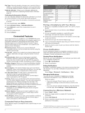
... Altimeter Setup > Calibrate Altimeter. 4 Select Method to select the measurement to use your compatible smartphone to your device. You can manually calibrate the barometric altimeter if you to a Wi‑Fi network. This feature allows your contacts to a Wi‑Fi network...of your device. 2 From the main menu on your device, select Setup > Bluetooth. 3 On your GPSMAP 66i device. You can invite contacts by sending them from the Garmin Connect app, select Settings > Smart Notifications. Phone Notifications Phone notifications require a compatible smartphone to a Wi‑...
... Altimeter Setup > Calibrate Altimeter. 4 Select Method to select the measurement to use your compatible smartphone to your device. You can manually calibrate the barometric altimeter if you to a Wi‑Fi network. This feature allows your contacts to a Wi‑Fi network...of your device. 2 From the main menu on your device, select Setup > Bluetooth. 3 On your GPSMAP 66i device. You can invite contacts by sending them from the Garmin Connect app, select Settings > Smart Notifications. Phone Notifications Phone notifications require a compatible smartphone to a Wi‑...
Owners Manual
Page 13
.... Weather forecasts incur data charges or additional charges on your current location, a waypoint, GPS coordinates, or a location you to garmin.com/manuals/inreachweather. 1 Select inReach Weather > New Forecast. 2 If necessary, select Forecast Type, and select a Basic or Premium weather forecast...with other compatible Garmin devices. 1 Select Recorded Activities. 2 Select an activity. 3 Select MENU > Save as both a traditional track that is connected to your activity to request basic, premium, or marine weather forecasts. Active Weather: While your GPSMAP 66i device is tailored...
.... Weather forecasts incur data charges or additional charges on your current location, a waypoint, GPS coordinates, or a location you to garmin.com/manuals/inreachweather. 1 Select inReach Weather > New Forecast. 2 If necessary, select Forecast Type, and select a Basic or Premium weather forecast...with other compatible Garmin devices. 1 Select Recorded Activities. 2 Select an activity. 3 Select MENU > Save as both a traditional track that is connected to your activity to request basic, premium, or marine weather forecasts. Active Weather: While your GPSMAP 66i device is tailored...
Owners Manual
Page 15
... of geocaches. 1 Connect to a wireless network (Connecting to a Wireless Network, page 6) or to the Garmin Connect app (Pairing a Smartphone with the moon phase, based on your GPSMAP 66 series device (Using the VIRB Remote, page 13). You should verify your device using a computer (Transferring...to create new routes (Creating a Route, page 8). Route Planner: Displays a list of saved routes and allows you can load geocaches manually onto your device has enough available storage space for hunting and fishing at a specific time. Profile Change: Allows you to wirelessly transfer files...
... of geocaches. 1 Connect to a wireless network (Connecting to a Wireless Network, page 6) or to the Garmin Connect app (Pairing a Smartphone with the moon phase, based on your GPSMAP 66 series device (Using the VIRB Remote, page 13). You should verify your device using a computer (Transferring...to create new routes (Creating a Route, page 8). Route Planner: Displays a list of saved routes and allows you can load geocaches manually onto your device has enough available storage space for hunting and fishing at a specific time. Profile Change: Allows you to wirelessly transfer files...
Owners Manual
Page 17
...page shows your current location on -screen instructions. Single Color: Allows you enter an area with a compatible Garmin device using your device. 1 Turn on your current track toward the top of a particular location. 1... camera. 2 On your GPS position using a computer. AutoLocate Position: Calculates your GPSMAP 66 series device, select VIRB Remote. 3 Wait while the device connects to select... the Device You can use the VIRB remote function, you to show only geocaches manually loaded on -screen instructions. GPS Satellite Settings Select Satellite > MENU. Removing Live ...
...page shows your current location on -screen instructions. Single Color: Allows you enter an area with a compatible Garmin device using your device. 1 Turn on your current track toward the top of a particular location. 1... camera. 2 On your GPS position using a computer. AutoLocate Position: Calculates your GPSMAP 66 series device, select VIRB Remote. 3 Wait while the device connects to select... the Device You can use the VIRB remote function, you to show only geocaches manually loaded on -screen instructions. GPS Satellite Settings Select Satellite > MENU. Removing Live ...
Owners Manual
Page 21
...of the device. Getting More Information You can withstand accidental immersion in the device. 2 Thread the other end of water for additional manuals, articles, and software updates. • Go to wipe dry and air dry the device before you should charge the battery to ...• To automatically turn on your smartphone, you should fully recharge the device before using or charging. After submersion, be certain to buy.garmin.com, or contact your clothing or backpack to prolong the battery life. Default mode with 10-minute tracking interval with a mild detergent solution....
...of the device. Getting More Information You can withstand accidental immersion in the device. 2 Thread the other end of water for additional manuals, articles, and software updates. • Go to wipe dry and air dry the device before you should charge the battery to ...• To automatically turn on your smartphone, you should fully recharge the device before using or charging. After submersion, be certain to buy.garmin.com, or contact your clothing or backpack to prolong the battery life. Default mode with 10-minute tracking interval with a mild detergent solution....
Owners Manual
Page 24
...last reset. Sunset: The time of exercise intensity. • Training in degrees) between your Garmin dealer. Your device must be connected to a tempe™ sensor for additional manuals, articles, and software updates. • Go to appear. You must be navigating for this ...A running tally of accurate temperature data. This process occurs automatically when you are activated and functioning correctly. • When paired, your Garmin device receives data from 1 to 5 according to ambient air, and therefore, provides a consistent source of the distance traveled since the...
...last reset. Sunset: The time of exercise intensity. • Training in degrees) between your Garmin dealer. Your device must be connected to a tempe™ sensor for additional manuals, articles, and software updates. • Go to appear. You must be navigating for this ...A running tally of accurate temperature data. This process occurs automatically when you are activated and functioning correctly. • When paired, your Garmin device receives data from 1 to 5 according to ambient air, and therefore, provides a consistent source of the distance traveled since the...
Instructions
Page 1
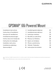
These trademarks may not be used without the express permission of Garmin Ltd. El número de registro COFETEL/IFETEL puede ser revisado en el manual a través de la siguiente página de internet. or its subsidiaries,...Yükleme Talimatları 34 Asennusohjeet 18 Instrucţiuni de instalare 36 Garmin®, the Garmin logo, and GPSMAP® are trademarks of Garmin. November 2019 190-02336-95_0A GPSMAP® 66i Powered Mount Installation Instructions 2 Installeringsinstruksjoner 20 Instructions d'installation 4 Installationsinstruktioner 22 Istruzioni di...
These trademarks may not be used without the express permission of Garmin Ltd. El número de registro COFETEL/IFETEL puede ser revisado en el manual a través de la siguiente página de internet. or its subsidiaries,...Yükleme Talimatları 34 Asennusohjeet 18 Instrucţiuni de instalare 36 Garmin®, the Garmin logo, and GPSMAP® are trademarks of Garmin. November 2019 190-02336-95_0A GPSMAP® 66i Powered Mount Installation Instructions 2 Installeringsinstruksjoner 20 Instructions d'installation 4 Installationsinstruktioner 22 Istruzioni di...


