Installation Instructions
Page 1
... your chartplotter. Mount the chartplotter (page 2). 3. Install the transducer, if applicable (page 3). 4. Chartplotter GPSMAP 420/430/430x/440/440x/450 GPSMAP 520/525/530/535/540/545/550/555 GPSMAP 421/441/451 GPSMAP 431/531 GPSMAP 521/526/536/541/546/551/556 NMEA 2000 No No Yes No Yes NMEA 0183 Yes Yes Yes Yes Yes Garmin CANet...
... your chartplotter. Mount the chartplotter (page 2). 3. Install the transducer, if applicable (page 3). 4. Chartplotter GPSMAP 420/430/430x/440/440x/450 GPSMAP 520/525/530/535/540/545/550/555 GPSMAP 421/441/451 GPSMAP 431/531 GPSMAP 521/526/536/541/546/551/556 NMEA 2000 No No Yes No Yes NMEA 0183 Yes Yes Yes Yes Yes Garmin CANet...
Installation Instructions
Page 9
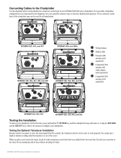
...chartplotter may not be in the water, check for leaks. Testing the Optional Transducer Installation Because water is necessary to carry the sonar signal from the sounder, the transducer must be used for all installations. ➋ ➌ ➌ ➊➎ GPSMAP 421, 441, and 451 ➌ ➊ GPSMAP... 430x and 440x ➍ ➊ GPSMAP 420, 430, 431, 440, and 450 ➋ ➌ GPSMAP 530, 535, 540, and 545 ➋➊ ➊ Wiring ...
...chartplotter may not be in the water, check for leaks. Testing the Optional Transducer Installation Because water is necessary to carry the sonar signal from the sounder, the transducer must be used for all installations. ➋ ➌ ➌ ➊➎ GPSMAP 421, 441, and 451 ➌ ➊ GPSMAP... 430x and 440x ➍ ➊ GPSMAP 420, 430, 431, 440, and 450 ➋ ➌ GPSMAP 530, 535, 540, and 545 ➋➊ ➊ Wiring ...
Owner's Manual
Page 13
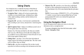
...and as a three-dimensional navigation aid. Note: If you are available if you use a BlueChart g2 Vision SD card. Fishing charts are using a GPSMAP 421, 521, or 526 (including "s" models), you use a BlueChart g2 Vision SD card or if your course), and provides a visual navigation aid. ... aid. Using Charts • Mariner's Eye 3D-provides a view from the Home screen, select Charts > Navigation Chart. Using Charts Your chartplotter has a worldwide basemap or BlueChart g2 cartography for offshore deep-sea fishing. • Fish Eye 3D-provides an underwater 3D view that visually...
...and as a three-dimensional navigation aid. Note: If you are available if you use a BlueChart g2 Vision SD card. Fishing charts are using a GPSMAP 421, 521, or 526 (including "s" models), you use a BlueChart g2 Vision SD card or if your course), and provides a visual navigation aid. ... aid. Using Charts • Mariner's Eye 3D-provides a view from the Home screen, select Charts > Navigation Chart. Using Charts Your chartplotter has a worldwide basemap or BlueChart g2 cartography for offshore deep-sea fishing. • Fish Eye 3D-provides an underwater 3D view that visually...
Owner's Manual
Page 62
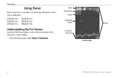
Using Sonar Using Sonar When connected to a transducer, the following chartplotters can be used as fishfinders: GPSMAP 421s GPSMAP 451s GPSMAP 521s GPSMAP 526s GPSMAP 551s GPSMAP 556s Understanding the Full Screen Select the Full Screen option to view a full-screen graph of the transducer's sonar readings. From the Home screen, select Sonar > Full Screen. Depth Temperature Speed Suspended targets Transducer frequency Full Screen Range 56 GPSMAP 400/500 Series Owner's Manual
Using Sonar Using Sonar When connected to a transducer, the following chartplotters can be used as fishfinders: GPSMAP 421s GPSMAP 451s GPSMAP 521s GPSMAP 526s GPSMAP 551s GPSMAP 556s Understanding the Full Screen Select the Full Screen option to view a full-screen graph of the transducer's sonar readings. From the Home screen, select Sonar > Full Screen. Depth Temperature Speed Suspended targets Transducer frequency Full Screen Range 56 GPSMAP 400/500 Series Owner's Manual
Owner's Manual
Page 78
..., organization, and code of the Software are valuable trade secrets of Garmin and that the Software is the property of Garmin and is displayed. NMEA 2000 The following GPSMAP 400 and GPSMAP 500 series chartplotters are NMEA 2000 certified and can receive data from a NMEA 2000 ...You acknowledge that the Software in source code form remains a valuable trade secret of Garmin. GPSMAP 421/421s GPSMAP 451/451s GPSMAP 551/551s GPSMAP 521/521s GPSMAP 526/526s GPSMAP 556/556s To connect one of these chartplotter to an existing NMEA 2000 network and to any derivative works based on the ...
..., organization, and code of the Software are valuable trade secrets of Garmin and that the Software is the property of Garmin and is displayed. NMEA 2000 The following GPSMAP 400 and GPSMAP 500 series chartplotters are NMEA 2000 certified and can receive data from a NMEA 2000 ...You acknowledge that the Software in source code form remains a valuable trade secret of Garmin. GPSMAP 421/421s GPSMAP 451/451s GPSMAP 551/551s GPSMAP 521/521s GPSMAP 526/526s GPSMAP 556/556s To connect one of these chartplotter to an existing NMEA 2000 network and to any derivative works based on the ...


