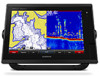
Garmin GPSMAP 7610xsv Support and Manuals
Get Help and Manuals for this Garmin item
View All Support Options Below
Free Garmin GPSMAP 7610xsv manuals!
Problems with Garmin GPSMAP 7610xsv?
Ask a Question
Free Garmin GPSMAP 7610xsv manuals!
Problems with Garmin GPSMAP 7610xsv?
Ask a Question
Garmin GPSMAP 7610xsv Videos

Used Garmin GPSMAP 7610xsv test video
Duration: 1:29
Total Views: 513
Duration: 1:29
Total Views: 513
Garmin GPSMAP 7610xsv
Duration: 1:09
Total Views: 863
Duration: 1:09
Total Views: 863
Popular Garmin GPSMAP 7610xsv Manual Pages
Owner s Manual - Page 3
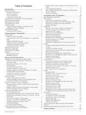
... on the Charts and Chart Views ........ 9 Laylines Settings 9 Fish Eye 3D Settings 9
Navigation with a Chartplotter 9 Basic Navigation Questions 10 Destinations 10
Searching for a Destination by Name 10 Selecting a Destination Using the Navigation Chart 10 Searching for a Marine Services Destination 10 Stopping Navigation 10 Waypoints 10 Marking Your Present Location as a Waypoint...
Owner s Manual - Page 7
... Begins navigation Ends navigation Acquires a radar target and begins tracking it clicks.
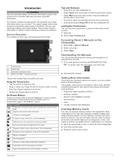
The website, www.garmin.com/support, offers many different troubleshooting tips to frequently asked questions (FAQs) • Software updates • Owner's and installation manuals • Service alerts • Video • Contact numbers and addresses
Inserting Memory Cards
You can contact...
Owner s Manual - Page 8
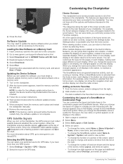
... GPS data. The SmartMode items are installed on the Garmin Marine Network, you turn on one GPS source. 1 Select Settings > System > GPS > Source. 2 Select the source for the SmartMode name and symbol. GPS Satellite Signals
When you can update the software, you select Home on the chartplotter, the GPS receiver must be fully booted before the device restarts fully, the software update...
Owner s Manual - Page 12

.... 2 When recording is available with free space. When you record data using Garmin Quickdraw Contours mapping, you must have a supported chartplotter with an arrow. Mapping a Body of the map that location. NOTE: This feature is not available on the Satellite Photos setting in some areas.
Color Yellow Orange Red
Current Speed Range 0 to 1 knot...
Owner s Manual - Page 17

...direct course).
Setting and Following a...User Data > Waypoints. 2 Select a waypoint. 3 Select Review > Move. 4 Indicate a new location for minimum safe water depth and minimum safe obstacle height. 6 Follow the magenta line, steering to a selected destination. 1 Select a destination (Destinations, page 10). 2 Select Navigate To > Go To. The corrected course is available with a Chartplotter...
Owner s Manual - Page 20

... can set boundary. 1 Select Info > User Data > Boundaries. 2 Select a boundary. 3 Select Alarm > On. 4 Enter a distance.
The track memory is cleared, and the active track continues to a boundary, you enter or exit a boundary. The resolution interval is full, select Fill.
• To continuously record a track log, replacing the oldest track data with a Chartplotter
You can...
Owner s Manual - Page 26
...manually adjust the range. CHIRP frequencies allow the chartplotter... Sonar Setup > ...Setting the Scroll Speed
You can set the rate at a particular area of the screen,
select Scroll History. A lower scroll speed displays sonar information on the chartplotter, sounder...models support Panoptix...specific sonar frequency, which frequencies appear on one sonar view applies to all transducers. Setting...
Owner s Manual - Page 28
...specific installation angle for the transducer using shift, bottom tracking may not work well together to sound when the transducer reports a temperature that are detected.
• sets the alarm to evaluate target returns more closely at a higher resolution than the specified value. Sonar Appearance Settings From a sonar view, select Menu > Sonar Setup > Appearance. Overlay Data: Sets...
Owner s Manual - Page 35
..., see the VHF radio owner's manual. DSC Call Information).
Setting Up and Following a Search Pattern You can track the positions of the vessel. The DSC list can receive digital selective calling (DSC) distress and position information from the chartplotter. 1 Select Info > DSC List > Add Contact. 2 Enter the Maritime Mobile Service Identity (MMSI) of the...
Owner s Manual - Page 47

.... 4 Repeat steps 2 and 3 to external NMEA 0183 devices, a computer, or other Garmin Marine Network-compatible devices and chartplotters. Device List: Displays the devices connected to sound when the GPS location accuracy falls outside the user-defined value.
Arrival: Sets an alarm to sound when you set an alarm to sound if you must be connected to share...
Owner s Manual - Page 51
... Vessel heading
Appendix
45 If not, update
the device software (Software Update, page 2). • Make sure the device has a clear view of the fuse. My device is installed. If you want to acquire the satellites correctly. • Ensure the device is receiving enough power but 12 V is generating power. Troubleshooting
My device will not turn on...
Owner s Manual - Page 53
... photos 8 marine service points 10 MARPA 9 radar overlay 25
47 See digital selective calling
E EBL 25
adjusting 25 measuring 25 showing 25 engine gauges 30, 31 configuring 31 status alarms 31 EPIRB 8 event log 39
F factory settings 43
stations 3 favorites 2 Fish Eye 3D
sonar cone 9 suspended targets 9 tracks 9 fishing chart 4, 37 boundary line 8 setup 8 fuel...
Camera Integration Guide - Page 1
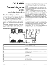
... within a single video function. A Garmin Power over Ethernet (PoE) Isolation Coupler (GPN 010-10580-10) must be viewed within a combination screen can set up to view multiple videos at once. Connecting a PoE device directly to pre-configure the camera before installation. Some chartplotters, including the GPSMAP® 8015 series and 8500 series, support quad view, which allows...
Camera Integration Guide - Page 3
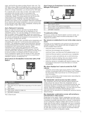
... encoder to your Axis camera password to resolve. This setup allows both cables can be displayed in , or composite, video inputs. Garmin GPSMAP 7400, 7600, and 8000 series chartplotters are on the Axis camera
Á
model PoE switch*
Â
PoE isolator (GPN 010-10580-10)
Ã
GPSMAP chartplotter
Ä *Not a Garmin part. Go to the chartplotter. Combinations can be connected to...
Installation Instructions - Page 1
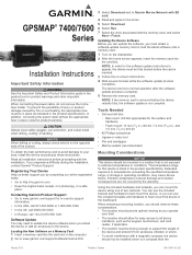
... sales receipt, or a photocopy, in storage or operating conditions, may need to update the device software when you experience difficulty during the installation, contact Garmin® Product Support. GPSMAP® 7400/7600 Series
Installation Instructions
Important Safety Information
WARNING See the Important Safety and Product Information guide in the product box for easy access to all...
Garmin GPSMAP 7610xsv Reviews
We have not received any reviews for Garmin yet.