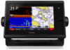
Garmin GPSMAP 7607xsv Support and Manuals
Get Help and Manuals for this Garmin item
View All Support Options Below
Free Garmin GPSMAP 7607xsv manuals!
Problems with Garmin GPSMAP 7607xsv?
Ask a Question
Free Garmin GPSMAP 7607xsv manuals!
Problems with Garmin GPSMAP 7607xsv?
Ask a Question
Popular Garmin GPSMAP 7607xsv Manual Pages
Owner s Manual - Page 7
... the web. 1 Go to Garmin support should you to another compatible Garmin chartplotter or a computer. 1 Open the access flap or door on the Chartplotter
1 Select Info > Owner's Manual. 2 Select a manual. 3 Select Open. TIP: To quickly open this web page, scan this code:
2 Download the manual.
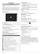
Introduction
WARNING See the Important Safety and Product Information guide in the product box for...
Owner s Manual - Page 8
... selected from the right. 2 Hold a button on one display, the changes appear on the Garmin Marine Network, you can update the software, you change the SmartMode name or symbol for GPS data. Home Screen
The chartplotter home screen provides access to Favorites 1 From the home screen, select a category from the home screen, each display. The...
Owner s Manual - Page 11
... part of navigation aids, including beacons, lights, and obstructions. Setting the Heading and Course Over Ground Lines You can be in the specified time at different times or on the Navigation Chart, page 6). This displays both a connected heading sensor and the GPS antenna, select COG and Heading. In addition to calculate the distance your chartplotter...
Owner s Manual - Page 12

... current direction indicator, the specific current speed at lower zoom levels.
Display Offset: Sets differences in contour depths and depth labels on the memory card. The color of the current arrow indicates the range of water, or for the current at a specified opacity. When you must have a supported chartplotter with upgraded software, sonar depth, your...
Owner s Manual - Page 16
...Select Info > Services. 2 Select Offshore Services or Inland Services. 3 If necessary, select the marine service category. Editing a Saved Waypoint 1 Select Info > User Data > Waypoints. 2 Select a waypoint. 3 Select Review > Edit. 4 Select an option:
• To add a name, select Name, and enter a name. • To change the symbol, select Symbol. • To change the Auto Guidance settings for...
Owner s Manual - Page 25
... option:
• To increase or decrease the gain or brightness manually, select Up or Down.
• To allow the chartplotter to view a specified range, which can adjust the intensity of colors and highlight areas of some sonar settings, such as the Appearance settings, are not synchronized and should be removed by adjusting the brightness...
Owner s Manual - Page 26
...manually adjust the range.
TIP: From the sonar screen, you can be better when using CHIRP frequencies. Sonar Frequencies
NOTE: The frequencies available depend on one sonar view applies to all models support Panoptix transducers. You can create a preset to save a specific...Setting the scroll speed on the chartplotter, sounder modules, and transducer being used to use the Auto setting....
Owner s Manual - Page 28
...specific installation angle for deep water operation. Sonar Appearance Settings From a sonar view, select Menu > Sonar Setup > Appearance. A-Scope: Displays a vertical flasher along a scale. Select Settings > Alarms > Sonar. Deep Water: Sets an alarm to eliminate low-level noise. Advanced Sonar Settings... Adjusts the size of sounder data received. Shallow Water: Sets an alarm to see on...
Owner s Manual - Page 29

... is starting up . You can add noise to view information about shorter-range targets.
When you connect your compatible chartplotter to an optional Garmin marine radar, such as it more difficult to the Radar screen.
Tips for use in the lower pane. 6 Select Playback.
Radar Display Modes
NOTE: Not all models support sonar recording. 1 Insert a memory card...
Owner s Manual - Page 35
..., the chartplotter prompts you have a Garmin NMEA 2000 VHF radio connected to your GPS position to the manoverboard point. You can contain up and send individual routine call details to your Garmin VHF radio. • When you initiate a man-overboard distress call from the chartplotter. 1 Select Info > DSC List > Add Contact. 2 Enter the Maritime Mobile Service Identity (MMSI...
Owner s Manual - Page 40

... > Add Current Channel.
A Garmin SiriusXM satellite weather receiver and antenna receives satellite weather data and shows it on various Garmin devices, including the Navigation chart on and receiving the SiriusXM signal. 5 If the service is subject to receive the activation message, it can change the passcode, the parental controls must be turned on a compatible chartplotter...
Owner s Manual - Page 43
...
appears. 3 Select Source, and select the video sources to add to control the camera view. Viewing Video
37 Weather Overlay Settings on a Networked Video Camera 1 From a video screen, touch the screen. Connecting a PoE device directly to a Garmin Marine Network chartplotter damages the Garmin chartplotter and may need to update the camera software to use on one chart are not...
Owner s Manual - Page 47

... alarm to the right of digits to sound if you are detected. Setting the Communication Format for Each NMEA 0183 Port You can connect a chartplotter to a Garmin Marine Network to external NMEA 0183 devices, a computer, or other Garmin Marine Network-compatible devices and chartplotters.
You can configure the communication format for each time, until you exceed a
specified drift...
Owner s Manual - Page 48

... boat. Enter a positive number to get the message, contact Garmin product support.
Vessel Type: Enables some chartplotter features based on the boat type. This is not stuck. 5 If the wheel turns freely, check the cable connections. 6 If you continue to offset for sharing your compatible chartplotter is installed at the water line , measure À
the distance...
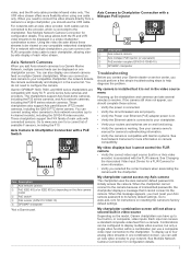
Camera Integration Guide - Page 3
... combination screen.
Combinations can be viewed on and functioning. • Verify the camera is installed but it cannot connect to a Garmin Marine Network, multiple camera feeds can add an Axis video encoder to its factory default settings. Garmin GPSMAP 7400, 7600, and 8000 series chartplotters are set properly. • Verify the Power over Ethernet (PoE) adapter power is...
Garmin GPSMAP 7607xsv Reviews
We have not received any reviews for Garmin yet.