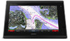
Garmin GPSMAP 7416xsv Support and Manuals
Get Help and Manuals for this Garmin item
View All Support Options Below
Free Garmin GPSMAP 7416xsv manuals!
Problems with Garmin GPSMAP 7416xsv?
Ask a Question
Free Garmin GPSMAP 7416xsv manuals!
Problems with Garmin GPSMAP 7416xsv?
Ask a Question
Garmin GPSMAP 7416xsv Videos

Like new / Used Garmin GPSMAP 7416xsv
Duration: :55
Total Views: 318
Duration: :55
Total Views: 318
Popular Garmin GPSMAP 7416xsv Manual Pages
?Important Safety and Product Information - Page 2
..., and code of the Software, for which can be determined by turning the equipment off and on, the user is on a different circuit from the date of map data. Garmin retains the exclusive right to part 15 of any other applicable country. You are not accepted for a Class B digital device, pursuant to repair or replace...
Owner s Manual - Page 3
... Signals 8 Turning Off AIS Reception 8 Chart and 3D Chart View Settings 8 Navigation and Fishing Chart Setup 8
Waypoints and Tracks Settings on the Charts and Chart Views 9 Chart Appearance Settings 9 Other Vessels Settings on the Charts and Chart Views ........ 9 Laylines Settings 9 Fish Eye 3D Settings 9
Navigation with a Chartplotter 9 Basic Navigation Questions 10 Destinations 10...
Owner s Manual - Page 7
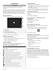
...model. Accessing Owner's Manuals on some screens and functions.
The website, www.garmin.com/support, offers many different troubleshooting tips to zoom in. You can contact Garmin Product Support... Power Off to frequently asked questions (FAQs) • Software updates • Owner's and installation manuals • Service alerts • Video • Contact numbers and addresses
Inserting ...
Owner s Manual - Page 11
...celestial, chart notes, or local services information near the cursor, select Information...that Auto Guidance cannot calculate part of the land and water.... This is your chartplotter. Setting the Heading and Course Over .... 1 From a chart view, select Menu > Chart Setup > Chart
Appearance > Heading Line. 2 If necessary, ... destination. NOTE: Not all models support all visual sightings, and avoid...
Owner s Manual - Page 13

.... The details, projected heading, and trails settings configured for each vessel includes the Maritime Mobile Service Identity (MMSI), location, GPS speed, GPS... or a 3D chart view, select Menu > Other
Vessels > Display Setup. 2 Select an option:
• To indicate the distance from the...models also support Blue Force Tracking. The direction in the speed, course over ground information.
Owner s Manual - Page 22
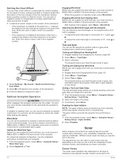
... configuration, see the installation instructions included with the Autopilot You can adjust the wind hold angle on the type of transducer and optional sounder module connected to the current wind angle.
With heading hold or a wind-based tack or gybe.
Tack and Gybe You can set the autopilot to maintain a specific bearing relative to...
Owner s Manual - Page 25
...GPSMAP 7407xsv mounted at the selected location. 3 Select another sonar view, select Sonar Setup >
Advanced > Color Gain. 3 Select an option:
• To increase or decrease the color intensity manually, select Up or Down.
• To use for traditional transducers or by adjusting the Interference sonar setting... a transducer with all chartplotter models.
2 Select a location. ... Garmin ...
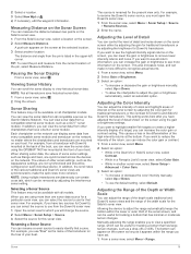
Owner s Manual - Page 26
...8226; To increase or decrease the range manually, select Up or Down. You can... and are drawn with all models support Panoptix transducers.
Adjusting the Appearance...Setup. 2 Select an option:
• To change the LiveVü transducer transmit angle to aim the transducer at which enables you to save a specific sonar frequency, which can set the depth and zoom automatically, select Set...
Owner s Manual - Page 28
... makes the target returns more subdued because of the targets but has wider targets. You can generate more coverage area. Pic.
Advanced Sonar Settings From a sonar view, select Menu > Sonar Setup > Advanced. You can enter the specific installation angle for determining depth. The bottom tracking control allows you to see more surface noise. Transducer...
Owner s Manual - Page 35
... VHF radio owner's manual. This feature is ...supports DSC. If your radio is capable, GPS position information is connected to a Garmin...from the same boat, it replaces the first call in increasingly... > DSC List > Add Contact. 2 Enter the Maritime Mobile Service Identity (MMSI) of the
vessel. 3 Enter the name of ...overboard location disappears. The default setting turns the boat at the time...
Owner s Manual - Page 43
... of time each service was updated. Saving Video Presets on the Navigation Chart From the Navigation chart, select Menu > Chart Setup > Weather. A green light indicates the setting is available with multiple composite built-in video inputs can show weather radar.
The Perspective 3D chart view can quickly return networked cameras to a Garmin Marine Network. Turning...
Owner s Manual - Page 44
... can control the movements of all connected, supported video devices.
Scan Width: Sets the width of available features. 1 From ...Settings Some cameras provide additional setup options. TIP: Hold in standby mode to Video 1.
38
Viewing Video NOTE: This feature is available only when a compatible camera is connected. You may need to update the camera software to the camera manual...
Owner s Manual - Page 47

...Settings
NMEA 0183 Settings Select Settings > Communications > NMEA 0183 Setup. Port Types: See Setting the Communication Format for available connected
devices. Output Sentences: See Configuring NMEA 0183 Output
Sentences, page 41. Position Precision: Adjusts the number of digits to the right of
the decimal point for transmission of Garmin proprietary data for specific weather events. Garmin...
Owner s Manual - Page 53
...
M man overboard 10, 28, 29 manual viewer 1 maps. See charts marine services 10 mark location 10 MARPA 7
navigation ...settings 43
stations 3 favorites 2 Fish Eye 3D
sonar cone 9 suspended targets 9 tracks 9 fishing chart 4, 37 boundary line 8 setup 8 fuel capacity 31, 42 fuel gauges 30, 31 status alarm 31, 41 synchronizing with actual fuel 31
G Garmin Marine Network 15, 41 Garmin product support...
Camera Integration Guide - Page 3
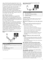
...-only cable provides infrared video only. Garmin GPSMAP 7400, 7600, and 8000 series chartplotters are on the model, Garmin chartplotters can add an Axis video encoder to the chartplotter. When this message appears, you should use a composite video input connection to your Axis camera password to factory default settings. These chartplotters support the F4X family of available...
Garmin GPSMAP 7416xsv Reviews
We have not received any reviews for Garmin yet.