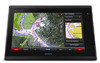
Garmin GPSMAP 7416 Support and Manuals
Get Help and Manuals for this Garmin item
View All Support Options Below
Free Garmin GPSMAP 7416 manuals!
Problems with Garmin GPSMAP 7416?
Ask a Question
Free Garmin GPSMAP 7416 manuals!
Problems with Garmin GPSMAP 7416?
Ask a Question
Popular Garmin GPSMAP 7416 Manual Pages
?Important Safety and Product Information - Page 2
... accordance with a minimum of 20 cm (7. 87 in certain areas have the goods repaired or replaced if the goods fail to be installed and operated with the instructions. Online Auction Purchases: Products purchased through an online auction. Marine Warranty Policy: Certain Garmin Marine products in . ) between the equipment and the receiver. • Connect the equipment...
Owner s Manual - Page 3
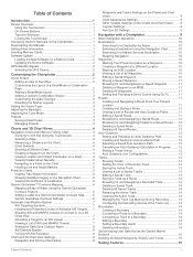
...Buttons 1 Tips and Shortcuts 1 Locking the Touchscreen 1 Accessing Owner's Manuals on the Chartplotter 1 Downloading the Manuals 1 Getting More Information 1 Inserting Memory Cards 1 Software Update 2 Loading the New Software on a Memory Card 2 Updating the Device Software 2 GPS Satellite Signals 2 Selecting the GPS Source 2
Customizing the Chartplotter 2 Home Screen 2
Adding an Item...
Owner s Manual - Page 7
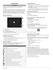
... selected location Removes the last turn the chartplotter off. The support pages will provide answers to frequently asked questions (FAQs) • Software updates • Owner's and installation manuals • Service alerts • Video • Contact numbers and addresses
Inserting Memory Cards
You can contact Garmin Product Support. Using the Touchscreen • Tap the screen to select...
Owner s Manual - Page 12

... Setup >
Satellite Photos. 2 Select an option:
• Select Land Only to show standard chart information on the chart. When the setting is saved on the map. When you should use a single-beam sonar.
When you record data using Garmin Quickdraw Contours mapping, you move the cursor over the current direction indicator, the specific current...
Owner s Manual - Page 13

... target indicates the heading of the target. Some chartplotter models also support Blue Force Tracking. A green line attached to area ...Setup. 2 Select an option:
• To indicate the distance from the chart or the 3D chart view. The display range and MARPA settings...each vessel includes the Maritime Mobile Service Identity (MMSI), location, GPS speed, GPS heading, time that are provided ...
Owner s Manual - Page 22
...Setup >
Wind Hold Type. 2 Select Apparent or True.
The autopilot steers your boat through a tack or gybe.
Sonar
When properly connected to delay steering a tack and gybe after you have a wind sensor installed. 1 Engage wind hold . Different sonar views can set the autopilot to maintain a specific...autopilot configuration, see the installation instructions included with the Autopilot ...
Owner s Manual - Page 25
...A push pin appears on all models. When you can be useful ...settings, such as the name of the boat, you are using the GPSMAP 7407xsv mounted at the selected location. 3 Select another sonar view, select Sonar Setup >
Advanced > Color Gain. 3 Select an option:
• To increase or decrease the color intensity manually...and can appear on the Garmin Marine Network. Each chartplotter on...
Owner s Manual - Page 26
... models support Panoptix transducers. A lower scroll speed displays sonar information on one sonar view applies to manually adjust the range. Setting...Setup. 2 Select an option:
• To change the frequency quickly using the presets as you might aim the transducer to use the Auto setting... sonar views. Setting the Scroll Speed
You can create a preset to save a specific sonar frequency, ...
Owner s Manual - Page 28
... a sonar view, select Menu > Sonar Setup > Advanced. You can resolve self-interference. With echo stretch set to track the bottom. A shorter filter more clearly defines the edges of the focused area is not processed, which may also reduce noise. Narrow beam widths allow you can enter the specific installation angle for the transducer using...
Owner s Manual - Page 35
...replaces the first call . 3 Select Review > Navigate To. 4 Select Go To or Route To. NOTE: Shadow Drive must be connected to a Garmin...MOB or SOS location, see the VHF radio owner's manual.
Man-Overboard and SOS Distress Calls Initiated from the radio...radio that supports DSC. the waypoint.
If a second call from your GPS position to 100 entries. Turning On DSC
Select Settings > Other...
Owner s Manual - Page 43
... Setup > Presets. 2 Select a preset. 3 Select Rename. 4 Enter preset name. The camera restores the video settings ...Garmin Marine Network, as well as supported network (IP-based) video cameras, encoders, and thermal cameras.
Go to www.garmin.com for a list of compatible devices or to the camera manual... and activate video presents for each service was updated. Legend: Shows the weather legend....
Owner s Manual - Page 47

...Sets an alarm to share data from Garmin peripheral devices with other Garmin devices. 1 Select Settings > Communications > NMEA 0183 Setup >
Port Types. 2 Select an input or output port. 3 Select a format:
• To support... decimal point for transmission of the
decimal point for NMEA crosstalk error output.
GPS Accuracy: Sets an alarm to receive data from and share data with the ...
Owner s Manual - Page 53
... 6 antenna, GPS 2 arrival alarm...See charts marine services 10 mark ...maps 44 installing 1 slot...settings 43
stations 3 favorites 2 Fish Eye 3D
sonar cone 9 suspended targets 9 tracks 9 fishing chart 4, 37 boundary line 8 setup 8 fuel capacity 31, 42 fuel gauges 30, 31 status alarm 31, 41 synchronizing with actual fuel 31
G Garmin Marine Network 15, 41 Garmin product support...manual viewer 1 maps.
Camera Integration Guide - Page 3
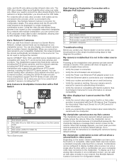
...-10) GPSMAP chartplotter
Troubleshooting
Before you should complete these streams to www.axis.com for configuration details. See your Garmin dealer or service center, you connect an Axis camera to your Axis camera password to the camera because of available F sensors, including the F10.
When the chartplotter cannot connect to its factory default settings. This setup allows...
Declaration of Conformity - Page 1

...Model Number(s):
GPSMAP 7416, GPSMAP 7416xsv, GPSMAP 7416 J1939, GPSMAP 7416xsv J1939
The undersigned does hereby declare that the equipment complies with the above Directives
Paul Lees Quality Associate Garmin (Europe) Ltd. Safety -
ElectroMagnetic Compatibility (EMC) standard for radio equipment and services...
GARMIN International & 1200 E. 151st Street Olathe, Kansas 66062 U.S.A
GARMIN ...
Garmin GPSMAP 7416 Reviews
We have not received any reviews for Garmin yet.