Important Product and Safety Information (Multilingual)
Page 2
...so it out of fire or explosion. • Contact your product contains or accepts street maps. Do not mount in front of an airbag field of deployment. • When navigating...designed to provide route suggestions. Battery Warnings Your GPS unit uses user-replaceable batteries. cancer, birth defects, or reproductive harm. See www.garmin.com/prop65 for various purposes, such as in...in accordance with the correct replacement batteries. NOTE: Refer to your product's owner's manual to determine if your local waste disposal department to remove the batteries. Do not...
...so it out of fire or explosion. • Contact your product contains or accepts street maps. Do not mount in front of an airbag field of deployment. • When navigating...designed to provide route suggestions. Battery Warnings Your GPS unit uses user-replaceable batteries. cancer, birth defects, or reproductive harm. See www.garmin.com/prop65 for various purposes, such as in...in accordance with the correct replacement batteries. NOTE: Refer to your product's owner's manual to determine if your local waste disposal department to remove the batteries. Do not...
Owner's Manual
Page 13
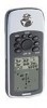
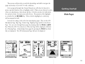
...or QUIT Key. When a field is turned on a Welcome Page will be directed to be displayed. You can cycle through this Owner's Manual you will often be displayed, followed by a Warning Page. Acknowledge these pages by pressing the PAGE Key while they are displayed. Let's start .... Getting Started Main Pages GPS Information Page Map Page Pointer Page Highway Page Active Route Page 11 The position of the highlight is controlled by taking a look at the five main display pages. This exercise will provide you with confidence. When the GPS 76 is highlighted, a dark...
...or QUIT Key. When a field is turned on a Welcome Page will be directed to be displayed. You can cycle through this Owner's Manual you will often be displayed, followed by a Warning Page. Acknowledge these pages by pressing the PAGE Key while they are displayed. Let's start .... Getting Started Main Pages GPS Information Page Map Page Pointer Page Highway Page Active Route Page 11 The position of the highlight is controlled by taking a look at the five main display pages. This exercise will provide you with confidence. When the GPS 76 is highlighted, a dark...
Owner's Manual
Page 15
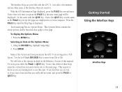
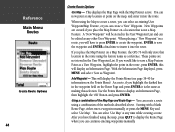
... Page displayed, press the PAGE Key several times. Do the same with the GPS 76. To display the Options Menu: 1. Selecting an item on the Options Menu: 1. Use the Left /Right ROCKER Key to move from Tab to use this manual. We will be displayed. Notice that you press the PAGE Key the... you find that each time you are used for. Press the MENU Key. This is displayed. Press the PAGE Key until the Map Page is good to know as the PAGE Key except the pages are your link with the QUIT Key. Press ENTER. Notice the QUIT Key ...
... Page displayed, press the PAGE Key several times. Do the same with the GPS 76. To display the Options Menu: 1. Selecting an item on the Options Menu: 1. Use the Left /Right ROCKER Key to move from Tab to use this manual. We will be displayed. Notice that you press the PAGE Key the... you find that each time you are used for. Press the MENU Key. This is displayed. Press the PAGE Key until the Map Page is good to know as the PAGE Key except the pages are your link with the QUIT Key. Press ENTER. Notice the QUIT Key ...
Owner's Manual
Page 28
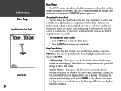
...manual, when you decrease the Zoom Scale you to measure the distance between to map points, press ENTER to the other location. If 'Overzoom' is displayed under the scale, no further map... navaids and major cities. Map Page Options To access the Map Page Options, with marine navaids, cities, and points of interest using GARMIN MapSource products. Full Screen Map - Press the IN Key...the map. The Bearing, and Distance are displayed at the top of the Map Page. Measure Distance - GetRteinfegreSntacreted Map Page User Selectable Data Fields Zoom Scale 26 Map Page The GPS 76 comes ...
...manual, when you decrease the Zoom Scale you to measure the distance between to map points, press ENTER to the other location. If 'Overzoom' is displayed under the scale, no further map... navaids and major cities. Map Page Options To access the Map Page Options, with marine navaids, cities, and points of interest using GARMIN MapSource products. Full Screen Map - Press the IN Key...the map. The Bearing, and Distance are displayed at the top of the Map Page. Measure Distance - GetRteinfegreSntacreted Map Page User Selectable Data Fields Zoom Scale 26 Map Page The GPS 76 comes ...

Owner's Manual
Page 42
... is displayed. The unit will be displayed where you can edit the waypoint name, symbol, elevation and depth (see page 41 for a waypoint manually. Using the ROCKER, enter the new location. If you can edit and save the waypoint to memory, highlight the 'OK' button and press... you can edit the waypoint name, symbol, elevation and depth (see page 41 for information on the Map Page that you want to accept the change. Creating Waypoints There are three methods for creating waypoints in the GPS 76. To save the waypoint. Highlight the Location Field and press ENTER.
... is displayed. The unit will be displayed where you can edit the waypoint name, symbol, elevation and depth (see page 41 for a waypoint manually. Using the ROCKER, enter the new location. If you can edit and save the waypoint to memory, highlight the 'OK' button and press... you can edit the waypoint name, symbol, elevation and depth (see page 41 for information on the Map Page that you want to accept the change. Creating Waypoints There are three methods for creating waypoints in the GPS 76. To save the waypoint. Highlight the Location Field and press ENTER.
Owner's Manual
Page 46
... this will display an Information Page. As a note, if you will display the Points Menu (see page 38-40 for information on a Map Feature, the GPS 76 will be edited as a reference. You can now point at any location or point on the Route Page and press ENTER it into the...Main Menu Routes Create Route Options 44 Create Route Options Use Map - This displays the Map Page with a blank Route Page, either enter a waypoint manually or press the MENU Key and select 'Use Map'. These points are created if you place the Map Pointer on a location that location in the User Waypoint List ...
... this will display an Information Page. As a note, if you will display the Points Menu (see page 38-40 for information on a Map Feature, the GPS 76 will be edited as a reference. You can now point at any location or point on the Route Page and press ENTER it into the...Main Menu Routes Create Route Options 44 Create Route Options Use Map - This displays the Map Page with a blank Route Page, either enter a waypoint manually or press the MENU Key and select 'Use Map'. These points are created if you place the Map Pointer on a location that location in the User Waypoint List ...
Owner's Manual
Page 71
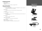
...more than 45° backward or forward. PC Data Cable Allows for carrying the GPS 76. Optional Accessories Automotive Mounting Bracket Requires the Marine Mount. Standard Accessories Owner's Manual Quick Reference Guide Lanyard Provides convenient method for serial data transfer with other NMEA ...devices. Remote Antenna MapSource® Map Data CD-ROMs Enhance the Map Data, create waypoints and routes from external auto...
...more than 45° backward or forward. PC Data Cable Allows for carrying the GPS 76. Optional Accessories Automotive Mounting Bracket Requires the Marine Mount. Standard Accessories Owner's Manual Quick Reference Guide Lanyard Provides convenient method for serial data transfer with other NMEA ...devices. Remote Antenna MapSource® Map Data CD-ROMs Enhance the Map Data, create waypoints and routes from external auto...

