Important Product and Safety Information (Multilingual)
Page 2
...place where driver's unsecured on the unit to all driving conditions. Battery Warnings Your GPS unit uses user-replaceable batteries. It is designed to provide route suggestions. cancer, birth..., its packaging, and its components glove box. This notice is blocked. See www.garmin.com/prop65 for navigator attentiveness regarding road closures or road conditions, traffic congestion, weather ...or unit. • Keep the batteries away from street signs, visual sightings, and maps. Do not input destinations, change settings, or access any functions requiring prolonged use ...
...place where driver's unsecured on the unit to all driving conditions. Battery Warnings Your GPS unit uses user-replaceable batteries. It is designed to provide route suggestions. cancer, birth..., its packaging, and its components glove box. This notice is blocked. See www.garmin.com/prop65 for navigator attentiveness regarding road closures or road conditions, traffic congestion, weather ...or unit. • Keep the batteries away from street signs, visual sightings, and maps. Do not input destinations, change settings, or access any functions requiring prolonged use ...
Important Product and Safety Information (Multilingual)
Page 3
... any interference received, including interference that is prohibitively expensive. Important Information Map Data Information: One of the goals of Garmin is to provide customers with all data sources contain some countries, complete and accurate map information is either not available or is available to us at a ... state and local laws and ordinances. Perchlorate Material: Replaceable coin cell batteries may apply. Some state laws prohibit drivers from the GPS unit. • Consult the dealer or an experienced radio/TV technician for any state or local law or ordinance relating to ...
... any interference received, including interference that is prohibitively expensive. Important Information Map Data Information: One of the goals of Garmin is to provide customers with all data sources contain some countries, complete and accurate map information is either not available or is available to us at a ... state and local laws and ordinances. Perchlorate Material: Replaceable coin cell batteries may apply. Some state laws prohibit drivers from the GPS unit. • Consult the dealer or an experienced radio/TV technician for any state or local law or ordinance relating to ...
Important Product and Safety Information (Multilingual)
Page 4
...that fail in compliance with the essential requirements and other special offers from the original retailer is required as the proof of map data in this product is intended to be used only as to any transportation cost. SUCH REMEDY SHALL BE YOUR SOLE... RESULTING Industry Canada Compliance Category I radiocommunication devices comply with Industry Canada Standard RSS-310. To obtain warranty service, contact your Garmin product: www.garmin.com. Garmin will , at no warranty as a travel aid and must be returned to operate this distributor provides local service for parts or...
...that fail in compliance with the essential requirements and other special offers from the original retailer is required as the proof of map data in this product is intended to be used only as to any transportation cost. SUCH REMEDY SHALL BE YOUR SOLE... RESULTING Industry Canada Compliance Category I radiocommunication devices comply with Industry Canada Standard RSS-310. To obtain warranty service, contact your Garmin product: www.garmin.com. Garmin will , at no warranty as a travel aid and must be returned to operate this distributor provides local service for parts or...
Owner's Manual
Page 7
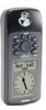
... Cautions 2 FCC Compliance Statement 3 Features 4 Table of Contents 5 "How To" Index 6 GPS 72 Unit Features 7 Section Two: Reference 7-47 Initializing the GPS Receiver 7-8 GPS Information Page 9-11 Map Page 12-17 Pointer Page 18 Highway Page 19-21 Main Menu Page 21-47 Trip Computer ...Tab........... 47 Appendices 48-65 Appendix A: Specifications 48 Appendix B: Wiring & Interfacing.... 49 Appendix C: Time Offsets 50 Appendix D: Map Datums........... 51-52 Appendix E: Navigation Terms .... 53-54 Appendix F: Messages 55-56 Appendix G: Loran TD 57-58 Appendix H: Accessories ...
... Cautions 2 FCC Compliance Statement 3 Features 4 Table of Contents 5 "How To" Index 6 GPS 72 Unit Features 7 Section Two: Reference 7-47 Initializing the GPS Receiver 7-8 GPS Information Page 9-11 Map Page 12-17 Pointer Page 18 Highway Page 19-21 Main Menu Page 21-47 Trip Computer ...Tab........... 47 Appendices 48-65 Appendix A: Specifications 48 Appendix B: Wiring & Interfacing.... 49 Appendix C: Time Offsets 50 Appendix D: Map Datums........... 51-52 Appendix E: Navigation Terms .... 53-54 Appendix F: Messages 55-56 Appendix G: Loran TD 57-58 Appendix H: Accessories ...
Owner's Manual
Page 8
... some of the more important procedures you will use on your new GPS 72. 6 TO DO THIS SEE PAGE(S): Initialize the GPS receiver 7 Learn About the Map page 12-17 Zoom in or out on the Map page 12 Reconfigure the Map page display 12-17 Lear about the Pointer Page 18 Learn about...
... some of the more important procedures you will use on your new GPS 72. 6 TO DO THIS SEE PAGE(S): Initialize the GPS receiver 7 Learn About the Map page 12-17 Zoom in or out on the Map page 12 Reconfigure the Map page display 12-17 Lear about the Pointer Page 18 Learn about...
Owner's Manual
Page 10
... select an option, place the highlight over the option then press ENTER. This menu contains the options 'Automatic' or 'Use Map'. Depending on the Map Page to select your approximate location and the unit will continue to acquire satellites normally. 'Automatic' may be displayed. Stored ...Initializing the GPS Receiver Initialization Options Initialization Options If the GPS 72 is unable to determine its location, an options menu will be incorrect. If you are indoors and the GPS is unable to locate satellites. If you select 'Use Map' you select 'Simulator', the GPS receiver is...
... select an option, place the highlight over the option then press ENTER. This menu contains the options 'Automatic' or 'Use Map'. Depending on the Map Page to select your approximate location and the unit will continue to acquire satellites normally. 'Automatic' may be displayed. Stored ...Initializing the GPS Receiver Initialization Options Initialization Options If the GPS 72 is unable to determine its location, an options menu will be incorrect. If you are indoors and the GPS is unable to locate satellites. If you select 'Use Map' you select 'Simulator', the GPS receiver is...
Owner's Manual
Page 13
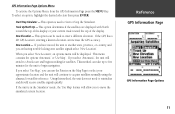
... onto satellite signals select 'New Location'. If you to enter a different elevation. InRterofedruecntcioen GPS Information Page GPS Information Page Options 11 This option is in the 'Simulator' mode, the 'Use Map' feature will be used to select your current track toward the top of the display.... you select 'Automatic', the unit will continue to begin searching for satellite reference. If the GPS has a 2D GPS Location, entering a known elevation can use the Pointer on the Map Page to Start or Stop the Simulator. If the unit is used to move the simulated current...
... onto satellite signals select 'New Location'. If you to enter a different elevation. InRterofedruecntcioen GPS Information Page GPS Information Page Options 11 This option is in the 'Simulator' mode, the 'Use Map' feature will be used to select your current track toward the top of the display.... you select 'Automatic', the unit will continue to begin searching for satellite reference. If the GPS has a 2D GPS Location, entering a known elevation can use the Pointer on the Map Page to Start or Stop the Simulator. If the unit is used to move the simulated current...
Owner's Manual
Page 14
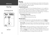
...To select an option from the Menu, highlight the desired selection then press ENTER. InRterofedruecntcioen Map Page User Selectable Data Fields Zoom Scale 12 Map Page The GPS 72 comes with the Map Page displayed, press the MENU Key. The current Zoom Scale setting is available. As ... allowing you will view a smaller area with marine navaids, cities, and points of interest using GARMIN MapSource products. If 'Overzoom' is displayed under the scale, no further map information is displayed in greater detail or a larger area with less detail. Measure Distance - This option ...
...To select an option from the Menu, highlight the desired selection then press ENTER. InRterofedruecntcioen Map Page User Selectable Data Fields Zoom Scale 12 Map Page The GPS 72 comes with the Map Page displayed, press the MENU Key. The current Zoom Scale setting is available. As ... allowing you will view a smaller area with marine navaids, cities, and points of interest using GARMIN MapSource products. If 'Overzoom' is displayed under the scale, no further map information is displayed in greater detail or a larger area with less detail. Measure Distance - This option ...

Owner's Manual
Page 15
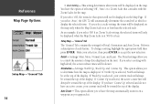
..., Small, Med, and Large. If you select 'Off', the item will be displayed with a name or label in the text size selected. InRterofedruecntcioen Map Page Options Map Page Options 13 To change a data type, place the highlight over the desired data field, then press ENTER. This option allow you to...Point', and 'Line' Tabs have the option of text used when displaying a name or label for 'Text', 'Zoom' or both. There are arranged on the Map Page. If you to accept the selection. You have setting for an item on a tab menu making it easy to understand how they affect the...
..., Small, Med, and Large. If you select 'Off', the item will be displayed with a name or label in the text size selected. InRterofedruecntcioen Map Page Options Map Page Options 13 To change a data type, place the highlight over the desired data field, then press ENTER. This option allow you to...Point', and 'Line' Tabs have the option of text used when displaying a name or label for 'Text', 'Zoom' or both. There are arranged on the Map Page. If you to accept the selection. You have setting for an item on a tab menu making it easy to understand how they affect the...
Owner's Manual
Page 16
As an example, if you select 500 ft as you select 'Auto', the GPS 72 will automatically determine the zoom level at the top of the display. To change a ...be toward the top of the display. Detail - If you have 'Course Up' selected and do not have the map automatically zoom in on the unit. If 'Track Up' is selected, the active course line will be toward the top... of the display. If 'Course Up' is selected, your current track will not be displayed on the map. If you select a setting with the Zoom Scales for that option will always be slower. This option allows you ...
As an example, if you select 500 ft as you select 'Auto', the GPS 72 will automatically determine the zoom level at the top of the display. To change a ...be toward the top of the display. Detail - If you have 'Course Up' selected and do not have the map automatically zoom in on the unit. If 'Track Up' is selected, the active course line will be toward the top... of the display. If 'Course Up' is selected, your current track will not be displayed on the map. If you select a setting with the Zoom Scales for that option will always be slower. This option allows you ...

Owner's Manual
Page 17
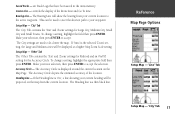
.... Lat Lon Grid - If you to accept the selection. This option allows you select 'Auto', and have the MapSource options set to turn map data displayed on the grid. Each of the options has a 'Text' and 'Zoom' setting. This option sets the display parameters for the ...Basemap, MapSource, Lat Lon Grids, and Grid Labels. InRterofedruecntcioen Map Page Options Setup Map - 'Map' Tab 15 To change a setting, highlight the appropriate field then press ENTER. Make your new selection, then press ENTER to accept...
.... Lat Lon Grid - If you to accept the selection. This option allows you select 'Auto', and have the MapSource options set to turn map data displayed on the grid. Each of the options has a 'Text' and 'Zoom' setting. This option sets the display parameters for the ...Basemap, MapSource, Lat Lon Grids, and Grid Labels. InRterofedruecntcioen Map Page Options Setup Map - 'Map' Tab 15 To change a setting, highlight the appropriate field then press ENTER. Make your new selection, then press ENTER to accept...

Owner's Manual
Page 18
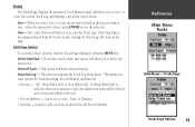
...has been loaded in an Active Route. the Track Log is the bread crumb trail that are in the unit. InRterofedruecntcioen Map Page Options Setup Map - 'Waypoint' Tab 16 Setup Map - 'Point' Tab Active Route Waypoint - include points such as restaurants, hotels, gas stations, etc. are only ... Active Route will be landmarks, milemarkers, hazards, light houses, buoys, etc. Exit - Navaids can be displayed with large text on the Map that exist in MapSource data. Points of Interest, Geo and Exit option settings. Make your new selection, then press ENTER to accept the ...
...has been loaded in an Active Route. the Track Log is the bread crumb trail that are in the unit. InRterofedruecntcioen Map Page Options Setup Map - 'Waypoint' Tab 16 Setup Map - 'Point' Tab Active Route Waypoint - include points such as restaurants, hotels, gas stations, etc. are only ... Active Route will be landmarks, milemarkers, hazards, light houses, buoys, etc. Exit - Navaids can be displayed with large text on the Map that exist in MapSource data. Points of Interest, Geo and Exit option settings. Make your new selection, then press ENTER to accept the ...
Owner's Manual
Page 19
... a setting, highlight the field then press ENTER. controls the display of the location. The Bearing Line will be projected on the Map Page. Setup Map - 'Other' Tab The 'Other' Tab contains the 'Text' and 'Zoom' settings for Railroad and an On/Off setting for Large City...the current location. The Accuracy Circle depicts the estimated accuracy of the Route Line and Go To Line. Saved Tracks - InRterofedruecntcioen Map Page Options Setup Map - 'Line' Tab Setup Map - 'City' Tab 17 If 'Auto' is a thin black line. This can be used to your current heading will ...
... a setting, highlight the field then press ENTER. controls the display of the location. The Bearing Line will be projected on the Map Page. Setup Map - 'Other' Tab The 'Other' Tab contains the 'Text' and 'Zoom' settings for Railroad and an On/Off setting for Large City...the current location. The Accuracy Circle depicts the estimated accuracy of the Route Line and Go To Line. Saved Tracks - InRterofedruecntcioen Map Page Options Setup Map - 'Line' Tab Setup Map - 'City' Tab 17 If 'Auto' is a thin black line. This can be used to your current heading will ...

Owner's Manual
Page 20
... ENTER. This option allow you change direction, the Compass Ring will be moving for navigation when a straight line course can not be displayed on the map. Using the ROCKER, scroll through the available selections. When you change a data type, place the highlight over the desired data field, then press ENTER...
... ENTER. This option allow you change direction, the Compass Ring will be moving for navigation when a straight line course can not be displayed on the map. Using the ROCKER, scroll through the available selections. When you change a data type, place the highlight over the desired data field, then press ENTER...

Owner's Manual
Page 21
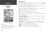
... type, place the highlight over the desired data field, then press ENTER. Highway Page Options To access the Highway Page Options, with the Map Page. Change Data Fields - Using the ROCKER, scroll through the available selections. Setup Page Layout - As you are within the display area will ... MENU Key. When you approach your destination, the message "Arriving at Destination" will be shown, the Zoom Level can be displayed on the map. This option allows you to select the type of data you to select the text size and the number of displaying: None, Small (1 Row...
... type, place the highlight over the desired data field, then press ENTER. Highway Page Options To access the Highway Page Options, with the Map Page. Change Data Fields - Using the ROCKER, scroll through the available selections. Setup Page Layout - As you are within the display area will ... MENU Key. When you approach your destination, the message "Arriving at Destination" will be shown, the Zoom Level can be displayed on the map. This option allows you to select the type of data you to select the text size and the number of displaying: None, Small (1 Row...
Owner's Manual
Page 25
...'. Tracks The Tracks Page displays the amount of Track Memory used to delete the saved track. Save - Tracks Page Tracks Page Options 23 If the Map Page is used , will delete all of any Saved Tracks. Track Page Options To access the Track Options, with the Tracks Page displayed, press the... in the log you to save . If 'Wrap When Full' is selected, when track memory is full, the oldest track point will clean up the map.
...'. Tracks The Tracks Page displays the amount of Track Memory used to delete the saved track. Save - Tracks Page Tracks Page Options 23 If the Map Page is used , will delete all of any Saved Tracks. Track Page Options To access the Track Options, with the Tracks Page displayed, press the... in the log you to save . If 'Wrap When Full' is selected, when track memory is full, the oldest track point will clean up the map.
Owner's Manual
Page 26
... Saved Track, highlight the desired track then press ENTER. This will display the Saved Track on the Map and Highway Pages. Delete Button - There are saved the GPS 72 will initiate TracBack Navigation. When tracks are four Option Buttons along the most recent Track. 24 Track Information... Page To access information on Map and Highway - OK Button - You will allow a Saved Track to change the ...
... Saved Track, highlight the desired track then press ENTER. This will display the Saved Track on the Map and Highway Pages. Delete Button - There are saved the GPS 72 will initiate TracBack Navigation. When tracks are four Option Buttons along the most recent Track. 24 Track Information... Page To access information on Map and Highway - OK Button - You will allow a Saved Track to change the ...
Owner's Manual
Page 27
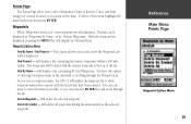
... listed with the letters that have the option of Interest, Cities, and Exits using your current location or a location on the map. Find Nearest - As you enter a waypoint name, the GPS 72 will display a list containing the nearest waypoints within a 100 mile radius. Will delete the selected waypoint. will update the waypoint list...
... listed with the letters that have the option of Interest, Cities, and Exits using your current location or a location on the map. Find Nearest - As you enter a waypoint name, the GPS 72 will display a list containing the nearest waypoints within a 100 mile radius. Will delete the selected waypoint. will update the waypoint list...
Owner's Manual
Page 28
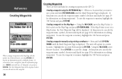
Creating a waypoint on the Map Page and press ENTER/MARK. At this point you can edit the waypoint name, symbol, elevation and depth (see page 29 for creating waypoints in the GPS 72. To save the waypoint to memory, highlight the 'OK' button and press ENTER. The New Waypoint Page will be...unit will display an information page describing the feature. If you want to save the waypoint to accept the change. Using the ROCKER, move the Map Pointer to create a waypoint, from the information page press MENU and with the pointer on a Point of Interest, pressing ENTER will capture its...
Creating a waypoint on the Map Page and press ENTER/MARK. At this point you can edit the waypoint name, symbol, elevation and depth (see page 29 for creating waypoints in the GPS 72. To save the waypoint to memory, highlight the 'OK' button and press ENTER. The New Waypoint Page will be...unit will display an information page describing the feature. If you want to save the waypoint to accept the change. Using the ROCKER, move the Map Pointer to create a waypoint, from the information page press MENU and with the pointer on a Point of Interest, pressing ENTER will capture its...

Owner's Manual
Page 29
... are four options available when creating waypoints. When selected, the Average Waypoint page will return you can use the current location, select a location on the map or use the location of an item found in the 'From' field, highlight the bearing or distance field and press ENTER. Selecting 'Project...
... are four options available when creating waypoints. When selected, the Average Waypoint page will return you can use the current location, select a location on the map or use the location of an item found in the 'From' field, highlight the bearing or distance field and press ENTER. Selecting 'Project...


