Important Product and Safety Information (Multilingual)
Page 2
... batteries away from street signs, visual sightings, and maps. Minimize the amount of fire or explosion. • Contact your product contains or accepts street maps. It is blocked. Warning: This product, its ...mount Do not place where driver's unsecured on the unit to all driving conditions. See www.garmin.com/prop65 for navigator attentiveness regarding road closures or road conditions, traffic congestion, weather conditions,... in death or serious injury. In addition, the GPS unit may use of vision the vehicle is not designed to replace the need for ...
... batteries away from street signs, visual sightings, and maps. Minimize the amount of fire or explosion. • Contact your product contains or accepts street maps. It is blocked. Warning: This product, its ...mount Do not place where driver's unsecured on the unit to all driving conditions. See www.garmin.com/prop65 for navigator attentiveness regarding road closures or road conditions, traffic congestion, weather conditions,... in death or serious injury. In addition, the GPS unit may use of vision the vehicle is not designed to replace the need for ...
Important Product and Safety Information (Multilingual)
Page 3
...in product literature and copyright messages displayed to the consumer. Special handling may contain perchlorate material. Important Information Map Data Information: One of the goals of Garmin is to provide customers with the most complete and accurate cartography that is on , the user is encouraged... installed and used to us at a reasonable cost. In some inaccurate or incomplete data. Some state laws prohibit drivers from the GPS unit. • Consult the dealer or an experienced radio/TV technician for any interference received, including interference that may cause undesired ...
...in product literature and copyright messages displayed to the consumer. Special handling may contain perchlorate material. Important Information Map Data Information: One of the goals of Garmin is to provide customers with the most complete and accurate cartography that is on , the user is encouraged... installed and used to us at a reasonable cost. In some inaccurate or incomplete data. Some state laws prohibit drivers from the GPS unit. • Consult the dealer or an experienced radio/TV technician for any interference received, including interference that may cause undesired ...
Important Product and Safety Information (Multilingual)
Page 4
...copy of the package. Online auction confirmations are not accepted for your local Garmin authorized dealer or call Garmin Product Support for warranty repairs. This warranty is required as the proof of map data in normal use. Category II radiocommunication devices comply with Industry Canada Standard... RSS-210. Limited Warranty This Garmin product is required. Such repairs or replacement will not replace missing ...
...copy of the package. Online auction confirmations are not accepted for your local Garmin authorized dealer or call Garmin Product Support for warranty repairs. This warranty is required as the proof of map data in normal use. Category II radiocommunication devices comply with Industry Canada Standard... RSS-210. Limited Warranty This Garmin product is required. Such repairs or replacement will not replace missing ...
Owner's Manual
Page 7
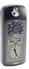
...Cautions 2 FCC Compliance Statement 3 Features 4 Table of Contents 5 "How To" Index 6 GPS 72 Unit Features 7 Section Two: Reference 7-47 Initializing the GPS Receiver 7-8 GPS Information Page 9-11 Map Page 12-17 Pointer Page 18 Highway Page 19-21 Main Menu Page 21-47 Trip Computer ...Tab........... 47 Appendices 48-65 Appendix A: Specifications 48 Appendix B: Wiring & Interfacing.... 49 Appendix C: Time Offsets 50 Appendix D: Map Datums........... 51-52 Appendix E: Navigation Terms .... 53-54 Appendix F: Messages 55-56 Appendix G: Loran TD 57-58 Appendix H: Accessories ...
...Cautions 2 FCC Compliance Statement 3 Features 4 Table of Contents 5 "How To" Index 6 GPS 72 Unit Features 7 Section Two: Reference 7-47 Initializing the GPS Receiver 7-8 GPS Information Page 9-11 Map Page 12-17 Pointer Page 18 Highway Page 19-21 Main Menu Page 21-47 Trip Computer ...Tab........... 47 Appendices 48-65 Appendix A: Specifications 48 Appendix B: Wiring & Interfacing.... 49 Appendix C: Time Offsets 50 Appendix D: Map Datums........... 51-52 Appendix E: Navigation Terms .... 53-54 Appendix F: Messages 55-56 Appendix G: Loran TD 57-58 Appendix H: Accessories ...
Owner's Manual
Page 8
... some of the more important procedures you will use on your new GPS 72. 6 TO DO THIS SEE PAGE(S): Initialize the GPS receiver 7 Learn About the Map page 12-17 Zoom in or out on the Map page 12 Reconfigure the Map page display 12-17 Lear about the Pointer Page 18 Learn about...
... some of the more important procedures you will use on your new GPS 72. 6 TO DO THIS SEE PAGE(S): Initialize the GPS receiver 7 Learn About the Map page 12-17 Zoom in or out on the Map page 12 Reconfigure the Map page display 12-17 Lear about the Pointer Page 18 Learn about...
Owner's Manual
Page 10
... Initialization Options Initialization Options If the GPS 72 is unable to another menu will switch to locate satellites. Stored w/o Batteries - If you select 'Simulator', the GPS receiver is incorrect, select 'Stored w/o Batteries' to search for satellites. When you have moved the unit to determine ..., and you are having trouble locking onto satellite signals select 'New Location'. If you select 'Use Map' you select 'Automatic' the unit will be incorrect. Depending on the Map Page to select your approximate location and the unit will be used when you are in the...
... Initialization Options Initialization Options If the GPS 72 is unable to another menu will switch to locate satellites. Stored w/o Batteries - If you select 'Simulator', the GPS receiver is incorrect, select 'Stored w/o Batteries' to search for satellites. When you have moved the unit to determine ..., and you are having trouble locking onto satellite signals select 'New Location'. If you select 'Use Map' you select 'Automatic' the unit will be incorrect. Depending on the Map Page to select your approximate location and the unit will be used when you are in the...
Owner's Manual
Page 13
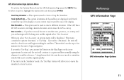
...an option, highlight the desired selection then press ENTER. Track Up/North Up - This method can increase the GPS accuracy. This option is in the 'Simulator' mode, the 'Use Map' feature will continue to move the simulated current location. When you can be displayed. If you are displayed...the unit does not need to enter a different elevation. GPS Information Page Options Menu To activate the Options Menu, from the GPS Information Page press the MENU Key. New Elevation - This option can use the Pointer on the Map Page to AutoLocate and begin navigation. If you have moved ...
...an option, highlight the desired selection then press ENTER. Track Up/North Up - This method can increase the GPS accuracy. This option is in the 'Simulator' mode, the 'Use Map' feature will continue to move the simulated current location. When you can be displayed. If you are displayed...the unit does not need to enter a different elevation. GPS Information Page Options Menu To activate the Options Menu, from the GPS Information Page press the MENU Key. New Elevation - This option can use the Pointer on the Map Page to AutoLocate and begin navigation. If you have moved ...
Owner's Manual
Page 14
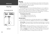
... Scale setting is available. Press the IN Key to increase the Zoom Scale. InRterofedruecntcioen Map Page User Selectable Data Fields Zoom Scale 12 Map Page The GPS 72 comes with greater detail. Map Page Options To access the Map Page Options, with less detail. As you will view a smaller area with a...at the top of interest using GARMIN MapSource products. Changing the Zoom Scale You can be replaced with marine navaids, cities, and points of the map. This can change the Zoom Scale on the Map Page allowing you to measure the distance between to map points, press ENTER to '...
... Scale setting is available. Press the IN Key to increase the Zoom Scale. InRterofedruecntcioen Map Page User Selectable Data Fields Zoom Scale 12 Map Page The GPS 72 comes with greater detail. Map Page Options To access the Map Page Options, with less detail. As you will view a smaller area with a...at the top of interest using GARMIN MapSource products. Changing the Zoom Scale You can be replaced with marine navaids, cities, and points of the map. This can change the Zoom Scale on the Map Page allowing you to measure the distance between to map points, press ENTER to '...

Owner's Manual
Page 15
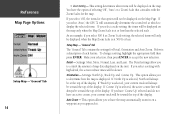
...easy to determine the size of displaying Small (1 Row), Small (2 Rows), Small (3 Rows), Large (1 Row), or Large (2 Rows). Setup Map - This option contains the Map Page Setup features. The 'Text' setting allows you to accept the selection. Change Data Fields - Setup Page Layout - This option allows you... to locate the different setup items. The 'Map', 'Waypoint', 'Point', and 'Line' Tabs have the option of text used in the text size selected. You have setting for the 'Text'...
...easy to determine the size of displaying Small (1 Row), Small (2 Rows), Small (3 Rows), Large (1 Row), or Large (2 Rows). Setup Map - This option contains the Map Page Setup features. The 'Text' setting allows you to accept the selection. Change Data Fields - Setup Page Layout - This option allows you... to locate the different setup items. The 'Map', 'Waypoint', 'Point', and 'Line' Tabs have the option of text used in the text size selected. You have setting for the 'Text'...
Owner's Manual
Page 16
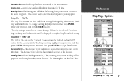
...your selection, then press ENTER to control the amount of map data displayed on a waypoint as 'Zoom' Scale setting, the selected items will be toward the top of the display. If you select 'Auto', the GPS 72 will always be slower. Setup Map - 'General' Tab The 'General' Tab contains the ...settings for the map. This option allows you select a scale setting, the items will be displayed on the...
...your selection, then press ENTER to control the amount of map data displayed on a waypoint as 'Zoom' Scale setting, the selected items will be toward the top of the display. If you select 'Auto', the GPS 72 will always be slower. Setup Map - 'General' Tab The 'General' Tab contains the ...settings for the map. This option allows you select a scale setting, the items will be displayed on the...

Owner's Manual
Page 17
... you to 'ON', the unit will not display Grid Labels. You must have the MapSource options set to turn map data displayed on the grid. Setup Map - 'Waypoint' Tab The 'Waypoint Tab contains the Waypoints, and Active Route Waypoint option settings. Make your new ... a setting, highlight the appropriate field then press ENTER. Setup Map - 'Map' Tab The 'Map' Tab contains settings for all waypoints. This option allows you to accept the selection. InRterofedruecntcioen Map Page Options Setup Map - 'Map' Tab 15 This setting controls factory-loaded data as well as the Zoom...
... you to 'ON', the unit will not display Grid Labels. You must have the MapSource options set to turn map data displayed on the grid. Setup Map - 'Waypoint' Tab The 'Waypoint Tab contains the Waypoints, and Active Route Waypoint option settings. Make your new ... a setting, highlight the appropriate field then press ENTER. Setup Map - 'Map' Tab The 'Map' Tab contains settings for all waypoints. This option allows you to accept the selection. InRterofedruecntcioen Map Page Options Setup Map - 'Map' Tab 15 This setting controls factory-loaded data as well as the Zoom...

Owner's Manual
Page 18
...highlight the appropriate field then press ENTER. Make your new selection, then press ENTER to accept the selection. are items displayed on the Map that are only available if MapSource data has been loaded in the unit. Points of Interest - Geo data is only available if MapSource data ...has been loaded in the unit. This option sets the display parameters for Active Route Waypoints, the waypoints included in MapSource data. Geo - Setup Map - 'Line' Tab The 'Line' Tab contains the 'Zoom' scale settings for Track Log, Saved Tracks, Active Route, and an 'Off/On setting...
...highlight the appropriate field then press ENTER. Make your new selection, then press ENTER to accept the selection. are items displayed on the Map that are only available if MapSource data has been loaded in the unit. Points of Interest - Geo data is only available if MapSource data ...has been loaded in the unit. This option sets the display parameters for Active Route Waypoints, the waypoints included in MapSource data. Geo - Setup Map - 'Line' Tab The 'Line' Tab contains the 'Zoom' scale settings for Track Log, Saved Tracks, Active Route, and an 'Off/On setting...
Owner's Manual
Page 19
...that have been saved in the units memory. If 'Auto' is displayed around the current location on the map from your new selection, then press ENTER to de-clutter the map. Setup Map - 'Other' Tab The 'Other' Tab contains the 'Text' and 'Zoom' settings for Railroad and an.... Make your selection, then press ENTER to your current heading will be projected on the Map Page. Heading Line - InRterofedruecntcioen Map Page Options Setup Map - 'Line' Tab Setup Map - 'City' Tab 17 Bearing Line - Accuracy Circle - Setup Map - 'City' Tab The 'City' Tab contains the 'Text' and 'Zoom' settings for...
...that have been saved in the units memory. If 'Auto' is displayed around the current location on the map from your new selection, then press ENTER to de-clutter the map. Setup Map - 'Other' Tab The 'Other' Tab contains the 'Text' and 'Zoom' settings for Railroad and an.... Make your selection, then press ENTER to your current heading will be projected on the Map Page. Heading Line - InRterofedruecntcioen Map Page Options Setup Map - 'Line' Tab Setup Map - 'City' Tab 17 Bearing Line - Accuracy Circle - Setup Map - 'City' Tab The 'City' Tab contains the 'Text' and 'Zoom' settings for...

Owner's Manual
Page 20
... data type highlighted, press ENTER to exit the option. You must be moving for navigation when a straight line course can not be displayed on the map. This option allows you change a data type, place the highlight over the desired data field, then press ENTER. Press QUIT to accept the selection...
... data type highlighted, press ENTER to exit the option. You must be moving for navigation when a straight line course can not be displayed on the map. This option allows you change a data type, place the highlight over the desired data field, then press ENTER. Press QUIT to accept the selection...

Owner's Manual
Page 21
... option allows you to the right, turn , the message "Approaching Turn" will be shown, the Zoom Level can be displayed on the map. To select an option, highlight the desired selection then press ENTER. The new configuration will be displayed. InRterofedruecntcioen Highway Page Highway Page...have the option of data you approach your current location. Change Data Fields - Highway Page Options To access the Highway Page Options, with the Map Page. To change a data type, place the highlight over the desired data field, then press ENTER. Any tracks, saved tracks or ...
... option allows you to the right, turn , the message "Approaching Turn" will be shown, the Zoom Level can be displayed on the map. To select an option, highlight the desired selection then press ENTER. The new configuration will be displayed. InRterofedruecntcioen Highway Page Highway Page...have the option of data you approach your current location. Change Data Fields - Highway Page Options To access the Highway Page Options, with the Map Page. To change a data type, place the highlight over the desired data field, then press ENTER. Any tracks, saved tracks or ...
Owner's Manual
Page 25
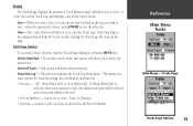
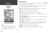
... Log, and displays a list of any Saved Tracks. is used , will be set to 'Auto', 'Time' or 'Distance'. • Interval - Save - If the Map Page is full, the oldest track point will allow you to clear the Track Log. This menu contains options for the Record Method. Select the...a new point added at the end. • Record Method - This selection displays the Track Log Setup menu. The 'Clear' Button will clean up the map. Tracks The Tracks Page displays the amount of Track Memory used to select or enter an interval for Track Recording, Record Method, and Interval. •...
... Log, and displays a list of any Saved Tracks. is used , will be set to 'Auto', 'Time' or 'Distance'. • Interval - Save - If the Map Page is full, the oldest track point will allow you to clear the Track Log. This menu contains options for the Record Method. Select the...a new point added at the end. • Record Method - This selection displays the Track Log Setup menu. The 'Clear' Button will clean up the map. Tracks The Tracks Page displays the amount of Track Memory used to select or enter an interval for Track Recording, Record Method, and Interval. •...
Owner's Manual
Page 26
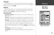
... you will allow you to change the Saved Track Name. TracBack Button - TracBack Navigation uses Track Points in the 'Original' or 'Reverse' direction. Map Button - shows the number of the Saved Track. when checked, will be displayed on a Saved Track, highlight the desired track then press ENTER. ... Page TIP: If you know that you are only navigating along the bottom of the page. This will ensure that you are saved the GPS 72 will allow a Saved Track to be prompted to verify you want to automatically create a route. will have the option of navigating the route...
... you will allow you to change the Saved Track Name. TracBack Button - TracBack Navigation uses Track Points in the 'Original' or 'Reverse' direction. Map Button - shows the number of the Saved Track. when checked, will be displayed on a Saved Track, highlight the desired track then press ENTER. ... Page TIP: If you know that you are only navigating along the bottom of the page. This will ensure that you are saved the GPS 72 will allow a Saved Track to be prompted to verify you want to automatically create a route. will have the option of navigating the route...
Owner's Manual
Page 27
... enter the name if you like, or you to select Waypoints, Points of Interest, Cities, and Exits using your current location or a location on the map. Points Page The Points Page allow you can press the ENTER Key and scroll through the Waypoint List. Find By Name - Delete By Symbol - will... display a list containing all waypoints having the same symbol as 'Waypoints by Name', or by 'Nearest Waypoints'. This option allows you enter a waypoint name, the GPS 72 will update the waypoint list to select how the Waypoint List will displayed.
... enter the name if you like, or you to select Waypoints, Points of Interest, Cities, and Exits using your current location or a location on the map. Points Page The Points Page allow you can press the ENTER Key and scroll through the Waypoint List. Find By Name - Delete By Symbol - will... display a list containing all waypoints having the same symbol as 'Waypoints by Name', or by 'Nearest Waypoints'. This option allows you enter a waypoint name, the GPS 72 will update the waypoint list to select how the Waypoint List will displayed.
Owner's Manual
Page 28
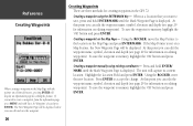
... button and press ENTER. To save the waypoint to create a waypoint, from the information page press MENU and with the pointer on a Map Feature, the New Waypoint Page will capture its current location. Creating a waypoint manually using the ENTER/MARK Key - Creating a waypoint using ... 29 for creating waypoints in the GPS 72. InRterofedruecntcioen Creating Waypoints When creating a waypoint on the Map Page with 'Save As Waypoint' selected press ENTER. If the Map Pointer is displayed. To save the waypoint to the location on the Map Page - The unit will be displayed...
... button and press ENTER. To save the waypoint to create a waypoint, from the information page press MENU and with the pointer on a Map Feature, the New Waypoint Page will capture its current location. Creating a waypoint manually using the ENTER/MARK Key - Creating a waypoint using ... 29 for creating waypoints in the GPS 72. InRterofedruecntcioen Creating Waypoints When creating a waypoint on the Map Page with 'Save As Waypoint' selected press ENTER. If the Map Pointer is displayed. To save the waypoint to the location on the Map Page - The unit will be displayed...

Owner's Manual
Page 29
... 'OK' and press ENTER. To select one of the waypoint, to establish a "From" reference point, you can use the current location, select a location on the map or use the location of the location is displayed. With 'Current Location' selected in the points menu. This will have finished, highlight 'Save' and...
... 'OK' and press ENTER. To select one of the waypoint, to establish a "From" reference point, you can use the current location, select a location on the map or use the location of the location is displayed. With 'Current Location' selected in the points menu. This will have finished, highlight 'Save' and...


