
Owner's Manual
Page 4
... accept any user-serviceable parts. When in actual use, carefully compare indications from the GPS 48 to all aspects of unsafe operation, carefully review and understand all available navigation sources including the information from other NAVAIDs, visual sightings, maps..., etc. Although the GPS 48 is a precision electronic NAVigation AID (NAVAID), any discrepancies before continuing navigation. Operation is...
... accept any user-serviceable parts. When in actual use, carefully compare indications from the GPS 48 to all aspects of unsafe operation, carefully review and understand all available navigation sources including the information from other NAVAIDs, visual sightings, maps..., etc. Although the GPS 48 is a precision electronic NAVigation AID (NAVAID), any discrepancies before continuing navigation. Operation is...
Owner's Manual
Page 6
.... Almanac data must be helpful to review the basic terms and concepts briefly explained below. Course To Steer (CTS) The bearing giving the most efficient direction to your arrival at a destination. 2 INTRODUCTION Glossary The GPS 48 is transmitted to your receiver from every GPS satellite. Other navigation and GPS definitions used in the manual are...
.... Almanac data must be helpful to review the basic terms and concepts briefly explained below. Course To Steer (CTS) The bearing giving the most efficient direction to your arrival at a destination. 2 INTRODUCTION Glossary The GPS 48 is transmitted to your receiver from every GPS satellite. Other navigation and GPS definitions used in the manual are...
Owner's Manual
Page 26
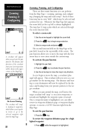
... move the map, a crosshair (plus sign) will now serve as a target marker for a highlighted waypoint: 1. The pan function allows you can either review its own "field", which allows you begin range selection. 3. Press the E key to the target crosshair. As you to quickly... in any direction. zooming, panning, and configuring (changing the map and track setup). To select a zoom scale: 1. Highlight the pan field. 2. To review the waypoint definition page for the moving map. Press the Q key. The distance and direction of the Map Page. Once a waypoint name is highlighted.
... move the map, a crosshair (plus sign) will now serve as a target marker for a highlighted waypoint: 1. The pan function allows you can either review its own "field", which allows you begin range selection. 3. Press the E key to the target crosshair. As you to quickly... in any direction. zooming, panning, and configuring (changing the map and track setup). To select a zoom scale: 1. Highlight the pan field. 2. To review the waypoint definition page for the moving map. Press the Q key. The distance and direction of the Map Page. Once a waypoint name is highlighted.
Owner's Manual
Page 37
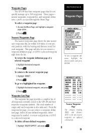
... Press E. To delete all user-defined waypoints, delete waypoints by symbol, or review and perform a GOTO to a selected waypoint. Press E. To review the waypoint definition page of all waypoints currently stored in the GPS 48 and their respective waypoint symbols. To return to a highlighted list waypoint: 1.... waypoint submenu, highlight the desired option and press ENTER. Press E. To go to the nearest waypoint page: 1. Waypoint Pages The GPS 48 has three waypoint pages that are updated continuously. 33 These pages- Nearest Waypoints Page The compass heading (BRG) and distance (DST)...
... Press E. To delete all user-defined waypoints, delete waypoints by symbol, or review and perform a GOTO to a selected waypoint. Press E. To review the waypoint definition page of all waypoints currently stored in the GPS 48 and their respective waypoint symbols. To return to a highlighted list waypoint: 1.... waypoint submenu, highlight the desired option and press ENTER. Press E. To go to the nearest waypoint page: 1. Waypoint Pages The GPS 48 has three waypoint pages that are updated continuously. 33 These pages- Nearest Waypoints Page The compass heading (BRG) and distance (DST)...
Owner's Manual
Page 38
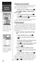
... waypoints. Use the U or D key to select a proximity waypoint and press E. 2. The distance (DST) field will reappear with the waypoint removed. To review or remove a proximity waypoint: 1. Proximity Waypoints The GPS 48's proximity waypoint function warns you when you . Highlight 'PROXIMITY WPTS' and press E. 2. Enter the desired distance. 5. If 'REMOVE?' Highlight the first...
... waypoints. Use the U or D key to select a proximity waypoint and press E. 2. The distance (DST) field will reappear with the waypoint removed. To review or remove a proximity waypoint: 1. Proximity Waypoints The GPS 48's proximity waypoint function warns you when you . Highlight 'PROXIMITY WPTS' and press E. 2. Enter the desired distance. 5. If 'REMOVE?' Highlight the first...
Owner's Manual
Page 39
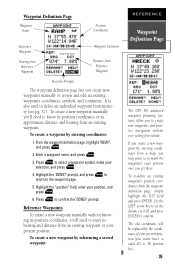
... re-mark the waypoint's exact position once you create a new waypoint by referencing a stored waypoint: REFERENCE Waypoint Definition Page The GPS 48's advanced waypoint planning features allow you must have a valid 2D or 3D position fix). 35 Reference Waypoints To create a new ...page lets you 'll need to create new waypoints and practice navigation without knowing its position coordinates, you create new waypoints manually or review and edit an existing waypoint's coordinates, symbols, and comments. prompt. From the waypoint definition page, highlight 'NEW?', and press ...
... re-mark the waypoint's exact position once you create a new waypoint by referencing a stored waypoint: REFERENCE Waypoint Definition Page The GPS 48's advanced waypoint planning features allow you must have a valid 2D or 3D position fix). 35 Reference Waypoints To create a new ...page lets you 'll need to create new waypoints and practice navigation without knowing its position coordinates, you create new waypoints manually or review and edit an existing waypoint's coordinates, symbols, and comments. prompt. From the waypoint definition page, highlight 'NEW?', and press ...
Owner's Manual
Page 49
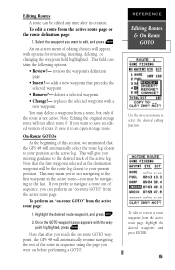
... the selected waypoint with options for reviewing, inserting, deleting, or changing the waypoint field highlighted. Note: Editing the original storage route will automatically resume navigating the rest of the route in the active route-you reach the on-route GOTO waypoint, the GPS 48 will not affect route 0. This ...but only if the route is not active. An on-screen menu of route 0, save it to the last. adds a new waypoint that the GPS 48 will be navigating to an open storage route. point highlighted, press E. To edit a route from the active route page, highlight the desired waypoint...
... the selected waypoint with options for reviewing, inserting, deleting, or changing the waypoint field highlighted. Note: Editing the original storage route will automatically resume navigating the rest of the route in the active route-you reach the on-route GOTO waypoint, the GPS 48 will not affect route 0. This ...but only if the route is not active. An on-screen menu of route 0, save it to the last. adds a new waypoint that the GPS 48 will be navigating to an open storage route. point highlighted, press E. To edit a route from the active route page, highlight the desired waypoint...
Owner's Manual
Page 50
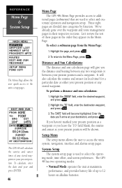
...at your present position. The GPS 48 will calculate the sunrise and sunset times of any stored waypoint. These eight pages are used to select and customize operation and navigation setup. Highlight the 'TO' field, enter the destination waypoint, and press E. 3. Let's review the rest of up to access... the operating mode, time offset, and screen preferences. To calculate, enter the date and year and press ENTER. 46 Menu Page The GPS 48's Menu Page provides access to additional pages (submenus) that are divided into categories by function. We've already gone over the waypoint and...
...at your present position. The GPS 48 will calculate the sunrise and sunset times of any stored waypoint. These eight pages are used to select and customize operation and navigation setup. Highlight the 'TO' field, enter the destination waypoint, and press E. 3. Let's review the rest of up to access... the operating mode, time offset, and screen preferences. To calculate, enter the date and year and press ENTER. 46 Menu Page The GPS 48's Menu Page provides access to additional pages (submenus) that are divided into categories by function. We've already gone over the waypoint and...