
Pilots Guide
Page 2
...Tel: 886/02.2642.9199 Fax: 886/02.2642.9099 www.garmin.com Except as expressly provided herein, no part of this manual may be viewed for any purpose without the express permission of Garmin. Garmin® and G600™ are trademarks of XM Satellite Radio, Inc. or its ...subsidiaries. July 2008 Printed in this manual to download a single copy of this ...
...Tel: 886/02.2642.9199 Fax: 886/02.2642.9099 www.garmin.com Except as expressly provided herein, no part of this manual may be viewed for any purpose without the express permission of Garmin. Garmin® and G600™ are trademarks of XM Satellite Radio, Inc. or its ...subsidiaries. July 2008 Printed in this manual to download a single copy of this ...

Pilots Guide
Page 5
...operation prior to actual use the GDU 620 to attempt to changes which could affect the accuracy and performance of the Garmin GDU 620 utilize GPS as a precision electronic NAVigation AID (NAVAID). During flight operations, carefully compare indications from the GDU...Manual (AIM) recommend avoiding "by at least 20 miles any discrepancies before continuing navigation. Weather information provided by the GDU 620 can be used for long-range planning purposes only. For safety purposes, always resolve any thunderstorm identified as with all aspects of the G600 Pilot's Guide. B Garmin G600...
...operation prior to actual use the GDU 620 to attempt to changes which could affect the accuracy and performance of the Garmin GDU 620 utilize GPS as a precision electronic NAVigation AID (NAVAID). During flight operations, carefully compare indications from the GDU...Manual (AIM) recommend avoiding "by at least 20 miles any discrepancies before continuing navigation. Weather information provided by the GDU 620 can be used for long-range planning purposes only. For safety purposes, always resolve any thunderstorm identified as with all aspects of the G600 Pilot's Guide. B Garmin G600...
Pilots Guide
Page 27
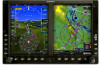
... test features that no databases have expired), the pilot is only updated once every five years. B Garmin G600 Pilot's Guide 1-13 Sec 7 Symbols Sec 8 Glossary Appendix A Appendix B Index 1.2 System Power Up Foreword NOTE: See the Aircraft Flight Manual (AFM) for currency (to ensure that exercise the processor, memory, external inputs, and outputs to... system and receives power directly from electrical busses. Upon power-up . The AHRS can align itself both power-on the GDU 620 display bezels. The G600 System is part of the Navigation Database.
... test features that no databases have expired), the pilot is only updated once every five years. B Garmin G600 Pilot's Guide 1-13 Sec 7 Symbols Sec 8 Glossary Appendix A Appendix B Index 1.2 System Power Up Foreword NOTE: See the Aircraft Flight Manual (AFM) for currency (to ensure that exercise the processor, memory, external inputs, and outputs to... system and receives power directly from electrical busses. Upon power-up . The AHRS can align itself both power-on the GDU 620 display bezels. The G600 System is part of the Navigation Database.

Pilots Guide
Page 33
B Garmin G600 Pilot's Guide 1-19 Appendix B Index Photocell calibration curves are pre-configured to optimize display appearance through a broad range of the PFD and MFD displays and ... bus or the following information is always synchronized between both GDU 620's: • Selected Altitude • Selected Heading • Selected Course 190-00601-02 Rev. Manual backlighting adjustment can be set up to select the desired brightness Level and then press ENTER. The default setting (automatic backlighting adjustment) uses photocell technology...
B Garmin G600 Pilot's Guide 1-19 Appendix B Index Photocell calibration curves are pre-configured to optimize display appearance through a broad range of the PFD and MFD displays and ... bus or the following information is always synchronized between both GDU 620's: • Selected Altitude • Selected Heading • Selected Course 190-00601-02 Rev. Manual backlighting adjustment can be set up to select the desired brightness Level and then press ENTER. The default setting (automatic backlighting adjustment) uses photocell technology...

Pilots Guide
Page 73
... Sec 6 Annun. & Alerts Sec 7 Symbols Sec 8 Glossary Appendix A Appendix B Index Figure 3-17 Navigation Map Auto Zoom 3) Press ENT to select On or Off. B Garmin G600 Pilot's Guide 3-15 With the Map Group active, turn the large MFD knob to the next option. 190-00601-02 Rev. With "Map Setup" highlighted...the aircraft transitions from "on ground" to the next waypoint in the flight plan. The next option will be overridden at any time by manually zooming with the RNG keys or enabling OBS mode. Auto Zoom can be highlighted. 4) Press the small MFD knob to cancel selection or ...
... Sec 6 Annun. & Alerts Sec 7 Symbols Sec 8 Glossary Appendix A Appendix B Index Figure 3-17 Navigation Map Auto Zoom 3) Press ENT to select On or Off. B Garmin G600 Pilot's Guide 3-15 With the Map Group active, turn the large MFD knob to the next option. 190-00601-02 Rev. With "Map Setup" highlighted...the aircraft transitions from "on ground" to the next waypoint in the flight plan. The next option will be overridden at any time by manually zooming with the RNG keys or enabling OBS mode. Auto Zoom can be highlighted. 4) Press the small MFD knob to cancel selection or ...

Pilots Guide
Page 105
...Sec 2 PFD Sec 3 MFD Sec 4 Hazard Avoidance Features 1) While viewing the Aux mode System Setup page, press the MENU key. The manual mode allows the setting of display brightness between 0 and 100%. 1) Turn the large MFD knob to select the Display Brightness Level and then...Annun. & Alerts Sec 7 Symbols Sec 8 Glossary Appendix A Appendix B Index Figure 3-60 Aux Mode Display Brightness Mode Selection 190-00601-02 Rev. B Garmin G600 Pilot's Guide 3-47 Figure 3-58 Aux Mode System Setup Page Menu 2) Turn the large or small MFD knobs to highlight the desired selection and then...
...Sec 2 PFD Sec 3 MFD Sec 4 Hazard Avoidance Features 1) While viewing the Aux mode System Setup page, press the MENU key. The manual mode allows the setting of display brightness between 0 and 100%. 1) Turn the large MFD knob to select the Display Brightness Level and then...Annun. & Alerts Sec 7 Symbols Sec 8 Glossary Appendix A Appendix B Index Figure 3-60 Aux Mode Display Brightness Mode Selection 190-00601-02 Rev. B Garmin G600 Pilot's Guide 3-47 Figure 3-58 Aux Mode System Setup Page Menu 2) Turn the large or small MFD knobs to highlight the desired selection and then...

Pilots Guide
Page 144
... Features Avoidance Hazard Sec 4 Additional Sec 5 & Alerts Annun. Sec 6 Symbols Sec 7 Appendix A Glossary Sec 8 Index Appendix B 4-18 Garmin G600 Pilot's Guide 190-00601-02 Rev. TIS should not be used as a direct result of these limitations are inherent in VMC. TIS is ... and does not relieve the pilot of the Aeronautical Information Manual, Section 1-3-5. TIS relies on TIS Limitations is no better than that must be no visual contact with operating transponders installed. Garmin recommends the user review the TIS Limitations section of responsibility to...
... Features Avoidance Hazard Sec 4 Additional Sec 5 & Alerts Annun. Sec 6 Symbols Sec 7 Appendix A Glossary Sec 8 Index Appendix B 4-18 Garmin G600 Pilot's Guide 190-00601-02 Rev. TIS should not be used as a direct result of these limitations are inherent in VMC. TIS is ... and does not relieve the pilot of the Aeronautical Information Manual, Section 1-3-5. TIS relies on TIS Limitations is no better than that must be no visual contact with operating transponders installed. Garmin recommends the user review the TIS Limitations section of responsibility to...

Pilots Guide
Page 145
... a few radar scans once the course has stabilized. In order to the Aeronautical Information Manual for Mode S geographical coverage. intruder distance and altitude will cause this algorithm to their expected positions consistent with the time of the FAA. B Garmin G600 Pilot's Guide 4-19 Occasionally, aircraft maneuvering will remain relatively accurate and may not...
... a few radar scans once the course has stabilized. In order to the Aeronautical Information Manual for Mode S geographical coverage. intruder distance and altitude will cause this algorithm to their expected positions consistent with the time of the FAA. B Garmin G600 Pilot's Guide 4-19 Occasionally, aircraft maneuvering will remain relatively accurate and may not...

Pilots Guide
Page 147
The mode can be changed manually using soft keys or the page menu. Once the aircraft is airborne, TIS switches to Operating... Icon (Traffic Map Page) (Other Maps) TIS Operating OPERATING TIS Standby STANDBY (Also shown in white in the air. B Garmin G600 Pilot's Guide 4-21 Foreword 4.3.5 TIS System Status The GDU 620 performs an automatic test of TIS during power-up test, an...* The transponder has failed UNAVAILABLE TIS is unavailable or out of range * Contact a service center or Garmin dealer for display on the ground or Operating Mode in center of the Traffic Map Page.
The mode can be changed manually using soft keys or the page menu. Once the aircraft is airborne, TIS switches to Operating... Icon (Traffic Map Page) (Other Maps) TIS Operating OPERATING TIS Standby STANDBY (Also shown in white in the air. B Garmin G600 Pilot's Guide 4-21 Foreword 4.3.5 TIS System Status The GDU 620 performs an automatic test of TIS during power-up test, an...* The transponder has failed UNAVAILABLE TIS is unavailable or out of range * Contact a service center or Garmin dealer for display on the ground or Operating Mode in center of the Traffic Map Page.

Pilots Guide
Page 171
... intervals manually. Sec 2 PFD Sec 3 MFD Sec 4 Hazard Avoidance Features Sec 5 Additional Sec 6 Annun. & Alerts Sec 7 Symbols Sec 8 Glossary Appendix A Figure 4-30 XM Weather - A blue line with a large H or L. Forecasts are displayed only within the installed Aviation Database service area. High and Low pressure centers are moving. Figure 4-31 XM Weather - B Garmin G600...
... intervals manually. Sec 2 PFD Sec 3 MFD Sec 4 Hazard Avoidance Features Sec 5 Additional Sec 6 Annun. & Alerts Sec 7 Symbols Sec 8 Glossary Appendix A Figure 4-30 XM Weather - A blue line with a large H or L. Forecasts are displayed only within the installed Aviation Database service area. High and Low pressure centers are moving. Figure 4-31 XM Weather - B Garmin G600...

Pilots Guide
Page 205
... autopilot controller. 190-00601-02 Rev. At the set the desired heading. Foreword Sec 1 System Sec 2 PFD 5.6 Autopilot Operation The G600 is able to interface to certain autopilot systems to an Altitude Capture mode where it will hold mode. 3) Continue to set altitude, the... select the desired vertical speed (if able) on the GDU 620 by adjusting the heading bug. B Garmin G600 Pilot's Guide 5-25 Appendix B Index Please refer to your particular autopilot manual for three seconds after the knob stops moving. 2) Engage your selected autopilot heading with the autopilot.
... autopilot controller. 190-00601-02 Rev. At the set the desired heading. Foreword Sec 1 System Sec 2 PFD 5.6 Autopilot Operation The G600 is able to interface to certain autopilot systems to an Altitude Capture mode where it will hold mode. 3) Continue to set altitude, the... select the desired vertical speed (if able) on the GDU 620 by adjusting the heading bug. B Garmin G600 Pilot's Guide 5-25 Appendix B Index Please refer to your particular autopilot manual for three seconds after the knob stops moving. 2) Engage your selected autopilot heading with the autopilot.

Pilots Guide
Page 223
...Garmin G600 Pilot's Guide 8-1 Foreword Sec 1 System Sec 2 PFD Sec 3 MFD 8 Glossary ACT, ACTV ADC ADF ADI AFM AFMS AGL AHRS AIM AIRMET ALT AP APR APT ARINC ARSPC ARTCC AS ASOS ATC ATCRBS ATIS AUX AWOS active, activate Air Data Computer Automatic Direction Finder Attitude Direction Indicator Airplane Flight Manual Airplane Flight Manual... Supplement Above Ground Level Attitude and Heading Reference System Airman's Information Manual Airman's Meteorological Information altitude autopilot approach ...
...Garmin G600 Pilot's Guide 8-1 Foreword Sec 1 System Sec 2 PFD Sec 3 MFD 8 Glossary ACT, ACTV ADC ADF ADI AFM AFMS AGL AHRS AIM AIRMET ALT AP APR APT ARINC ARSPC ARTCC AS ASOS ATC ATCRBS ATIS AUX AWOS active, activate Air Data Computer Automatic Direction Finder Attitude Direction Indicator Airplane Flight Manual Airplane Flight Manual... Supplement Above Ground Level Attitude and Heading Reference System Airman's Information Manual Airman's Meteorological Information altitude autopilot approach ...


