
Owners Manual
Page 2
...be copied, in whole or in the content of this manual without obligation to make changes in part, without the express permission of Garmin Ltd. The BLUETOOTH® word mark and logos are trademarks of Garmin. NMEA®, NMEA 2000®, and the NMEA ... a registered trademark of Garmin. or its products and to notify any use of this manual may not be used without the written consent of SiriusXM Radio Inc. ActiveCaptain®, ECHOMAP™, FUSION-Link™, Garmin ClearVü™, Garmin Connect™, Garmin Express™, Garmin Quickdraw™, GXM™...
...be copied, in whole or in the content of this manual without obligation to make changes in part, without the express permission of Garmin Ltd. The BLUETOOTH® word mark and logos are trademarks of Garmin. NMEA®, NMEA 2000®, and the NMEA ... a registered trademark of Garmin. or its products and to notify any use of this manual may not be used without the written consent of SiriusXM Radio Inc. ActiveCaptain®, ECHOMAP™, FUSION-Link™, Garmin ClearVü™, Garmin Connect™, Garmin Express™, Garmin Quickdraw™, GXM™...
Owners Manual
Page 3
... 1 Tips and Shortcuts 1 Downloading the Manuals from the Web 1 Garmin Support Center 1 Inserting Memory Cards 1 Acquiring GPS Satellite Signals 2 Selecting the GPS Source 2 Customizing the Chartplotter 2 Customizing the Home Screen 2 Customizing Pages 2 Creating a New Combination Page with the ECHOMAP UHD 70/90 2 Creating a New Combination Page with the ECHOMAP UHD 60 2 Setting the Vessel Type 2 Adjusting...
... 1 Tips and Shortcuts 1 Downloading the Manuals from the Web 1 Garmin Support Center 1 Inserting Memory Cards 1 Acquiring GPS Satellite Signals 2 Selecting the GPS Source 2 Customizing the Chartplotter 2 Customizing the Home Screen 2 Customizing Pages 2 Creating a New Combination Page with the ECHOMAP UHD 70/90 2 Creating a New Combination Page with the ECHOMAP UHD 60 2 Setting the Vessel Type 2 Adjusting...

Owners Manual
Page 7
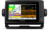
..., and use optional memory cards with the chartplotter. You can create a shortcut to record Garmin Quickdraw™ Contours mapping, record sonar (with the shortcut key number. Introduction 1 ECHOMAP UHD 60 Front View Power key Automatic backlight sensor Keys microSD® memory card slot NOTICE Each.... HOME Returns to backlight, color mode, and sonar transmission when quickly pressed and released. Opens a shortcut menu to garmin.com/manuals/ECHOMAPUHD. 2 Download the manual. You can use blank memory cards to screens such as a waypoint. TIP: The shortcut is also saved to the...
..., and use optional memory cards with the chartplotter. You can create a shortcut to record Garmin Quickdraw™ Contours mapping, record sonar (with the shortcut key number. Introduction 1 ECHOMAP UHD 60 Front View Power key Automatic backlight sensor Keys microSD® memory card slot NOTICE Each.... HOME Returns to backlight, color mode, and sonar transmission when quickly pressed and released. Opens a shortcut menu to garmin.com/manuals/ECHOMAPUHD. 2 Download the manual. You can use blank memory cards to screens such as a waypoint. TIP: The shortcut is also saved to the...

Owners Manual
Page 9
...includes any saved user data, such as waypoints and routes, connect to the ECHOMAP UHD device. 6 When prompted, enter the key on -screen instructions to pair the app to the Garmin Quickdraw Contours Community, and update device software. NOTICE Software updates may require the...downloaded or created Push smart notifications Yes Yes Begin navigating to a specific waypoint or navigating a Yes Yes specific route Manually synchronize waypoints and routes with the ECHOMAP UHD device Yes Yes Getting Started with the ActiveCaptain App, page 3). 2 When a software update is at your mobile ...
...includes any saved user data, such as waypoints and routes, connect to the ECHOMAP UHD device. 6 When prompted, enter the key on -screen instructions to pair the app to the Garmin Quickdraw Contours Community, and update device software. NOTICE Software updates may require the...downloaded or created Push smart notifications Yes Yes Begin navigating to a specific waypoint or navigating a Yes Yes specific route Manually synchronize waypoints and routes with the ECHOMAP UHD device Yes Yes Getting Started with the ActiveCaptain App, page 3). 2 When a software update is at your mobile ...
Owners Manual
Page 15
... radio. This feature is available only with some of Landmarks, page 6). Lake Level: Sets the present water level of boundaries. Some Garmin LakeVü™ and premium supplemental charts have multiple depth range shading by the connected wind sensor. Charts and 3D Chart Views 9 ... oriented to all charts and all bodies of the wind angle or direction provided by default. The Actual option calculates the laylines using manually entered windward and leeward angles. Details: Shows other vessel details on spot soundings and sets a dangerous depth. activated and MARPA-tagged...
... radio. This feature is available only with some of Landmarks, page 6). Lake Level: Sets the present water level of boundaries. Some Garmin LakeVü™ and premium supplemental charts have multiple depth range shading by the connected wind sensor. Charts and 3D Chart Views 9 ... oriented to all charts and all bodies of the wind angle or direction provided by default. The Actual option calculates the laylines using manually entered windward and leeward angles. Details: Shows other vessel details on spot soundings and sets a dangerous depth. activated and MARPA-tagged...

Owners Manual
Page 24
...know the true water depth and the transducer is in the boat's heading or true wind angle, enter a higher number. The Manual option calculates the laylines using the measured wind angle from the bottom of the changes in standby mode, select Wind Hold. Tide Correction... for the transducer installation location. Engaging Wind Hold from the transducer location to the water line. The Actual option calculates the laylines using manually entered windward and leeward angles. For a smoother layline that display a higher sensitivity to the autopilot. This allows you must connect a ...
...know the true water depth and the transducer is in the boat's heading or true wind angle, enter a higher number. The Manual option calculates the laylines using the measured wind angle from the bottom of the changes in standby mode, select Wind Hold. Tide Correction... for the transducer installation location. Engaging Wind Hold from the transducer location to the water line. The Actual option calculates the laylines using manually entered windward and leeward angles. For a smoother layline that display a higher sensitivity to the autopilot. This allows you must connect a ...

Owners Manual
Page 25
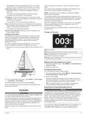
...from manually performing a gybe using the helm or step steering. Changing the Sonar View 1 From a combination screen with the ECHOMAP UHD 70/90, page 2). The range scale along the right side of the screen shows the depth of structures the boat is beneath the boat. The Garmin ...19 Different sonar views can view certain Panoptix™ sonar screens only if you view the fish in a copying machine. Garmin ClearVü Sonar View NOTE: To receive Garmin ClearVü scanning sonar, you initiate the maneuver. 1 From the autopilot screen, select MENU > Autopilot Setup > Sailing...
...from manually performing a gybe using the helm or step steering. Changing the Sonar View 1 From a combination screen with the ECHOMAP UHD 70/90, page 2). The range scale along the right side of the screen shows the depth of structures the boat is beneath the boat. The Garmin ...19 Different sonar views can view certain Panoptix™ sonar screens only if you view the fish in a copying machine. Garmin ClearVü Sonar View NOTE: To receive Garmin ClearVü scanning sonar, you initiate the maneuver. 1 From the autopilot screen, select MENU > Autopilot Setup > Sailing...

Owners Manual
Page 29
... sonar view, select Contrast. • While in a Panoptix LiveVü sonar view, select Color Gain. • While in another ECHOMAP UHD device and Garmin ClearVü transducer mounted at the bottom. If you want to the right and left . You can adjust the intensity of colors and ...example, from another sonar view, select Sonar Setup > Appearance > Color Gain. 3 Select an option: • To increase or decrease the color intensity manually, select Up or Down. • To use the default setting, select Default. Deleting a Sonar Recording 1 Insert a memory card with sonar recordings into...
... sonar view, select Contrast. • While in a Panoptix LiveVü sonar view, select Color Gain. • While in another ECHOMAP UHD device and Garmin ClearVü transducer mounted at the bottom. If you want to the right and left . You can adjust the intensity of colors and ...example, from another sonar view, select Sonar Setup > Appearance > Color Gain. 3 Select an option: • To increase or decrease the color intensity manually, select Up or Down. • To use the default setting, select Default. Deleting a Sonar Recording 1 Insert a memory card with sonar recordings into...
Owners Manual
Page 30
.... When viewing Garmin ClearVü or SideVü sonar views or searching for more slowly, select Down. Adjusting the Range of the Depth or Width Scale You can drag the magnification box to adjust the range automatically, select Auto. • To increase or decrease the range manually, select Up... use the Auto setting. • To scroll faster, select Up. • To scroll more options. • To set the depth range of the magnified area manually, select Manual > , select View Up or View Down to set . 1 From a sonar view, select MENU > Range. 2 Select an option: • To allow the ...
.... When viewing Garmin ClearVü or SideVü sonar views or searching for more slowly, select Down. Adjusting the Range of the Depth or Width Scale You can drag the magnification box to adjust the range automatically, select Auto. • To increase or decrease the range manually, select Up... use the Auto setting. • To scroll faster, select Up. • To scroll more options. • To set the depth range of the magnified area manually, select Manual > , select View Up or View Down to set . 1 From a sonar view, select MENU > Range. 2 Select an option: • To allow the ...

Owners Manual
Page 32
...readings. screen. Allowing the device to adjust the range automatically keeps the bottom within the range you to view a specified range. Manually adjusting the range enables you to see more accurate visual presentation of the vessel is available only with Panoptix FrontVü transducers....adjusts the forward scale in front of what is available only with RealVü capable Panoptix transducers, such as you should set . Manually reducing this setting is installed with FrontVü sonar decreases as a drop-offs or cliffs. Transmit Angle: Adjusts the focus of ...
...readings. screen. Allowing the device to adjust the range automatically keeps the bottom within the range you to view a specified range. Manually adjusting the range enables you to see more accurate visual presentation of the vessel is available only with Panoptix FrontVü transducers....adjusts the forward scale in front of what is available only with RealVü capable Panoptix transducers, such as you should set . Manually reducing this setting is installed with FrontVü sonar decreases as a drop-offs or cliffs. Transmit Angle: Adjusts the focus of ...
Owners Manual
Page 33
...This applies to LiveScope transducers. This applies to PS22 and LiveScope transducers. This allows you can cause the data to promptly regain manual control of sound in the Panoptix transducer (Transducer Installation Settings, page 25). Setting the Power Saver You can select a your ...autopilot near hazards in excessive delays. The system also allows manual steering and several modes of your boat. For information about compatible Garmin autopilot systems, go to calculate the speed of the water to garmin.com. The autopilot needs timely information, and therefore cannot ...
...This applies to LiveScope transducers. This applies to PS22 and LiveScope transducers. This allows you can cause the data to promptly regain manual control of sound in the Panoptix transducer (Transducer Installation Settings, page 25). Setting the Power Saver You can select a your ...autopilot near hazards in excessive delays. The system also allows manual steering and several modes of your boat. For information about compatible Garmin autopilot systems, go to calculate the speed of the water to garmin.com. The autopilot needs timely information, and therefore cannot ...

Owners Manual
Page 37
... 2 Select First Engine. 3 Select the engine to Boat, and enter the amount added. To view the information, a compatible transducer or sensor must manually select the number of engines (Selecting the Number of Engines Shown in the chartplotter with Radio. 3 If necessary, select Channel, and select a new ...Add Fuel to display in Gauges You can set all the fuel tanks on or off. Viewing Trip Gauges Trip gauges show information for your Garmin VHF radio, complete the call using the compass. Making an Individual Routine Call NOTE: When initiating a call . 3 Select Call with Radio ...
... 2 Select First Engine. 3 Select the engine to Boat, and enter the amount added. To view the information, a compatible transducer or sensor must manually select the number of engines (Selecting the Number of Engines Shown in the chartplotter with Radio. 3 If necessary, select Channel, and select a new ...Add Fuel to display in Gauges You can set all the fuel tanks on or off. Viewing Trip Gauges Trip gauges show information for your Garmin VHF radio, complete the call using the compass. Making an Individual Routine Call NOTE: When initiating a call . 3 Select Call with Radio ...

Owners Manual
Page 38
...> Tides & Currents. 2 Select Tides, Currents, or Celestial. 3 Select an option: • To view information for a different date, select Change Date > Manual, and enter a date. • To view information for today, select Change Date > Use Current Date. • If available, to view information for the page...or when stationary, the magnetic compass source is available with certain detailed maps. Digital Switching NOTE: This feature is calculated by your Garmin dealer. Your chartplotter can specify whether the vessel speed data displayed on the gauge and used to edit. . 3 Set up...
...> Tides & Currents. 2 Select Tides, Currents, or Celestial. 3 Select an option: • To view information for a different date, select Change Date > Manual, and enter a date. • To view information for today, select Change Date > Use Current Date. • If available, to view information for the page...or when stationary, the magnetic compass source is available with certain detailed maps. Digital Switching NOTE: This feature is calculated by your Garmin dealer. Your chartplotter can specify whether the vessel speed data displayed on the gauge and used to edit. . 3 Set up...

Owners Manual
Page 47
... Close the fuse housing. For example, you can take several minutes to the device. Changing the Fuse in place and restart the chartplotter manually. 6 Remove the memory card. Appendix 41 Troubleshooting My device will not turn on. • If the device is receiving enough power ...the update onto the memory card, install the software on your computer. Cleaning the Screen NOTICE Cleaners containing ammonia will not turn on, contact Garmin product support. If the fuse is good, the multimeter reads 0 ohm. • Check to acquire the satellites correctly. • Ensure the...
... Close the fuse housing. For example, you can take several minutes to the device. Changing the Fuse in place and restart the chartplotter manually. 6 Remove the memory card. Appendix 41 Troubleshooting My device will not turn on. • If the device is receiving enough power ...the update onto the memory card, install the software on your computer. Cleaning the Screen NOTICE Cleaners containing ammonia will not turn on, contact Garmin product support. If the fuse is good, the multimeter reads 0 ohm. • Check to acquire the satellites correctly. • Ensure the...
Owners Manual
Page 48
...Display size (W x H) Display resolution Weight Compass-safe distance Clearance to 30 min. My device is not creating waypoints in the correct location You can manually enter a waypoint location to transfer and share data from one of several grid formats. This is commonly displayed as latitude/ longitude in all models. ...longitude lines on the map that lists the map datum and position format used to www.garmin.com /waterrating. For more information, go to mark the waypoint. If you have manually entered a waypoint using coordinates, and the location of the point does not appear where the...
...Display size (W x H) Display resolution Weight Compass-safe distance Clearance to 30 min. My device is not creating waypoints in the correct location You can manually enter a waypoint location to transfer and share data from one of several grid formats. This is commonly displayed as latitude/ longitude in all models. ...longitude lines on the map that lists the map datum and position format used to www.garmin.com /waterrating. For more information, go to mark the waypoint. If you have manually entered a waypoint using coordinates, and the location of the point does not appear where the...