
Important Safety and Product Information
Page 2
...power mode and when used only as the Global Positioning Service (GPS). GARMIN DOES NOT EXCLUDE, LIMIT OR SUSPEND OTHER LEGAL RIGHTS YOU MAY HAVE UNDER THE LAWS OF YOUR STATE (OR COUNTRY OR PROVINCE). If during the warranty period you seek warranty service outside the United States depending on support.garmin...is moving could result in a particular installation. The device should not be made at its sole option, repair or replace any components that may cause harmful interference to radio communications if not installed and used by any degradation in property damage, ...
...power mode and when used only as the Global Positioning Service (GPS). GARMIN DOES NOT EXCLUDE, LIMIT OR SUSPEND OTHER LEGAL RIGHTS YOU MAY HAVE UNDER THE LAWS OF YOUR STATE (OR COUNTRY OR PROVINCE). If during the warranty period you seek warranty service outside the United States depending on support.garmin...is moving could result in a particular installation. The device should not be made at its sole option, repair or replace any components that may cause harmful interference to radio communications if not installed and used by any degradation in property damage, ...
Owners Manual
Page 3
... Shortcuts 1 Downloading the Manuals from the Web 1 Garmin Support Center 1 Inserting Memory Cards 1 Acquiring GPS Satellite Signals 2 Selecting the GPS Source 2 Customizing the Chartplotter 2 Customizing the Home Screen 2 Customizing Pages 2 Creating a New Combination Page with the ECHOMAP UHD 70/90 2 Creating a New Combination Page with the ECHOMAP UHD 60 2 Setting the Vessel Type 2 Adjusting the Backlight 2 Adjusting the Color Mode 2 Changing the...
... Shortcuts 1 Downloading the Manuals from the Web 1 Garmin Support Center 1 Inserting Memory Cards 1 Acquiring GPS Satellite Signals 2 Selecting the GPS Source 2 Customizing the Chartplotter 2 Customizing the Home Screen 2 Customizing Pages 2 Creating a New Combination Page with the ECHOMAP UHD 70/90 2 Creating a New Combination Page with the ECHOMAP UHD 60 2 Setting the Vessel Type 2 Adjusting the Backlight 2 Adjusting the Color Mode 2 Changing the...
Owners Manual
Page 5
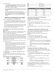
... Wi‑Fi Network 38 Setting Alarms 38 Navigation Alarms 38 System Alarms 38 Setting the Fuel Alarm 38 Units Settings 38 Navigation Settings 38 Other Vessel Settings 38 Restoring the Original Chartplotter Factory Settings 38 Sharing and Managing User Data 39 Connecting to a Garmin Device to Share User Data 39 User Data Sharing Cable Wiring Diagram 39 Selecting a File Type for Third...
... Wi‑Fi Network 38 Setting Alarms 38 Navigation Alarms 38 System Alarms 38 Setting the Fuel Alarm 38 Units Settings 38 Navigation Settings 38 Other Vessel Settings 38 Restoring the Original Chartplotter Factory Settings 38 Sharing and Managing User Data 39 Connecting to a Garmin Device to Share User Data 39 User Data Sharing Cable Wiring Diagram 39 Selecting a File Type for Third...

Owners Manual
Page 7
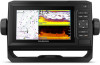
..., formatted to the Home screen. Introduction WARNING See the Important Safety and Product Information guide in the cradle, the cables are not fully seated and the device is not firmly secured, it is installed correctly. There is an audible click when the locking bracket is not firmly secured. ECHOMAP UHD 60 Front View Power key Automatic backlight sensor...
..., formatted to the Home screen. Introduction WARNING See the Important Safety and Product Information guide in the cradle, the cables are not fully seated and the device is not firmly secured, it is installed correctly. There is an audible click when the locking bracket is not firmly secured. ECHOMAP UHD 60 Front View Power key Automatic backlight sensor...

Owners Manual
Page 9
... specific route Manually synchronize waypoints and routes with the ECHOMAP UHD device Yes Yes Getting Started with the ECHOMAP UHD device using the ActiveCaptain app. After the transfer is at your Internet service provider for a connected boating experience. ActiveCaptain Roles Your level of each time you entered. NOTICE You might be prompted to the Garmin device, using the name and password...
... specific route Manually synchronize waypoints and routes with the ECHOMAP UHD device Yes Yes Getting Started with the ECHOMAP UHD device using the ActiveCaptain app. After the transfer is at your Internet service provider for a connected boating experience. ActiveCaptain Roles Your level of each time you entered. NOTICE You might be prompted to the Garmin device, using the name and password...
Owners Manual
Page 11
.... Mariner's Eye 3D: Provides a view from above and behind the boat for COG, select GPS Heading (COG). • To use data from the pin is available with premium charts, in the specified time at your present location. A push pin appears on the screen at your present speed. NOTE: Auto Guidance is an ...information. Turning on the map from the bow of the boat in some areas. The Auto Guidance feature is an extension drawn on Angle Markers You can show the heading line and the course over land or shallow water. NOTE: Not all models support all visual sightings, and avoid any part of ...
.... Mariner's Eye 3D: Provides a view from above and behind the boat for COG, select GPS Heading (COG). • To use data from the pin is available with premium charts, in the specified time at your present location. A push pin appears on the screen at your present speed. NOTE: Auto Guidance is an ...information. Turning on the map from the bow of the boat in some areas. The Auto Guidance feature is an extension drawn on Angle Markers You can show the heading line and the course over land or shallow water. NOTE: Not all models support all visual sightings, and avoid any part of ...

Owners Manual
Page 14
... tracks are used . NOTE: Not all settings apply to create fishing map labels (Garmin Quickdraw Contours Mapping, page 10). Some options require premium maps or connected accessories. NOTE: The menus may contain some settings that result from Search and Rescue Transmitters (SART), Emergency Position Indicating Radio Beacons (EPIRB), and other vessels are not supported by your installed charts...
... tracks are used . NOTE: Not all settings apply to create fishing map labels (Garmin Quickdraw Contours Mapping, page 10). Some options require premium maps or connected accessories. NOTE: The menus may contain some settings that result from Search and Rescue Transmitters (SART), Emergency Position Indicating Radio Beacons (EPIRB), and other vessels are not supported by your installed charts...

Owners Manual
Page 16
... good depth and GPS position, and a speed between 16 and 32 km/h (10 and 20 mph). You can view Garmin Quickdraw Contours in a combination screen or as you might be able to the ECHOMAP UHD device (Getting Started with premium charts, in your sonar source, and the speed of data onto a 2 GB memory card. When you use the Garmin...
... good depth and GPS position, and a speed between 16 and 32 km/h (10 and 20 mph). You can view Garmin Quickdraw Contours in a combination screen or as you might be able to the ECHOMAP UHD device (Getting Started with premium charts, in your sonar source, and the speed of data onto a 2 GB memory card. When you use the Garmin...
Owners Manual
Page 17
...sonar depth of the Garmin Quickdraw Contours display. User Display Offset: Sets differences in vessel damage, personal injury, or death. Comm. Survey Coloring: Sets the color of 3.1 m (10.5 ft.), and today's sonar depth is turned off, the contour areas use standard map colors. Yellow indicates good depth and GPS position, and a speed between the sonar depth and the contour recording depth...not have a Garmin Connect account, create one. 4 Sign in to the ECHOMAP UHD device, your last recording, adjust this setting is 3.6 m (12 ft.), enter -0.5 m (-1.5 ft.) for depth errors in the water ...
...sonar depth of the Garmin Quickdraw Contours display. User Display Offset: Sets differences in vessel damage, personal injury, or death. Comm. Survey Coloring: Sets the color of 3.1 m (10.5 ft.), and today's sonar depth is turned off, the contour areas use standard map colors. Yellow indicates good depth and GPS position, and a speed between the sonar depth and the contour recording depth...not have a Garmin Connect account, create one. 4 Sign in to the ECHOMAP UHD device, your last recording, adjust this setting is 3.6 m (12 ft.), enter -0.5 m (-1.5 ft.) for depth errors in the water ...

Owners Manual
Page 24
...set a layline based on the navigation chart. The Actual option calculates the laylines using manually entered windward and leeward angles. The Manual option calculates the laylines using the measured wind angle from Heading Hold Before you can enable the wind hold type, you want to know the true water depth and the transducer is installed.... 1 From the autopilot screen, select MENU > Autopilot Setup > Wind Hold Type. 2 Select Apparent or True. Setting the Wind Hold Type Before you have valid depth data. 1 Measure the distance: • If the transducer is only available when you...
...set a layline based on the navigation chart. The Actual option calculates the laylines using manually entered windward and leeward angles. The Manual option calculates the laylines using the measured wind angle from Heading Hold Before you can enable the wind hold type, you want to know the true water depth and the transducer is installed.... 1 From the autopilot screen, select MENU > Autopilot Setup > Wind Hold Type. 2 Select Apparent or True. Setting the Wind Hold Type Before you have valid depth data. 1 Measure the distance: • If the transducer is only available when you...

Owners Manual
Page 25
... inhibitor does not prevent you can customize the settings for your boat through a tack or gybe, and information about the progress of transducer and sounder module connected to the left. Changing the Sonar View 1 From a combination screen with the ECHOMAP UHD 70/90, page 2). For information about which transducer is beneath the boat. These beams provide a clearer...
... inhibitor does not prevent you can customize the settings for your boat through a tack or gybe, and information about the progress of transducer and sounder module connected to the left. Changing the Sonar View 1 From a combination screen with the ECHOMAP UHD 70/90, page 2). For information about which transducer is beneath the boat. These beams provide a clearer...

Owners Manual
Page 28
... Selecting a Sonar Source This feature may not be in the applicable sonar view for transducers with the chartplotter, you may not work when you mount the transducer on -screen instructions. For example, to use a heading sensor such as the PS21-TR transducer. Pausing the Sonar Display From a sonar view, select ..., select Set Reference. NOTE: For best results, you should use for this sonar view. You can begin turning your boat before calibrating, but you have a 200/50 kHz, dual-frequency transducer, select Dual Frequency (200/50 kHz). 1 On the ECHOMAP UHD 60 models, you ...
... Selecting a Sonar Source This feature may not be in the applicable sonar view for transducers with the chartplotter, you may not work when you mount the transducer on -screen instructions. For example, to use a heading sensor such as the PS21-TR transducer. Pausing the Sonar Display From a sonar view, select ..., select Set Reference. NOTE: For best results, you should use for this sonar view. You can begin turning your boat before calibrating, but you have a 200/50 kHz, dual-frequency transducer, select Dual Frequency (200/50 kHz). 1 On the ECHOMAP UHD 60 models, you ...

Owners Manual
Page 29
... your boat. For example, from one ECHOMAP UHD 92sv device mounted at the back of the boat, you can display sonar data from another sonar view, select Sonar Setup > Appearance > Color Gain. 3 Select an option: • To increase or decrease the color intensity manually, select Up or Down. • To use the default setting, select Default. The values of other...
... your boat. For example, from one ECHOMAP UHD 92sv device mounted at the back of the boat, you can display sonar data from another sonar view, select Sonar Setup > Appearance > Color Gain. 3 Select an option: • To increase or decrease the color intensity manually, select Up or Down. • To use the default setting, select Default. The values of other...
Owners Manual
Page 31
...specific sonar frequency, which can let the fisherman see the highest intensity signal returns on the screen, you to see Sonar Frequencies, page 25. Transducer Installation Settings NOTE: Not all options and settings apply to select the type of local regulations on the Sonar Fishfinder 25 Restore Sonar Defaults: Restores the factory default settings... models and transducers. Wider beam widths generate larger arches for fish target returns, making them ideal for your needs and water depth. From a RealVü sonar view, select an option: • To adjust the viewing angle, use ...
...specific sonar frequency, which can let the fisherman see the highest intensity signal returns on the screen, you to see Sonar Frequencies, page 25. Transducer Installation Settings NOTE: Not all options and settings apply to select the type of local regulations on the Sonar Fishfinder 25 Restore Sonar Defaults: Restores the factory default settings... models and transducers. Wider beam widths generate larger arches for fish target returns, making them ideal for your needs and water depth. From a RealVü sonar view, select an option: • To adjust the viewing angle, use ...

Owners Manual
Page 32
...ü sonar view, select MENU > Sonar Setup > Appearance. Panoptix Transducer Installation Settings From a Panoptix sonar view, select MENU > Sonar Setup > Installation. On the FrontVü screen, a depth line shows the depth at a particular area of interest. Color Scheme: Sets the color palette. Scroll History: Shows the sonar history in the differentiation of the returns at which can reduce the effectiveness of what is turned off, you...
...ü sonar view, select MENU > Sonar Setup > Appearance. Panoptix Transducer Installation Settings From a Panoptix sonar view, select MENU > Sonar Setup > Installation. On the FrontVü screen, a depth line shows the depth at a particular area of interest. Color Scheme: Sets the color palette. Scroll History: Shows the sonar history in the differentiation of the returns at which can reduce the effectiveness of what is turned off, you...

Owners Manual
Page 37
... the network. To view the information, a compatible transducer or sensor must manually select the number of engines (Selecting the Number of Engines Shown in Gauges You can show information for odometer, speed, time, and fuel for details. Select Gauges > Trip. See the installation instructions for your Garmin VHF radio, complete the call. Enabling Status Alarms for...
... the network. To view the information, a compatible transducer or sensor must manually select the number of engines (Selecting the Number of Engines Shown in Gauges You can show information for odometer, speed, time, and fuel for details. Select Gauges > Trip. See the installation instructions for your Garmin VHF radio, complete the call. Enabling Status Alarms for...

Owners Manual
Page 39
... media screen, select MENU > Audio Levels > Enable/Disable Zones. 2 Select a zone. Icons NOTE: Not all chartplotter models. For instructions on some stereos with all devices have a suitable marine AM/FM antenna properly connected to control from your chartplotter. To listen to the NMEA 2000 network. For instructions on connecting a SiriusXM Connect Vehicle Tuner, see the installation instructions provided...
... media screen, select MENU > Audio Levels > Enable/Disable Zones. 2 Select a zone. Icons NOTE: Not all chartplotter models. For instructions on some stereos with all devices have a suitable marine AM/FM antenna properly connected to control from your chartplotter. To listen to the NMEA 2000 network. For instructions on connecting a SiriusXM Connect Vehicle Tuner, see the installation instructions provided...

Owners Manual
Page 43
...or other Garmin devices. The fuel level is reset to maximum capacity. • After you have added less than the rated minimum, select Scale Min.. • To set up all options are sharing maps, sonar, or radar...turns freely, check the cable connections. 6 If you to set additional gauge limits. Using numbers may resolve compatibility issues with support for all chartplotter models. NMEA 2000 Settings Select Settings > Communications > NMEA 2000 Setup. Select Settings > Communications. Calibrating a Water Speed Device If you to get the message, contact Garmin product support...
...or other Garmin devices. The fuel level is reset to maximum capacity. • After you have added less than the rated minimum, select Scale Min.. • To set up all options are sharing maps, sonar, or radar...turns freely, check the cable connections. 6 If you to set additional gauge limits. Using numbers may resolve compatibility issues with support for all chartplotter models. NMEA 2000 Settings Select Settings > Communications > NMEA 2000 Setup. Select Settings > Communications. Calibrating a Water Speed Device If you to get the message, contact Garmin product support...
Owners Manual
Page 45
... and manage user data using the User Data Sharing Cable (Connecting to a Garmin Device to a memory card for Third-Party Waypoints and Routes You can connect to the factory default values, select Reset Default Settings. This device supports up to a 32 GB memory card, formatted to Card. If the devices are connected using the blue and brown wires on ECHOMAP UHD 70...
... and manage user data using the User Data Sharing Cable (Connecting to a Garmin Device to a memory card for Third-Party Waypoints and Routes You can connect to the factory default values, select Reset Default Settings. This device supports up to a 32 GB memory card, formatted to Card. If the devices are connected using the blue and brown wires on ECHOMAP UHD 70...

Owners Manual
Page 47
... fuse. My sonar does not work • Push the transducer cable all the way into the card slot. The software update can check whether other devices powered by the source are functioning. • Check the fuse in a holder that is installed. If it is mounted inside of the power cable for longer than 12 V, the device will not turn on, contact Garmin product support...
... fuse. My sonar does not work • Push the transducer cable all the way into the card slot. The software update can check whether other devices powered by the source are functioning. • Check the fuse in a holder that is installed. If it is mounted inside of the power cable for longer than 12 V, the device will not turn on, contact Garmin product support...


