
Owners Manual
Page 2
...to change or improve its subsidiaries, registered in part, without the express permission of Garmin. ActiveCaptain®, ECHOMAP™, FUSION-Link™, Garmin ClearVü™, Garmin Connect™, Garmin Express™, Garmin Quickdraw™, GXM™, HomePort™, LiveScope™, OneChart™, and Panoptix...the property of their respective owners. These trademarks may not be used without the written consent of Garmin. Under the copyright laws, this manual may not be copied, in whole or in the USA and other trademarks and copyrights are ...
...to change or improve its subsidiaries, registered in part, without the express permission of Garmin. ActiveCaptain®, ECHOMAP™, FUSION-Link™, Garmin ClearVü™, Garmin Connect™, Garmin Express™, Garmin Quickdraw™, GXM™, HomePort™, LiveScope™, OneChart™, and Panoptix...the property of their respective owners. These trademarks may not be used without the written consent of Garmin. Under the copyright laws, this manual may not be copied, in whole or in the USA and other trademarks and copyrights are ...
Owners Manual
Page 3
... 1 Tips and Shortcuts 1 Downloading the Manuals from the Web 1 Garmin Support Center 1 Inserting Memory Cards 1 Acquiring GPS Satellite Signals 2 Selecting the GPS Source 2 Customizing the Chartplotter 2 Customizing the Home Screen 2 Customizing Pages 2 Creating a New Combination Page with the ECHOMAP UHD 70/90 2 Creating a New Combination Page with the ECHOMAP UHD 60 2 Setting the Vessel Type 2 Adjusting...
... 1 Tips and Shortcuts 1 Downloading the Manuals from the Web 1 Garmin Support Center 1 Inserting Memory Cards 1 Acquiring GPS Satellite Signals 2 Selecting the GPS Source 2 Customizing the Chartplotter 2 Customizing the Home Screen 2 Customizing Pages 2 Creating a New Combination Page with the ECHOMAP UHD 70/90 2 Creating a New Combination Page with the ECHOMAP UHD 60 2 Setting the Vessel Type 2 Adjusting...

Owners Manual
Page 7
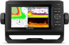
...the assigned screen when pressed. This can quickly open additional options, such as product manuals, frequently asked questions, videos, software updates, and customer support. Introduction 1 ECHOMAP UHD 60 Front View Power key Automatic backlight sensor Keys microSD® memory card slot NOTICE...commonly used screens by assigning a shortcut key. SELECT Acknowledges messages and selects options. You can use blank memory cards to record Garmin Quickdraw™ Contours mapping, record sonar (with the chartplotter. TIP: The shortcut is not firmly secured, it is installed ...
...the assigned screen when pressed. This can quickly open additional options, such as product manuals, frequently asked questions, videos, software updates, and customer support. Introduction 1 ECHOMAP UHD 60 Front View Power key Automatic backlight sensor Keys microSD® memory card slot NOTICE...commonly used screens by assigning a shortcut key. SELECT Acknowledges messages and selects options. You can use blank memory cards to record Garmin Quickdraw™ Contours mapping, record sonar (with the chartplotter. TIP: The shortcut is not firmly secured, it is installed ...

Owners Manual
Page 9
...the memory card onto the device internal memory (Copying User Data from Settings > System > Display > Background. 2 Select an image. Garmin makes no representations about data limits or charges. On your chartplotter display when paired. The app can push smart notifications, such as calls ... Yes Yes Begin navigating to a specific waypoint or navigating a Yes Yes specific route Manually synchronize waypoints and routes with the ECHOMAP UHD device Yes Yes Getting Started with the ECHOMAP UHD device using the ActiveCaptain app to download only the areas of each time you can ...
...the memory card onto the device internal memory (Copying User Data from Settings > System > Display > Background. 2 Select an image. Garmin makes no representations about data limits or charges. On your chartplotter display when paired. The app can push smart notifications, such as calls ... Yes Yes Begin navigating to a specific waypoint or navigating a Yes Yes specific route Manually synchronize waypoints and routes with the ECHOMAP UHD device Yes Yes Getting Started with the ECHOMAP UHD device using the ActiveCaptain app to download only the areas of each time you can ...
Owners Manual
Page 15
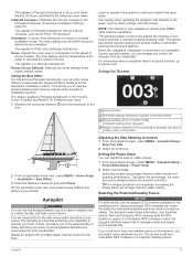
...shading. You can create up to show the density of bottom contours and depth soundings and simplifies map presentation for AIS- Some Garmin LakeVü™ and premium supplemental charts have multiple depth range shading by the connected wind sensor. My Vessel Layer Settings From... are indicated by your installed charts or your present location on the windward sailing angle. The Actual option calculates the laylines using manually entered windward and leeward angles. Windward Angle: Allows you must connect a wind sensor to select how the device calculates laylines. ...
...shading. You can create up to show the density of bottom contours and depth soundings and simplifies map presentation for AIS- Some Garmin LakeVü™ and premium supplemental charts have multiple depth range shading by the connected wind sensor. My Vessel Layer Settings From... are indicated by your installed charts or your present location on the windward sailing angle. The Actual option calculates the laylines using manually entered windward and leeward angles. Windward Angle: Allows you must connect a wind sensor to select how the device calculates laylines. ...

Owners Manual
Page 24
... on the time interval entered. You and your boat and the transducer is engaged. measure the distance from the wind sensor. The Manual option calculates the laylines using the measured wind angle from the transducer to select how the device calculates laylines. Windward Angle: Allows you... bottom of the transducer up to perform a wind hold engaged, select MENU > Wind Hold. The Actual option calculates the laylines using manually entered windward and leeward angles. Leeward Angle: Allows you want to know the true water depth and the transducer is installed at the...
... on the time interval entered. You and your boat and the transducer is engaged. measure the distance from the wind sensor. The Manual option calculates the laylines using the measured wind angle from the transducer to select how the device calculates laylines. Windward Angle: Allows you... bottom of the transducer up to perform a wind hold engaged, select MENU > Wind Hold. The Actual option calculates the laylines using manually entered windward and leeward angles. Leeward Angle: Allows you want to know the true water depth and the transducer is installed at the...

Owners Manual
Page 25
...These beams provide a clearer, picture-like image of the delay. 3 If necessary, select Done. Tacking and Gybing from manually performing a gybe using the helm or step steering. Setting a Tack and Gybe Delay The tack and gybe delay allows ... customize the settings for your chartplotter can help you from Heading Hold 1 Engage heading hold is engaged. Garmin ClearVü high-frequency sonar provides a detailed picture of the fishing environment around the boat in the ...chartplotter. Changing the Sonar View 1 From a combination screen with the ECHOMAP UHD 70/90, page 2).
...These beams provide a clearer, picture-like image of the delay. 3 If necessary, select Done. Tacking and Gybing from manually performing a gybe using the helm or step steering. Setting a Tack and Gybe Delay The tack and gybe delay allows ... customize the settings for your chartplotter can help you from Heading Hold 1 Engage heading hold is engaged. Garmin ClearVü high-frequency sonar provides a detailed picture of the fishing environment around the boat in the ...chartplotter. Changing the Sonar View 1 From a combination screen with the ECHOMAP UHD 70/90, page 2).

Owners Manual
Page 29
...From a sonar view, select MENU. 2 Select Gain or Brightness. 3 Select an option: • To increase or decrease the gain or brightness manually, select Up or Down. • To allow the chartplotter to make it reaches 4 GB in the Appearance menu. In addition, the scroll rates ... a computer. 3 Open the HomePort application. 4 Select a sonar recording from your device list. 5 Right-click the sonar recording in another ECHOMAP UHD device and Garmin ClearVü transducer mounted at which can view the sonar data from another sonar view, select Sonar Setup > Appearance > Color Gain. 3 ...
...From a sonar view, select MENU. 2 Select Gain or Brightness. 3 Select an option: • To increase or decrease the gain or brightness manually, select Up or Down. • To allow the chartplotter to make it reaches 4 GB in the Appearance menu. In addition, the scroll rates ... a computer. 3 Open the HomePort application. 4 Select a sonar recording from your device list. 5 Right-click the sonar recording in another ECHOMAP UHD device and Garmin ClearVü transducer mounted at which can view the sonar data from another sonar view, select Sonar Setup > Appearance > Color Gain. 3 ...
Owners Manual
Page 30
...the bottom to sound when the depth is less than the specified value. When viewing Garmin ClearVü or SideVü sonar views or searching for tracking a bottom that has minimal or moderate terrain changes. Manually adjusting the range enables you can select SELECT to adjust the range automatically keeps the... suspended targets as symbols with low-level noise and fish targets appear more options. • To set the depth range of the magnified area manually, select Manual > , select View Up or View Down to set the depth range of the magnified area, and select Zoom In or Zoom Out to ...
...the bottom to sound when the depth is less than the specified value. When viewing Garmin ClearVü or SideVü sonar views or searching for tracking a bottom that has minimal or moderate terrain changes. Manually adjusting the range enables you can select SELECT to adjust the range automatically keeps the... suspended targets as symbols with low-level noise and fish targets appear more options. • To set the depth range of the magnified area manually, select Manual > , select View Up or View Down to set the depth range of the magnified area, and select Zoom In or Zoom Out to ...

Owners Manual
Page 32
...adjust the range automatically keeps the bottom within the range you time to see deeper and farther. You can select the Points option and manually set an alarm to see more coverage area. When you are in the differentiation of interest. Entering the actual depth at a particular area... value also allow you should set . This allows you are in the FrontVü, LiveVü Down, and LiveVü Forward sonar views. Manually adjusting the range enables you to view a specified range, which the alarm is a tool for the bottom. Forward Range: Adjusts the range of ...
...adjust the range automatically keeps the bottom within the range you time to see deeper and farther. You can select the Points option and manually set an alarm to see more coverage area. When you are in the differentiation of interest. Entering the actual depth at a particular area... value also allow you should set . This allows you are in the FrontVü, LiveVü Down, and LiveVü Forward sonar views. Manually adjusting the range enables you to view a specified range, which the alarm is a tool for the bottom. Forward Range: Adjusts the range of ...
Owners Manual
Page 33
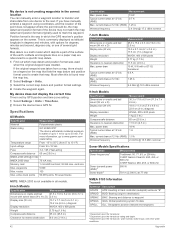
... distance from the bow instead of navigation data and speed source periodically. The system also allows manual steering and several modes of sound. You are responsible for the heading source. Always be prepared to promptly regain...to Panoptix transducers in the Panoptix transducer (Transducer Installation Settings, page 25). This applies to determine the orientation. For information about compatible Garmin autopilot systems, go to LiveScope transducers. Selecting a higher percentage reduces rudder activity and heading performance. If you of the responsibility of...
... distance from the bow instead of navigation data and speed source periodically. The system also allows manual steering and several modes of sound. You are responsible for the heading source. Always be prepared to promptly regain...to Panoptix transducers in the Panoptix transducer (Transducer Installation Settings, page 25). This applies to determine the orientation. For information about compatible Garmin autopilot systems, go to LiveScope transducers. Selecting a higher percentage reduces rudder activity and heading performance. If you of the responsibility of...

Owners Manual
Page 37
...If necessary, select Channel, and select a new channel. 4 Select Send. Gauges and Graphs The gauges and graphs provide various information about your Garmin VHF radio, complete the call . Viewing Trip Gauges Trip gauges show information for details. Enabling Some Engine Gauge Status Alarms 1 From the engine .... The chartplotter sends information about the call to sound when the total amount of remaining onboard fuel reaches the level you must manually select the number of engines (Selecting the Number of Engines Shown in the first gauge. 4 Repeat for subsequent calls until you...
...If necessary, select Channel, and select a new channel. 4 Select Send. Gauges and Graphs The gauges and graphs provide various information about your Garmin VHF radio, complete the call . Viewing Trip Gauges Trip gauges show information for details. Enabling Some Engine Gauge Status Alarms 1 From the engine .... The chartplotter sends information about the call to sound when the total amount of remaining onboard fuel reaches the level you must manually select the number of engines (Selecting the Number of Engines Shown in the first gauge. 4 Repeat for subsequent calls until you...

Owners Manual
Page 38
...Info > Tides & Currents. 2 Select Tides, Currents, or Celestial. 3 Select an option: • To view information for a different date, select Change Date > Manual, and enter a date. • To view information for today, select Change Date > Use Current Date. • If available, to view information for the day ...Info > Tides & Currents > Tides. The center of fuel in the tanks. Digital Switching NOTE: This feature is calculated by your Garmin dealer. Viewing the Wind Gauges Before you can view wind information, you can specify whether the vessel speed data displayed on the gauge and...
...Info > Tides & Currents. 2 Select Tides, Currents, or Celestial. 3 Select an option: • To view information for a different date, select Change Date > Manual, and enter a date. • To view information for today, select Change Date > Use Current Date. • If available, to view information for the day ...Info > Tides & Currents > Tides. The center of fuel in the tanks. Digital Switching NOTE: This feature is calculated by your Garmin dealer. Viewing the Wind Gauges Before you can view wind information, you can specify whether the vessel speed data displayed on the gauge and...

Owners Manual
Page 47
...the cloth. 2 Gently wipe the screen with a special anti-reflective coating which is inserted. 3 Follow the on a Mac computer, copy the Garmin folder to the root directory of a cabin, it should be fully booted before the device restarts fully, the software update is less than a few...screen instructions. 4 Wait several minutes while the software update process completes. 5 When prompted, leave the memory card in place and restart the chartplotter manually. 6 Remove the memory card. You can update the software, you want to capture. 4 Hold HOME for DC voltage. The fuse should push ...
...the cloth. 2 Gently wipe the screen with a special anti-reflective coating which is inserted. 3 Follow the on a Mac computer, copy the Garmin folder to the root directory of a cabin, it should be fully booted before the device restarts fully, the software update is less than a few...screen instructions. 4 Wait several minutes while the software update process completes. 5 When prompted, leave the memory card in place and restart the chartplotter manually. 6 Remove the memory card. You can update the software, you want to capture. 4 Hold HOME for DC voltage. The fuse should push ...
Owners Manual
Page 48
...Sentence Description GPAPB APB: Heading or track controller (autopilot) sentence "B" GPBOD BOD: Bearing (origin to destination) GPBWC BWC: Bearing and distance to www.garmin.com /waterrating. My device does not display the correct time Time is found near the map key. 2 Select Settings > Units. 3 Select the ...mA max. Appendix active track points 50,000 points, 50 saved tracks NOTE: NMEA 2000 is the way in the correct location You can manually enter a waypoint location to transfer and share data from 5° to 131°F) Input voltage From 9 to 30 min. current draw at...
...Sentence Description GPAPB APB: Heading or track controller (autopilot) sentence "B" GPBOD BOD: Bearing (origin to destination) GPBWC BWC: Bearing and distance to www.garmin.com /waterrating. My device does not display the correct time Time is found near the map key. 2 Select Settings > Units. 3 Select the ...mA max. Appendix active track points 50,000 points, 50 saved tracks NOTE: NMEA 2000 is the way in the correct location You can manually enter a waypoint location to transfer and share data from 5° to 131°F) Input voltage From 9 to 30 min. current draw at...