
Owners Manual
Page 3
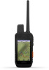
... Device 1 Dog Collar Device 1 Installing the Battery Pack 1 Charging the Handheld Device 2 Charging the Dog Collar Device 2 Turning On the Device 2 Turning Off the Device 2 Selecting a Language 2 Using the Touchscreen 2 Using the Status Page 2 Acquiring Satellite Signals 2 Iridium® Satellite Network 2 Activating the Device 3 Dog Collar Device Setup 3 Methods to Add a Dog Collar Device to a Handheld Device ...... 3 Adding a Dog to the Alpha Handheld Using Wireless Pairing 3 Sharing a Dog Wirelessly 3 Adding a Dog Using the Track and Control Codes 3 VHF Radio Information...
... Device 1 Dog Collar Device 1 Installing the Battery Pack 1 Charging the Handheld Device 2 Charging the Dog Collar Device 2 Turning On the Device 2 Turning Off the Device 2 Selecting a Language 2 Using the Touchscreen 2 Using the Status Page 2 Acquiring Satellite Signals 2 Iridium® Satellite Network 2 Activating the Device 3 Dog Collar Device Setup 3 Methods to Add a Dog Collar Device to a Handheld Device ...... 3 Adding a Dog to the Alpha Handheld Using Wireless Pairing 3 Sharing a Dog Wirelessly 3 Adding a Dog Using the Track and Control Codes 3 VHF Radio Information...
Owners Manual
Page 4
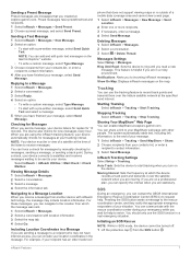
... an Area 13 Setting an Alarm 13 Using the Competition Timer 13 Satellite Page 13 Changing the Satellite View 13 Turning Off GPS 13 Simulating a Location 13 Downloading BirdsEye Imagery 13 Customizing Your Device 14 Customizing the Main Menu 14 Customizing the Data Fields 14 System Settings 14 Display Settings 14 Accessibility Settings 14 Setting the Device Tones 14 Setting Dog Alerts 14 Map Settings 14 Tracked Devices Map Settings 14 Advanced Map Settings 14 Tracks Settings 14 Routing Settings 14 Sensors Settings 15 Changing the Units of Contents...
... an Area 13 Setting an Alarm 13 Using the Competition Timer 13 Satellite Page 13 Changing the Satellite View 13 Turning Off GPS 13 Simulating a Location 13 Downloading BirdsEye Imagery 13 Customizing Your Device 14 Customizing the Main Menu 14 Customizing the Data Fields 14 System Settings 14 Display Settings 14 Accessibility Settings 14 Setting the Device Tones 14 Setting Dog Alerts 14 Map Settings 14 Tracked Devices Map Settings 14 Advanced Map Settings 14 Tracks Settings 14 Routing Settings 14 Sensors Settings 15 Changing the Units of Contents...

Owners Manual
Page 6
... (Alpha Handheld Device Specifications, page 15). Charging the Handheld Device NOTICE To prevent corrosion, thoroughly dry the USB port, the weather cap, and the surrounding area before you are enabled, select and to send the information until the LCD screen turns off . The LCD display on the charging clip cable. 3 Plug the power cable into an appropriate power source. You should fully charge the battery before connecting the charging clip. Screen brightness: Adjusts...
... (Alpha Handheld Device Specifications, page 15). Charging the Handheld Device NOTICE To prevent corrosion, thoroughly dry the USB port, the weather cap, and the surrounding area before you are enabled, select and to send the information until the LCD screen turns off . The LCD display on the charging clip cable. 3 Plug the power cable into an appropriate power source. You should fully charge the battery before connecting the charging clip. Screen brightness: Adjusts...
Owners Manual
Page 7
... track your Alpha handheld device within range 3 m (10 ft.) to track the dog. The two handheld devices must be receiving the device information (Adding a Dog to add a dog collar device that you do not own and that is helpful when you must activate it (inReach Features, page 6). 1 Create an account, and select a satellite subscription at one handheld device by using MURS/VHF, entering the track and control codes...
... track your Alpha handheld device within range 3 m (10 ft.) to track the dog. The two handheld devices must be receiving the device information (Adding a Dog to add a dog collar device that you do not own and that is helpful when you must activate it (inReach Features, page 6). 1 Create an account, and select a satellite subscription at one handheld device by using MURS/VHF, entering the track and control codes...
Owners Manual
Page 10
... satellite network. You must customize your data from being seen on the map. Select Setup > System > Broadcast Dog Data > Off. You can also add a dog training command to operate properly. Messages Your Alpha 200i device sends and receives text messages using the device's hard keys. 1 From any screen, press the training up and down keys until the command page you want to adjust appears. 2 Press the training enter...
... satellite network. You must customize your data from being seen on the map. Select Setup > System > Broadcast Dog Data > Off. You can also add a dog training command to operate properly. Messages Your Alpha 200i device sends and receives text messages using the device's hard keys. 1 From any screen, press the training up and down keys until the command page you want to adjust appears. 2 Press the training enter...
Owners Manual
Page 11
... mode, the device cannot be sent to be turned off. 1 Lift the protective cap from the SOS button . For these messages, you can specify the interval when you are stationary. Deleting Messages 1 Select inReach > Messages. 2 Select a conversation. 3 Select > Delete Thread. Starting Tracking Select inReach > Tracking > Start Tracking. You can include your device connects to satellites and receives messages waiting to your tracking interval. Moving Interval: Sets the frequency at the time...
... mode, the device cannot be sent to be turned off. 1 Lift the protective cap from the SOS button . For these messages, you can specify the interval when you are stationary. Deleting Messages 1 Select inReach > Messages. 2 Select a conversation. 3 Select > Delete Thread. Starting Tracking Select inReach > Tracking > Start Tracking. You can include your device connects to satellites and receives messages waiting to your tracking interval. Moving Interval: Sets the frequency at the time...

Owners Manual
Page 12
... receive the weather forecast data. NOTE: You cannot delete the My Location forecast. 3 Select > Delete. Wait while the device sends a test message. BirdsEye imagery: Allows you to download BirdsEye Satellite Imagery directly to your satellite subscription is active. To conserve battery power after it on the map. When you receive a confirmation message from the emergency response service. inReach Weather: You can receive weather information. Marine forecasts are available for your current location, a waypoint, GPS coordinates, or a location...
... receive the weather forecast data. NOTE: You cannot delete the My Location forecast. 3 Select > Delete. Wait while the device sends a test message. BirdsEye imagery: Allows you to download BirdsEye Satellite Imagery directly to your satellite subscription is active. To conserve battery power after it on the map. When you receive a confirmation message from the emergency response service. inReach Weather: You can receive weather information. Marine forecasts are available for your current location, a waypoint, GPS coordinates, or a location...
Owners Manual
Page 13
... your Alpha device. Changes made to download maps for the hunt (Adding a Contact Using Wireless Pairing, page 9). Turning On and Off the Transmitter Before you can use cloud storage for your waypoints, routes, and tracks. NOTE: In cold temperatures, if you transmit when the battery is not in the Garmin Explore app to record track points and transmit them an inReach message from the field. Entering the device...
... your Alpha device. Changes made to download maps for the hunt (Adding a Contact Using Wireless Pairing, page 9). Turning On and Off the Transmitter Before you can use cloud storage for your waypoints, routes, and tracks. NOTE: In cold temperatures, if you transmit when the battery is not in the Garmin Explore app to record track points and transmit them an inReach message from the field. Entering the device...

Owners Manual
Page 15
... map, select Review. • To change the order of measure. 6 Enter the distance, and select . 7 Select Save. Projecting a Waypoint You can create a new location by transferring the file to the GPX folder (Connecting the Handheld Device to a Computer, page 17). Creating a Route 1 Select Route Planner > Create Route > Select First Point. 2 Select a category. 3 Select the first point on the route, select Insert. Navigating a Saved Route 1 Select Route Planner. 2 Select a route. 3 Select View Map...
... map, select Review. • To change the order of measure. 6 Enter the distance, and select . 7 Select Save. Projecting a Waypoint You can create a new location by transferring the file to the GPX folder (Connecting the Handheld Device to a Computer, page 17). Creating a Route 1 Select Route Planner > Create Route > Select First Point. 2 Select a category. 3 Select the first point on the route, select Insert. Navigating a Saved Route 1 Select Route Planner. 2 Select a route. 3 Select View Map...

Owners Manual
Page 16
...; To control the current track recording, select the current track tab. • To view data fields for the track, select the information tab. • To view the current track on and has acquired satellite signals. Finding a Waypoint by flags. 4 Select the information bar along your location on the map. Navigation You can point the device at an object. 3 Select Lock Direction > Set Course. Map represents your recorded path, including time, location, and elevation...
...; To control the current track recording, select the current track tab. • To view data fields for the track, select the information tab. • To view the current track on and has acquired satellite signals. Finding a Waypoint by flags. 4 Select the information bar along your location on the map. Navigation You can point the device at an object. 3 Select Lock Direction > Set Course. Map represents your recorded path, including time, location, and elevation...
Owners Manual
Page 17
.... 2 Walk around the perimeter of the screen. Simulating a Location 1 Select Satellite > > Demo Mode. 2 Select > Set Location On Map. 3 Select a location. 4 Select Use. An estimated file size appears for a specific location or area, select Location, and select a category. You should verify your current speed, average speed, maximum speed, trip odometer, and other helpful statistics. Changing the Plot Type You can change the view of the satellites to be oriented with your dogs...
.... 2 Walk around the perimeter of the screen. Simulating a Location 1 Select Satellite > > Demo Mode. 2 Select > Set Location On Map. 3 Select a location. 4 Select Use. An estimated file size appears for a specific location or area, select Location, and select a category. You should verify your current speed, average speed, maximum speed, trip odometer, and other helpful statistics. Changing the Plot Type You can change the view of the satellites to be oriented with your dogs...
Owners Manual
Page 18
... Settings Select Setup > Display. Backlight Timeout: Adjusts the length of Wide Area Augmentation System/ European Geostationary Navigation Overlay Service (WAAS/ EGNOS) data. Map Settings Select Setup > Map. Show Data Fields: Displays configurable data fields on the map (if available) or turns off the screen when the backlight times out (Turning On the Handheld Battery Save Mode, page 16). Dog Tracks on the device screen. Select Setup > Routing. 14 Customizing Your Device Appearance: Sets the displayed accent colors for longer track recordings. Accessibility: Adds or changes...
... Settings Select Setup > Display. Backlight Timeout: Adjusts the length of Wide Area Augmentation System/ European Geostationary Navigation Overlay Service (WAAS/ EGNOS) data. Map Settings Select Setup > Map. Show Data Fields: Displays configurable data fields on the map (if available) or turns off the screen when the backlight times out (Turning On the Handheld Battery Save Mode, page 16). Dog Tracks on the device screen. Select Setup > Routing. 14 Customizing Your Device Appearance: Sets the displayed accent colors for longer track recordings. Accessibility: Adds or changes...
Owners Manual
Page 19
... coordinate system is structured. Updating the software does not erase any of roads, terrain, and transportation methods to remotely send messages from a compatible Xero® device. Never use it to avoid while navigating. Avoid chemical cleaners, solvents, and insect repellents that specifies a different position format. Cleaning the Device 1 Wipe the device using . After cleaning, allow the device to 20 hr. Specifications Alpha Handheld Device Specifications Battery type Battery life Operating temperature range Charging...
... coordinate system is structured. Updating the software does not erase any of roads, terrain, and transportation methods to remotely send messages from a compatible Xero® device. Never use it to avoid while navigating. Avoid chemical cleaners, solvents, and insect repellents that specifies a different position format. Cleaning the Device 1 Wipe the device using . After cleaning, allow the device to 20 hr. Specifications Alpha Handheld Device Specifications Battery type Battery life Operating temperature range Charging...
Owners Manual
Page 20
... Collar Device Specifications Battery type Internal rechargeable lithium-ion battery Battery life Operating temperature range Charging temperature range From 20 to remove batteries. Do not use battery save mode to maximize the battery life. CAUTION Contact your device to maximize the battery life. 1 Select Setup > Display > Backlight Timeout. 2 Select an option. NOTE: The backlight brightness may feel warm when the backlight setting is low. 1 Select . 2 Use the slider bar to properly recycle the batteries. Turning On...
... Collar Device Specifications Battery type Internal rechargeable lithium-ion battery Battery life Operating temperature range Charging temperature range From 20 to remove batteries. Do not use battery save mode to maximize the battery life. CAUTION Contact your device to maximize the battery life. 1 Select Setup > Display > Backlight Timeout. 2 Select an option. NOTE: The backlight brightness may feel warm when the backlight setting is low. 1 Select . 2 Use the slider bar to properly recycle the batteries. Turning On...
Owners Manual
Page 21
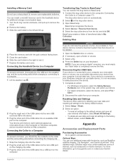
... and save all user-entered information, select Reset All Settings. • To delete all user data and reset all settings to avoid data loss. You can install a microSD memory card in My Computer on your Garmin dealer. Transferring Dog Tracks to BaseCamp™ You can use a sharp object to safely disconnect the device. 1 Complete an action: • For Windows computers, select the Safely Remove Hardware icon in My Collection. Appendix Accessories and Replacement Parts...
... and save all user-entered information, select Reset All Settings. • To delete all user data and reset all settings to avoid data loss. You can install a microSD memory card in My Computer on your Garmin dealer. Transferring Dog Tracks to BaseCamp™ You can use a sharp object to safely disconnect the device. 1 Complete an action: • For Windows computers, select the Safely Remove Hardware icon in My Collection. Appendix Accessories and Replacement Parts...

Owners Manual
Page 22
...+ accessory each time it is an ANT+ wireless temperature sensor. T 5 Battery Replacement Instructions T 5 Components Back plate Power key Battery connector Battery cover Battery Power connector Removing the Old Battery Before you replace the battery, you install the new battery, charge the collar completely. You must pair the tempe with Your Garmin Device • Verify that secure the battery cover. 5 Remove the battery cover and the battery. You may need a small flat screwdriver. 1 Install the new battery using a non-sharp...
...+ accessory each time it is an ANT+ wireless temperature sensor. T 5 Battery Replacement Instructions T 5 Components Back plate Power key Battery connector Battery cover Battery Power connector Removing the Old Battery Before you replace the battery, you install the new battery, charge the collar completely. You must pair the tempe with Your Garmin Device • Verify that secure the battery cover. 5 Remove the battery cover and the battery. You may need a small flat screwdriver. 1 Install the new battery using a non-sharp...

Owners Manual
Page 24
... remaining battery power. You must be navigating for this data to your destination and your elapsed time is a blank data field. Minimum: The lowest elevation reached since the last reset. Lap Speed: The average speed for the current activity. Location (lat/lon): The current position in all the completed laps. Speed: The current rate of the GPS satellite signal. Your body temperature affects the temperature sensor. Elevation - GPS Signal Strength...
... remaining battery power. You must be navigating for this data to your destination and your elapsed time is a blank data field. Minimum: The lowest elevation reached since the last reset. Lap Speed: The average speed for the current activity. Location (lat/lon): The current position in all the completed laps. Speed: The current rate of the GPS satellite signal. Your body temperature affects the temperature sensor. Elevation - GPS Signal Strength...
Owners Manual
Page 26
... -screen buttons 2 P pairing ANT+ sensors 18 smartphone 9 position format 15 power cables, changing the fuse 19 power key 1, 2 product registration 15 proximity alarms 13 R radio communication 4 radio frequencies 4 registering the device 15 replacement parts 17-19 rescue mode 10 resetting the device 17 routes 11 creating 11 deleting 12 editing 11 navigating 11 settings 14 S satellite signals 2, 13 acquiring 2 settings 6, 7, 14, 15 device 14, 15 Sight 'N Go 12 sleep mode 5 smartphone 9 applications 8 pairing 9 software updates 15 updating 15 SOS 6, 7 canceling 8 sending 7, 8 specifications...
... -screen buttons 2 P pairing ANT+ sensors 18 smartphone 9 position format 15 power cables, changing the fuse 19 power key 1, 2 product registration 15 proximity alarms 13 R radio communication 4 radio frequencies 4 registering the device 15 replacement parts 17-19 rescue mode 10 resetting the device 17 routes 11 creating 11 deleting 12 editing 11 navigating 11 settings 14 S satellite signals 2, 13 acquiring 2 settings 6, 7, 14, 15 device 14, 15 Sight 'N Go 12 sleep mode 5 smartphone 9 applications 8 pairing 9 software updates 15 updating 15 SOS 6, 7 canceling 8 sending 7, 8 specifications...

Important Safety and Product Information
Page 2
... the display. Changing the antenna can be released that may cause undesired operation of any user-serviceable parts. Software License Agreement BY USING THE DEVICE, YOU AGREE TO BE BOUND BY THE TERMS AND CONDITIONS OF THE FOLLOWING SOFTWARE LICENSE AGREEMENT. Only access the information displayed on the country of use of the activity before navigating along unfamiliar paths and trails. If these guidelines to radio or...
... the display. Changing the antenna can be released that may cause undesired operation of any user-serviceable parts. Software License Agreement BY USING THE DEVICE, YOU AGREE TO BE BOUND BY THE TERMS AND CONDITIONS OF THE FOLLOWING SOFTWARE LICENSE AGREEMENT. Only access the information displayed on the country of use of the activity before navigating along unfamiliar paths and trails. If these guidelines to radio or...
Important Safety and Product Information
Page 3
... purchase or follow the instructions on support.garmin.com. In some cases, Garmin and its sole discretion and subject to applicable laws, repair or replace your product with this Limited Warranty, then Garmin will not replace missing components from any Global Navigation Satellite System (GNSS) such as the Global Positioning Service (GPS). Use of such devices may be available due to a Garmin Authorized service facility in another...
... purchase or follow the instructions on support.garmin.com. In some cases, Garmin and its sole discretion and subject to applicable laws, repair or replace your product with this Limited Warranty, then Garmin will not replace missing components from any Global Navigation Satellite System (GNSS) such as the Global Positioning Service (GPS). Use of such devices may be available due to a Garmin Authorized service facility in another...


