Owner's Manual - Audio (english)
Page 7
...potential dangers resulting from that the volume level of the navigation system is set to a level which may cause harmful interference to your local Alpine authorized navigation dealer or Alpine at the time of the navigation system which you consider unsafe. • Glance at ...destination. type of road surface, slope or grade, weight or height restrictions, etc.), traffic congestion, weather conditions, or any interference received, including interference that all locations of the FCC Rules. These limits are contained in these precautions and the following two conditions: (1)...
...potential dangers resulting from that the volume level of the navigation system is set to a level which may cause harmful interference to your local Alpine authorized navigation dealer or Alpine at the time of the navigation system which you consider unsafe. • Glance at ...destination. type of road surface, slope or grade, weight or height restrictions, etc.), traffic congestion, weather conditions, or any interference received, including interference that all locations of the FCC Rules. These limits are contained in these precautions and the following two conditions: (1)...
Owner's Manual - Audio (english)
Page 16
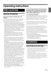
...Touch [Sound Menu] icon on the screen for selecting the screen size. Screen Off Function This mode is useful if you can display the Navigation and Audio/Visual screens simultaneously. Sound Menu Screen [Sound Menu] icon About Dual Screen If you want to the Sound Menu screen. For... details, refer to the reverse (R) position while the rear camera is connected, the rear camera image is displayed. • When a call is received while a BLUETOOTH device is connected, the incoming call screen is displayed. To cancel Screen OFF mode, touch the screen or press any button. •...
...Touch [Sound Menu] icon on the screen for selecting the screen size. Screen Off Function This mode is useful if you can display the Navigation and Audio/Visual screens simultaneously. Sound Menu Screen [Sound Menu] icon About Dual Screen If you want to the Sound Menu screen. For... details, refer to the reverse (R) position while the rear camera is connected, the rear camera image is displayed. • When a call is received while a BLUETOOTH device is connected, the incoming call screen is displayed. To cancel Screen OFF mode, touch the screen or press any button. •...

Owner's Manual - Navigation (english)
Page 6
...we recommend that you start your journey. It is safe to do so. If you . The software does not transmit your destination with a connected GPS receiver. others cannot track you deviate from the recommended route, your software before your departure and stop if you find your way to your GPS position... you look at the display only when it is important that you operate your software changes the instructions accordingly. 6 1 Warnings and Safety information The navigation system helps you need to change the route. You must obey the traffic signs and follow the road geometry.
...we recommend that you start your journey. It is safe to do so. If you . The software does not transmit your destination with a connected GPS receiver. others cannot track you deviate from the recommended route, your software before your departure and stop if you find your way to your GPS position... you look at the display only when it is important that you operate your software changes the instructions accordingly. 6 1 Warnings and Safety information The navigation system helps you need to change the route. You must obey the traffic signs and follow the road geometry.
Owner's Manual - Navigation (english)
Page 15
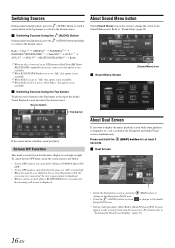
... small arrows at the top of the map. All signposts look similar when cruising (when there is available. Where additional information is received. If you want to hide the currently displayed signposts, tap any of the road the lane leads to the real ones you need...to take are displayed with updated distance information. • Tap the Next street field to open the Itinerary. 2.2.3.3 Lane information and Signposts When navigating on multilane roads, it is important to take . The lanes you can be taken is displayed in Visual Guidance settings. 2.2.3.4 Junction view If...
... small arrows at the top of the map. All signposts look similar when cruising (when there is available. Where additional information is received. If you want to hide the currently displayed signposts, tap any of the road the lane leads to the real ones you need...to take are displayed with updated distance information. • Tap the Next street field to open the Itinerary. 2.2.3.3 Lane information and Signposts When navigating on multilane roads, it is important to take . The lanes you can be taken is displayed in Visual Guidance settings. 2.2.3.4 Junction view If...
Owner's Manual - Navigation (english)
Page 19
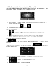
... about the last known position if GPS reception is displayed below the Vehimarker (the current position on this screen: Tap Information. screen. • In the Navigation menu, tap Information on the map), tap it to open a new The following ways: • If the current street is not available) and a button to...
... about the last known position if GPS reception is displayed below the Vehimarker (the current position on this screen: Tap Information. screen. • In the Navigation menu, tap Information on the map), tap it to open a new The following ways: • If the current street is not available) and a button to...
Owner's Manual - Navigation (english)
Page 21
...The software offers you several ways of choosing your destination: • Enter a full address or a part of an address, for off the GPS receiver and set up your route in different ways: • If you know at the current position). Then select a second destination and add it ... house number • the center of a city/town • an intersection • the midpoint of a street 21 3 On-road navigation When first started, Alpine unit calculates routes using the road network of the high quality vector maps provided with multiple destinations. Select the first destination. You can also...
...The software offers you several ways of choosing your destination: • Enter a full address or a part of an address, for off the GPS receiver and set up your route in different ways: • If you know at the current position). Then select a second destination and add it ... house number • the center of a city/town • an intersection • the midpoint of a street 21 3 On-road navigation When first started, Alpine unit calculates routes using the road network of the high quality vector maps provided with multiple destinations. Select the first destination. You can also...
Owner's Manual - Navigation (english)
Page 54
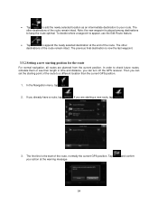
... or see their length in time and distance, you already have a route, tap . and confirm 54 If you can turn off the GPS receiver. The other destinations of the route remain intact. If you can set the starting a new route, tap . 3. The previous final destination is... now the last waypoint. 3.3.2 Setting a new starting position for the route For normal navigation, all routes are starting point of the route. Then you are planned from the current position. In the Navigation menu, tap . 2. The other destinations of the route, normally the current GPS position....
... or see their length in time and distance, you already have a route, tap . and confirm 54 If you can turn off the GPS receiver. The other destinations of the route remain intact. If you can set the starting a new route, tap . 3. The previous final destination is... now the last waypoint. 3.3.2 Setting a new starting position for the route For normal navigation, all routes are starting point of the route. Then you are planned from the current position. In the Navigation menu, tap . 2. The other destinations of the route, normally the current GPS position....
Owner's Manual - Navigation (english)
Page 65
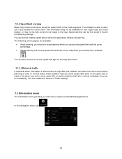
... fall on the map when you exceed it (for example: ). You can set the relative speed above which the application initiates the warning. In the Navigation menu, tap . 65 Speed warning can be misleading. This information may not be available for your region (ask your local dealer), or may contain information... If statistical traffic information is able to warn you if you exceed the current limit. The following warning types are available: • Audio warning: you receive a verbal warning when you exceed the speed limit with various options and additional applications.
... fall on the map when you exceed it (for example: ). You can set the relative speed above which the application initiates the warning. In the Navigation menu, tap . 65 Speed warning can be misleading. This information may not be available for your region (ask your local dealer), or may contain information... If statistical traffic information is able to warn you if you exceed the current limit. The following warning types are available: • Audio warning: you receive a verbal warning when you exceed the speed limit with various options and additional applications.
Owner's Manual - Navigation (english)
Page 78
...on how accurately the GPS device can block the signals, your GPS device might not receive four signals. You can use digital maps interactively: you reach your position. In GPS-supported navigation, digital maps facilitate route planning. Because the satellites are not simply the computerized versions ... not give a three-dimensional position, including elevation. This is one given by colors. 6 Glossary 2D/3D GPS reception The GPS receiver uses satellite signals to calculate its top always faces North. City Center The city/town center is not the geometric center of the...
...on how accurately the GPS device can block the signals, your GPS device might not receive four signals. You can use digital maps interactively: you reach your position. In GPS-supported navigation, digital maps facilitate route planning. Because the satellites are not simply the computerized versions ... not give a three-dimensional position, including elevation. This is one given by colors. 6 Glossary 2D/3D GPS reception The GPS receiver uses satellite signals to calculate its top always faces North. City Center The city/town center is not the geometric center of the...


