Magellan RoadMate 1200 Support Question
Magellan RoadMate 1200 Support Question
Find answers below for this question about Magellan RoadMate 1200 - Automotive GPS Receiver.Need a Magellan RoadMate 1200 manual? We have 12 online manuals for this item!
Question posted by jeffreykoehler on March 2nd, 2012
Will The Magellan 1200 Work Without Sd Card?
The person who posted this question about this Magellan product did not include a detailed explanation. Please use the "Request More Information" button to the right if more details would help you to answer this question.
Current Answers
Related Magellan RoadMate 1200 Manual Pages
Triton User Manual Addendum - English, French, Spanish - Page 1

The Triton receiver can now access the Main Menu on any navigational screen press ENTER. In this software update ...track, press ENTER from any of the Navigational screens by your Triton.
Triton User Manual Addendum
This addendum applies to Triton GPS receivers that have a software version that you want to or higher then the ones listed. The most noticeable change in the ...
Triton User Manual Addendum - English, French, Spanish - Page 2

... parameters. Select View > Settings > Navigation. When setting a custom position, the GPS portion of the receiver is disabled and the screen is activated it to navigate next too.
When you have... to C to D to the next destination (D). To turn the feature off and resume computing GPS position information, go to E. To set through the navigation screens to the next waypoint in a ...
Manual - English - Page 2
...
Use only Magellan cables and antennas; i
Taking your selected destination.
When using the Magellan Triton, these safety rules must be affected by the periodic adjustments to GPS satellites made by... this guide may severely degrade performance or damage the receiver, and will void the warranty. IMPORTANT SAFETY WARNINGS
The Magellan Triton is subject to change any settings on one ...
Manual - English - Page 3
...relocate the receiving antenna. • Increase the separation between the equipment and receiver. • Connect the equipment into an outlet on a circuit different from the user. The Magellan Triton must...this device must be co-located or operating in conjunction with any interference received, including interference that changes and modifications made to the equipment without the approval...
Manual - English - Page 9

... for marine cartography, topographic maps, as well as they become available.
Features of the Magellan Triton
Ease-of possible software updates and new features as feature-packed National Geographic maps from an SD card that you for first time GPS receiver users while still keeping all the features needed to upload detailed maps and store...
Manual - English - Page 10
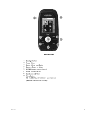
A
B
C E
F G
D I
H
Magellan Triton
A Backlight Button B Power Button C Zoom - (Zoom out) Button D Zoom + (Zoom in) Button E ENTER Button / Cursor Control F PAGE / GO TO Button G Esc (Escape) Button H Menu Button I SD Card Slot (under protective rubber cover)
[Magellan Triton 400 & 500 only]
Overview
2
Manual - English - Page 11

...GPS only English, French, German, Dutch, Danish, Swedish, Spanish, Italian, Portuguese, Finnish, Norwegian Latitude/Longitude, UTM, OSGB, Irish, Swish, Swedish, Finnish, German, French, USNG, MGRS, Indian, Nederlands, User Grid, and others. w/ battery 2.2" (5.59cm) diagonal, QVGA (240 x 320) resolution, LED backlit Internal memory or Secure Digital (SD) Card...
PERFORMANCE
Receiver Acquisition Time...
Manual - English - Page 14

...waypoint and use it as the destination waypoint for information on an optional SD card (400 & 500) or into the Magellan Triton as the Go To Menu but these menu options brings up the menu... option will turn off automatically.
7. The Create Menu has the same options as part of the Magellan Triton is a saved track.) The Geocache option allows you want the Triton to follow from the list...
Manual - English - Page 16
...and the Satellite Status screen have data fields that can be purchased and downloaded from the Magellan Store and installed using the optional National Geographic software. Select Customize Fields. 3. Select ...for the Map Screen
1. Magellan Triton 300 installs the National Geographic maps into their internal memory, while Magellan Triton 400 and 500 stores the maps on an SD card. Select OK. You ...
Manual - English - Page 17
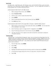
...the receiver) to 15s.
Select Settings. 4. Select a low backlight level during nighttime use .
1. Use the left /right cursor
control to move the slider to cycle through the backlight intensities.
(Alternate method)
1.
Turn off backlight during nighttime use.
1. Select View. 3. Select Volume & Brightness. 5. Disable the electronic compass if GPS fix is available. (Magellan...
Manual - English - Page 24
The numbers indicate the GPS satellite ID while "W" indicates WAAS (Wide Area Augmentation System) satellites. ... icons show signal strengths of the screen as colored bars.
Navigation Screens
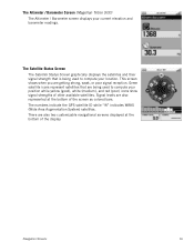
16 The Altimeter / Barometer Screen (Magellan Triton 500)
The Altimeter / Barometer screen displays your current elevation and barometer readings.
There are getting strong, weak, or...
Manual - English - Page 26
... the user is travelling off the trail or route. If the user is moving away from trees, tunnels, tall buildings, canyons, broadcast satellites, and other GPS receivers too close in distance) the progress the user has made . If no Go To or Route is set , this will appear blank or dashes.
Things...
Manual - English - Page 27

...Current Route Indicator (Line displaying line of waypoints saved in the Magellan Triton and it has a special contextual menu that can assign...the screen. Map Screen Overview
Battery Level
Time of Day
GPS Signal Strength
North Indicator
Data Fields
Map Scale
Pan Mode
...travel .)
Trail (Track that has been saved in the receiver.)
Start Flag (Indicates the starting point of the active route...
Manual - English - Page 37
...the day portion of the calendar is highlighted you will work as well.
These tabs are used to select them from the GPS satellite. The Waypoint Information screen shown here has three...date for local information and waypoint data. NEW SHORTCUT: Recently added is automatically received from ; Date Entry
The Magellan Triton uses a standard calendar display to step between the pages, the LEFT ...
Manual - English - Page 39
...
On, Off Various Various Various
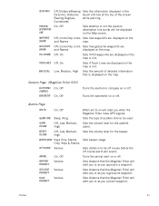
Sets beeper usage. Sets distance that the Magellan Triton will alert you a place waypoint. Alarms Page
GPS FIX
On, Off
ALARM TONE
ALARM VOLUME
BEEPER VOLUME
Beep, Ring
Off... Low, Medium, High
When set to on will alert you to as you when the Magellan Triton loses GPS signals. Sets the volume level for the audible alarm. Off, On
Sets if POI waypoints...
Manual - English - Page 40
... you enter a unique name for the waypoint.
This screen also provides information on the SD card and not in the Triton's internal memory.
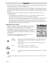
An understanding of three pages that have been... practice, and will avoid confusion later, if you are and a waypoint of your Magellan Triton. The Magellan Triton uses waypoints much the same as user-created and place waypoints in the chapter on...
Manual - English - Page 46
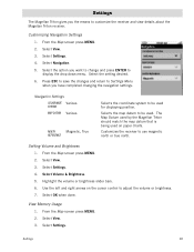
...brightness slider bars. 6. From the Map screen press MENU. 2. Select View. 3. Settings
The Magellan Triton gives you the means to adjust the volume or brightness. 7. From the Map screen press... to be used on the cursor control to customize the receiver and view details about the Magellan Triton receiver. Select Settings. Customizing Navigation Settings
1. Navigation Settings
COORDINATE ...
Manual - English - Page 50

...directly into the VantagePoint software and then transfer the information into the Magellan Triton. Geocache information includes Difficulty (1 through 5 with 5 being the most difficult), Terrain (1 though 5 with GPS users. Some geocaches will hide caches ("treasures") and record the ...Geocache Waypoint
You may want to add media (image) from the SD card installed in finding the cache.
Manual - English - Page 61
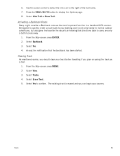
... press away.
1. 6. Select Erase Track. 5. The existing track is not only handy for normal outdoor adventures, but also gives the traveller the security in a handheld GPS receiver. Press the PAGE / GO TO button to your starting point is erased and you can begin your track before travelling if you should clear your...
Manual - English - Page 65
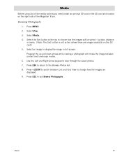
...step through the saved photos. 7. Select View. 3. Select Media. 4.
Media
Before using any of the Magellan Triton. Select the Sort button at the top to exit Browse Photographs. by date, distance
or name....rotate the image between List and Grid View to display the image in the SD card slot located on the SD card.) 5. Select an image to change how the images are images available on the...
Similar Questions

I Found A Magellan Roadmate 1200. Is It Possible To View Maps W/o An Sd Card?
I found a Magellan RoadMate 1200. Is it possible to view maps w/o an SD card?
I found a Magellan RoadMate 1200. Is it possible to view maps w/o an SD card?
(Posted by horseflybite9 1 year ago)

How To Update Magellan Roadmate 1200 Thru Sd Card
(Posted by deljeff 9 years ago)

How To Update Maps On Magellan Roadmate 1200 With Sd Card
(Posted by kpglyam 9 years ago)

How To Free Update Sd Card Magellan Roadmate 1200
(Posted by chzm 10 years ago)
Sd Card
How do I get the original data for the SD card for my Magellan 1212
How do I get the original data for the SD card for my Magellan 1212
(Posted by bjkpop1 12 years ago)